The geography of Puerto Rico consists of an archipelago located between the Caribbean Sea and the North Atlantic Ocean, east of the Dominican Republic or Hispaniola, west of the Virgin Islands and north of Venezuela. The main island of Puerto Rico is the smallest and most eastern of the Greater Antilles. With an area of 8,897 square kilometres (3,435 sq mi), it is the third largest island in the United States and the 82nd largest island in the world. Various smaller islands and cays, including Vieques, Culebra, Mona, Desecheo, and Caja de Muertos comprise the remainder of the archipelago with only Culebra and Vieques being inhabited year-round. Mona is uninhabited through large parts of the year except for employees of the Puerto Rico Department of Natural Resources.

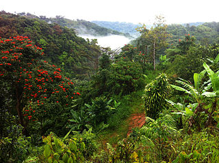
El Yunque National Forest, formerly known as the Caribbean National Forest, is a forest located in northeastern Puerto Rico. It is the only tropical rainforest in the United States National Forest System and the United States Forest Service. El Yunque National Forest is located on the slopes of the Sierra de Luquillo mountains, encompassing more than 28,000 acres of land, making it the largest block of public land in Puerto Rico.
Jayuya is a town and municipality of Puerto Rico located in the mountainous center region of the island, north of Ponce; east of Utuado; and west of Ciales. Jayuya is spread over 10 barrios and Jayuya Pueblo. It is the principal city of the Jayuya Micropolitan Statistical Area.

The common coquí or coquí is a species of frog native to Puerto Rico belonging to the family Eleutherodactylidae. The species is named for the loud call the males make at night. This sound serves two purposes. "CO" serves to repel other males and establish territory while the "KEE" serves to attract females. Since the auditory systems of males and females respond preferentially to different notes of the male call, this is an example of a sex difference in a sensory system. The common coquí is a very important aspect of Puerto Rican culture, and it has become an unofficial territorial symbol of Puerto Rico. The frog is also found elsewhere, and is usually considered an invasive species outside Puerto Rico.

Cordillera Central, is the main mountain range in Puerto Rico. The range crosses the island from west to east and divides it into its northern and southern coastal plains. The Cordillera Central runs eastward from the municipality of Maricao in the west to Aibonito in the central eastern region, and on to the Caribbean in the southeast through the Sierra de Cayey. The Central Mountain Range consists of the Cordillera Central proper and numerous subranges, foothills and ridges that extend throughout the island. Cerro de Punta is both the highest peak of the Cordillera Central and the highest point in Puerto Rico. The Sierra de Luquillo, where El Yunque is located, is sometimes included as a subrange or eastward extension of the Cordillera Central.
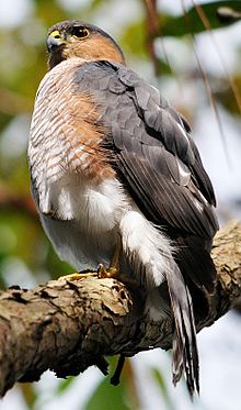
The fauna of Puerto Rico is similar to other island archipelago faunas, with high endemism, and low, skewed taxonomic diversity. Bats are the only extant native terrestrial mammals in Puerto Rico. All other terrestrial mammals in the area were introduced by humans, and include species such as cats, goats, sheep, the small Indian mongoose, and escaped monkeys. Marine mammals include dolphins, manatees, and whales. Of the 349 bird species, about 120 breed in the archipelago, and 47.5% are accidental or rare.
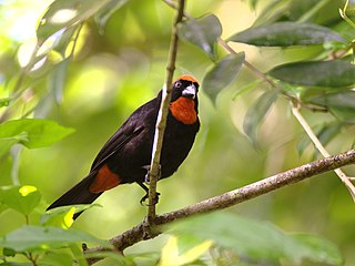
The Puerto Rican bullfinch is a small bullfinch tanager endemic to the archipelago of Puerto Rico. The species can be commonly found in heavy forests throughout Puerto Rico, except on the easternmost tip of the island. It consumes seeds, fruits, insects, and spiders. The nest is spherical, with an entrance on the side. Typically three light green eggs are laid.
Coquí is a common name for several species of small frogs in the genus Eleutherodactylus native to Puerto Rico. They are onomatopoeically named for the very loud mating call which the males of two species, the common coqui and the upland coqui, make at night. The coquí is one of the most common frogs in Puerto Rico, with more than 16 different species found within its territory, including 13 in El Yunque National Forest. Other species of this genus can be found in the rest of the Caribbean and elsewhere in the Neotropics, in Central and South America. The coquí is an unofficial national symbol of Puerto Rico; there is a Puerto Rican expression that goes, "Soy de aquí, como el coquí", which translates to "I'm from here, like the coquí."
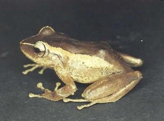
Eleutherodactylus portoricensis is a frog native to Puerto Rico that belongs to the family Eleutherodactylidae. Its vernacular English names are upland coqui, mountain coqui, and Puerto Rican robber frog. The species’ range spans the Luquillo Mountains of northeastern Puerto Rico and the Cordillera Central, which forms the highland “backbone” of Puerto Rico and includes an eastern extension beginning at the city of Cayey. However, the species is likely extirpated from the western Cordillera Central.

Toro Negro State Forest is one of the 21 forests that make up the public forests system in Puerto Rico. It is also Puerto Rico's highest cloud forest. It is in the Cordillera Central region of the island and covers 8,204 cuerdas, of mountains. Toro Negro's mountains have heights reaching up to 4,400 feet (1,300 m) and include Cerro de Punta, Cerro Jayuya and Cerro Rosa, the three highest peaks in the island. Nested among these mountains is Lake Guineo, the island's highest lake. The forest has 18 kilometers (11 mi) of trails, an observation tower, two natural swimming pools (Spanish:"charcos"), camping and picnic areas, nine rivers, and numerous creeks and waterfalls. The forest spans areas within the municipalities of Ponce, Jayuya, Orocovis, Ciales, and Juana Díaz, and consists of seven non-contiguous tracts of land. The largest contiguous segment of the forest is located in the municipalities of Ponce and Jayuya. Some 40% of the area of Toro Negro State Forest is located in Ponce's Barrio Anón.

Anolis cristatellus is a small species of anole, belonging to the Dactyloidae family of reptiles. The species is native to Puerto Rico and the U.S. and British Virgin Islands, with introduced populations in locations around the Caribbean. The males of A. cristatellus are easily recognizable by the fin running down the top of the tail, which is known as a "caudal crest". The females also have this crest, but it is smaller than that of the males. The species is often quite common in many areas on Puerto Rico, where it can be seen during the day passing the time on the lower parts of tree trunks, or on fences and the walls of buildings in urban areas, sometimes venturing down onto the ground in order to lay eggs, have a snack, or do other cursorial activities. Like many anoles, this species displays the characteristic behaviour of doing push-ups as well as inflating a pizza-like flap of coloured skin on its throat, known as a dewlap, in order to show others how dominant it is, and thus attract mates or intimidate rivals.

Anolis stratulus is a moderately-sized species of anole found in Puerto Rico, the United States Virgin Islands and the British Virgin Islands. It is a gray-colored lizard spotted with brown markings. It is arboreal, usually found positioned on tree bark on branches in the canopies of forest trees, where in some areas of Puerto Rico it can be incredibly abundant, with tens of thousands of the lizards being present per hectare.

Carite State Forest is a state forest and nature reserve located in the Sierra de Cayey mountain range in southeastern Puerto Rico. The forest extends over approximately 2,600 hectares and is located in the municipalities of Caguas, Cayey, Guayama, Patillas and San Lorenzo. The forest is located along the Ruta Panorámica, which offers access to the forest.

Guilarte State Forest is one of the 20 forests that make up the public forests system in Puerto Rico. The forest is located in the eastern half of the Central Mountain Range or Cordillera Central. The main geographical feature of the forest reserve is Monte Guilarte, which is Puerto Rico's 7th highest mountain at 3,950 feet above sea level. While Monte Guilarte is located in the municipality of Adjuntas, the forest's borders also include parts of Guayanilla, Peñuelas and Yauco.

Nuevo Milenio State Forest is one of the 20 forests that make up the public forest system of Puerto Rico. The forest is located east of the University of Puerto Rico Botanical Garden in the Sabana Llana Sur district of San Juan, making it one of the two state forests located within the capital's municipal boundaries.

Guajataca State Forest is one of the 20 forests that make up the public forest system of Puerto Rico. The Guajataca Forest is located in the northwestern part of Puerto Rico, along the Northern Karst zone in the municipality of Isabela and municipality of Quebradillas, and is near Camuy and San Sebastián. The forest is renowned for its ecological diversity, the mogotes and karstic formations, and its numerous caves and canyons. It also has the largest trail system of any Puerto Rican state forest.

Mona and Monito Islands Nature Reserve consists of two islands, Mona and Monito, in the Mona Passage off western Puerto Rico in the Caribbean. Mona and Monito Islands Nature Reserve encompasses both land and marine area, and with an area of 38,893 acres it is the largest protected natural area in the Commonwealth of Puerto Rico. Much like the Galapagos Islands in the Pacific Ocean, the Mona and Monito Islands reserve represents a living laboratory for archaeological, biological, geological, oceanographical and wildlife management research.