
The geography of Puerto Rico consists of an archipelago located between the Caribbean Sea and the North Atlantic Ocean, east of the Dominican Republic or Hispaniola, west of the Virgin Islands and north of Venezuela. The main island of Puerto Rico is the smallest and most eastern of the Greater Antilles. With an area of 8,710 square kilometres (3,360 sq mi), it is the third largest island in the United States and the 82nd largest island in the world. Various smaller islands and cays, including Vieques, Culebra, Mona, Desecheo, and Caja de Muertos comprise the remainder of the archipelago with only Culebra and Vieques being inhabited year-round. Mona is uninhabited through large parts of the year except for employees of the Puerto Rico Department of Natural Resources.

Salinas is a town and municipality in the southern part of Puerto Rico located in the southern coast of the island, south of Aibonito and Cayey; southeast of Coamo, east of Santa Isabel; and west of Guayama. Salinas is spread over 5 barrios and Salinas Pueblo.

Cerro Maravilla is Puerto Rico's fourth highest peak at 1,205 meters (3,953 ft). It is located on the northern edge Barrio Anón in Ponce, close to the border with the municipality Jayuya, and is part of the Cordillera Central. It is known as El Cerro de los Mártires and characterized as the most infamous peak in Puerto Rico, due to the 1978 Cerro Maravilla murders which took place here.
Jayuya is a town and municipality of Puerto Rico located in the mountainous center region of the island, north of Ponce; east of Utuado; and west of Ciales. Jayuya is spread over 10 barrios and Jayuya Pueblo. It is the principal city of the Jayuya Micropolitan Statistical Area.

Cerro de Punta or just Cerro Punta is the highest peak in Puerto Rico, rising to 1,338 meters (4,390 ft) above sea level. The mountain is part of the Cordillera Central and is located in the municipality of Ponce.

Pico Turquino, sometimes erroneously spelled as Pico Torquino, is the highest point in Cuba. It is located in the southeast part of the island, in the Sierra Maestra mountain range in the municipality of Guamá, Santiago de Cuba Province.

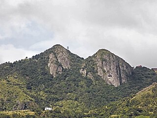
Cerro Las Tetas, nicknamed Las Tetas de Cayey but officially Las Piedras del Collado, are two mountain peaks located in the municipality of Salinas, Puerto Rico, north of the city of Salinas proper. Since September 1, 2000, the peaks have become part of the Las Piedras del Collado Nature Reserve and are protected by law. Their height is 2,762 feet (842 m) above sea level.

Cordillera Central, is the main mountain range in Puerto Rico. The range crosses the island from west to east and divides it into its northern and southern coastal plains. The Cordillera Central runs eastward from the municipality of Maricao in the west to Aibonito in the central eastern region, and on to the Caribbean in the southeast through the Sierra de Cayey. The Central Mountain Range consists of the Cordillera Central proper and numerous subranges, foothills and ridges that extend throughout the island. Cerro de Punta is both the highest peak of the Cordillera Central and the highest point in Puerto Rico. The Sierra de Luquillo, where El Yunque is located, is sometimes included as a subrange or eastward extension of the Cordillera Central.

Toro Negro State Forest is one of the 21 forests that make up the public forests system in Puerto Rico. It is also Puerto Rico's highest cloud forest. It is in the Cordillera Central region of the island and covers 8,204 cuerdas, of mountains. Toro Negro's mountains have heights reaching up to 4,400 feet (1,300 m) and include Cerro de Punta, Cerro Jayuya and Cerro Rosa, the three highest peaks in the island. Nested among these mountains is Lake Guineo, the island's highest lake. The forest has 18 kilometers (11 mi) of trails, an observation tower, two natural swimming pools (Spanish:"charcos"), camping and picnic areas, nine rivers, and numerous creeks and waterfalls. The forest spans areas within the municipalities of Ponce, Jayuya, Orocovis, Ciales, and Juana Díaz, and consists of seven non-contiguous tracts of land. The largest contiguous segment of the forest is located in the municipalities of Ponce and Jayuya. Some 40% of the area of Toro Negro State Forest is located in Ponce's Barrio Anón.

Anón is one of the 31 barrios in the municipality of Ponce, Puerto Rico. Along with Marueño, Coto Laurel, Guaraguao, Quebrada Limon, Real, and San Patricio, and the coastal barrios of Canas and Capitanejo, Anón is one of the municipality's nine bordering barrios. Anón borders the municipalities of Jayuya and Juana Diaz. The name of this barrio is of native Indian origin. It was founded in 1878. Barrio Anón is one of three Ponce barrios located on the Cordillera Central mountain range.
Sierra de Cayey is a mountain range in the main island of Puerto Rico. It is located in the southeast section of the island. Its elevations do not exceed 1000 m.

Guilarte State Forest is one of the 20 forests that make up the public forests system in Puerto Rico. The forest is located in the eastern half of the Central Mountain Range or Cordillera Central. The main geographical feature of the forest reserve is Monte Guilarte, which is Puerto Rico's 7th highest mountain at 3,950 feet above sea level. While Monte Guilarte is located in the municipality of Adjuntas, the forest's borders also include parts of Guayanilla, Peñuelas and Yauco.
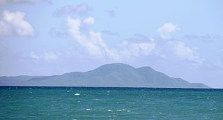
Monte Pirata, at 960 feet of elevation, is the highest mountain in the island of Vieques. The mountain is located in the western portion of the Vieques National Wildlife Refuge and it is the site of an old US Navy communications site, now operated by the Department of Homeland Security]. Hiking used to be permitted in the mountain, and there is a trail leads to the summit. Although the main trail has been closed to the general public for the past 20 years, an observation platform is being installed and currently there is interest in revitalizing and reopening the entire area.
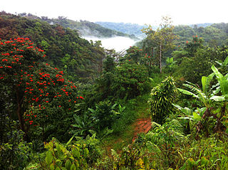
Palmas del Mar Tropical Forest, also known as the Palmas del Mar Pterocarpus Forest, is located in and near the beach resort community of Palmas del Mar in Humacao, Puerto Rico. The 144 acres of forest tracts belonging to the Palmas del Mar Tropical Forest are protected by conservation easement laws between Palmas del Mar Properties Inc. and the Conservation Trust of Puerto Rico since 2010. It consists of secondary forests, mangroves and, most notably, a Pterocarpus forest. The Candelero River also crosses the forest area and its mouth is also located just north of the forest limits.

El Rabanal is a small, protected area consisting of 16 acres of critical secondary forest in the municipality of Cidra, Puerto Rico. The forest tract is located in barrio Rabanal, in a 5,438-acre hydrological basin which is home to 21 species of birds, seven out of which are endemic to the region, including the Puerto Rican plain pigeon. This protected area was established through the Asociación de Pequeños Agricultores de Rabanal Inc. (APARI) and the Puerto Rico Conservation Trust in 2002 with the goal of protecting the area from urban development and developing educational programs related to sustainable agriculture and environmental education.
The Foreman Conservation Easement is a protected natural area in the Cordillera Central of Puerto Rico, located in the municipality of Adjuntas. This protected area was the first conservation easement site to be established in the history of Puerto Rico; these are designated areas established through an agreement between a governmental body and private owners or entities to preserve natural areas from urban development.

Cerro La Santa is a 2,962 feet high mountain and the highest point in the Sierra de Cayey in Puerto Rico. The peak of Cerro La Santa is located in the Carite State Forest, at a tri-point shared by the municipalities of Caguas, Cayey (Farallón) and San Lorenzo (Espino).

Sierra Pandura, also known as Cuchilla de Pandura and La Pica, is a mountain range that runs from the Sierra de Cayey in the northwest to the Caribbean Sea in the southeast in southeastern Puerto Rico, between the municipalities of Maunabo and Yabucoa. Together with the Sierra de Guardarraya to the south, Sierra Pandura is part of the San Lorinzo batholith physiological region, a composite body of volcanic origin which bifurcates the mountain ridge.
