The geography of Puerto Rico consists of an archipelago located between the Caribbean Sea and the North Atlantic Ocean, east of the Dominican Republic or Hispaniola, west of the Virgin Islands and north of Venezuela. The main island of Puerto Rico is the smallest and most eastern of the Greater Antilles. With an area of 3,515 square miles (9,104 km2), it is the third largest island in the United States and the 82nd largest island in the world. Various smaller islands and cays, including Vieques, Culebra, Mona, Desecheo, and Caja de Muertos comprise the remainder of the archipelago with only Culebra and Vieques being inhabited year-round. Mona is uninhabited through large parts of the year except for employees of the Puerto Rico Department of Natural Resources.

El Yunque National Forest, formerly known as the Caribbean National Forest, is a forest located in northeastern Puerto Rico. It is the only tropical rainforest in the United States National Forest System and the United States Forest Service. El Yunque National Rainforest is located on the slopes of the Sierra de Luquillo mountains, encompassing 28,000 acres of land, making it the largest block of public land in Puerto Rico.

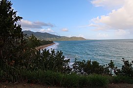
Yabucoa is a town and municipality in Puerto Rico located in the eastern region, north of Maunabo; south of San Lorenzo, Las Piedras and Humacao; and east of Patillas. Yabucoa is spread over 9 barrios and Yabucoa Pueblo. It is part of the San Juan-Caguas-Guaynabo Metropolitan Statistical Area.

Maunabo is a town and municipality of Puerto Rico located in the Maunabo Valley on the southeastern coast, northeast of Patillas and south of Yabucoa. Maunabo is spread over eight barrios and Maunabo Pueblo. It is part of the San Juan-Caguas-Guaynabo Metropolitan Statistical Area. The current mayor of the town is Jorge L. Márquez Pérez and the population in 2020 was 10,589.

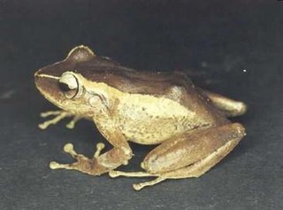
The common coquí or coquí is a species of frog endemic to Puerto Rico belonging to the family Eleutherodactylidae. The species is named for the loud call the males make at night. This sound serves two purposes. "CO" serves to repel other males and establish territory while the "KEE" serves to attract females. Since the auditory systems of males and females respond preferentially to different notes of the male call, this is an example of a sex difference in a sensory system. The common coquí is a very important aspect of Puerto Rican culture, and it has become an unofficial territorial symbol of Puerto Rico.

The golden coquí is a rare species of frog endemic to Puerto Rico.

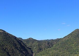
Cordillera Central, is the main mountain range in Puerto Rico. The range crosses the island from west to east and divides it into its northern and southern coastal plains. The Cordillera Central runs eastward from the municipality of Maricao in the west to Aibonito in the central eastern region, and on to the Caribbean in the southeast through the Sierra de Cayey. The Central Mountain Range consists of the Cordillera Central proper and numerous subranges, foothills and ridges that extend throughout the island. Cerro de Punta is both the highest peak of the Cordillera Central and the highest point in Puerto Rico. The Sierra de Luquillo, where El Yunque is located, is sometimes included as a subrange or eastward extension of the Cordillera Central.
Eleutherodactylus portoricensis is a frog native to Puerto Rico that belongs to the family Eleutherodactylidae. Its vernacular English names are upland coqui, mountain coqui, and Puerto Rican robber frog. It is found in the Toro Negro State Forest and other similar mountainous regions.

Toro Negro State Forest is one of the 21 forests that make up the public forests system in Puerto Rico. It is also Puerto Rico's highest cloud forest. It is in the Cordillera Central region of the island and covers 8,204 cuerdas, of mountains. Toro Negro's mountains have heights reaching up to 4,400 feet (1,300 m) and include Cerro de Punta, Cerro Jayuya and Cerro Rosa, the three highest peaks in the island. Nested among these mountains is Lake Guineo, the island's highest lake. The forest has 18 kilometers (11 mi) of trails, an observation tower, two natural swimming pools (Spanish:"charcos"), camping and picnic areas, nine rivers, and numerous creeks and waterfalls. The forest spans areas within the municipalities of Ponce, Jayuya, Orocovis, Ciales, and Juana Díaz, and consists of seven non-contiguous tracts of land. The largest contiguous segment of the forest is located in the municipalities of Ponce and Jayuya. Some 40% of the area of Toro Negro State Forest is located in Ponce's Barrio Anón.

The Puerto Rican rock frog, Eleutherodactylus cooki, also known as the Puerto Rican cave-dwelling frog or rock coqui, and locally as coquí guajón, or guajón for brevity, is a threatened frog species from the coqui genus. This unique species of tropical frogs dwells primarily in crevices and grottos in the Cuchilla de Panduras mountain range in southeastern Puerto Rico. The native name guajón is derived from its habitat, guajonales, which are caves formed by rock formations between huge stones. Despite being the state animal and considered emblematic of the region, of the 17 species of coquí, three are believed to be extinct and the rest are rare and declining in numbers. The Puerto Rican rock frog is extremely restricted in geographical distribution. The frog is threatened due to deforestation, agricultural, rural, and industrial development, and the associated infrastructure. It is sometimes called the “demon of Puerto Rico" because of its eerie call and phantom-like appearance. The species was first described by American herpetologist, Chapman Grant in 1932.
Juan Martín is a barrio in the municipality of Yabucoa, Puerto Rico. Its population in 2010 was 3,891.

Carite State Forest is a state forest and nature reserve located in the Sierra de Cayey mountain range in southeastern Puerto Rico. The forest extends over approximately 6,500 acres and is located in the municipalities of Caguas, Cayey, Guayama, Patillas and San Lorenzo. The forest is located along the Ruta Panorámica, which offers access to the forest.

Guilarte State Forest is one of the 20 forests that make up the public forests system in Puerto Rico. The forest is located in the eastern half of the Central Mountain Range or Cordillera Central. The main geographical feature of the forest reserve is Monte Guilarte, which is Puerto Rico's 7th highest mountain at 3,950 feet above sea level. While Monte Guilarte is located in the municipality of Adjuntas, the forest's borders also include parts of Guayanilla, Peñuelas and Yauco.

The protected areas of Puerto Rico include an array of natural areas in the archipelago of Puerto Rico, an unincorporated territory of the United States, managed by a number of agencies and entities belonging to both federal and commonwealth government bodies. Although Puerto Rico has no natural units in the National Park System, the biodiversity of the island is recognized and protected through a national forest, a national wildlife refuge, a national wilderness, and numerous state parks, nature reserves, state forests, wildlife preserves and other designations on state, municipal and public-private administration levels.

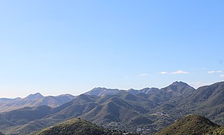
Cerro La Santa is a 2,962 feet high mountain and the highest point in the Sierra de Cayey in Puerto Rico. The peak of Cerro La Santa is located in the Carite State Forest, at a tri-point shared by the municipalities of Caguas, Cayey (Farallón) and San Lorenzo (Espino).

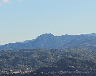
Cerro Planada is a mountain peak located in Cayey, Puerto Rico. The mountain has an elevation of 2,480 feet, making it the 10th highest peak of the Sierra de Cayey.
The Planadas-Yeyesa Nature Reserve is a protected nature reserve located in the Sierra de Cayey, in the municipalities of Cayey and Salinas in central Puerto Rico. The reserve is located close to the famous Cerro Las Tetas. Two of the most prominent features of the reserve are Cerro Planada, a 2,480 feet high mountain peak, and La Yeyesa, a heavily forested canyon formed by the Lapa River and other streams which feed into the Nigua River. La Yeyesa can be accessed through a lightly trafficked yet moderate trail.
Montes Oscuros is a small mountain range located between the Sierra de Cayey and the main Cordillera Central, on the municipalities of Coamo and Salinas in southern Puerto Rico. The mountain range and its environment are protected from urban development through a conservation easement, designated as the Montes Oscuros Scenic Easement.
Cerro Gregorio is a mountain of the Sierra de Cayey measuring 2,043 feet in elevation. The mountain is located in the barrios Jagual and Quebrada Honda in the municipality of San Lorenzo, Puerto Rico, close to the municipal boundary with Caguas. The mountain is the site of El Cerro de Nandy, a restaurant and local tourism destination.