
Puerto Rico, officially the Commonwealth of Puerto Rico, is an archipelagic island U.S. territory comprised of the eponymous main island of Puerto Rico and 142 smaller islands, cays, and islets, including Vieques, Culebra, Mona, Desecheo, Caja de Muertos, Palominos, and Icacos, located between the Greater and Lesser Antilles in the northeast Caribbean Sea of the North Atlantic Ocean. The main island of Puerto Rico is 113 km east of Hispaniola, 60 km west of the U.S. Virgin Islands, 705 km north of Venezuela, and 120 km south of the Puerto Rico Trench, the deepest point in the Atlantic. The main island is about 178 km long and 65 km. With a land area of 8,868 sq km, it is the 4th largest island in the Caribbean, 81st largest island in the world, and the 174th largest country, dependency, or disputed territory.

Isla Culebra is an island, town and municipality of Puerto Rico, and together with Vieques, it is geographically part of the Spanish Virgin Islands. It is located approximately 17 miles (27 km) east of the Puerto Rican mainland, 12 miles (19 km) west of St. Thomas and 9 miles (14 km) north of Vieques. Culebra is spread over 5 barrios and Culebra Pueblo (Dewey), the main town and the administrative center of the island. Residents of the island are known as culebrenses. With a population of 1,792 as of the 2020 Census, it is Puerto Rico's least populous municipality.

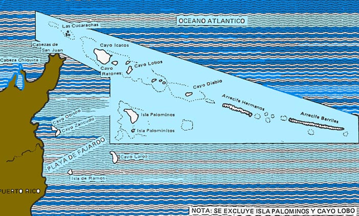
Fajardo is a town and a municipality part of the San Juan-Caguas-Fajardo Combined Statistical Area in Puerto Rico.

The Federal Dependencies of Venezuela encompass most of Venezuela's offshore islands in the Caribbean Sea and the Gulf of Venezuela, excluding those islands that form the State of Nueva Esparta and some Caribbean coastal islands that are integrated with nearby states. These islands, with a total area of 342 square kilometres, are sparsely populated – according to the preliminary results of the 2011 Census only 2,155 people live there permanently, with another hundred from Margarita Island who live there seasonally to engage in fishing. Local government is officially under the authority of Central government in Caracas, although de facto power is often held by the heads of the sparse and somewhat isolated communities that decorate the territories.
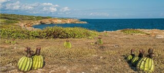
The Guánica State Forest, popularly known as the Guánica Dry Forest is a subtropical dry forest located in southwest Puerto Rico. The area was designated as a forest reserve in 1919 and a United Nations Biosphere Reserve in 1981. It is considered the best preserved subtropical dry forest and the best example of dry forest in the Caribbean.

Bahía de Jobos or Reserva Natural de Investigación Estuarina de Bahía de Jobos is a federally protected estuary in Aguirre, Salinas, Puerto Rico. The bay is an intertidal tropical ecosystem dominated by seagrass beds, coral reefs, and mangroves. In an area of 1,140 hectares, the reserve contains five distinct habitat types and provides sanctuary to several endangered species. Bahía de Jobos is one of 28 reserves that comprise the National Oceanic and Atmospheric Administration’s (NOAA) National Estuarine Research Reserve System. The reserve is operated in conjunction with the Puerto Rico Department of Natural and Environmental Resources (DRNA).

The Miskito Cays are an archipelago with an area of 27 km2 located off shore in the northeastern Caribbean coast of Nicaragua, part of the North Caribbean Coast Autonomous Region. The Miskito Cays are composed of 76 formations that include estuaries, coral reefs, cays, seagrass beds, and islets, of which 12 of the formations are covered with vegetation and consequently form islands which are lined with white sand beaches.

Palominos Island is a small island located off the coast of the barrio of Cabezas in the municipality of Fajardo to the northeast of the main island of Puerto Rico. It forms part of a small chain of cays, reefs, and islets protected by the La Cordillera Reef Nature Reserve. The island is home to El Conquistador Resort.

Cape San Juan Light is a historic lighthouse located on the northeastern part of the highest point of Cape San Juan in Fajardo, Puerto Rico. The lighthouse was constructed in 1880 and was officially lit on May 2, 1882. The original illuminating apparatus, not changed until after 1898, had an 18-mile (29 km) range and displayed a fixed white light which every three minutes flashed red.

The Northeast Ecological Corridor Nature Reserve (NECNR) refers to an area designated as a protected Nature Reserve located on the northeast coast of Puerto Rico, between the municipalities of Luquillo and Fajardo. Specifically, the lands that comprise the NEC are located between Luquillo's town square to the west and Seven Seas Beach to the east, being delineated by PR Route # 3 to its south and the Atlantic Ocean to its north. It was decreed as a protected area by former Puerto Rico Governor Aníbal S. Acevedo-Vilá in April 2008, a decision reversed by Governor Luis G. Fortuño-Burset in October 2009, although he later passed a law in June 2012 re-designated as nature reserve two-thirds of its lands, after intense lobbying and public pressure. Later, in 2013, Governor Alejandro García-Padilla signed a law declaring all lands within the NEC a nature reserve. The area comprises 2,969.64 acres, which include such diverse habitats as forest, wetlands, beaches, coral communities, and a sporadically bioluminescent lagoon. The Corridor is also home to 866 species of flora and fauna, of which 54 are considered critical elements, meaning rare, threatened, endangered and endemic species classified by the Puerto Rico Department of Natural and Environmental Resources (DNER), some even designated as critically endangered by the International Union for Conservation of Nature and Natural Resources (IUCN). These include, among others, federally endangered species such as the plain pigeon, the snowy plover, the Puerto Rican boa, the hawksbill sea turtle and the West Indian manatee. The beaches along the NEC, which are 8.74 kilometers long are important nesting grounds for the leatherback sea turtle, which starts its nesting season around April each year.
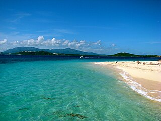
Icacos Cay is the largest uninhabited cay forming part of a small chain of cays, reefs, and islets located off the coast of the barrio of Cabezas in the municipality of Fajardo in northeastern Puerto Rico. Along with Palominos island, it is part of the La Cordillera Reef Nature Reserve and under the jurisdiction of the Department of Natural Resources and Environment. Icacos is a fifteen-minute water taxi ride from Fajardo. The cay is a popular snorkeling and beach tourism destination.

Ceiba State Forest, also referred to as the Ceiba State Reserve, is a mangrove forest and nature reserve located in the eastern coast of Puerto Rico, in the municipalities of Ceiba and Fajardo. The forest extends over 350 acres and is mostly made of mangrove forests which are habitat to a large number of bird species. Although named Ceiba State Forest, the forest is not home to the large ceiba tree, and it is actually named after the municipality it is located in. In addition to the mangrove forests, the reserve also includes coastal zones that comprise sandy beaches and coral reefs found in both the Ceiba and Fajardo sections.

Caja de Muertos Nature Reserve is a nature reserve in southern Puerto Rico consisting of the islands of Caja de Muertos, Cayo Morrillito, Cayo Berbería, and their surrounding reefs and waters in the Caribbean Sea. This nature reserve was founded on January 2, 1980, by the Puerto Rico Planning Board as recommended by the Puerto Rico Department of Natural and Environmental Resources with the purpose of preserving the subtropical dry forest ecosystems found within these islands, some important sea turtle nesting sites, and the marine habitats found on their surrounding reefs and waters.

Isla Verde Reef is a reef that surrounds Isla Verde Key, located off the coast of Punta del Medio in Isla Verde, Carolina, in the Atlantic coast of Puerto Rico. The Isla Verde Reef, protected as the Isla Verde Reef Marine Reserve, forms part of a larger reef system that extends from Punta Maldonado in Piñones, Loíza to the San Juan Islet. This is one of the three designated marine reserves in Puerto Rico, the other two being the Desecheo Coastal Waters and Tres Palmas marine reserves off the western coast of Puerto Rico, and the only one that protects a coral reef ecosystem on an urban area. The reserve is home to endangered species such as manatees, sea turtles and federally protected coral species such as the elkhorn coral. The coral reef is also an ideal place for fish spawning which is important for the fishing industry of the region. The Isla Verde Reef is protected through community organizations such as Arrecifes Pro Ciudad, and public organisms such as Para la Naturaleza, with support from academic institutions such as the University of Puerto Rico at Bayamón.

Punta Petrona is a cape and protected area located in southern Puerto Rico, in the Felicia 1 district of the municipality of Santa Isabel. Located in the Caribbean Sea coast, it is bordered by the Rincón Bay to the east, and the bight of Caja de Muertos to the west. Punta Petrona contains a mangrove forest and it is surrounded by small keys that serve as a habitat for the West Indian manatee. It is also an important coral reef area frequented by sea turtles. The area is protected as the Punta Petrona Natural Reserve, part of the wider Aguirre State Forest; however, the Puerto Rican Planning Society revealed in 2018 that this nature reserve did not have the proper state management and classification regulations.

Tourmaline Reef is a shelf-edge reef located in the Mona Passage off Mayagüez Bay in western Puerto Rico. The reef is one of the best-preserved reefs of its type in Puerto Rico as it is found far away enough from the coast and was selected as one of the first coral reef protection zones under the Puerto Rico Coastal Zone Management Program. Tourmaline Reef is located close to Punta Guanajibo, at 7.5 nautical miles from Mayagüez, at depths of up to 10 meters under the ocean surface bordering in waters of moderate to high visibility due to minimal terrigenous or sedimentary deposits.
Nature Reserve of Puerto Rico is a title and special designation given by the upper house of the Legislative Assembly of Puerto Rico to specific natural areas or features throughout the territory. All nature reserves in Puerto Rico are protected by Puerto Rico Law #150, first approved on August 8, 1988, better known as the Puerto Rico Natural Heritage Program Act that seeks to protect the natural resources of the island for the purpose of natural preservation and tourism. These are managed by different agencies within the Puerto Rico Department of Natural and Environmental Resources, public-private partnerships such as the Conservation Trust of Puerto Rico and its management unit Para la naturaleza, and other grassroots and community institutions and programs.

La Parguera Nature Reserve is a protected area located in the southwestern Puerto Rico, primarily in the municipality of Lajas but also covering cays and islets under the municipal jurisdictions of Guánica and Cabo Rojo. The nature reserve is itself a unit of the Boquerón State Forest and it protects the Bahía Montalva mangrove forest in addition to mangrove bays, salt marshes and lagoons located along the coast of the Parguera barrio of Lajas, including its numerous cays and coral reefs. The reserve is mostly famous for its bioluminescent bay, locally called Bahía Fosforecente,, one of the three of its kind in Puerto Rico and one of the seven year-round places where bioluminescent can be seen in the Caribbean.


