
Puerto Rico, officially the Commonwealth of Puerto Rico, is an archipelagic island U.S. territory comprised of the eponymous main island of Puerto Rico and 142 smaller islands, including Vieques, Culebra, and Mona. It is located between the Greater and Lesser Antilles in the northeastern Caribbean Sea, east of Hispaniola, west of Saint Thomas, north of Venezuela, and south of the Puerto Rico Trench. Measuring 177 km in length and 65 km in width with a land area of 8,868 sq km, the main island is the 3rd largest in the U.S., 4th in the Caribbean, 29th in the Americas, and 81st in the world, making it the 174th largest country or dependency by surface area. With 3.2 million residents, it is the 2nd largest in the U.S., 4th in the Caribbean, 4th in the Americas, and 31st in the world, making it the 136th largest country or dependency by population.

Palmas del Mar is a beach resort community consisting of a country club, golf courses, tennis, a beach club, residences and a hotel. It is located in the municipality of Humacao, Puerto Rico, on the southeast corner of the island.
Guanacaste Conservation Area is an administrative area which is managed by the Sistema Nacional de Areas de Conservacion (SINAC) of Costa Rica for conservation in the northwestern part of Costa Rica. It contains three national parks, as well as wildlife refuges and other nature reserves. The area contains the Area de Conservación Guanacaste World Heritage Site, which comprises four areas.

Hacienda Buena Vista, also known as Hacienda Vives, was a coffee plantation located in Barrio Magueyes, Ponce, Puerto Rico. The original plantation dates from the 19th century. The plantation was started by Don Salvador de Vives in 1833.
Fundación de Conservación Jocotoco is an Ecuadorian non-governmental environmental organization. It was established to purchase and protect land important to the conservation of endangered birds in Ecuador.

Toro Negro State Forest is one of the 21 forests that make up the public forests system in Puerto Rico. It is also Puerto Rico's highest cloud forest. It is in the Cordillera Central region of the island and covers 8,204 cuerdas, of mountains. Toro Negro's mountains have heights reaching up to 4,400 feet (1,300 m) and include Cerro de Punta, Cerro Jayuya and Cerro Rosa, the three highest peaks in the island. Nested among these mountains is Lake Guineo, the island's highest lake. The forest has 18 kilometers (11 mi) of trails, an observation tower, two natural swimming pools (Spanish:"charcos"), camping and picnic areas, nine rivers, and numerous creeks and waterfalls. The forest spans areas within the municipalities of Ponce, Jayuya, Orocovis, Ciales, and Juana Díaz, and consists of seven non-contiguous tracts of land. The largest contiguous segment of the forest is located in the municipalities of Ponce and Jayuya. Some 40% of the area of Toro Negro State Forest is located in Ponce's Barrio Anón.
The Bairoa River is a river of Caguas, Puerto Rico.

The Puerto Rican moist forests are a tropical moist broadleaf forest ecoregion in Puerto Rico. They cover an area of 7,544 km2 (2,913 sq mi).

The Northeast Ecological Corridor Nature Reserve (NECNR) refers to an area designated as a protected Nature Reserve located on the northeast coast of Puerto Rico, between the municipalities of Luquillo and Fajardo. Specifically, the lands that comprise the NEC are located between Luquillo's town square to the west and Seven Seas Beach to the east, being delineated by PR Route # 3 to its south and the Atlantic Ocean to its north. It was decreed as a protected area by former Puerto Rico Governor Aníbal S. Acevedo-Vilá in April 2008, a decision reversed by Governor Luis G. Fortuño-Burset in October 2009, although he later passed a law in June 2012 re-designated as nature reserve two-thirds of its lands, after intense lobbying and public pressure. Later, in 2013, Governor Alejandro García-Padilla signed a law declaring all lands within the NEC a nature reserve. The area comprises 2,969.64 acres, which include such diverse habitats as forest, wetlands, beaches, coral communities, and a sporadically bioluminescent lagoon. The Corridor is also home to 866 species of flora and fauna, of which 54 are considered critical elements, meaning rare, threatened, endangered and endemic species classified by the Puerto Rico Department of Natural and Environmental Resources (DNER), some even designated as critically endangered by the International Union for Conservation of Nature and Natural Resources (IUCN). These include, among others, federally endangered species such as the plain pigeon, the snowy plover, the Puerto Rican boa, the hawksbill sea turtle and the West Indian manatee. The beaches along the NEC, which are 8.74 kilometers long are important nesting grounds for the leatherback sea turtle, which starts its nesting season around April each year.

Ariel E. Lugo is a scientist, ecologist and former Director of the International Institute of Tropical Forestry (IITF) within the USDA United States Forest Service, based in Puerto Rico. He is a founding member of the Society for Ecological Restoration and Member-at-Large of the Board of the Ecological Society of America.
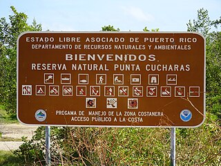
Reserva Natural Punta Cucharas is a nature reserve in Barrio Canas, Ponce, Puerto Rico. It consists of both a land area component as well as an offshore marine area. The land component has an area of 698 cuerdas while the marine component has an expanse of 3,516 cuerdas, for a total area of 4,214 cuerdas. The Reserve consists of mangrove ecosystems, coastal sand dunes, a saline lagoon known as Laguna Las Salinas, open water, and a century-old local community. The lagoon occupies and area of 347,898 m2 Ecological protection is managed and enforced by the Puerto Rico Department of Natural and Environmental Resources. Eight activities are allowed at the Reserve: scuba diving, boating, fishing, hiking, sun bathing, photography, bird watching and canoeing. Activities prohibited are: Camping, crabbing/trapping, horseback riding, water crafting, and hunting. Pets, ATVs, and fireplaces are also prohibited.

Nuevo Milenio State Forest is one of the 20 forests that make up the public forest system of Puerto Rico. The forest is located east of the University of Puerto Rico Botanical Garden in the Sabana Llana Sur district of San Juan, making it one of the two state forests located within the capital's municipal boundaries.

Humacao Nature Reserve, or the Punta Santiago Nature Reserve, is a nature reserve located in the southeastern coast of Puerto Rico, between the municipalities of Humacao and Naguabo (Río). The 3,000-acre nature reserve was established in 1986 to protect and preserve the remaining Pterocarpus forest ecosystem in the area, along with its surrounding wetlands and mangrove forests.

El Rabanal is a small, protected area consisting of 16 acres of critical secondary forest in the municipality of Cidra, Puerto Rico. The forest tract is located in barrio Rabanal, in a 5,438-acre hydrological basin which is home to 21 species of birds, seven out of which are endemic to the region, including the Puerto Rican plain pigeon. This protected area was established through the Asociación de Pequeños Agricultores de Rabanal Inc. (APARI) and the Puerto Rico Conservation Trust in 2002 with the goal of protecting the area from urban development and developing educational programs related to sustainable agriculture and environmental education.
The Foreman Conservation Easement is a protected natural area in the Cordillera Central of Puerto Rico, located in the municipality of Adjuntas. This protected area was the first conservation easement site to be established in the history of Puerto Rico; these are designated areas established through an agreement between a governmental body and private owners or entities to preserve natural areas from urban development.
Montes Oscuros is a small mountain range located between the Sierra de Cayey and the main Cordillera Central, on the municipalities of Coamo and Salinas in southern Puerto Rico. The mountain range and its environment are protected from urban development through a conservation easement, designated as the Montes Oscuros Scenic Easement.

Vega State Forest is a state forest of Puerto Rico located in the municipalities of Vega Alta and Vega Baja. The subtropical moist forest is located in the northern coast of Puerto Rico in the middle of the karst zone known as the Carso Norteño, and it contains features typical of such geography such as sinkholes, caves and mogotes. It was designated a nature reserve in 1952 and it is fully protected by the Puerto Rico Forest laws of 1975. The forest has a total area of 1,150 acres, divided into six forest units throughout the municipalities of Vega Alta and Vega Baja.

Frank Howard Wadsworth was an American forester, conservationist and researcher. He made important scientific contributions to forestry, through his work in Puerto Rico where he lived from 1942 until his death.
Nature Reserve of Puerto Rico is a title and special designation given by the upper house of the Legislative Assembly of Puerto Rico to specific natural areas or features throughout the territory. All nature reserves in Puerto Rico are protected by Puerto Rico Law #150, first approved on August 8, 1988, better known as the Puerto Rico Natural Heritage Program Act that seeks to protect the natural resources of the island for the purpose of natural preservation and tourism. These are managed by different agencies within the Puerto Rico Department of Natural and Environmental Resources, public-private partnerships such as the Conservation Trust of Puerto Rico and its management unit Para la naturaleza, and other grassroots and community institutions and programs.
