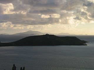
Culebrita Island is a small, uninhabited island off the eastern coast of the island-municipality of Culebra in the Spanish Virgin Islands, administratively part of the archipelago of Puerto Rico and geographically part of the archipelago of the Virgin Islands. Together with Cayo Botella off the northwestern point, and Pelá and Pelaita to the west, Culebrita belongs to the barrio Fraile of the main island of Culebra. It is a nature reserve and is part of the Culebra National Wildlife Refuge. The island is home to Culebrita Lighthouse, one of the oldest lighthouses in the Caribbean. Culebrita is only accessible by private boat from the main island of Culebra.
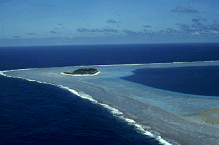
Rose Atoll, sometimes called Rose Island or Motu O Manu by people of the Manu'a Islands, is an oceanic atoll within the U.S. territory of American Samoa. An uninhabited wildlife refuge, it is the southernmost point belonging to the United States, about 170 miles to the east of Tutuila, the principal island of American Samoa. The land area is just 0.05 km2 at high tide. The total area of the atoll, including lagoon and reef flat amounts to 6.33 km2. Just west of the northernmost point is a channel into the lagoon, about 80 metres (260 ft) wide. There are two islets on the northeastern rim of the reef, larger Rose Island, 3.5 metres (11 ft) high, in the east and the non-vegetated Sand Island, 1.5 metres (5 ft) high, in the north.
Laguna Atascosa National Wildlife Refuge is the largest protected area of natural habitat left in the Lower Rio Grande Valley. The 120,000-acre (49,000 ha) refuge is located almost entirely in Cameron County, Texas, 25 mi (40 km) east of Harlingen, although a very small part of its northernmost point extends into southern Willacy County.

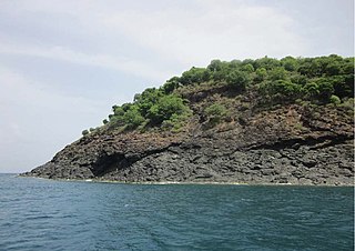
Desecheo is a small uninhabited island of the archipelago of Puerto Rico in the northeast of the Mona Passage; 13 mi (21 km) from the municipality of Rincón on the west coast of the main island of Puerto Rico and 31 mi (50 km) northeast of Mona Island. It has a land area of 0.589 sq mi. Politically, the island is administered by the U.S. Department of the Interior, U.S. Fish and Wildlife Service as the Desecheo National Wildlife Refuge, but part of the Sabanetas barrio of Mayagüez.
Cayo Norte, formerly West Key or North East Key is the largest privately owned island in Puerto Rico and is currently the property of Google co-founder Larry Page via SVI Investments, Inc. The island is located about 0.6 nautical mile (1.0 km) northeast of Culebra Island. It lies 21 nautical miles (36 km) east of Puerto Rico and 12 nautical miles (20 km) west of St. Thomas, U.S. Virgin Islands. The island is part of the municipality of Culebra and therein of the barrio San Isidro. It is the only privately owned island in the Culebra archipelago, and is not part of the Culebra National Wildlife Refuge as are most of the other nearby islands and keys.

The Spanish Virgin Islands, formerly called the Passage Islands, commonly known as the Puerto Rican Virgin Islands, consist of the islands of Vieques and Culebra, located between the main island of Puerto Rico and the U.S. Virgin Islands in the northeastern Caribbean. Located between the Greater and Lesser Antilles, the islands are administratively part of the archipelago of Puerto Rico, and geographically part of the archipelago of the Virgin Islands of the Leeward Islands in the Lesser Antilles.

The fauna of Puerto Rico is similar to other island archipelago faunas, with high endemism, and low, skewed taxonomic diversity. Bats are the only extant native terrestrial mammals in Puerto Rico. All other terrestrial mammals in the area were introduced by humans, and include species such as cats, goats, sheep, the small Indian mongoose, and escaped monkeys. Marine mammals include dolphins, manatees, and whales. Of the 349 bird species, about 120 breed in the archipelago, and 47.5% are accidental or rare.
Caribbean Islands National Wildlife Complex is an administrative unit of the United States Fish and Wildlife Service which oversees National Wildlife Refuges in Puerto Rico, the U.S. Virgin Islands, and Navassa Island of the U.S. Minor Outlying Islands. The NWR complex also reintroduces the critically endangered Puerto Rican parrot into the wild.
Ilex cookii is a species of plant in the family Aquifoliaceae. It is endemic to Puerto Rico. It is threatened by habitat loss. It is a federally listed endangered species of the United States.

Laguna Tortuguero Natural Reserve is a natural reservoir located between the municipalities of Vega Baja and Manatí in Puerto Rico.

Cabo Rojo National Wildlife Refuge is an 1,836-acre National Wildlife Refuge located in southwestern Puerto Rico, in the municipality of Cabo Rojo. The refuge is a habitat for number of native bird species including the endangered yellow-shouldered blackbird, locally known as mariquita de Puerto Rico or capitán. Many birds find their way to the refuge while migrating between North and South America, and more than 118 bird species have been recorded near the area.
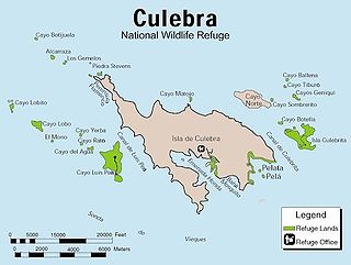
The Culebra National Wildlife Refuge is a National Wildlife Refuge in Puerto Rico. It is part of the Caribbean Islands National Wildlife Refuge Complex, which is a unit of the U.S. Fish and Wildlife Service. It is the site of the former Camp Roosevelt.
The Desecheo National Wildlife Refuge is a National Wildlife Refuge in Puerto Rico. It is part of the Caribbean Islands National Wildlife Refuge Complex.

The Vieques National Wildlife Refuge is a National Wildlife Refuge on the island of Vieques in the Puerto Rico archipelago. It is part of the Caribbean Islands National Wildlife Refuge Complex.

Porta del Sol, or simply West Region, is a tourism region in western Puerto Rico. Porta del Sol was the first tourism region to be established by the Puerto Rico Tourism Company. It consists of 17 municipalities in the western area: Quebradillas, Isabela, San Sebastián, Moca, Aguadilla, Aguada, Rincón, Añasco, Mayagüez, Las Marías, Maricao, Hormigueros, San Germán, Sabana Grande, Guánica, Lajas and Cabo Rojo.

Sierra Bermeja is a mountain range in southwestern Puerto Rico. It forms the southern boundary of the Lajas Valley and it is bordered by La Parguera in the Caribbean Sea coast. It extends from the municipality of Cabo Rojo in the west to Lajas in the east. It consists of a combination of volcanic rocks, completely crossed by serpentinite and amphibolite faults, which could well be the oldest known rock in Puerto Rico. The mountains were used by the Taíno people as refuge from the Spanish, and then by smugglers during the Spanish colonization.

The Northeast Ecological Corridor Nature Reserve (NECNR) refers to an area designated as a protected Nature Reserve located on the northeast coast of Puerto Rico, between the municipalities of Luquillo and Fajardo. Specifically, the lands that comprise the NEC are located between Luquillo's town square to the west and Seven Seas Beach to the east, being delineated by PR Route # 3 to its south and the Atlantic Ocean to its north. It was decreed as a protected area by former Puerto Rico Governor Aníbal S. Acevedo-Vilá in April 2008, a decision reversed by Governor Luis G. Fortuño-Burset in October 2009, although he later passed a law in June 2012 re-designated as nature reserve two-thirds of its lands, after intense lobbying and public pressure. Later, in 2013, Governor Alejandro García-Padilla signed a law declaring all lands within the NEC a nature reserve. The area comprises 2,969.64 acres, which include such diverse habitats as forest, wetlands, beaches, coral communities, and a sporadically bioluminescent lagoon. The Corridor is also home to 866 species of flora and fauna, of which 54 are considered critical elements, meaning rare, threatened, endangered and endemic species classified by the Puerto Rico Department of Natural and Environmental Resources (DNER), some even designated as critically endangered by the International Union for Conservation of Nature and Natural Resources (IUCN). These include, among others, federally endangered species such as the plain pigeon, the snowy plover, the Puerto Rican boa, the hawksbill sea turtle and the West Indian manatee. The beaches along the NEC, which are 8.74 kilometers long are important nesting grounds for the leatherback sea turtle, which starts its nesting season around April each year.
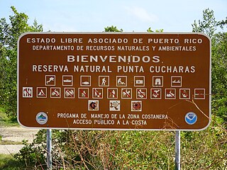
Reserva Natural Punta Cucharas is a nature reserve in Barrio Canas, Ponce, Puerto Rico. It consists of both a land area component as well as an offshore marine area. The land component has an area of 698 cuerdas while the marine component has an expanse of 3,516 cuerdas, for a total area of 4,214 cuerdas. The Reserve consists of mangrove ecosystems, coastal sand dunes, a saline lagoon known as Laguna Las Salinas, open water, and a century-old local community. The lagoon occupies and area of 347,898 m2 Ecological protection is managed and enforced by the Puerto Rico Department of Natural and Environmental Resources. Eight activities are allowed at the Reserve: scuba diving, boating, fishing, hiking, sun bathing, photography, bird watching and canoeing. Activities prohibited are: Camping, crabbing/trapping, horseback riding, water crafting, and hunting. Pets, ATVs, and fireplaces are also prohibited.

Los Morrillos de los Cabos Rojos or more commonly known as Los Morrillos de Cabo Rojo, is a cape and tombolo landform located in southwestern Puerto Rico in the municipality of Cabo Rojo. Los Morrillos is an excellent example of a tombolo, or a tied island, with two sand pits. The cape resembles a letter Y with its two promontories or morrillos being connected through sand pits which enclose a saltwater lagoon. The landform was designated a National Natural Landmark in 1980, and the site includes mangroves, beaches, important bird nesting areas, limestone caves, cliffs and rock formations. The reddish-colored limestone cliffs give the name to the town and municipality of Cabo Rojo.

