
Adjuntas is a small mountainside town and municipality in Puerto Rico located central midwestern portion of the island on the Cordillera Central, north of Yauco, Guayanilla, and Peñuelas; southeast of Utuado; east of Lares and Yauco; and northwest of Ponce. Adjuntas is spread over 16 barrios and Adjuntas Pueblo. Adjuntas is about two hours by car westward from the capital, San Juan.

Utuado is a town and municipality of Puerto Rico located in the central mountainous region of the island known as the Cordillera Central. It is located north of Adjuntas and Ponce; south of Hatillo and Arecibo; east of Lares; and west of Ciales and Jayuya. It is the third-largest municipality in land area in Puerto Rico. According to the 2020 US Census, the municipality has a population of 28,287 spread over 24 barrios and Utuado pueblo.

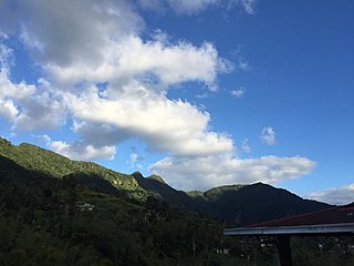
Cordillera Central, is the main mountain range in Puerto Rico. The range crosses the island from west to east and divides it into its northern and southern coastal plains. The Cordillera Central runs eastward from the municipality of Maricao in the west to Aibonito in the central eastern region, and on to the Caribbean in the southeast through the Sierra de Cayey. The Central Mountain Range consists of the Cordillera Central proper and numerous subranges, foothills and ridges that extend throughout the island. Cerro de Punta is both the highest peak of the Cordillera Central and the highest point in Puerto Rico. The Sierra de Luquillo, where El Yunque is located, is sometimes included as a subrange or eastward extension of the Cordillera Central.
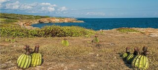
The Guánica State Forest, popularly known as the Guánica Dry Forest is a subtropical dry forest located in southwest Puerto Rico. The area was designated as a forest reserve in 1919 and a United Nations Biosphere Reserve in 1981. It is considered the best preserved subtropical dry forest and the best example of dry forest in the Caribbean.
Maricao State Forest is a state forest located in the eastern Cordillera Central mountains of Puerto Rico. It is commonly known as Monte del Estado due to the fact that it was one of the first forest reserves in Puerto Rico to be designated a state forest in its official name. With an area of 10,803 acres (43.72 km2), the Maricao State Forest is the largest of the 20 forestry units of the Puerto Rico state forest system.
Alexis Massol González is a civil engineer and environmentalist from Puerto Rico. He graduated in civil engineering in University of Puerto Rico at Mayagüez in 1965 and was awarded the Goldman Environmental Prize in 2002 for his efforts on the protection of Puerto Rico's mountain forests due to threats from mining interests. In 1980 he and his wife Tinti Deyá Díaz established Casa Pueblo, a non-profit environmental watchdog community-based organization in Adjuntas. One of the organization's achievements was protecting the forest surrounding their town by establishing Bosque del Pueblo in 1996. It was the first community-managed forest in Puerto Rico. A book he authored, Casa Pueblo: A Puerto Rican Model of Self-Governance, published in 2022, "offers a chronological account of Casa Pueblo’s evolution from a small group of concerned citizens to an internationally recognized model for activism."
Casa Pueblo is a non-profit environmental watchdog community-based organization in Adjuntas, Puerto Rico, headed by Alexis Massol-González, a civil engineer and winner of the 2002 Goldman Environmental Prize. His son, Arturo Massol Deyá, a professor of Microbiology and Ecology at the University of Puerto Rico at Mayagüez, is the assistant executive director of Casa Pueblo.

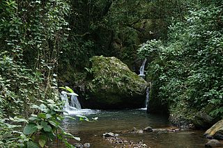
Rio Abajo State Forest is a forest preserve in Puerto Rico owned by the Department of Natural Resources and one of the 20 state forests in the island. It was designated a National Natural Landmark in 1980 and constitutes an area of 3,590 acres. It consists mostly of subtropical wet and moist karst forest. Mogotes and sinkholes fill the landscape. The forest preserve is located in the municipalities of Arecibo and Utuado. In addition to its ecological value the forest also contains a number of archaeological sites.
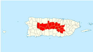
Porta Cordillera is a land-locked tourism region in the central mountainous region of Puerto Rico. It consists of 16 municipalities in the south central zone: Aguas Buenas, Cidra, Cayey, Comerío, Aibonito, Naranjito, Barranquitas, Corozal, Orocovis, Morovis, Ciales, Jayuya, Florida, Utuado, Adjuntas and Lares.

Adjuntas barrio-pueblo is a barrio and the administrative center (seat) of Adjuntas, a municipality of Puerto Rico. Its population in 2010 was 4,406.

The Northern Karst is a limestone karst landscape located in the northern part of Puerto Rico. A karst is a topographical zone formed by the dissolution of soluble porous rocks, such as limestone, with features such as mogotes, canyons, caves, sinkholes, streams and rivers, all of which are common on this region of the island. Some of the island's main rivers, including its longest, traverse the karst and form some of the most distinctive Puerto Rican geographical features such as the Camuy caverns. Many of these rivers feed into and are important in the formation of many marshy areas such as the Caño Tiburones wetlands.

Guilarte State Forest is one of the 20 forests that make up the public forests system in Puerto Rico. The forest is located in the eastern half of the Central Mountain Range or Cordillera Central. The main geographical feature of the forest reserve is Monte Guilarte, which is Puerto Rico's 7th highest mountain at 3,950 feet above sea level. While Monte Guilarte is located in the municipality of Adjuntas, the forest's borders also include parts of Guayanilla, Peñuelas and Yauco.
Los Tres Picachos State Forest is one of the 20 forests that make up the public forest system of Puerto Rico. The forest is located in the Central Mountain Range or Cordillera Central, along the Los Tres Picachos mountain ridge, one of the island's highest mountains, named after the distinctive three peaks of the highest mountain in the forest. The state forest is located in the municipalities of Jayuya and Ciales.

Nuevo Milenio State Forest is one of the 20 forests that make up the public forest system of Puerto Rico. The forest is located east of the University of Puerto Rico Botanical Garden in the Sabana Llana Sur district of San Juan, making it one of the two state forests located within the capital's municipal boundaries.

Guajataca State Forest is one of the 20 forests that make up the public forest system of Puerto Rico. The Guajataca Forest is located in the northwestern part of Puerto Rico, along the Northern Karst zone in the municipality of Isabela and municipality of Quebradillas, and is near Camuy and San Sebastián. The forest is renowned for its ecological diversity, the mogotes and karstic formations, and its numerous caves and canyons. It also has the largest trail system of any Puerto Rican state forest.

Vega State Forest is a state forest of Puerto Rico located in the municipalities of Vega Alta and Vega Baja. The subtropical moist forest is located in the northern coast of Puerto Rico in the middle of the karst zone known as the Carso Norteño, and it contains features typical of such geography such as sinkholes, caves and mogotes. It was designated a nature reserve in 1952 and it is fully protected by the Puerto Rico Forest laws of 1975. The forest has a total area of 1,150 acres divided into six forest units throughout the municipalities of Vega Alta and Vega Baja.

