
El Yunque National Forest, formerly known as the Caribbean National Forest, is a forest located in northeastern Puerto Rico. It is the only tropical rainforest in the United States National Forest System and the United States Forest Service. El Yunque National Forest is located on the slopes of the Sierra de Luquillo mountains, encompassing more than 28,000 acres of land, making it the largest block of public land in Puerto Rico.

Yabucoa is a town and municipality in Puerto Rico located in the eastern region, north of Maunabo; south of San Lorenzo, Las Piedras and Humacao; and east of Patillas. Yabucoa is spread over 9 barrios and Yabucoa Pueblo. It is part of the San Juan-Caguas-Guaynabo Metropolitan Statistical Area.

Maunabo is a town and municipality of Puerto Rico located in the Maunabo Valley on the southeastern coast, northeast of Patillas and south of Yabucoa. Maunabo is spread over eight barrios and Maunabo Pueblo. It is part of the San Juan-Caguas-Guaynabo Metropolitan Statistical Area. The current mayor of the town is Jorge L. Márquez Pérez and the population in 2020 was 10,589.
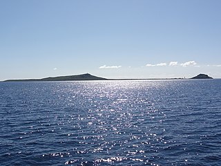
Caja de Muertos is an uninhabited island off the southern coast of Puerto Rico, in the municipality of Ponce. The island and its surrounding waters are protected by the Caja de Muertos Nature Reserve, because of its native turtle traffic and ecological value of its dry forests and reefs. Hikers and beachgoers are often seen in the island, which can be reached by ferry from the La Guancha Boardwalk sector of Ponce Playa. Together with Cardona, Ratones, Morrillito, Isla del Frio, Gatas, and Isla de Jueyes, Caja de Muertos is one of seven islands ascribed to the municipality of Ponce.
The Conservation Trust of Puerto Rico is a private, nonprofit organization protecting natural areas; constituting conservation easements; restoring, rehabilitating and preserving historical structures; developing educational programs that foster the protection of natural areas; and directing a tree nursery program for native and endemic species, among others. The Conservation Trust of Puerto Rico has been accredited by The Land Trust Accreditation Commission. The Conservation Trust is also a member of the International Union for Conservation of Nature, a global environmental organization with more than 1,200 public and private members from 160 countries.

Toro Negro State Forest is one of the 21 forests that make up the public forests system in Puerto Rico. It is also Puerto Rico's highest cloud forest. It is in the Cordillera Central region of the island and covers 8,204 cuerdas, of mountains. Toro Negro's mountains have heights reaching up to 4,400 feet (1,300 m) and include Cerro de Punta, Cerro Jayuya and Cerro Rosa, the three highest peaks in the island. Nested among these mountains is Lake Guineo, the island's highest lake. The forest has 18 kilometers (11 mi) of trails, an observation tower, two natural swimming pools (Spanish:"charcos"), camping and picnic areas, nine rivers, and numerous creeks and waterfalls. The forest spans areas within the municipalities of Ponce, Jayuya, Orocovis, Ciales, and Juana Díaz, and consists of seven non-contiguous tracts of land. The largest contiguous segment of the forest is located in the municipalities of Ponce and Jayuya. Some 40% of the area of Toro Negro State Forest is located in Ponce's Barrio Anón.

The Northeast Ecological Corridor Nature Reserve (NECNR) refers to an area designated as a protected Nature Reserve located on the northeast coast of Puerto Rico, between the municipalities of Luquillo and Fajardo. Specifically, the lands that comprise the NEC are located between Luquillo's town square to the west and Seven Seas Beach to the east, being delineated by PR Route # 3 to its south and the Atlantic Ocean to its north. It was decreed as a protected area by former Puerto Rico Governor Aníbal S. Acevedo-Vilá in April 2008, a decision reversed by Governor Luis G. Fortuño-Burset in October 2009, although he later passed a law in June 2012 re-designated as nature reserve two-thirds of its lands, after intense lobbying and public pressure. Later, in 2013, Governor Alejandro García-Padilla signed a law declaring all lands within the NEC a nature reserve. The area comprises 2,969.64 acres, which include such diverse habitats as forest, wetlands, beaches, coral communities, and a sporadically bioluminescent lagoon. The Corridor is also home to 866 species of flora and fauna, of which 54 are considered critical elements, meaning rare, threatened, endangered and endemic species classified by the Puerto Rico Department of Natural and Environmental Resources (DNER), some even designated as critically endangered by the International Union for Conservation of Nature and Natural Resources (IUCN). These include, among others, federally endangered species such as the plain pigeon, the snowy plover, the Puerto Rican boa, the hawksbill sea turtle and the West Indian manatee. The beaches along the NEC, which are 8.74 kilometers long are important nesting grounds for the leatherback sea turtle, which starts its nesting season around April each year.
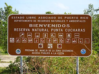
Reserva Natural Punta Cucharas is a nature reserve in Barrio Canas, Ponce, Puerto Rico. It consists of both a land area component as well as an offshore marine area. The land component has an area of 698 cuerdas while the marine component has an expanse of 3,516 cuerdas, for a total area of 4,214 cuerdas. The Reserve consists of mangrove ecosystems, coastal sand dunes, a saline lagoon known as Laguna Las Salinas, open water, and a century-old local community. The lagoon occupies and area of 347,898 m2 Ecological protection is managed and enforced by the Puerto Rico Department of Natural and Environmental Resources. Eight activities are allowed at the Reserve: scuba diving, boating, fishing, hiking, sun bathing, photography, bird watching and canoeing. Activities prohibited are: Camping, crabbing/trapping, horseback riding, water crafting, and hunting. Pets, ATVs, and fireplaces are also prohibited.

Carite State Forest is a state forest and nature reserve located in the Sierra de Cayey mountain range in southeastern Puerto Rico. The forest extends over approximately 6,500 acres and is located in the municipalities of Caguas, Cayey, Guayama, Patillas and San Lorenzo. The forest is located along the Ruta Panorámica, which offers access to the forest.
Caño Tiburones is a wetland and nature reserve located in the northern coast of Puerto Rico in the municipalities of Arecibo and Barceloneta. This is one of the largest wetlands in Puerto Rico, covering almost 7,000 acres. A large portion of the swamp, located in Arecibo, is protected as the Caño Tiburones Nature Reserve.

Humacao Nature Reserve, or the Punta Santiago Nature Reserve, is a nature reserve located in the southeastern coast of Puerto Rico, between the municipalities of Humacao and Naguabo (Río). The 3,000-acre nature reserve was established in 1986 to protect and preserve the remaining Pterocarpus forest ecosystem in the area, along with its surrounding wetlands and mangrove forests.
The Aguas Buenas Cave System is a cave system located in the municipality of Aguas Buenas. The caves and their surrounding forest area are protected by the almost 1,800-acre Aguas Buenas Cave and Caverns System Nature Reserve since 2002, which also extends to the municipalities of Caguas and Cidra. The reserve is important for the number of bat species found in the system, some of which are endangered. In addition to being an important bat preserve, the nature reserve protects an important hydrological basin which is the source of a number of rivers and creeks that form part of the Loíza River basin.
Sierra de Jájome is a mountain massif of the Sierra de Cayey located in the municipalities of Cayey, Guayama and Salinas in southeastern Puerto Rico. The mountain, often referred to as a mountain range (sierra), is protected as the Jájome Protected Natural Area. The Guayama Research Forest Area is also located on the massif. La Robleda, another protected natural area, is located nearby.
The Planadas-Yeyesa Nature Reserve is a protected nature reserve located in the Sierra de Cayey, in the municipality of Salinas in central Puerto Rico. The reserve is located close to the famous Cerro Las Tetas. Two of the most prominent features of the reserve are Cerro Planada, a 2,480 feet high mountain peak, and La Yeyesa, a heavily forested canyon formed by the Lapa River and other streams which feed into the Nigua River. La Yeyesa can be accessed through a lightly trafficked yet moderate trail.

Caja de Muertos Nature Reserve is a nature reserve in southern Puerto Rico consisting of the islands of Caja de Muertos, Cayo Morrillito, Cayo Berbería, and their surrounding reefs and waters in the Caribbean Sea. This nature reserve was founded on January 2, 1980, by the Puerto Rico Planning Board as recommended by the Puerto Rico Department of Natural and Environmental Resources with the purpose of preserving the subtropical dry forest ecosystems found within these islands, some important sea turtle nesting sites, and the marine habitats found on their surrounding reefs and waters.

La Robleda Natural Protected Area is a 254-acre protected natural area and conservation easement in Cayey, Puerto Rico. La Robleda, meaning 'the oak grove', gets its name from the high concentration of pink manjack trees, locally known as roble blanco, in the area. The pink manjack trees in this nature reserve bloom for a few weeks every year, creating a natural scenic spectacle of pink and white colors in the Sierra de Cayey.
Cibuco Swamp is a swamp located in northern Puerto Rico in the municipality of Vega Baja. The swamp is found at the mouth of the Cibuco River, in the barrios Cabo Caribe, Cibuco and Puerto Nuevo. The swamp is protected by the Puerto Rico Department of Natural and Environmental Resources (DRNA) as the Cibuco Swamp Nature Reserve, and it is home to a large number of species of plants and animals. The nature reserve is open to visitors who are allowed to hike and bike, and the area is also popular for birdwatching.

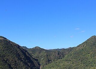
Sierra Pandura, also known as Cuchilla de Pandura and La Pica, is a mountain range that runs from the Sierra de Cayey in the northwest to the Caribbean Sea in the southeast in southeastern Puerto Rico, between the municipalities of Maunabo and Yabucoa. Together with the Sierra de Guardarraya to the south, Sierra Pandura is part of the San Lorinzo batholith physiological region, a composite body of volcanic origin which bifurcates the mountain ridge.

Isla Verde Reef is a reef that surrounds Isla Verde Key, located off the coast of Punta del Medio in Isla Verde, Carolina, in the Atlantic coast of Puerto Rico. The Isla Verde Reef, protected as the Isla Verde Reef Marine Reserve, forms part of a larger reef system that extends from Punta Maldonado in Piñones, Loíza to the San Juan Islet. This is one of the three designated marine reserves in Puerto Rico, the other two being the Desecheo Coastal Waters and Tres Palmas marine reserves off the western coast of Puerto Rico, and the only one that protects a coral reef ecosystem on an urban area. The reserve is home to endangered species such as manatees, sea turtles and federally protected coral species such as the elkhorn coral. The coral reef is also an ideal place for fish spawning which is important for the fishing industry of the region. The Isla Verde Reef is protected through community organizations such as Arrecifes Pro Ciudad, and public organisms such as Para la Naturaleza, with support from academic institutions such as the University of Puerto Rico at Bayamón.

