Maunabo is a town and municipality of Puerto Rico located in the Maunabo Valley on the southeastern coast, northeast of Patillas and south of Yabucoa. Maunabo is spread over eight barrios and Maunabo Pueblo. It is part of the San Juan-Caguas-Guaynabo Metropolitan Statistical Area. The current mayor of the town is Jorge L. Márquez Pérez and the population in 2020 was 10,589.

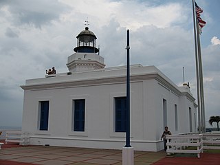
Faro Los Morrillos de Cabo Rojo, also known as Los Morrillos Light, is a historic lighthouse located in Los Morrillos cape in the municipality of Cabo Rojo, Puerto Rico.
The Conservation Trust of Puerto Rico is a private, nonprofit organization protecting natural areas; constituting conservation easements; restoring, rehabilitating and preserving historical structures; developing educational programs that foster the protection of natural areas; and directing a tree nursery program for native and endemic species, among others. The Conservation Trust of Puerto Rico has been accredited by The Land Trust Accreditation Commission. The Conservation Trust is also a member of the International Union for Conservation of Nature, a global environmental organization with more than 1,200 public and private members from 160 countries.

Cape San Juan Light is a historic lighthouse located on the northeastern part of the highest point of Cape San Juan in Fajardo, Puerto Rico. The lighthouse was constructed in 1880 and was officially lit on May 2, 1882. The original illuminating apparatus, not changed until after 1898, had an 18-mile (29 km) range and displayed a fixed white light which every three minutes flashed red.
Arecibo Lighthouse & Historical Park is a historic lighthouse located in the city of Arecibo, Puerto Rico. It is also known as Los Morrillos Lighthouse and is as a monument to Puerto Rico's complex history under Spanish colonial rule. Perched atop the Punta Morrillos headland since 1898, this iconic lighthouse was the last constructed under Spain's 300-year presence on the island. Despite the collapse of the Spanish Empire following the Spanish-American war that same year, the Arecibo Lighthouse endured.

Punta Higuero Lighthouse, also known as Faro de Punta Higuero, is an historic lighthouse located in Rincón, Puerto Rico. The original building was built in 1892 by the Spanish government and was rebuilt in 1922 by the United States Coast Guard.

Punta de las Figuras Light is an historic lighthouse located in Arroyo, Puerto Rico. It was first lit by the Spanish government in 1893. The light was relocated in 1938, and the structure was deactivated and abandoned. During World War II, the lighthouse was used as a lookout. After the U.S. Army abandoned the structure in 1963, the lighthouse was repeatedly vandalized. In 1969 the lens and lantern were destroyed. The lighthouse was again damaged by Hurricane Maria on September 20, 2017. The light housing is broken, all of the windows are boarded up, and several of the surrounding light pole fixtures are downed. The interior is currently inaccessible.

Cardona Island Light is the only 6th order lighthouse in Puerto Rico with a cylindrical attached tower. The light is located on Cardona Island, a small island on the west side of the entrance to the harbor of Ponce, Puerto Rico. It was listed in the U.S. National Register of Historic Places on 22 October 1981 and on the Puerto Rico Register of Historic Sites and Zones in 2001.

Punta Mulas Light, also known as Faro de Vieques, is a historic lighthouse located in the north shore of Vieques, an island-municipality of Puerto Rico. It was first lit in 1896 and automated in 1949. Punta Mulas Light was the second lighthouse built on Vieques after the Puerto Ferro Light. The light was established to guide through the dangerous passage formed by a chain of reefs. It was of key importance for navigation in the San Juan Passage.
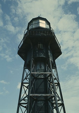
Mona Island Light, also known as Faro de la Isla de la Mona, is a historic lighthouse located on the island of Mona, Puerto Rico, in the Mona Passage between Puerto Rico and the Dominican Republic. It is the only lighthouse built of iron and steel in Puerto Rico. While some sources reported that the structure was designed by Gustav Eiffel, who also designed the Eiffel Tower in Paris, recent studies have shown that the tower was designed around 1885 by Spanish engineer Rafael Ravena.

Guánica Light was a historic lighthouse located in the municipality of Guánica, Puerto Rico in the Guánica State Forest. It was first lit in 1893 and deactivated in 1950. The light marked the entrance to Guánica Bay and bridge the gap between Los Morrillos Light and Caja de Muertos Light.

Punta Borinquen Light is a lighthouse located in the old Ramey Air Force Base in Aguadilla, Puerto Rico. The station was established in 1889 by the Spanish government. With the opening of the Panama Canal in 1914, the lighthouse would become "the most important aid to navigation on the route from Europe to Panama". In 1917, the U.S Congress provided funding for a new lighthouse in higher ground.
Cueva de Los Indios, also known as the Cueva Punta Maldonado site, in the municipality of Loíza, Puerto Rico, was listed on the National Register of Historic Places in 1982, and on the Puerto Rico Register of Historic Sites and Zones in 2000.
Paseo Víctor Rojas, also known as El Fuerte or Paseo de Damas, in Arecibo, Puerto Rico, was built in 1881. It was listed on the National Register of Historic Places in 1986, and on the Puerto Rico Register of Historic Sites and Zones in 2000.

The Hermitage of San Antonio de Padua de la Tuna is an archaeological site located near the Guajataca River in Coto, Isabela, Puerto Rico, dating from 1730. It comprises the ruins of a village church that was abandoned in the early 19th century when the community, with the permission of Governor Salvador Meléndez, moved to a more favorable location nearer the coast, which became the modern town of Isabela, founded in 1819.

Culebrita Lighthouse is the only remaining Spanish-era structure in the Culebra archipelago. Construction of the lighthouse began on September 25, 1882, and was completed on February 25, 1886. The Spanish Crown built the lighthouse to help secure its claim over the main island of Culebra. It is the most eastern light outside mainland Puerto Rico. It guided navigation through the Virgin Passage and the Vieques Sound connecting in the Puerto Rico Light System with the Cape San Juan Light.

The Hondo River Bridge was a historic bridge over the Hondo River in Comerío municipality, Puerto Rico. As of 1995, it was the oldest bridge truss in Puerto Rico, employing a double Warren pony truss design and unique open web transverse joists. It was originally installed in 1881 as one of three spans of the Reyes Católicos Bridge over the Plata River on the San Juan–Mayagüez road, using metal parts fabricated in Belgium. After a hurricane destroyed one of the other spans of the Reyes Católicos Bridge in 1899, this surviving span was moved and re-installed on new abutments under the supervision of engineer Rafael Nones in 1908, as part of the Comerío–Barranquitas road. It was finally removed and replaced in 2001.

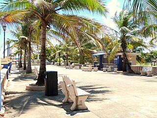
Punta Santiago is a barrio and fishing community located in the municipality of Humacao, Puerto Rico. Its population in 2020 was 3,716. Located in the estuary of Humacao, Punta Santiago is famous for its fishing heritage, its iconic pier and Cayo Santiago, popularly known as Monkey Island after its Rhesus macaque population. The barrio is also the home of the Humacao Nature Reserve and the Punta Santiago Beach and Vacation Area. Punta Santiago is one of the most vulnerable barrios to flooding and complete destruction whenever hurricanes enter Puerto Rico through the area of Humacao.

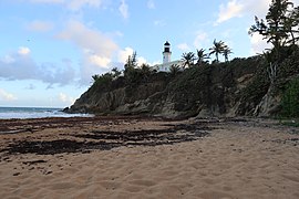
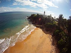
Puerto Rico Highway 760 (PR-760) is a rural road located in Maunabo, Puerto Rico. It begins at its intersection with PR-3 near downtown Maunabo and ends at Punta Tuna Light.