
Cabo Rojo is a city and municipality situated on the southwest coast of Puerto Rico and forms part of the San Germán–Cabo Rojo metropolitan area as well as the larger Mayagüez–San Germán–Cabo Rojo Combined Statistical Area.

Puerto Rico Highway 301 (PR-301) is a main highway in Cabo Rojo, Puerto Rico. It begins in PR-101, close to PR-100, and goes south all the way to Los Morrillos Light, where it ends. It is the main access to the lighthouse, the Cabo Rojo cliffs, and Playa Sucia.

Cabo Rojo National Wildlife Refuge is an 1,836-acre National Wildlife Refuge located in southwestern Puerto Rico, in the municipality of Cabo Rojo. The refuge is a habitat for number of native bird species including the endangered yellow-shouldered blackbird, locally known as mariquita de Puerto Rico or capitán. Many birds find their way to the refuge while migrating between North and South America, and more than 118 bird species have been recorded near the area.

Cape San Juan Light is a historic lighthouse located on the northeastern part of the highest point of Cape San Juan in Fajardo, Puerto Rico. The lighthouse was constructed in 1880 and was officially lit on May 2, 1882. The original illuminating apparatus, not changed until after 1898, had an 18-mile (29 km) range and displayed a fixed white light which every three minutes flashed red.
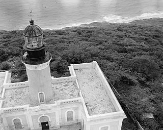
Arecibo Lighthouse & Historical Park is a historic lighthouse located in the city of Arecibo, Puerto Rico. It is also known as Los Morrillos Lighthouse and is as a monument to Puerto Rico's complex history under Spanish colonial rule. Perched atop the Punta Morrillos headland since 1898, this iconic lighthouse was the last constructed under Spain's 300-year presence on the island. Despite the collapse of the Spanish Empire following the Spanish-American war that same year, the Arecibo Lighthouse endured.

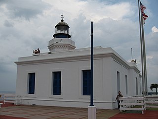
Punta Higüero Light is a historic lighthouse located in the municipality of Rincón on the westernmost point, known as Punta Higüero, in the main island of Puerto Rico. The original building was built in 1892 by the Spanish government and was rebuilt in 1922 by the United States Coast Guard.

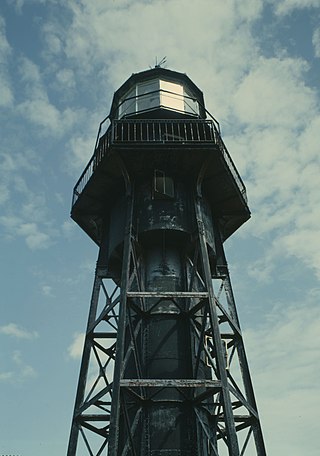
Punta de las Figuras Light is an historic lighthouse located in Arroyo, Puerto Rico. It was first lit by the Spanish government in 1893. The light was relocated in 1938, and the structure was deactivated and abandoned. During World War II, the lighthouse was used as a lookout. After the U.S. Army abandoned the structure in 1963, the lighthouse was repeatedly vandalized. In 1969 the lens and lantern were destroyed. The lighthouse was again damaged by Hurricane Maria on September 20, 2017. The light housing is broken, all of the windows are boarded up, and several of the surrounding light pole fixtures are downed. The interior is currently inaccessible.

Cardona Island Light is the only 6th order lighthouse in Puerto Rico with a cylindrical attached tower. The light is located on Cardona Island, a small island on the west side of the entrance to the harbor of Ponce, Puerto Rico. It was listed in the U.S. National Register of Historic Places on 22 October 1981 and on the Puerto Rico Register of Historic Sites and Zones in 2001.

Punta Tuna Light is a historic lighthouse located in the southeast of the town of Maunabo, Puerto Rico on a narrow promontory at the southeasternmost point of the island.

Punta Mulas Light, also known as Faro de Vieques, is a historic lighthouse located in the north shore of Vieques, an island-municipality of Puerto Rico. It was first lit in 1896 and automated in 1949. Punta Mulas Light was the second lighthouse built on Vieques after the Puerto Ferro Light. The light was established to guide through the dangerous passage formed by a chain of reefs. It was of key importance for navigation in the San Juan Passage.
Mona Island Light, also known as Faro de la Isla de la Mona, is a historic lighthouse located on the island of Mona, Puerto Rico, in the Mona Passage between Puerto Rico and the Dominican Republic. It is the only lighthouse built of iron and steel in Puerto Rico. While some sources reported that the structure was designed by Gustav Eiffel, who also designed the Eiffel Tower in Paris, recent studies have shown that the tower was designed around 1885 by Spanish engineer Rafael Ravena.
Caja de Muertos Light, is an 1887 lighthouse in Ponce, Puerto Rico, that is unique amongst all other lighthouses in Puerto Rico for its unusual Cross of Lorraine, double-arm, T-type shape structure. The historic lighthouse is located on Caja de Muertos, an uninhabited island off the coast of Ponce, Puerto Rico. The light stands at the highest point of the island.

Guánica Light was a historic lighthouse located in the municipality of Guánica, Puerto Rico in the Guánica State Forest. It was first lit in 1893 and deactivated in 1950. The light marked the entrance to Guánica Bay and bridged the gap between Los Morrillos Light and Caja de Muertos Light.

Punta Borinquén Light is a historic lighthouse located in the municipality of Aguadilla on the northwestern corner, known as Punta Borinquén, of the main island of Puerto Rico. Situated on the grounds of the former Ramey Air Force Base, the station was established in 1889 by the Spanish government. With the opening of the Panama Canal in 1914, the lighthouse would become "the most important aid to navigation on the route from Europe to Panama". In 1917, the U.S Congress provided funding for a new lighthouse in higher ground.

Puerto Ferro Light, also known as Faro de Puerto Ferro, is a historic lighthouse located in the Vieques, Puerto Rico. The light was first lit in 1896. It is one of the last minor or local lights to be built by the Spanish government. The light was of crucial importance to cross the Vieques Passage. The lighthouse was deactivated in 1926 when it was abandoned.

Isla Cabras Light, also known as Faro de Isla Cabras, was a lighthouse located on a rocky but flat islet with the same name, which sit just off the coast near Ceiba, Puerto Rico, toward the Vieques Passage.

Culebrita Lighthouse is the only remaining Spanish-era structure in the Culebra archipelago. Construction of the lighthouse began on September 25, 1882, and was completed on February 25, 1886. The Spanish Crown built the lighthouse to help secure its claim over the main island of Culebra. It is the most eastern light outside mainland Puerto Rico. It guided navigation through the Virgin Passage and the Vieques Sound connecting in the Puerto Rico Light System with the Cape San Juan Light.

Boquerón State Forest is one of the 20 forestry units that make up the public forest system of Puerto Rico. Despite its name, the Boquerón State Forest is not only located in Boquerón, Cabo Rojo but also spans almost 5,000 acres across the municipalities of Cabo Rojo, Lajas and Mayagüez. The forest area is also known for its limestone cliffs, the lighthouse, and the salt flats which have been a source of salt since the pre-Hispanic era and, dating to 700 C.E., they are considered to be one of the oldest industries in the Americas.

Los Morrillos de los Cabos Rojos or more commonly known as Los Morrillos de Cabo Rojo, is a cape and tombolo landform located in southwestern Puerto Rico in the municipality of Cabo Rojo. Los Morrillos is an excellent example of a tombolo, or a tied island, with two sand pits. The cape resembles a letter Y with its two promontories or morrillos being connected through sand pits which enclose a saltwater lagoon. The landform was designated a National Natural Landmark in 1980, and the site includes mangroves, beaches, important bird nesting areas, limestone caves, cliffs and rock formations. The reddish-colored limestone cliffs give the name to the town and municipality of Cabo Rojo.


