National Register of Historic Places listings in northern Puerto Rico

Last updated
National Register entries listed below are found in the highlighted 17 municipalities of Puerto Rico. NRHP list - northern PR.png
National Register entries listed below are found in the highlighted 17 municipalities of Puerto Rico.

This portion of National Register of Historic Places listings in Puerto Rico is along the north coast, north plains, and north slopes of the Cordillera, from Isabela to Guaynabo.

Contents

Map all coordinates using: OpenStreetMap

Names of places given are as appear in the National Register, reflecting name as given in NRHP application at the date of listing. Note, the National Register name system does not accommodate Spanish á, ñ and other letters.


    This National Park Service list is complete through NPS recent listings posted September 29, 2023. [1]

Arecibo

[2] Name on the RegisterImageDate listed [3] Location BarrioDescription
1 Calle Gonzalo Marín No. 61
Calle Gonzalo Marin No. 61 Calle Gonzalo Marin No. 61.jpg
Calle Gonzalo Marín No. 61
October 19, 1986
(#88000645)
61 Gonzalo Marín Street
18°28′19″N66°42′54″W / 18.4719°N 66.7149°W / 18.4719; -66.7149 (Calle Gonzalo Marín No. 61)
Arecibo PuebloTraditional Spanish Colonial-style residence building from before 1860. Also known as the Abreu Residence.
2 Cambalache Bridge
Cambalache Bridge Cambalache Bridge.jpg
Cambalache Bridge
July 19, 1995
(#95000831)
Spanning Río Grande de Arecibo, west of Puerto Rico Highway 2
18°27′13″N66°42′09″W / 18.4535°N 66.7024°W / 18.4535; -66.7024 (Cambalache Bridge)
Cambalache and TanamáSteel bridge built by the Puerto Rico Railway Company in 1893 spanning the Arecibo River as a connector between San Juan and Arecibo. Also known as the French Bridge.
3 Casa Alcaldía de Arecibo
Casa Alcaldia de Arecibo Casa Alcaldia, Arecibo, Puerto Rico - panoramio.jpg
Casa Alcaldía de Arecibo
September 29, 1986
(#86002762)
José de Diego Avenue
18°28′21″N66°42′56″W / 18.4725°N 66.7155°W / 18.4725; -66.7155 (Casa Alcaldía de Arecibo)
Arecibo PuebloThe city hall of Arecibo, built between 1850 and 1866 in a Classical Revival style.
4 Casa Córdova
Casa Cordova Casa Cordova 1 - Arecibo Puerto Rico.jpg
Casa Córdova
November 17, 1986
(#86003185)
14 Gonzalo Marín Street
18°28′21″N66°42′49″W / 18.4725°N 66.7135°W / 18.4725; -66.7135 (Casa Córdova)
Arecibo PuebloHistoric mix-use commercial and residential building from 1898 with architecture inspired in the Neoclassical and Beaux Arts styles. Also known as Casa de las Conchas.
5 Casa de la Diosa Mita
Casa de la Diosa Mita Casa de la Diosa Mita 1 - Arecibo Puerto Rico.jpg
Casa de la Diosa Mita
September 9, 1988
(#88000966)
251 Fernández Juncos Street
18°28′17″N66°43′09″W / 18.4715°N 66.7191°W / 18.4715; -66.7191 (Casa de la Diosa Mita)
Arecibo PuebloA now-ruined Beaux Arts house and former residence of the self-professed goddess Juanita García Peraza, founder of the Mita Congregation.
6 Casa Ulanga
Casa Ulanga Casa Ulanga - Arecibo Puerto Rico.jpg
Casa Ulanga
July 26, 1982
(#82003822)
7 Gonzalo Marín Street
18°28′21″N66°42′46″W / 18.4725°N 66.7128°W / 18.4725; -66.7128 (Casa Ulanga)
Arecibo PuebloFormer Superior Court of Arecibo used throughout its history as a bank, store, city hall of Arecibo, hospital, jail and cultural center.
7 Corregimiento Plaza Theater
Corregimiento Plaza Theater Teatro Oliver, Arecibo, Puerto Rico - panoramio.jpg
Corregimiento Plaza Theater
January 6, 1986
(#86000041)
Llaguerry and Toribio Pagán Streets
18°28′22″N66°42′55″W / 18.4729°N 66.7153°W / 18.4729; -66.7153 (Corregimiento Plaza Theater)
Arecibo Pueblo Classical Revival-style theater from 1876. Also known as the Oliver Theater.
8 Edificio Oliver
Edificio Oliver Edificio Oliver.jpg
Edificio Oliver
October 1, 1986
(#86002764)
64 José de Diego Avenue
18°28′21″N66°42′55″W / 18.4726°N 66.7152°W / 18.4726; -66.7152 (Edificio Oliver)
Arecibo Pueblo Beaux Arts-style building formerly used as a Casa del Rey, courthouse and school. Now used as a municipal office building.
9 Faro de Arecibo
Faro de Arecibo Faro de Punta los Morrillos.jpg
Faro de Arecibo
November 23, 1977
(#77001546)
Punta Morillos, Highway 655
18°28′55″N66°41′55″W / 18.4820°N 66.6987°W / 18.4820; -66.6987 (Faro de Arecibo)
Arecibo PuebloSpanish-built Neoclassical lighthouse from 1898, the last one to be built by Spain before the Spanish-American War. Part of the Lighthouse System of Puerto Rico TR.
10 Federico Degetau Consolidated Rural School
Federico Degetau Consolidated Rural School Schoolhouse for Consolidated Rural Schools, Barrio Santana, Arecibo, Puerto Rico (1920) - photograph - page 148.jpg
Federico Degetau Consolidated Rural School
May 26, 2020
(#100005236)
Carretera #662 Km. 68
18°26′45″N66°39′55″W / 18.445834°N 66.665416°W / 18.445834; -66.665416 (Federico Degetau Consolidated Rural School)
SantanaHistoric school building for primary and secondary education in the rural Santana barrio of Arecibo.
11 Gonzalo Marín 101
Gonzalo Marin 101 Gonzalo Marin 101 2 - Arecibo Puerto Rico.jpg
Gonzalo Marín 101
November 19, 1986
(#86003183)
101 Gonzalo Marín Street
18°28′18″N66°42′56″W / 18.4718°N 66.7155°W / 18.4718; -66.7155 (Gonzalo Marín 101)
Arecibo PuebloOne of the oldest purpose-built bank buildings in the region, designed in a Spanish Neoclassical style. Popularly known as the Old Citibank Building.
12 National Astronomy and Ionosphere Center
National Astronomy and Ionosphere Center Arecibo radio telescope observatory Puerto Rico - panoramio (11).jpg
National Astronomy and Ionosphere Center
September 23, 2008
(#07000525)
Highway 625, San Rafael Sector
18°20′45″N66°45′10″W / 18.3457°N 66.7527°W / 18.3457; -66.7527 (National Astronomy and Ionosphere Center)
Esperanza Observatory complex consisting of radio telescopes and a LIDAR facility, most notably the Arecibo Telescope, a large spherical reflector built into a sinkhole in the middle of the Northern Puerto Rico karst region, formerly the largest of its kind in the world.
13 Palacio del Marqués de las Claras
Palacio del Marques de las Claras Palacio del Marques de las Claras 1 - Arecibo Puerto Rico.jpg
Palacio del Marqués de las Claras
July 12, 1988
(#88000964)
58 Gonzalo Marín Street
18°28′20″N66°42′53″W / 18.4723°N 66.7146°W / 18.4723; -66.7146 (Palacio del Marqués de las Claras)
Arecibo Pueblo Neoclassical urban mansion built in 1888 for Fernando Fernández Umpierre, Marquis de las Claras, a wealthy owner of sugarcane plantations. Formerly served as the Casino of Arecibo and currently used as an event venue.
14 Paseo Víctor Rojas
Paseo Victor Rojas Paseo las Damas in4 - Arecibo Puerto Rico.jpg
Paseo Víctor Rojas
November 19, 1986
(#86003188)
Gonzalo Marín Street at José de Diego Avenue
18°28′22″N66°42′42″W / 18.4727°N 66.7118°W / 18.4727; -66.7118 (Paseo Víctor Rojas)
Arecibo PuebloRectangular promenade designed in a Neoclásico Isabelino-style and built in 1881 at the site of a former Spanish fort. Also known as the Paseo de Damas.
15 Franklin Delano Roosevelt Graded School February 8, 2021
(#100006152)
Calle Oriente No. 218
18°28′18″N66°43′09″W / 18.4716°N 66.7192°W / 18.4716; -66.7192 (Franklin Delano Roosevelt Graded School)
Arecibo vicinityHistoric Art Deco style school built in 1938 on top of a hill in downtown Arecibo at the site of a former hermitage.

Barceloneta

[2] Name on the RegisterImageDate listed [3] Location BarrioDescription
1 Rafael Balseiro Maceira School
Rafael Balseiro Maceira School Escuela Rafael Balseiro Maceira de Barceloneta..JPG
Rafael Balseiro Maceira School
August 28, 2012
(#12000583)
1 Georgetti Street
18°27′09″N66°32′20″W / 18.452597°N 66.538794°W / 18.452597; -66.538794 (Rafael Balseiro Maceira School)
Barceloneta Pueblo Example of the Late 19th And Early 20th Century AmericanPrairie School, Eclectic architecture movements, part of the Early Twentieth Century Schools in Puerto Rico Thematic Resource (TR).

Bayamón

[2] Name on the RegisterImageDate listed [3] Location BarrioDescription
1 Casa Dr. Agustín Stahl Stamm
Casa Dr. Agustin Stahl Stamm Casa Stahl.jpg
Casa Dr. Agustín Stahl Stamm
February 4, 2011
(#10001216)
14 José Martí St.
18°23′56″N66°09′19″W / 18.398781°N 66.155200°W / 18.398781; -66.155200 (Casa Dr. Agustín Stahl Stamm)
Bayamón Pueblo This 1840s house was the residence and laboratory of internationally recognized scientist Agustín Stahl (1842–1917) [lower-alpha 1] from 1865 until his death. Despite a modest physician's income, Stahl published important works in zoology, botany, medicine, agriculture, ethnology, demography, and history, and led public health campaigns across Puerto Rico. [4]
2 Casa Natal Dr. José Celso Barbosa
Casa Natal Dr. Jose Celso Barbosa House of Jose Celso Barbosa.jpg
Casa Natal Dr. José Celso Barbosa
August 24, 1984
(#84003156)
16 Barbosa St.
18°23′57″N66°09′16″W / 18.399036°N 66.154480°W / 18.399036; -66.154480 (Casa Natal Dr. José Celso Barbosa)
Bayamón Pueblo House from 1850, associated with physician and sociologist José Celso Barbosa, known as the father of the Puerto Rico statehood movement. Now owned by the Institute of Puerto Rican Culture and operated as a historic house museum.
3 Church Santa Cruz of Bayamón
Church Santa Cruz of Bayamon Church Santa Cruz of Bayamon.jpg
Church Santa Cruz of Bayamón
September 18, 1984
(#84003162)
Plaza de Hostos
18°23′56″N66°09′21″W / 18.398796°N 66.155821°W / 18.398796; -66.155821 (Church Santa Cruz of Bayamón)
Bayamón Pueblo Historic parish church from 1772, built atop a hill known as Alto del Embarcadero around which the modern city of Bayamón was developed.
4 Farmacia Serra May 4, 1989
(#88000685)
11 Degetau St.
18°23′57″N66°09′20″W / 18.399238°N 66.155442°W / 18.399238; -66.155442 (Farmacia Serra)
Bayamón Pueblo Eclectic Rennaissance Revival residential and commercial mixed-use building from 1910 that housed the first store of the Serra drugstore chain.
5 Marqués de la Serna Bridge
Marques de la Serna Bridge Puente Marques de la Serna, Bayamon, Puerto Rico.jpg
Marqués de la Serna Bridge
July 19, 1995
(#95000850)
Highway 890, km 24.1
18°24′10″N66°09′21″W / 18.402705°N 66.155924°W / 18.402705; -66.155924 (Marqués de la Serna Bridge)
Juan Sánchez and Bayamón Pueblo A well-preserved rolled iron segmented arch bridge and the only one of its kind in Puerto Rico. Also known as the Bayamón Bridge or Bridge No. 379.
6 Plata Bridge
Plata Bridge Puente La Plata desde Bayamon.jpg
Plata Bridge
July 19, 1995
(#95000849)
Highway 167, km 0.9
18°18′14″N66°12′41″W / 18.30384°N 66.21132°W / 18.30384; -66.21132 (Plata Bridge)
Dajaos and Nuevo [lower-alpha 2] Bridge built to span La Plata River in 1908 consisting of two Parker truss spans, the only of its kind in Puerto Rico.
7 Puerto Rico National Cemetery
Puerto Rico National Cemetery Puerto Rico National Cemetery.jpg
Puerto Rico National Cemetery
September 26, 1983
(#83002298)
Highway 168
18°24′44″N66°10′00″W / 18.412222°N 66.166667°W / 18.412222; -66.166667 (Puerto Rico National Cemetery)
Hato Tejas The only United States national cemetery outside of mainland U.S., established 1948 at a mogote-surrounded site surrounded formerly owned by the United States Navy.

Camuy

[2] Name on the RegisterImageDate listed [3] Location BarrioDescription
1 Antiguo Casino Camuyano
Antiguo Casino Camuyano Antiguo Casino Camuyano - Camuy Puerto Rico.jpg
Antiguo Casino Camuyano
January 26, 1984
(#84003123)
Estrella and Muñoz Rivera Streets
18°29′03″N66°50′42″W / 18.484134°N 66.845010°W / 18.484134; -66.845010 (Antiguo Casino Camuyano)
Camuy Pueblo Classical Revival-style reinforced concrete building from 1910 that served as both a casino and as an event building
2 Ernesto Memorial Chapel
Ernesto Memorial Chapel Iglesia de Piedra -1 (4846220868).jpg
Ernesto Memorial Chapel
July 8, 2010
(#10000453)
Intersection of Highway 486 and Highway 488
18°25′59″N66°51′16″W / 18.432953°N 66.854555°W / 18.432953; -66.854555 (Ernesto Memorial Chapel)
Abra Honda American Craftsman-style Methodist chapel from 1912 designed by Albert Munson and built as a memorial for Ernesto Kiplinger. Popularly known as la Iglesia de Piedra (the Stone Church).
3 Hacienda La Sabana
Hacienda La Sabana Hacienda La Sabana.JPG
Hacienda La Sabana
February 14, 1985
(#85000295)
Highway 119, km 9.9
18°27′15″N66°53′03″W / 18.454028°N 66.884028°W / 18.454028; -66.884028 (Hacienda La Sabana)
Camuy ArribaRuins of a former large sugarcane plantation and manor (hacienda) built in a valley between the Camuy and Guajataca Rivers in 1773 for Don Gregorio Rodriguez.

Cataño

[2] Name on the RegisterImageDate listed [3] Location BarrioDescription
1 Bacardí Distillery
Bacardi Distillery BACARDI DISTILLERY.jpg
Bacardí Distillery
August 6, 2010
(#10000524)
Highway 165, km 2.6, intersection Highway 888, Bay View Industrial Park
18°27′31″N66°08′29″W / 18.45875°N 66.141389°W / 18.45875; -66.141389 (Bacardí Distillery)
Palmas The world's largest rum distillery and historic district consisting of twenty-four Art Deco buildings and structures designed by Henry Klumb and others, including the famous Casa Bacardi.
2 Sanctuary of Blessed Martín de Porres
Sanctuary of Blessed Martin de Porres Santuario Nacional San Martin de Porres - Catano Puerto Rico.jpg
Sanctuary of Blessed Martín de Porres
January 11, 2017
(#100000503)
Comercio Street and Oeste Cementerio Street
18°26′37″N66°07′59″W / 18.443700°N 66.133058°W / 18.443700; -66.133058 (Sanctuary of Blessed Martín de Porres)
Palmas Historic pilgrimage church designed in the Modernist-style by Henry Klumb.

Dorado

[2] Name on the RegisterImageDate listed [3] Location BarrioDescription
1 SS Antonio López Shipwreck Site and Remains
SS Antonio Lopez Shipwreck Site and Remains PRAntonioLopez1.jpg
SS Antonio López Shipwreck Site and Remains
February 9, 1994
(#93001593)
Angelina Reef, off Mameyal Beach
18°28′48″N66°13′50″W / 18.48°N 66.230556°W / 18.48; -66.230556 (SS Antonio López Shipwreck Site and Remains)
MameyalSunken steel propeller merchant steam liner that once belonged to the Compañía Transatlántica Española, sunk during the Spanish–American War. Also a National Historic Landmark.
2 Casa del Rey
Casa del Rey La Casa del Rey.jpg
Casa del Rey
May 19, 1989
(#89000408)
292 Méndez Vigo Street
18°27′32″N66°15′38″W / 18.458862°N 66.260483°W / 18.458862; -66.260483 (Casa del Rey)
Dorado PuebloBuilt in 1823 as the local casa del rey, also functioned as the Militia Guard Headquarters and the Municipal Jail of Dorado throughout its history before being used as a private residence. Associated with writer Manuel A. Alonso Pacheco.
3 Hacienda de Carlos Vassallo
Hacienda de Carlos Vassallo Historic smoke stack at Hacienda de Carlos Vassallo.jpg
Hacienda de Carlos Vassallo
March 22, 1989
(#88001848)
Highway 693, km 0
18°24′37″N66°15′45″W / 18.410229°N 66.262500°W / 18.410229; -66.262500 (Hacienda de Carlos Vassallo)
MaguayoWell-preserved chimney of a former sugar-processing mill built in 1861.
4 Jacinto Lopez Martinez Grammar School
Jacinto Lopez Martinez Grammar School Jacinto Lopez Martinez Grammar School 03.jpg
Jacinto Lopez Martinez Grammar School
October 11, 1988
(#88001846)
Norte and San Quintín Streets
18°27′36″N66°15′43″W / 18.459986°N 66.261848°W / 18.459986; -66.261848 (Jacinto Lopez Martinez Grammar School)
Dorado PuebloMission/Spanish Revival school from 1923, designed by Pedro Adolfo de Castro.
5 Residencia Don Andrés Hernández
Residencia Don Andres Hernandez The Yellow House in Dorado.jpg
Residencia Don Andrés Hernández
May 22, 1989
(#89000428)
196 Norte Street
18°27′35″N66°15′42″W / 18.459791°N 66.261547°W / 18.459791; -66.261547 (Residencia Don Andrés Hernández)
Dorado PuebloWell-preserved vernacular Spanish Creole house built in 1880. Also known as the Don Modesto Hernández Residence or the Casa Amarilla (Yellow House).
6 Residencia Doña Antonia Ramírez October 11, 1988
(#88001847)
Highway 693, km 7
18°25′43″N66°15′54″W / 18.428746°N 66.264922°W / 18.428746; -66.264922 (Residencia Doña Antonia Ramírez)
Maguayo Italianate building from 1921, designed by Camilo Munoz.

Florida

[2] Name on the RegisterImageDate listed [3] Location BarrioDescription
1 De Luxe Florida
De Luxe Florida De Luxe Florida 2 - Florida Puerto Rico.jpg
De Luxe Florida
November 14, 2012
(#12000935)
Highway 642, km 11.1
18°21′52″N66°33′38″W / 18.364370°N 66.560476°W / 18.364370; -66.560476 (De Luxe Florida)
Florida AdentroHistoric factory building and a prime example of the early prototypes for manufacturing plants in Puerto Rico.

Guaynabo

[2] Name on the RegisterImageDate listed [3] Location BarrioDescription
1 Caparra
Caparra Ponce de Leon house.JPG
Caparra
February 28, 1984
(#84003155)
Highway 2, km 6.2
18°24′19″N66°06′50″W / 18.405239°N 66.113846°W / 18.405239; -66.113846 (Caparra)
Pueblo Viejo Site of original 1508 Spanish settlement in Puerto Rico by Juan Ponce de León. It also represents the oldest European settlement under United States jurisdiction. Now home of the Museum of the Conquest and Colonization of Puerto Rico. Also a National Historic Landmark.
2 Iglesia Parroquial de San Pedro Martir de Guaynabo [lower-alpha 3]
Iglesia Parroquial de San Pedro Martir de Guaynabo Iglesia de San Pedro Martir - Guaynabo Puerto Rico.jpg
Iglesia Parroquial de San Pedro Martir de Guaynabo
September 8, 1976
(#76002250)
Plaza de Recreo
18°21′28″N66°06′42″W / 18.357814°N 66.111608°W / 18.357814; -66.111608 (Iglesia Parroquial de San Pedro Martir de Guaynabo)
Guaynabo Pueblo Historic parish church built between 1750 and 1775, it is the oldest building still-standing in Guaynabo. [6]
3 Oficina de Telégrafo y Teléfono
Oficina de Telegrafo y Telefono Oficina de Telegrafo y Telefono - Guaynabo Puerto Rico.jpg
Oficina de Telégrafo y Teléfono
July 3, 2012
(#12000396)
1729 José E. Carazo St.
18°21′32″N66°06′38″W / 18.358804°N 66.110525°W / 18.358804; -66.110525 (Oficina de Telégrafo y Teléfono)
Guaynabo Pueblo Art Deco telegraph and telephone station and office building designed by José Hernández Márquez and constructed by the Communications Authority of Puerto Rico in 1948.

Hatillo

[2] Name on the RegisterImageDate listed [3] Location BarrioDescription
1 Church Nuestra Señora del Carmen of Hatillo
Church Nuestra Senora del Carmen of Hatillo Parroquia Nuestra Senora del Carmen, Hatillo, Puerto Rico (4844980763).jpg
Church Nuestra Señora del Carmen of Hatillo
December 10, 1984
(#84000443)
Luis M. Lacomba Street
18°29′12″N66°49′31″W / 18.486541°N 66.825279°W / 18.486541; -66.825279 (Church Nuestra Señora del Carmen of Hatillo)
Hatillo Pueblo Historic church from 1879 designed by Pedro A. Beibal. Part of the Historic Churches of Puerto Rico MPS.

Isabela

[2] Name on the RegisterImageDate listed [3] Location BarrioDescription
1 Hermitage of San Antonio de Padua de la Tuna
Hermitage of San Antonio de Padua de la Tuna Ermita de San Antonio de Padua de la Tuna 2 - Isabela Puerto Rico.jpg
Hermitage of San Antonio de Padua de la Tuna
December 2, 1983
(#83004193)
Ermita Street, La Tuna sector, Highway 2, km 106.1 [8]
18°28′43″N66°57′48″W / 18.478613°N 66.963390°W / 18.478613; -66.963390 (Hermitage of San Antonio de Padua de la Tuna)
Coto Ruins of a former village church dating to 1730 that was abandoned in the early 19th-century.

Manatí

[2] Name on the RegisterImageDate listed [3] Location BarrioDescription
1 Brunet–Calaf Residence
Brunet-Calaf Residence Brunet Calaf Residence, Manati, Puerto Rico 01.jpg
Brunet–Calaf Residence
September 1, 1988
(#88001306)
Corner of Quiñones and Patriota Pozo Streets
18°25′39″N66°29′34″W / 18.427628°N 66.492825°W / 18.427628; -66.492825 (Brunet–Calaf Residence)
Manatí PuebloRuined former residence of the Brunet-Calaf family, representative of the residential architectural tendencies of the epoch. It was destroyed by a fire in 2016.
2 Church Nuestra Señora de la Candelaria y San Matías of Manatí
Church Nuestra Senora de la Candelaria y San Matias of Manati Church Nuestra Senora de la Candelaria y San Matias of Manati.JPG
Church Nuestra Señora de la Candelaria y San Matías of Manatí
September 18, 1984
(#84003130)
Patriota Pozo Street, Town Plaza
18°25′38″N66°29′33″W / 18.427280°N 66.492403°W / 18.427280; -66.492403 (Church Nuestra Señora de la Candelaria y San Matías of Manatí)
Manatí PuebloHistoric parish church from 1729. Part of the Historic Churches of Puerto Rico MPS.
3 La Colectiva Tabacalera
La Colectiva Tabacalera La Colectiva Tabacalera, Manati, Puerto Rico 07.jpg
La Colectiva Tabacalera
September 1, 1988
(#88001305)
18 Quiñones Street
18°25′40″N66°29′31″W / 18.427789°N 66.491964°W / 18.427789; -66.491964 (La Colectiva Tabacalera)
Manatí PuebloIndustrial Neoclassical building from 1880 formerly used as a tobacco warehouse.
4 Hacienda Azucarera La Esperanza
Hacienda Azucarera La Esperanza Hacienda Azucarera la Esperanza.jpg
Hacienda Azucarera La Esperanza
August 11, 1976
(#76002190)
Northwest of Manatí on Highway 616
18°28′03″N66°31′31″W / 18.467488°N 66.525151°W / 18.467488; -66.525151 (Hacienda Azucarera La Esperanza)
Tierras Nuevas Poniente2,265-acre sugarcane plantation owned by José Ramon Fernández, 1st Marquis of La Esperanza consisting of several industrial buildings and an early 19th-century manor house. The slave quarters, trapiche and steam engines are still preserved. Also named a Historic Mechanical Engineering Landmark.
5 Plaza del Mercado de Manatí
Plaza del Mercado de Manati Plaza del Mercado de Manati, Puerto Rico.jpg
Plaza del Mercado de Manatí
August 19, 1988
(#88001303)
Quiñones, Padial and Baldorioty Streets
18°25′37″N66°29′37″W / 18.427061°N 66.493542°W / 18.427061; -66.493542 (Plaza del Mercado de Manatí)
Manatí Pueblo Art Deco and Mission/Spanish Revival architecture from 1925, designed by Rafael Carmoega.

Quebradillas

[2] Name on the RegisterImageDate listed [3] Location BarrioDescription
1 Puente Blanco
Puente Blanco Puente Blanco.jpg
Puente Blanco
February 23, 1984
(#84003126)
Spanning Quebrada Mala Canyon on Panoramica Street
18°29′10″N66°55′34″W / 18.486115°N 66.926088°W / 18.486115; -66.926088 (Puente Blanco)
TerranovaBridge designed by Etienne Totti and built in 1922 across the Quebrada Mala Canyon.
2 Teatro Liberty
Teatro Liberty Teatro Liberty - Quebradillas Puerto Rico.jpg
Teatro Liberty
May 4, 1989
(#88000963)
157 Rafols Street
18°28′24″N66°56′21″W / 18.473449°N 66.939285°W / 18.473449; -66.939285 (Teatro Liberty)
Quebradillas PuebloHistoric theater and performing arts venue from 1921 designed by Arcilio Rosa.

San Sebastián

[2] Name on the RegisterImageDate listed [3] Location BarrioDescription
1 Church San Sebastián Mártir of San Sebastián
Church San Sebastian Martir of San Sebastian Iglesia de San Sebastian Martir 2 - San Sebastian Puerto Rico.jpg
Church San Sebastián Mártir of San Sebastián
September 18, 1984
(#84003132)
Severo Arana Street, Town Plaza
18°20′12″N66°59′26″W / 18.336777°N 66.990445°W / 18.336777; -66.990445 (Church San Sebastián Mártir of San Sebastián)
San Sebastián Pueblo Late 19th century church building and one of the five historic churches designed by Puerto Rico state architect Pedro Cobreros.

Toa Alta

[2] Name on the RegisterImageDate listed [3] Location BarrioDescription
1 Church Nuestra Señora de la Concepción y San Fernando of Toa Alta
Church Nuestra Senora de la Concepcion y San Fernando of Toa Alta Iglesia de Nuestra Senora de la Concepcion y San Fernando 2 - Toa Alta Puerto Rico.jpg
Church Nuestra Señora de la Concepción y San Fernando of Toa Alta
September 18, 1984
(#84003158)
Ponce de León Street, Town Plaza
18°23′18″N66°14′50″W / 18.388245°N 66.247331°W / 18.388245; -66.247331 (Church Nuestra Señora de la Concepción y San Fernando of Toa Alta)
Toa Alta Pueblo Historic parish church from 1752. Part of the Historic Churches of Puerto Rico TR.

Toa Baja

[2] Name on the RegisterImageDate listed [3] Location BarrioDescription
1 Ermita Nuestra Señora de la Candelaria del Plantaje June 30, 2015
(#15000398)
Highway 866
18°26′48″N66°09′49″W / 18.446711°N 66.163592°W / 18.446711; -66.163592 (Ermita Nuestra Señora de la Candelaria del Plantaje)
Sabana SecaA now ruined hermitage built at the former plantation of Hacienda del Plantaje.
2 Iglesia Parroquial de San Pedro Apostol de Toa Baja [lower-alpha 4]
Iglesia Parroquial de San Pedro Apostol de Toa Baja Iglesia Parroquial de San Pedro Apostol de Toa Baja.JPG
Iglesia Parroquial de San Pedro Apostol de Toa Baja
April 17, 1975
(#75002135)
47 Las Flores Street
18°26′33″N66°15′18″W / 18.442476°N 66.255108°W / 18.442476; -66.255108 (Iglesia Parroquial de San Pedro Apostol de Toa Baja)
Toa Baja PuebloHistoric parish church known for its unusual layout, facing La Plata River rather than the town square. Visited by Fray Íñigo Abbad y Lasierra in 1775. [9]
3 San Juan National Historic Site
San Juan National Historic Site Sanjuan historicsite.jpg
San Juan National Historic Site
October 15, 1966
(#66000930)
Isla de Cabras [lower-alpha 5]
18°27′59″N66°08′11″W / 18.466389°N 66.136389°W / 18.466389; -66.136389 (San Juan National Historic Site)
Palo SecoThe Fortín San Juan de la Cruz unit, a Spanish fort from 1630 built at Isla de Cabras across from El Morro at the entrance to the San Juan Bay.
4 Santa Elena Hacienda
Santa Elena Hacienda Hacienda Azurarera Santa Elena, Sugar Mill Ruins, 1.44 miles North of PR Route 2 Bridge (Toa Baja County, Puerto Rico).jpg
Santa Elena Hacienda
September 24, 1992
(#83004662)
North of the junction of Highway 2 and Highway 165
18°25′50″N66°15′28″W / 18.430559°N 66.257687°W / 18.430559; -66.257687 (Santa Elena Hacienda)
Media LunaA now ruined 500-acre sugarcane plantation and industrial complex from 1790 located in the Toa Valley, one of the earliest Spanish-developed agricultural regions in Puerto Rico and important in the historical establishment of rum and molasses production in the island.

Vega Alta

[2] Name on the RegisterImageDate listed [3] Location BarrioDescription
1 Church Inmaculada Conception of Vega Alta
Church Inmaculada Conception of Vega Alta Iglesia de la Inmaculada Concepcion - Vega Alta Puerto Rico.jpg
Church Inmaculada Conception of Vega Alta
September 18, 1984
(#84003128)
Town Plaza
18°24′43″N66°19′45″W / 18.412076°N 66.329171°W / 18.412076; -66.329171 (Church Inmaculada Conception of Vega Alta)
Vega Alta Pueblo Historic church dating from 1831. Part of the Historic Churches of Puerto Rico TR.

Vega Baja

[2] Name on the RegisterImageDate listed [3] Location BarrioDescription
1 Casa Alonso
Casa Alonso Casa Alonso, Vega Baja4.jpg
Casa Alonso
December 13, 1996
(#96001491)
34 Betances Avenue
18°26′39″N66°23′11″W / 18.444060°N 66.386301°W / 18.444060; -66.386301 (Casa Alonso)
Vega Baja PuebloSpanish Colonial residence and historic house museum associated with families related to the local sugarcane industry. Now part of the municipally owned Museum of Art, History and Culture.
2 Church Santa María del Rosario of Vega Baja
Church Santa Maria del Rosario of Vega Baja Church Santa Maria Del Rosario Of Vega Baja 03.jpg
Church Santa María del Rosario of Vega Baja
September 18, 1984
(#84003133)
Town Plaza
18°26′40″N66°23′12″W / 18.444322°N 66.386783°W / 18.444322; -66.386783 (Church Santa María del Rosario of Vega Baja)
Vega Baja PuebloHistoric parish church from 1860. Part of the Historic Churches of Puerto Rico TR.
3 Panteón Otero-Martínez July 30, 1984
(#84003135)
Old Vega Baja Cemetery, Highway 670
18°26′41″N66°23′35″W / 18.444722°N 66.393056°W / 18.444722; -66.393056 (Panteón Otero-Martínez)
AlgarroboA Classical Revival mausoleum from 1886 located in the Old Vega Baja Cemetery.
4 Paso del Indio Site July 25, 2007
(#07000583)
Address restricted [10]
Address restricted [10] One of the largest and deepest stratified multi-component prehistoric occupation archeological sites in Puerto Rico and the Caribbean.

See also

Notes

  1. The Stahl House's National Register of Historic Places nomination form gives a birth date of 1841 for Agustín Stahl, [4] while most other references, such as the Smithsonian Institution, [5] state 1842.
  2. The Plata Bridge spans the boundary between Bayamón (Barrio Dajaos) and Naranjito (Barrio Nuevo) municipalities.
  3. The name of the Iglesia Parroquial de San Pedro Martir de Guaynabo is presented here without the accent on "Mártir" in conformance with the usage in the church's National Register nomination form [6] and Federal Register announcement of listing. [7]
  4. The name of the Iglesia Parroquial de San Pedro Apostol de Toa Baja is presented here without the accent on "Apóstol" in conformance with the usage in the church's National Register nomination form [9] and Federal Register announcement of listing. [7]
  5. The National Register listing for the San Juan National Historic Site includes components in both San Juan and Toa Baja municipalities.

Related Research Articles

<span class="mw-page-title-main">Guaynabo, Puerto Rico</span> City and municipality in Puerto Rico

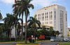
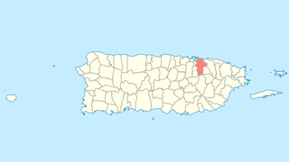
Guaynabo is a city, suburb of San Juan and municipality in the northern part of Puerto Rico, located in the northern coast of the island, north of Aguas Buenas, south of Cataño, east of Bayamón, and west of San Juan. Guaynabo is spread over 9 barrios and Guaynabo Pueblo. Guaynabo is considered, along with its neighbors – San Juan and the municipalities of Bayamón, Carolina, Cataño, Trujillo Alto, and Toa Baja – to be part of the San Juan metropolitan area. It is also part of the larger San Juan-Caguas-Guaynabo Metropolitan Statistical Area,.

<span class="mw-page-title-main">Toa Baja, Puerto Rico</span> Town and municipality in Puerto Rico

Toa Baja is a town and municipality of Puerto Rico located in the northern coast, north of Toa Alta and Bayamón; east of Dorado; and west of Cataño. Toa Baja is spread over five barrios, including Toa Baja Pueblo. Toa Baja is part of the San Juan-Caguas-Guaynabo Metropolitan Statistical Area. Toa Baja is located fifteen minutes by car from San Juan and two hours from Ponce.

<span class="mw-page-title-main">Old San Juan</span> Historic district of San Juan, Puerto Rico

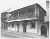
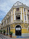
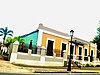
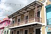
Old San Juan is a historic district located at the "northwest triangle" of the islet of San Juan in San Juan. Its area roughly correlates to the Ballajá, Catedral, Marina, Mercado, San Cristóbal, and San Francisco sub-barrios (sub-districts) of barrio San Juan Antiguo in the municipality of San Juan, Puerto Rico. Old San Juan is the oldest settlement within Puerto Rico and the historic colonial district of the city of San Juan. This historic district is a National Historic Landmark District and is listed on the United States National Register of Historic Places as the Old San Juan Historic District. Several historical buildings and structures, particularly La Fortaleza, the city walls, and El Morro and San Cristóbal castles, have been inscribed in the UNESCO World Heritage Site list since 1983. Historically the mixed use commercial and residential real estate in the main streets like Cristo Street, Fortaleza Street (north) from Tanca Street to the Governor’s Mansion is the most valuable in the area and it has kept its value and increased steadily through several years despite the past economic turmoils.

This is a list of properties and historic districts that are listed on the National Register of Historic Places (NRHP) in Puerto Rico. There are 368 NRHP listings in Puerto Rico, with one or more NRHP listings in each of Puerto Rico's 78 municipalities.

<span class="mw-page-title-main">Catholic Church in Puerto Rico</span> Part of the worldwide Catholic Church in communion with the Pope in Rome

The Catholic Church in Puerto Rico is part of the worldwide Catholic Church in communion with the pope in Rome. The 78 municipalities in Puerto Rico have a Catholic church which is located in the downtown area, normally across from the central plaza.

<span class="mw-page-title-main">Caparra Archaeological Site</span> Archaeological site in Guaynabo municipality, Puerto Rico

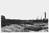
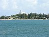
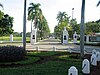
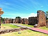
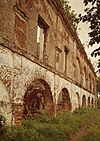
Caparra is an archaeological site in the municipality of Guaynabo, Puerto Rico. It was declared a U.S. National Historic Landmark in 1994. The site contains the remains of the first Spanish capital of the island, settled in 1508 and abandoned in 1521. It represents the oldest known European settlement on United States territory.

<span class="mw-page-title-main">National Register of Historic Places listings in southern Puerto Rico</span>

This is a list of properties and districts in the southern municipalities of Puerto Rico that are listed on the National Register of Historic Places. It includes places along the southern coast of the island, and on the south slope of Puerto Rico's Cordillera Central.

<span class="mw-page-title-main">McCabe Memorial Church</span> Historic church in Ponce, Puerto Rico

McCabe Memorial Church, also known as Iglesia Metodista Unida de la Playa de Ponce, is a historic church building in Barrio Playa in Ponce, Puerto Rico. It dates from 1908, and was designed by Antonin Nechodoma. It was listed on the U.S. National Register of Historic Places in 2008. It is one of four places such listed in Barrio Playa, the others being the U.S. Customs House, the Caja de Muertos Light, and the Cardona Island Light.

<span class="mw-page-title-main">Iglesia San Sebastián Mártir</span> Historic church in San Sebastián, Puerto Rico

The Iglesia San Sebastián Mártir in the plaza in San Sebastián, Puerto Rico was completed in 1897 and listed on the U.S. National Register of Historic Places in 1984.

<span class="mw-page-title-main">Playa, Ponce, Puerto Rico</span> Barrio of Puerto Rico

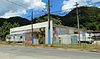
Barrio Playa, also known as Playa de Ponce, Ponce Playa, or La Playa, is one of the thirty-one barrios that comprise the municipality of Ponce, Puerto Rico. Along with Bucaná, Canas, Vayas, and Capitanejo, Playa is one of the municipality's five coastal barrios. Barrio Playa also incorporates several islands, the largest of which is Caja de Muertos. It was founded in 1831.

<span class="mw-page-title-main">Guaynabo barrio-pueblo</span> Historical and administrative center (seat) of Guaynabo, Puerto Rico

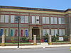
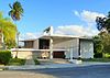
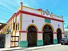
Guaynabo barrio-pueblo is a barrio and the administrative center (seat) of Guaynabo, a municipality of Puerto Rico. Its population in 2010 was 4,008.

<span class="mw-page-title-main">Catedral Santiago Apóstol (Fajardo, Puerto Rico)</span> Historic cathedral in Fajardo, Puerto Rico

The Catedral Santiago Apóstol, or in English, the Cathedral of St. James the Apostle, or Santiago Apóstol of Fajardo is a Catholic cathedral located on the town plaza in Fajardo, Puerto Rico. Along with Concatedral Dulce Nombre de Jesus in Humacao it is the seat of the Diocese of Fajardo-Humacao. It was listed on the National Register of Historic Places as Church Santiago Apóstol of Fajardo in 1984.

<span class="mw-page-title-main">National Register of Historic Places listings in San Juan, Puerto Rico</span>

This portion of National Register of Historic Places listings in Puerto Rico covers the municipality of San Juan.

<span class="mw-page-title-main">Toa Baja barrio-pueblo</span> Historical and administrative center (seat) of Toa Baja, Puerto Rico

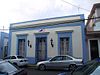
Toa Baja barrio-pueblo is a barrio and the administrative center (seat) of Toa Baja, a municipality of Puerto Rico. Its population in 2010 was 565.

<span class="mw-page-title-main">Iglesia de San Antonio de Padua</span> Historic church in Guayama, Puerto Rico

The Iglesia Parroquial de San Antonio de Padua is a historic, Roman Catholic parish church in Guayama, Puerto Rico. The parish was erected in 1736 and the first church building completed no later than 1775. The original appearance of the building is unknown, but some of the eighteenth century walls may survive in the present structure. The building was rebuilt twice in the nineteenth century and the present appearance dates from 1874. It takes an overall Romanesque form, while the details exhibit the eclecticism that characterized much Puerto Rican architecture in the later 1800s.

<span class="mw-page-title-main">Iglesia Parroquial de San Pedro Mártir de Guaynabo</span> Puerto Rican historic place

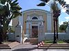
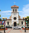
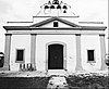
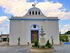
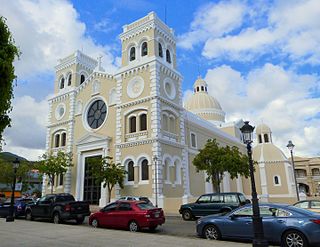
The San Pedro Mártir Parish Church of Guaynabo is a historic parish church of the Roman Catholic Archdiocese of San Juan de Puerto Rico, located in Guaynabo Pueblo in the Puerto Rican municipality of the same name. The church was added to the United States National Register of Historic Places on September 8, 1976.

<span class="mw-page-title-main">Iglesia Parroquial de San Pedro Apostol de Toa Baja</span> United States historic place

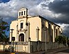
The Saints Peter and Matthew the Apostles Parish Church of Toa Baja, better known as the St. Peter the Apostle Parish Church of Toa Baja, is a historic 16h-century Roman Catholic parish church located in the main town square of Toa Baja Pueblo, the administrative and historic center of the municipality of Toa Baja, Puerto Rico.

<span class="mw-page-title-main">Church, School, Convent and Parish House of San Agustín</span> United States historic place

The Church, School, Convent and Parish House of San Agustín is a National Register of Historic Places (NRHP)-listed historic religious complex located in the Puerta de Tierra historic district of San Juan Antiguo in the city of San Juan, Puerto Rico. The complex consists of the Church of St. Augustine, its adjacent Augustinian convent and the parish house. The church itself was one of the first structures to be built using only concrete in the island and for this reason it is also listed in the Inventory of Historic Churches of Puerto Rico in 1990 in addition to being listed in the NRHP since 1985. The church complex is a contributing property, and, along the Capitol of Puerto Rico, it forms part of the monumental sequence of buildings, memorials and parks along the Ponce de León Avenue that constitute the Puerta de Tierra Historic District.

References

  1. National Park Service, United States Department of the Interior, "National Register of Historic Places: Weekly List Actions", retrieved September 29, 2023.
  2. 1 2 3 4 5 6 7 8 9 10 11 12 13 14 15 16 17 Numbers represent an alphabetical ordering by significant words. Various colorings, defined here, differentiate National Historic Landmarks and historic districts from other NRHP buildings, structures, sites or objects.
  3. 1 2 3 4 5 6 7 8 9 10 11 12 13 14 15 16 17 The eight-digit number below each date is the number assigned to each location in the National Register Information System database, which can be viewed by clicking the number.
  4. 1 2 Llanes Santos, Juan (December 14, 2010), National Register of Historic Places Registration Form: Casa Dr. Agustín Stahl Stamm (PDF), archived from the original (PDF) on November 17, 2015, retrieved November 15, 2015.
  5. Acevedo-Rodrguez, P. (n.d.), "The Botanical Legacy of Agustín Stahl", Flora of Puerto Rico and the Virgin Islands, Smithsonian Institution, National Museum of Natural History, archived from the original on November 6, 2015, retrieved November 15, 2015.
  6. 1 2 Tarr, J. Alexandra (1976), National Register of Historic Places Inventory — Nomination Form: Iglesia Parroquial de San Pedro Martir de Guaynabo (PDF), retrieved April 15, 2017.
  7. 1 2 "Department of the Interior, Heritage Conservation and Recreation Service: National Register of Historic Places; Annual Listing of Historic Properties", 44 FR 7416 (February 6, 1979), at p. 7581.
  8. "Contáctenos", Corporación Mabodamaca, Inc., n.d., archived from the original on January 26, 2016, retrieved January 25, 2016.
  9. 1 2 Davila, Arturo V. (March 27, 1975), National Register of Historic Places Inventory — Nomination Form: Iglesia Parroquial de San Pedro Apostol de Toa Baja (PDF), retrieved January 22, 2016.
  10. 1 2 Federal and state laws and practices restrict general public access to information regarding the specific location of this resource. In some cases, this is to protect archeological sites from vandalism, while in other cases it is restricted at the request of the owner. See: Knoerl, John; Miller, Diane; Shrimpton, Rebecca H. (1990), Guidelines for Restricting Information about Historic and Prehistoric Resources, National Register Bulletin, National Park Service, U.S. Department of the Interior, OCLC   20706997 .