Puerto Rico Highway 167 (PR-167) is one of the main highways in the San Juan–Caguas–Guaynabo metropolitan area of Puerto Rico. Highway 167 starts at Puerto Rico Highway 165 in Levittown and goes until Puerto Rico Highway 156 in Comerío.

The Las Cabañas Bridge is a historic highway bridge in Adjuntas municipality, Puerto Rico. Built in 1919 to provide access to a key coffee-producing region, it was financed by nearby plantations through public subscription. Designer Rafael Nones and builder Félix Benítez Rexach, two of the most prominent figures in Puerto Rican bridge construction in the early 20th century, used a unique combination of steel and concrete technologies to produce a girder design unlike any other on the island and possibly beyond.

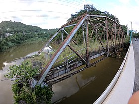
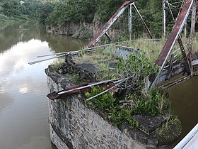
The Villarán Bridge, also known as the Canóvanas Bridge, is a historic bridge over the Canóvanas River in Canóvanas, Puerto Rico. Built in 1892 on the highway between Río Piedras and Río Grande, its iron superstructure was imported from Europe and set on masonry abutments. It is the best-preserved example of an Eiffel pony truss bridge in Puerto Rico or the United States. By 1994, the bridge had been replaced by an adjacent span for vehicular use, but it remained open for pedestrian use.
Manatí Bridge at Mata de Plátano, also known as Puente Juan José Jiménez and listed as Bridge #321 in Puerto Rico's bridge inventory, was built in 1905 in Hato Viejo, Ciales, Puerto Rico. It was listed on the National Register of Historic Places in 1995 and on the Puerto Rico Register of Historic Sites and Zones in 2001.

Bridge No. 122, spanning the Santiago River near Naguabo, Puerto Rico, is significant as "one of the earliest and most elegant examples of concrete beam bridges in Puerto Rico". Built in 1918, it was "futuristic" for its time and has noteworthy architectural detail relative to others. It was designed by Rafael Nones and built by Felix Benitez-Rexach, both engineers, both regarded as masters in their work. Its construction was financed by Puerto Rico's second public bond issue for public works, in 1916, which raised $2 million.

The Arenas Bridge is a truss bridge built in 1894 between the municipalities of Cayey and Cidra in Puerto Rico. Also known as Puente Rio La Plata, it was the longest bridge constructed in Puerto Rico during the Spanish colonial period. It crosses the Rio de la Plata, the longest river in Puerto Rico. According to the U.S. National Park Service, "[t]his is the most important metal bridge in Puerto Rico from the period." The bridge is still standing.

This portion of National Register of Historic Places listings in Puerto Rico is along the central mountain region, from Las Marías and Maricao in the central-west to Juncos in the central-east, including the slopes of the Cordillera.

The Groton Bridge Co. was an American construction company.

The Hondo River Bridge was a historic bridge over the Hondo River in Comerío municipality, Puerto Rico. As of 1995, it was the oldest bridge truss in Puerto Rico, employing a double Warren pony truss design and unique open web transverse joists. It was originally installed in 1881 as one of three spans of the Reyes Católicos Bridge over the Plata River on the San Juan–Mayagüez road, using metal parts fabricated in Belgium. After a hurricane destroyed one of the other spans of the Reyes Católicos Bridge in 1899, this surviving span was moved and re-installed on new abutments under the supervision of engineer Rafael Nones in 1908, as part of the Comerío–Barranquitas road. It was finally removed and replaced in 2001.

The Puente Río Portugués is a historic bridge over the former course of the Río Portugués in barrio Playa in the municipality of Ponce, Puerto Rico. The bridge was added to the U.S. National Register of Historic Places in 2015. The bridge is prominent as "the oldest longitudinal steel beams / reinforced concrete bridge built within the historic Carretera Central". It is located on Avenida Hostos, just south of its intersection with Ponce By Pass.

The Puente de Trujillo Alto is a Pennsylvania through truss bridge built during 1939–1941 in Puerto Rico in the Trujillo Alto municipality of Puerto Rico. At was the longest single-span bridge in Puerto Rico.

The General Norzagaray Bridge is a brick and masonry barrel vault bridge built in 1855 in San Juan, Puerto Rico. Also known as Puente de los Frailes, it brings what is now Puerto Rico Highway 873 across Frailes Creek, a tributary to the Guaynabo River. It has eight 9.8-metre (32 ft) barrel vault spans. Its total length is 120.7 metres (396 ft) and its roadway width is 7.00 metres (22.97 ft). It was listed on the National Register of Historic Places (NRHP) in 1995, and on the Puerto Rico Register of Historic Sites and Zones in 2000.

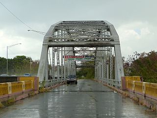
The Cayey Bridge, also known as Puente de Cayey, is an iron lateral lattice girder bridge in Puerto Rico that was built in 1891. It brings Puerto Rico Highway 15 over the Guamaní River. Despite its name, its actually closer to the city of Guayama and not Cayey.
The Puente de Añasco, also called Puente Salcedo, is a bridge spanning between Añasco, Puerto Rico and Mayagüez, Puerto Rico. It was listed on the National Register of Historic Places in 2011. It is located at Kilometer 146.1 of Highway 2.

The Silva Bridge is a Pratt pony truss bridge in Puerto Rico which was built in 1897. It was listed on the National Register of Historic Places in 1995 and on the Puerto Rico Register of Historic Sites and Zones in 2000.

The La Liendre Bridge, spanning Beatriz Creek, a tributary to the Río de la Plata, between Cayey, Puerto Rico and Cidra, Puerto Rico. It was built in 1877 and was listed on the National Register of Historic Places in 1995, and on the Puerto Rico Register of Historic Sites and Zones in 2000.
The Río Matón Bridge, in Matón Abajo, a barrio of Cayey, Puerto Rico, was built in 1886. It was listed on the National Register of Historic Places in 1995 and on the Puerto Rico Register of Historic Sites and Zones in 2000.

Cambalache Bridge or Puente Francés is a bridge built in 1893 which spans the Río Grande de Arecibo from Cambalache barrio to Tanamá barrio in Arecibo. It is located 100 meters west of Puerto Rico Highway 2, at kilometer 72.

The Río Piedras Bridge or Piedras River Bridge, also designated as Bridge #3, is a historic 19th-century barrel vault bridge located in the former town of Río Piedras, today part of the city of San Juan, Puerto Rico, that spans across the Piedras River. The bridge was built in 1853 as part of the development of the Carretera Central that linked San Juan to Ponce, making it the oldest still-existing bridge of said route. Today the bridge is still stable and usable, and it can be found near the entrance of the University of Puerto Rico Botanical Garden. It was added to the National Register of Historic Places in 1995 and on the Puerto Rico Register of Historic Sites and Zones in 2000, and it is considered to be the best-preserved example of a Spanish masonry arch bridge anywhere in Puerto Rico and the United States.
The Prieto River Bridge, also known as Bridge #261 and better known as the "Del Treinta" Bridge, is a historic bridge located in the Indiera Alta barrio of the municipality of Maricao, Puerto Rico. It was built in 1924 as part of a highway construction boom that occurred in the island during the 1920s. The bridge spans across the Prieto River in the Luis Muñoz Marín Scenic Route and was added to the National Register of Historic Places in 1995 and to the Puerto Rico Register of Historic Sites and Zones in 2001.