Vega Alta barrio-pueblo

Last updated
Vega Alta barrio-pueblo
Pueblo de Vega Alta
Municipality Seat [1]
Central plaza and Catholic church in Vega Alta, Puerto Rico.jpg
Vega Alta central plaza, municipal flag of Vega Alta and Catholic church
Vega Alta barrio-pueblo, Puerto Rico locator map.png
Location of Vega Alta barrio-pueblo within the municipality of Vega Alta shown in red
Caribbean location map.svg
Red pog.svg
Vega Alta barrio-pueblo
Location of Puerto Rico
Coordinates: 18°24′41″N66°19′44″W / 18.411456°N 66.328953°W / 18.411456; -66.328953 [2]
Commonwealth Flag of Puerto Rico.svg  Puerto Rico
Municipality Flag of Vega Alta.svg Vega Alta
Area
[2]
  Total0.1 sq mi (0.3 km2)
  Land0.1 sq mi (0.3 km2)
  Water0 sq mi (0 km2)
Elevation
[3]
108 ft (33 m)
Population
 (2010)
  Total1,169
  Density11,690/sq mi (4,510/km2)
 Source: 2010 Census
Time zone UTC−4 (AST)

Vega Alta barrio-pueblo is a barrio and the administrative center (seat) of Vega Alta, a municipality of Puerto Rico. Its population in 2010 was 1,169. [1] [4] [5] [6]

Contents

As was customary in Spain, in Puerto Rico, the municipality has a barrio called pueblo which contains a central plaza, the municipal buildings (city hall), and a Catholic church. Fiestas patronales (patron saint festivals) are held in the central plaza every year. [7] [8]

The central plaza and its church

The central plaza, or square, is a place for official and unofficial recreational events and a place where people can gather and socialize from dusk to dawn. The Laws of the Indies, Spanish law, which regulated life in Puerto Rico in the early 19th century, stated the plaza's purpose was for "the parties" (celebrations, festivities) (Spanish : a propósito para las fiestas), and that the square should be proportionally large enough for the number of neighbors (Spanish : grandeza proporcionada al número de vecinos). These Spanish regulations also stated that the streets nearby should be comfortable portals for passersby, protecting them from the elements: sun and rain. [7]

Located across the central plaza in Vega Alta barrio-pueblo is the Parroquia Inmaculada Concepción, a Roman Catholic church. [9] [10]

History

Vega Alta barrio-pueblo was in Spain's gazetteers [11] until Puerto Rico was ceded by Spain in the aftermath of the Spanish–American War under the terms of the Treaty of Paris of 1898 and became an unincorporated territory of the United States. In 1899, the United States Department of War conducted a census of Puerto Rico finding that the population of Pueblo was 1,081. [12]

Historical population
CensusPop.Note
1900 1,081
1910 1,65753.3%
1920 2,14229.3%
1930 2,88434.6%
1940 3,23812.3%
1950 3,4927.8%
1960 3,182−8.9%
1980 1,583
1990 1,460−7.8%
2000 1,242−14.9%
2010 1,169−5.9%
U.S. Decennial Census
1899 (shown as 1900) [13] 1910-1930 [14]
1930-1950 [15] 1960 [16] 1980-2000 [17] 2010 [18]

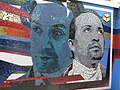
Lin-Manuel Miranda tourism

The Puerto Rican, award-winning, musician and playwright Lin-Manuel Miranda who created the Broadway hit, "Hamilton", is from a family with roots in Vega Alta. In 2017, his father opened the Placita Güisín, a cafe and restaurant in Vega Alta barrio-pueblo. In 2019 Lin-Manuel moved his memorabilia to a new gallery, the Lin-Manuel Miranda Gallery, a few steps from Placita Güisín and opened a store there called TeeRico. The location has become a tourist attraction. [19] [20] [21]

See also

Related Research Articles

<span class="mw-page-title-main">Vega Alta, Puerto Rico</span> Town and municipality in Puerto Rico

Vega Alta is a town and municipality of Puerto Rico. Vega Alta is on the northern coast of the island, north of Morovis and Corozal; east of Vega Baja; and west of Dorado with an area of 28 square miles (73 km2). Vega Alta is subdivided into seven barrios and Vega Alta barrio-pueblo. It is part of the San Juan-Caguas-Guaynabo Metropolitan Statistical Area.

<span class="mw-page-title-main">Bayamón barrio-pueblo</span> Historical and administrative center (seat) of Bayamón, Puerto Rico

Bayamón barrio-pueblo is a barrio and the administrative center (seat) of Bayamón, a municipality of Puerto Rico. Its population in 2010 was 4,746.

<span class="mw-page-title-main">Dorado barrio-pueblo</span> Historical and administrative center (seat) of Dorado, Puerto Rico

Dorado barrio-pueblo is a barrio and the administrative center (seat) of Dorado, a municipality of Puerto Rico. Its population in 2010 was 780. It is one of the six barrios in the municipality of Dorado, Puerto Rico, along with Espinosa, Higuillar, Maguayo, Mameyal and Río Lajas.

<span class="mw-page-title-main">Barceloneta barrio-pueblo</span> Historical and administrative center (seat) of Barceloneta, Puerto Rico

Barceloneta barrio-pueblo is a barrio and the administrative center (seat) of Barceloneta, a municipality of Puerto Rico. Its population in 2010 was 435.

<span class="mw-page-title-main">Yauco barrio-pueblo</span> Historical and administrative center (seat) of Yauco, Puerto Rico

Yauco barrio-pueblo is a barrio and the administrative center (seat) of Yauco, a municipality of Puerto Rico. Its population in 2010 was 3,091.

<span class="mw-page-title-main">Camuy barrio-pueblo</span> Historical and administrative center (seat) of Camuy, Puerto Rico

Camuy barrio-pueblo is a barrio and the administrative center (seat) of Camuy, a municipality of Puerto Rico. Its population in 2010 was 3,354.

<span class="mw-page-title-main">Toa Alta barrio-pueblo</span> Historical and administrative center (seat) of Toa Alta, Puerto Rico

Toa Alta barrio-pueblo is a barrio and the administrative center (seat) of Toa Alta, a municipality of Puerto Rico. Its population in 2010 was 397.

<span class="mw-page-title-main">Jayuya barrio-pueblo</span> Historical and administrative center (seat) of Jayuya, Puerto Rico

Jayuya barrio-pueblo is a barrio and the administrative center (seat) of Jayuya, a municipality of Puerto Rico. Its population in 2010 was 1,222.

<span class="mw-page-title-main">Vega Baja barrio-pueblo</span> Historical and administrative center (seat) of Vega Baja, Puerto Rico

Vega Baja barrio-pueblo is a barrio and downtown area that serves as the administrative center (seat) of Vega Baja, a municipality of Puerto Rico. Its population in 2010 was 816.

<span class="mw-page-title-main">Rincón barrio-pueblo</span> Historical and administrative center (seat) of Rincón, Puerto Rico

Rincón barrio-pueblo is a barrio-pueblo, the administrative center (seat) of Rincón, a municipality of Puerto Rico. Its population in 2010 was 933.

<span class="mw-page-title-main">Maricao barrio-pueblo</span> Historical and administrative center (seat) of Maricao, Puerto Rico

Maricao barrio-pueblo is a barrio and the administrative center (seat) of Maricao, a municipality of Puerto Rico. Its population in 2010 was 716.

<span class="mw-page-title-main">Moca barrio-pueblo</span> Historical and administrative center (seat) of Moca, Puerto Rico

Moca barrio-pueblo is a barrio and the administrative center (seat) of Moca, a municipality of Puerto Rico. Its population in 2010 was 1,735.

<span class="mw-page-title-main">Salinas barrio-pueblo</span> Historical and administrative center (seat) of Salinas, Puerto Rico

Salinas barrio-pueblo is a barrio and the administrative center (seat) of Salinas, a municipality of Puerto Rico. Its population in 2010 was 2,453.

<span class="mw-page-title-main">Santa Isabel barrio-pueblo</span> Historical and administrative center (seat) of Santa Isabel, Puerto Rico

Santa Isabel barrio-pueblo is a barrio and the administrative center (seat) of Santa Isabel, a municipality of Puerto Rico. Its population in 2010 was 5,133.

<span class="mw-page-title-main">Cayey barrio-pueblo</span> Historical and administrative center (seat) of Cayey, Puerto Rico

Cayey barrio-pueblo is a barrio and the administrative center (seat) of Cayey, a municipality of Puerto Rico. Its population in 2010 was 15,298.

<span class="mw-page-title-main">Cerro Gordo, Aguada, Puerto Rico</span> Barrio of Puerto Rico

Cerro Gordo is a barrio in the municipality of Aguada, Puerto Rico. Its population in 2010 was 3,018.

<span class="mw-page-title-main">Carolina barrio-pueblo</span> Historical and administrative center (seat) of Carolina, Puerto Rico

Carolina barrio-pueblo is a barrio and the administrative center (seat) of Carolina, a municipality of Puerto Rico. Its population in 2010 was 1,201.

<span class="mw-page-title-main">Lajas barrio-pueblo</span> Historical and administrative center (seat) of Lajas, Puerto Rico

Lajas barrio-pueblo is a barrio and the administrative center (seat) of Lajas, a municipality of Puerto Rico. Its population in 2010 was 564.

<span class="mw-page-title-main">Trujillo Alto barrio-pueblo</span> Historical and administrative center (seat) of Trujillo Alto, Puerto Rico

Trujillo Alto barrio-pueblo is a barrio and the administrative center (seat) of Trujillo Alto, a municipality of Puerto Rico. Its population in 2010 was 673.

<span class="mw-page-title-main">San Germán barrio-pueblo</span> Historical and administrative center (seat) of San Germán, Puerto Rico

San Germán barrio-pueblo is a barrio and the administrative center (seat) of San Germán, a municipality of Puerto Rico. Its population in 2010 was 2,660.

References

  1. 1 2 Puerto Rico: 2010 Population and Housing Unit Counts.pdf (PDF). U.S. Dept. of Commerce, Economics and Statistics Administration, U.S. Census Bureau. 2010.
  2. 1 2 "US Gazetteer 2019". US Census. US Government.
  3. U.S. Geological Survey Geographic Names Information System: Vega Alta barrio-pueblo
  4. Picó, Rafael; Buitrago de Santiago, Zayda; Berrios, Hector H. Nueva geografía de Puerto Rico: física, económica, y social, por Rafael Picó. Con la colaboración de Zayda Buitrago de Santiago y Héctor H. Berrios. San Juan Editorial Universitaria, Universidad de Puerto Rico,1969.
  5. Gwillim Law (20 May 2015). Administrative Subdivisions of Countries: A Comprehensive World Reference, 1900 through 1998. McFarland. p. 300. ISBN   978-1-4766-0447-3 . Retrieved 25 December 2018.
  6. "US Census Barrio-Pueblo definition". factfinder.com. US Census. Archived from the original on 13 May 2017. Retrieved 5 January 2019.
  7. 1 2 Santullano, Luis A. (10 March 2019). Mirada al Caribe. Vol. 54. Colegio de Mexico. pp. 75–78. doi:10.2307/j.ctvbcd2vs.12. JSTOR   j.ctvbcd2vs.12.
  8. Pariser, Harry S. (2003). Explore Puerto Rico, Fifth Edition . San Francisco: Manatee Press. pp.  52–55. Retrieved 10 February 2019.
  9. Marisa Gomez and Ester Cardona (July 1984). "National Register of Historic Places Inventory/Nomination: Thematic Nomination: Historic Churches of Puerto Rico". National Park Service . Retrieved June 5, 2023.
  10. Mari Mut, José A. (2013-08-28). Los Pueblos de Puerto Rico y Las Iglesias de Sus Plazas [The Pueblos of Puerto Rico, and the Churches of its Plazas] (PDF) (in Spanish). Archived (PDF) from the original on 2020-12-14. Retrieved 2021-09-16.
  11. "Anuario del comercio, de la industria, de la magistratura y de la administración. 1881". Biblioteca Nacional de España (in Spanish). p. 1614. Retrieved 4 April 2023.
  12. Joseph Prentiss Sanger; Henry Gannett; Walter Francis Willcox (1900). Informe sobre el censo de Puerto Rico, 1899, United States. War Dept. Porto Rico Census Office (in Spanish). Imprenta del gobierno. p.  162.
  13. "Report of the Census of Porto Rico 1899". War Department Office Director Census of Porto Rico. Archived from the original on July 16, 2017. Retrieved September 21, 2017.
  14. "Table 3-Population of Municipalities: 1930 1920 and 1910" (PDF). United States Census Bureau. Archived (PDF) from the original on August 17, 2017. Retrieved September 21, 2017.
  15. "Table 4-Area and Population of Municipalities Urban and Rural: 1930 to 1950" (PDF). United States Census Bureau. Archived (PDF) from the original on August 30, 2015. Retrieved September 21, 2014.
  16. Census of Population, 1960: Number of Inhabitants, General Population Characteristics, General Social and Economic Characteristics, and Detailed Characteristics. Characteristics of the population. U.S. Bureau of the Census. 1963. pp. 97–101. Retrieved June 10, 2023.
  17. "Table 2 Population and Housing Units: 1960 to 2000" (PDF). United States Census Bureau. Archived (PDF) from the original on July 24, 2017. Retrieved September 21, 2017.
  18. Puerto Rico: 2010 Population and Housing Unit Counts.pdf (PDF). U.S. Dept. of Commerce Economics and Statistics Administration U.S. Census Bureau. 2010. Archived (PDF) from the original on 2017-02-20. Retrieved 2019-08-02.
  19. Paulson, Michael (December 26, 2018). "Lin-Manuel Miranda's Passion for Puerto Rico". NYT.
  20. Ayala Polley, Leonor (May 1, 2016). "In Lin-Manuel Miranda's Puerto Rican Town, Crisis Worries Family Members". NBC.
  21. "Lin-Manuel Miranda inaugura galería en Vega Alta". El Nuevo Dia. 30 April 2019.