
Guayanilla is a town and municipality of Puerto Rico located on the southern coast of the island, bordering the Caribbean Sea, south of Adjuntas, east of Yauco; and west of Peñuelas and about 12 miles (19 km) west of Ponce. Guayanilla is spread over 16 barrios and Guayanilla Pueblo. It is part of the Yauco Metropolitan Statistical Area.

Utuado is a town and municipality of Puerto Rico located in the central mountainous region of the island known as the Cordillera Central. It is located north of Adjuntas and Ponce; south of Hatillo and Arecibo; east of Lares; and west of Ciales and Jayuya. It is the third-largest municipality in land area in Puerto Rico. According to the 2020 US Census, the municipality has a population of 28,287 spread over 24 barrios and Utuado pueblo.

The Cordillera Central is the only mountain range in the main island of Puerto Rico, consisting of three subranges: the western-central Cordillera Central, the southeastern Sierra de Cayey, and the northeastern Sierra de Luquillo. Bordered by the Northern Karst Belt to the northwest and costal plains to the north and south, the numerous ridges and foothills of the three subranges combined extend throughout the island. Concentrated in the western to central region of the island, the eponymous main subrange of Cordillera Central originates in the municipality of Mayagüez and merges with the Sierra de Cayey subrange on the town boundary between the municipalities of Barranquitas and Aibonito. At 1,338 meters on the town line between Ponce and Jayuya, Cerro de Punta is the summit of the Cordillera Central and the highest point in Puerto Rico.

The Catholic Church in Puerto Rico is part of the worldwide Catholic Church in communion with the pope in Rome. The 78 municipalities in Puerto Rico have a Catholic church which is located in the downtown area, normally across from the central plaza.
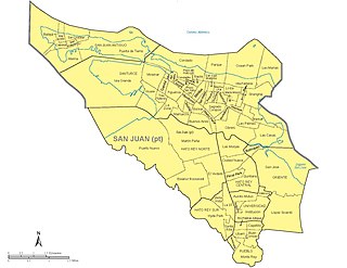
The municipality of San Juan is divided into 18 barrios, 16 of which fall within the former municipality of Río Piedras. Eight of the barrios are further divided into subbarrios, and they include the two barrios that originally composed the municipality of San Juan :
Béisbol Doble A, governed by the Federación de Béisbol Aficionado de Puerto Rico, is a Puerto Rican amateur baseball spring and summer baseball league, founded in 1940 and based in San Juan. The season normally starts in mid to late February and ends with the Carnaval de Campeones final in September. They play a weekend schedule, and their all-star game is held soon after the regular season and before the playoffs. The actual defending champions 2024, Titanes de Florida, obtained their second league championship in their history, something they had not achieved since 1982, 42 years ago.

Puerto Rico Highway 2 (PR-2) is a road in Puerto Rico that connects the cities of San Juan and Ponce. At 156 miles (230 km) long, it is Puerto Rico's longest singled-signed highway.
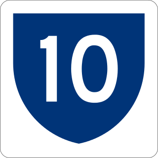
Puerto Rico Highway 10 (PR-10) is a major highway in Puerto Rico. The primary state road connects the city of Ponce in the south coast to Arecibo in the north; it is also the shortest route between the two cities.

The San Juan–Bayamón–Caguas metropolitan area, most commonly known as the San Juan metropolitan area, is the largest and most populous metropolitan statistical area (MSA) in Puerto Rico, concentrated in the capital municipality of San Juan and surrounding municipalities, including Bayamón, Caguas, and Carolina, on the northeastern coastal plain of the main island. One of 6 metropolitan statistical areas in Puerto Rico, it lies within the San Juan–Bayamón combined statistical area (CSA), which is one of 3 primary statistical areas in the main island as defined by the United States Census Bureau. As of 2023, census estimates place the population of the San Juan–Bayamón–Caguas metropolitan area at 2,035,733.
The Ruta Panorámica, officially the Ruta Panorámica Luis Muñoz Marín, is a 167-mile (269 km) network of some 40 secondary roads which traverse the island of Puerto Rico from west to east along its Cordillera Central. Most of the route consists of three roads, PR-105, PR-143, and PR-182. The route starts in Mayagüez and ends in Maunabo. The first major segment of the route runs from Mayagüez to Maricao as Route 105, then from Adjuntas to Aibonito as Route 143, and then follows Route 182 toward Maunabo.
The Puerto Rico Firefighters Corps (PRFC); is the statewide fire department that provides fire protection, rescue, and protection from other hazards in the U.S. Estado Asociado Libre of Puerto Rico. It was established in 1942 under the Puerto Rico Fire Services. In addition, it offers fire protection services to all the airports under the authority of the Puerto Rico Ports Authority, Rafael Hernández Airport, and Mercedita Airport and they serve as crash rescue divisions. A separate agency, the Puerto Rico Medical Emergency Corps, provides emergency medical services to all Puerto Rico.
Río Cañas is a river in Ponce, Puerto Rico. It is a tributary of the Río Matilde.
Miss Universe Puerto Rico 2013 was the 58th Annual Miss Universe Puerto Rico pageant, held at the Centro de Bellas Artes de Santurce in San Juan, Puerto Rico, on August 29, 2012.

In 1953, the Puerto Rico Department of Transportation and Public Works implemented a major renumbering of its insular highways. Before 1953, highway routes were numbered in the 1 to just over 100 range and were distributed randomly throughout the island, resulting in several routes with long road lengths. The numbering system adopted in 1953, which is in use today, increased the range of route numbers from the just-over-100 to 999, resulting in a decrease in the length of many routes. This new numbering system follows a grid pattern for highways numbered between 100 and 999, with the lower numbered roads found to the west and systematically increasing towards 999 as the traveler moves easterly. Although PR-1, PR-2 and PR-3 routes had notable changes in some of their segments, these three are the only highways that kept their route numbers intact due to their interregional prominence.
Pueblo is a term primarily used in Puerto Rico to refer to the municipal district (barrio) that serves as the administrative, historic and cultural center of a municipality. The concept of pueblo is often used locally as analogous to the concept of downtown in U.S. cities. Pueblos are officially called barrio-pueblo by the United States Census since 1990.
