San Juan is the capital city and most populous municipality in the Commonwealth of Puerto Rico, an unincorporated territory of the United States. As of the 2020 census, it is the 57th-largest city under the jurisdiction of the United States, with a population of 342,259. San Juan was founded by Spanish colonists in 1521, who called it Ciudad de Puerto Rico.
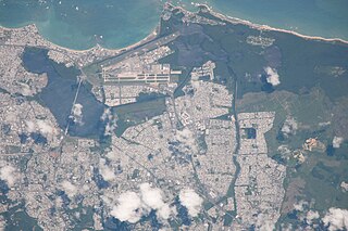
Isla Verde is a beach-front, urbanized, residential, and resort district in the barrio of Cangrejo Arriba in the municipality of Carolina where the main airport of Puerto Rico, the Luis Muñoz Marín International Airport (SJU), is located. It is Immediately east of the barrio of Santurce in the capital municipality of San Juan, Los Corozos and San José Lagoon, and Teodoro Moscoso Bridge, which connects the coastal area to Hato Rey, the commercial and financial center in the metropolitan area of Puerto Rico, and west of the Laguna La Torrecilla, and the state forest and beaches of the Piñones district in the barrio of Torrecilla Baja in the municipality of Loíza. Isla Verde is home to various upscale hotels and apartments.

Miramar is one of the forty subbarrios of Santurce, San Juan, Puerto Rico. The neighborhood has many historic Spanish Revival-style homes with patios and gardens, and it was listed on the Puerto Rico Register of Historic Sites and Zones in 2007 for its historical and architectural value.

Puerta de Tierra is a subbarrio (subdistrict) occupying the eastern portion of the Islet of San Juan and the barrio of San Juan Antiguo in the municipality of San Juan, Puerto Rico. The name Puerta de Tierra derives from the former eastern gated entrance to the walled city of San Juan where Plaza Colón is today. With a population of 2,924 as of 2010, this is the most populated area of San Juan Antiguo. On October 15, 2019, it was added to the National Register of Historic Places.
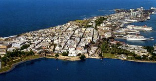
San Juan Islet is a 3-square-mile (7.8 km2) islet or small island on San Juan Bay in the Atlantic coast of northern Puerto Rico. Home to Old San Juan, it is the site of the oldest permanent European settlement in Puerto Rico (1521), and the second oldest European settlement in the West Indies after Santo Domingo (1496). Due to its strategic location in the Caribbean during the Spanish colonization of the Americas, it is home to a city wall and a number of militaristic buildings such as El Morro Castle. Today, it is also home to many of Puerto Rico's government buildings such as the territory's capitol building.
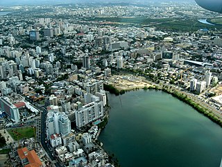
Santurce is the largest and most populated barrio of the municipality of San Juan, the capital city of Puerto Rico. With a population of 69,469 in 2020, Santurce is also one of the most densely populated areas of the main island of Puerto Rico with a population larger than most municipalities of the territory.

Ocean Park is an upscale beachfront community within the barrio of Santurce, in the municipality of San Juan, Puerto Rico. It is one of the forty subbarrios of Santurce.
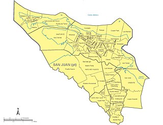
The municipality of San Juan is divided into 18 barrios, 16 of which fall within the former municipality of Río Piedras. Eight of the barrios are further divided into subbarrios, and they include the two barrios that originally composed the municipality of San Juan :
Condado Lagoon is located in San Juan, Puerto Rico. It is an effluent body of water that flows freely between the Condado and Miramar neighborhoods of Santurce, a barrio of San Juan.

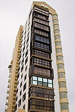
The Condado Vanderbilt Hotel is a historic luxury hotel built in 1919 and located on Ashford Avenue in the district of Condado in San Juan, capital city of the U.S. territory of Puerto Rico. It was listed on the National Register of Historic Places in 2008. The hotel was designed by the architectural firm Warren and Wetmore, who also designed New York's Grand Central Terminal. It was built by the Vanderbilt family and it marked the beginning of high end tourism in Puerto Rico.

Hato Rey Central is one of the 18 barrios of the municipality of San Juan, Puerto Rico. It is one of three barrios formerly known as Hato Rey. With a population density of 16,155.3 per square mile. It has a land area of 1.03 sq mi and a 2010 Census population of 16,640.

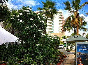
La Concha Renaissance San Juan Resort, also known as La Concha Resort, is a historic luxury resort located at the Condado oceanfront within the district of Santurce in San Juan, Puerto Rico.

Isla Grande is one of 40 subbarrios of Barrio Santurce, in San Juan, Puerto Rico.

Parque is one of the forty subbarrios of Santurce, San Juan, Puerto Rico. It is located between Condado and Ocean Park.

The Dos Hermanos Bridge is a bridge in San Juan, Puerto Rico. It connects the sector of Condado with the entrance to Old San Juan, crossing over the Condado Lagoon. It was designed and built by brothers Hernan and Sosthenes Behn, and opened in June 1910.

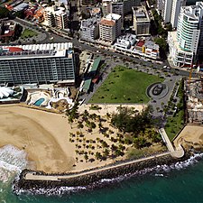
La Ventana al Mar on Avenida Ashford in the district of Condado, of San Juan, Puerto Rico is a large public space built in 2004 fronting the Atlantic Ocean. The park is flanked by two of Condado's landmark hotels: to the west by the Condado Vanderbilt Hotel (1919), designed by Warren and Whitmore, and to the east by the La Concha Hotel (1957), designed by Toro Ferrer. The 1.8 hectare public space was developed by the Commonwealth of Puerto Rico's Tourism Company, and has been credited as one of the principal motors steering the district's urban revitalisation.

El Boquerón is a body of water located at the intersection of the Condado Lagoon and the San Antonio Channel in San Juan, Puerto Rico. This body of water separates the Islet of San Juan, where Old San Juan and Puerta de Tierra are located, from El Condado and the Isla Grande peninsula in Santurce. It is separated from the San Antonio Channel by the San Antonio Bridge and from the Condado Lagoon by the Dos Hermanos Bridge. This body of water contains coral reef and habitats important to plant and animal life; it is part of the bigger San Juan Bay National Estuary. These bodies of water are often visited by manatees. The Playita del Condado is located at the eastern end of El Boquerón.

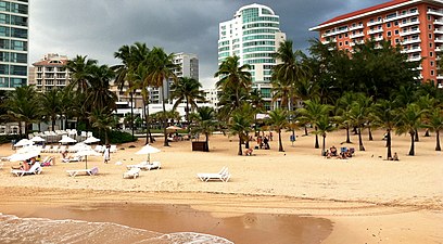
Condado Beach is a large public-access beach located in Condado, a subbarrio of the barrio of Santurce in the capital municipality of San Juan in Puerto Rico.