
San Juan is the capital city and most populous municipality in the Commonwealth of Puerto Rico, an unincorporated territory of the United States. As of the 2020 census, it is the 57th-largest city under the jurisdiction of the United States, with a population of 342,259. San Juan was founded by Spanish colonists in 1521, who called it Ciudad de Puerto Rico.

Arecibo is a city and municipality on the northern coast of Puerto Rico, on the shores of the Atlantic Ocean, located north of Utuado and Ciales; east of Hatillo; and west of Barceloneta and Florida. It is about 50 miles (80 km) west of San Juan, the capital city. Arecibo is the largest municipality in Puerto Rico by area, and it is the core city of the Arecibo Metropolitan Statistical Area and part of the greater San Juan Combined Statistical Area. It is spread over 18 barrios and Arecibo Pueblo. Its population in 2020 was 87,754.

Condado is an oceanfront, tree-lined, pedestrian-oriented upper middle to upper class community in Santurce. It is one of the forty subbarrios of Santurce in San Juan, Puerto Rico.
Hernan Behn (February 19,1880 Saint Thomas, Virgin Islands– October 7, 1933 in Saint-Jean-de-Luz, France co-founded the Puerto Rico Telephone Company which eventually spawned ITT. Behn, along with his brother Sosthenes built the Two Brothers Bridge —Puente Dos Hermanos in Spanish— in San Juan. The bridge links the districts of Condado and Old San Juan.
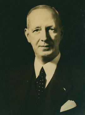
Sosthenes Behn was an American businessman, and the founder of ITT. He held the rank of lieutenant colonel in the U.S. Army.

Añasco, named after one of its settlers, Don Luis de Añasco, is a town and municipality of Puerto Rico located on the west coast of the island bordering the Mona Passage to the west, north of Mayagüez, and Las Marias; south of Rincón, Aguada, and Moca and west of San Sebastián and Las Marias. It is part of the Aguadilla-Isabela-San Sebastián Metropolitan Statistical Area.

Isla Verde is an area of Carolina located east of Santurce next to Luis Muñoz Marín International Airport above the Teodoro Moscoso Bridge. The area lies just outside the eastern border of San Juan, capital of Puerto Rico that links with the college town of Río Piedras and the residential counterpart surroundings of Hato Rey, which includes the neighborhoods of Baldrich and University Gardens revolving around Golden Mile's financial district.

Miramar is one of the forty subbarrios of Santurce, San Juan, Puerto Rico. It has many Spanish-style homes with patios and gardens.

Puerta de Tierra is a subbarrio (subdistrict) occupying the eastern portion of the Islet of San Juan and the barrio of San Juan Antiguo in the municipality of San Juan, Puerto Rico. The name Puerta de Tierra derives from the former eastern gated entrance to the walled city of San Juan where Plaza Colón is today. With a population of 2,924 as of 2010, this is the most populated area of San Juan Antiguo. On October 15, 2019, it was added to the National Register of Historic Places, to be included with the Old San Juan Historic District.
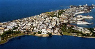
The Isleta de San Juan is a 3-square-mile (7.8 km2) island in the San Juan Bay in the Atlantic coast of northern Puerto Rico. Home of Old San Juan, it is the site of the oldest permanent European settlement in Puerto Rico (1521), and the second oldest European settlement in the West Indies after Santo Domingo (1496). Due its strategic location in the Caribbean during the Spanish colonization of the Americas it is home to a city wall and a number of militaristic buildings such as El Morro Castle. Today it is also home to many of Puerto Rico's government buildings such as the territory's capitol building.

Claro Puerto Rico is one of the largest telecommunications services company in Puerto Rico. It is headquartered in Guaynabo, Puerto Rico, and has operated for almost a century offering voice, data, long distance, broadband, directory publishing and wireless services for the island residents and businesses. It was founded by the Behn brothers, Sosthenes and Hernan. Originally, Puerto Rico Telephone Company eventually spawned ITT Corporation, which was founded by Sosthenes Behn. The company was a public corporation of the government of Puerto Rico for many years until the majority stakes were acquired by GTE in the mid-1990s. It was a subsidiary of Verizon Communications until it was fully acquired by América Móvil in 2007.
Santurce is a barrio or district in the municipality of San Juan. Its population in 2020 was 69,469. It is also the biggest and most populated of all the barrios in the capital city with a bigger population than most municipalities of Puerto Rico and one of the most densely populated areas of the island.
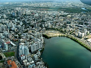
Condado Lagoon is located in San Juan, Puerto Rico. It is an effluent body of water that flows freely between the Condado and Miramar neighborhoods of Santurce, a barrio of San Juan.

The Condado Vanderbilt Hotel is a historic luxury hotel built in 1919 and located on Ashford Avenue in the district of Condado in San Juan, capital city of the U.S. territory of Puerto Rico. It was listed on the National Register of Historic Places in 2008. The hotel was designed by the architectural firm Warren and Wetmore, who also designed New York's Grand Central Terminal. It was built by the Vanderbilt family and it marked the beginning of high end tourism in Puerto Rico.
Phi Delta Gamma (ΦΔΓ) of Puerto Rico is the first Puerto Rican organization of Greek letters, which was founded in the western town of Mayagüez, on April 25, 1942.
The following is a timeline of the history of the municipality of San Juan, Puerto Rico.

San Juan Bay is the bay and main inlet adjacent to Old San Juan in northeastern Puerto Rico. It is about 3.5 miles (5.6 km) in length, the largest body of water in an estuary of about 97 square miles (250 km2) of channels, inlets and eight interconnected lagoons. The San Juan Bay is home to the island's busiest harbor and its history dates back to at least 1508.

La Ventana al Mar on Ashford Avenue in the district of Condado, of San Juan, Puerto Rico is a large public space built in 2004 fronting the Atlantic Ocean. The park is flanked by two of Condado's landmark hotels: to the west by the Condado Vanderbilt Hotel (1919), designed by Warren and Whitmore, and to the east by the La Concha Hotel (1957), designed by Toro Ferrer. The 1.8 hectare public space was developed by the Commonwealth of Puerto Rico's Tourism Company, and has been credited as one of the principal motors steering the district's urban revitalisation.

El Boquerón is a body of water located at the intersection of the Condado Lagoon and the San Antonio Channel in San Juan, Puerto Rico. This body of water separates the Islet of San Juan, where Old San Juan and Puerta de Tierra are located, from El Condado and the Isla Grande peninsula in Santurce. It is separated from the San Antonio Channel by the San Antonio Bridge and from the Condado Lagoon by the Dos Hermanos Bridge. This body of water contains coral reef and habitats important to plant and animal life; it is part of the bigger San Juan Bay National Estuary. These bodies of water are often visited by manatees. The Playita del Condado is located at the eastern end of El Boquerón.

