Espinar, Aguada, Puerto Rico

Last updated
Espinar
Barrio
Puente de Coloso - Aguada Puerto Rico.jpg
Puente de Coloso
Espinar, Aguada, Puerto Rico locator map.png
Location of Espinar within the municipality of Aguada shown in red
Caribbean location map.svg
Red pog.svg
Espinar
Location of Puerto Rico
Coordinates: 18°24′28″N67°09′46″W / 18.407853°N 67.162911°W / 18.407853; -67.162911 [1]
Commonwealth Flag of Puerto Rico.svg  Puerto Rico
Municipality Aguada flag.png Aguada
Area
[1]
  Total1.23 sq mi (3.2 km2)
  Land0.86 sq mi (2.2 km2)
  Water0.37 sq mi (1.0 km2)
Elevation
[2]
0 ft (0 m)
Population
 (2010)
  Total1,281
  Density1,489.5/sq mi (575.1/km2)
 Source: 2010 Census
Time zone UTC−4 (AST)
ZIP Code
00602
Area code(s) 787, 939

Espinar is a barrio in the municipality of Aguada, Puerto Rico. Its population in 2010 was 1,281. [3] [4] [5]

Contents

History

Espinar is located near the Culebrinas River and is named after a Franciscan priest who founded a convent there. In 1529, Espinar and other priests were assassinated by the indigenous Island Caribs. Their deaths resulted in a hermitage being built for honoring their martyrdom. Later on, Franciscan priests erected a new church over the ruins of the first and, to this day, religious services are held there. [6] [7]

Espinar was in Spain's gazetteers [8] until Puerto Rico was ceded by Spain in the aftermath of the Spanish–American War under the terms of the Treaty of Paris of 1898 and became an unincorporated territory of the United States. In 1899, the United States Department of War conducted a census of Puerto Rico finding that the population of Espinar and Carrizal barrios was 1,010. [9]

Puente de Coloso

The Puente de Coloso, a bridge used during the height of sugarcane production in Puerto Rico is located near Espinar.

Historical population
CensusPop.Note
1910 530
1920 5768.7%
1930 510−11.5%
1940 64927.3%
1950 79021.7%
1960 1,24457.5%
1970 1,39111.8%
1980 1,58714.1%
1990 1,378−13.2%
2000 1,56913.9%
2010 1,281−18.4%
U.S. Decennial Census
1900 (N/A) [10] 1910-1930 [11]
1930-1950 [12] 1960 [13] 1980-2000 [14] 2010 [15]

Sectors

Barrios (which are, in contemporary times, roughly comparable to minor civil divisions) [16] in turn are further subdivided into smaller local populated place areas/units called sectores (sectors in English). The types of sectores may vary, from normally sector to urbanización to reparto to barriada to residencial, among others. [17] [18] [19] [20] [21]

The following sectors are in Espinar barrio: [22]

Brisas de Espinar (Solares), Parcelas Pastos Comunales, Sector El Caracol, Sector Hernández Ramírez, Sector Hoyo Frío, Sector La Playa, Sector Marcial, and Sector Río Culebrinas.

See also

Related Research Articles

<span class="mw-page-title-main">Voladoras</span> Barrio of Moca, Puerto Rico

Voladoras is a barrio in the municipality of Moca, Puerto Rico. Its population in 2010 was 4,710.

<span class="mw-page-title-main">Cruz, Moca, Puerto Rico</span> Barrio of Puerto Rico

Cruz is a barrio in the municipality of Moca, Puerto Rico. Its population in 2010 was 1,127.

<span class="mw-page-title-main">Rocha, Moca, Puerto Rico</span> Barrio of Puerto Rico

Rocha is a barrio in the municipality of Moca, Puerto Rico. Its population in 2010 was 4,004.

<span class="mw-page-title-main">Culebrinas</span> Barrio of San Sebastián, Puerto Rico

Culebrinas is a barrio in the municipality of San Sebastián, Puerto Rico. Its population in 2010 was 3,787.

<span class="mw-page-title-main">Magos, San Sebastián, Puerto Rico</span> Barrio of Puerto Rico

Magos is a barrio in the municipality of San Sebastián, Puerto Rico. Its population in 2010 was 232.

<span class="mw-page-title-main">Aguada barrio-pueblo</span> Historical and administrative center (seat) of Aguada, Puerto Rico

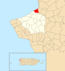
Aguada barrio-pueblo is a small barrio and the administrative center (seat) of Aguada, a municipality of Puerto Rico. Its population in 2010 was 1,324. Aguada barrio-pueblo has two subdivisions: California and Rosario.

<span class="mw-page-title-main">Naranjo, Aguada, Puerto Rico</span> Barrio of Puerto Rico

Naranjo is a barrio in the municipality of Aguada, Puerto Rico. Its population in 2010 was 3,292.

<span class="mw-page-title-main">Mamey, Aguada, Puerto Rico</span> Barrio of Puerto Rico

Mamey is a barrio in the municipality of Aguada, Puerto Rico. Its population in 2010 was 2,400.

<span class="mw-page-title-main">Cerro Gordo, Aguada, Puerto Rico</span> Barrio of Puerto Rico

Cerro Gordo is a barrio in the municipality of Aguada, Puerto Rico. Its population in 2010 was 3,018.

<span class="mw-page-title-main">Río Grande, Aguada, Puerto Rico</span> Barrio of Puerto Rico

Río Grande is a barrio in the municipality of Aguada, Puerto Rico. Its population in 2010 was 1,152.

<span class="mw-page-title-main">Atalaya, Aguada, Puerto Rico</span> Barrio of Puerto Rico

Atalaya is a barrio in the municipality of Aguada, Puerto Rico. Its population in 2010 was 3,108.

<span class="mw-page-title-main">Piedras Blancas, Aguada, Puerto Rico</span> Barrio of Puerto Rico

Piedras Blancas is a barrio in the municipality of Aguada, Puerto Rico. Its population in 2010 was 4,635.

<span class="mw-page-title-main">Jagüey, Aguada, Puerto Rico</span> Barrio of Puerto Rico

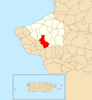
Jagüey is a barrio (county) in the municipality of Aguada, Puerto Rico. Its population in 2010 was 1,995. It is located west of the center of Aguada partly bordering the municipality of Rincón.

<span class="mw-page-title-main">Marías, Aguada, Puerto Rico</span> Barrio of Puerto Rico

Marías is a barrio in the municipality of Aguada, Puerto Rico. Its population in 2010 was 1,997.

<span class="mw-page-title-main">Carrizal, Aguada, Puerto Rico</span> Barrio of Puerto Rico

Carrizal is a barrio in the municipality of Aguada, Puerto Rico. Its population in 2010 was 970.

<span class="mw-page-title-main">Cruces, Aguada, Puerto Rico</span> Barrio of Puerto Rico

Cruces is a barrio in the municipality of Aguada, Puerto Rico. Its population in 2010 was 1,632.

<span class="mw-page-title-main">Guanábano, Aguada, Puerto Rico</span> Barrio of Puerto Rico

Guanábano is a barrio in the municipality of Aguada, Puerto Rico. Its population in 2010 was 749.

<span class="mw-page-title-main">Guaniquilla, Aguada, Puerto Rico</span> Barrio of Puerto Rico

Guaniquilla is a coastal barrio in the municipality of Aguada, Puerto Rico. Its population in 2010 was 2,663.

<span class="mw-page-title-main">Guayabo, Aguada, Puerto Rico</span> Barrio of Puerto Rico

Guayabo is a barrio in the municipality of Aguada, Puerto Rico. Its population in 2010 was 3,273.

<span class="mw-page-title-main">Mal Paso, Aguada, Puerto Rico</span> Barrio of Puerto Rico

Mal Paso is a barrio in the municipality of Aguada, Puerto Rico. Its population in 2010 was 2,483.

References

  1. 1 2 "US Gazetteer 2019". US Census. US Government.
  2. U.S. Geological Survey Geographic Names Information System: Espinar Barrio
  3. Picó, Rafael; Buitrago de Santiago, Zayda; Berrios, Hector H. Nueva geografía de Puerto Rico: física, económica, y social, por Rafael Picó. Con la colaboración de Zayda Buitrago de Santiago y Héctor H. Berrios. San Juan Editorial Universitaria, Universidad de Puerto Rico,1969.
  4. Gwillim Law (20 May 2015). Administrative Subdivisions of Countries: A Comprehensive World Reference, 1900 through 1998. McFarland. p. 300. ISBN   978-1-4766-0447-3 . Retrieved 25 December 2018.
  5. Puerto Rico: 2010 Population and Housing Unit Counts.pdf (PDF). U.S. Dept. of Commerce, Economics and Statistics Administration, U.S. Census Bureau. 2010.
  6. "Barrios de Puerto Rico: Barrio Espinar de Aguada [The History of Puerto Rico through its Barrios: Espinar of Aguada]" (video). www.pbslearningmedia.org (in Spanish). Fundación Puertorriqueña de las Humanidades and Sistemas TV. Retrieved 2 September 2020.
  7. "Parroquia Inmaculada Concepción". capuchinospr.org (in Spanish). Retrieved 3 September 2020.
  8. "Anuario del comercio, de la industria, de la magistratura y de la administración. 1881". Biblioteca Nacional de España (in Spanish). p. 1614. Retrieved 4 April 2023.
  9. Joseph Prentiss Sanger; Henry Gannett; Walter Francis Willcox (1900). Informe sobre el censo de Puerto Rico, 1899, United States. War Dept. Porto Rico Census Office (in Spanish). Imprenta del gobierno. p.  160.
  10. "Report of the Census of Porto Rico 1899". War Department Office Director Census of Porto Rico. Archived from the original on July 16, 2017. Retrieved September 21, 2017.
  11. "Table 3-Population of Municipalities: 1930 1920 and 1910" (PDF). United States Census Bureau. Archived (PDF) from the original on August 17, 2017. Retrieved September 21, 2017.
  12. "Table 4-Area and Population of Municipalities Urban and Rural: 1930 to 1950" (PDF). United States Census Bureau. Archived (PDF) from the original on August 30, 2015. Retrieved September 21, 2014.
  13. Census of Population, 1960: Number of Inhabitants, General Population Characteristics, General Social and Economic Characteristics, and Detailed Characteristics. Characteristics of the population. U.S. Bureau of the Census. 1963. pp. 97–101. Retrieved June 10, 2023.
  14. "Table 2 Population and Housing Units: 1960 to 2000" (PDF). United States Census Bureau. Archived (PDF) from the original on July 24, 2017. Retrieved September 21, 2017.
  15. Puerto Rico: 2010 Population and Housing Unit Counts.pdf (PDF). U.S. Dept. of Commerce Economics and Statistics Administration U.S. Census Bureau. 2010. Archived (PDF) from the original on 2017-02-20. Retrieved 2019-08-02.
  16. "US Census Barrio-Pueblo definition". factfinder.com. US Census. Archived from the original on 13 May 2017. Retrieved 5 January 2019.
  17. Mari Mut, José A. (28 August 2013). "Los pueblos de Puerto Rico y las iglesias de sus plazas" (in Spanish). Retrieved 19 June 2020 via archive.org.
  18. "Agencia: Oficina del Coordinador General para el Financiamiento Socioeconómico y la Autogestión (Proposed 2016 Budget)". Puerto Rico Budgets (in Spanish). Retrieved 28 June 2019.
  19. Rivera Quintero, Marcia (2014), El vuelo de la esperanza : Proyecto de las Comunidades Especiales Puerto Rico, 1997-2004 (Primera edición ed.), San Juan, Puerto Rico Fundación Sila M. Calderón, ISBN   978-0-9820806-1-0
  20. "Leyes del 2001". Lex Juris Puerto Rico (in Spanish). Retrieved 24 June 2019.
  21. "Comunidades Especiales de Puerto Rico" (in Spanish). 8 August 2011. Retrieved 24 June 2019.
  22. "DESGLOSE DE SECTORES Y CENTROS DE VOTACIÓN PRECINTO ELECTORAL - AGUADA 038" (PDF). Comisión Estatal de Elecciones Puerto Rico (in Spanish). 28 October 2019. Archived from the original (PDF) on 16 June 2020. Retrieved 15 June 2020.