Indios, Guayanilla, Puerto Rico

Last updated
Indios
Barrio
View of sea in Indios, Guayanilla, Puerto Rico.jpg
View of the Caribbean Sea from Indios
Indios, Guayanilla, Puerto Rico locator map.png
Location of Indios within the municipality of Guayanilla shown in red
Caribbean location map.svg
Red pog.svg
Indios
Location of Puerto Rico
Coordinates: 18°00′30″N66°48′37″W / 18.008415°N 66.810173°W / 18.008415; -66.810173 [1]
Commonwealth Flag of Puerto Rico.svg  Puerto Rico
Municipality Flag of Guayanilla.svg Guayanilla
Area
[1]
  Total5.31 sq mi (13.8 km2)
  Land4.78 sq mi (12.4 km2)
  Water0.53 sq mi (1.4 km2)
Elevation
[2]
180 ft (50 m)
Population
 (2010)
  Total2,647
  Density553.8/sq mi (213.8/km2)
 Source: 2010 Census
Time zone UTC−4 (AST)

Indios is a rural barrio in the municipality of Guayanilla, Puerto Rico. Its population in 2010 was 2,647. [3] [4]

Contents

Features and demographics

Indios has 4.78 square miles (12.4 km2) of land area and .53 square miles (1.4 km2) of water area. In 2010, its population was 2,647 with a population density of 553.8 inhabitants per square mile (213.8/km2). [5]

Historical population
CensusPop.Note
1910 411
1920 373−9.2%
1930 361−3.2%
1940 59364.3%
1950 1,839210.1%
1960 1,443−21.5%
1970 1,4812.6%
1980 1,90428.6%
1990 2,31821.7%
2000 2,3390.9%
2010 2,64713.2%
U.S. Decennial Census
1900 (N/A) [6] 1910-1930 [7]
1930-1950 [8] 1980-2000 [9] 2010 [10]

History

Indios was in Spain's gazetteers [11] until Puerto Rico was ceded by Spain in the aftermath of the Spanish–American War under the terms of the Treaty of Paris of 1898 and became an unincorporated territory of the United States. In 1899, the United States Department of War conducted a census of Puerto Rico finding that the combined population of Indios barrio and Boca barrio was 782. [12]

2019-2020 earthquakes

A series of earthquakes began occurring near Indios on December 28, 2019 and continued through January 2020, with 11 earthquakes over a 5 magnitude (and a 6.4) and 300 over a 3 magnitude in strength. [13]

See also

Related Research Articles

<span class="mw-page-title-main">Aceitunas</span> Barrio of Moca, Puerto Rico

Aceitunas is a barrio in the municipality of Moca, Puerto Rico with a population of 3,098 in 2010. The land area of this subdivision is 5.36 square miles (13.9 km2).

<span class="mw-page-title-main">Macaná, Guayanilla, Puerto Rico</span> Barrio of Puerto Rico

Macaná is a rural barrio in the municipality of Guayanilla, Puerto Rico. Its population in 2010 was 1483.

<span class="mw-page-title-main">Pasto, Guayanilla, Puerto Rico</span> Barrio of Puerto Rico

Pasto is a rural barrio in the municipality of Guayanilla, Puerto Rico. Its population in 2010 was 327.

<span class="mw-page-title-main">Barrero, Guayanilla, Puerto Rico</span> Barrio of Puerto Rico

Barrero is a rural barrio in the municipality of Guayanilla, Puerto Rico. Its population in 2010 was 839.

<span class="mw-page-title-main">Consejo, Guayanilla, Puerto Rico</span> Barrio of Puerto Rico

Consejo is a rural barrio in the municipality of Guayanilla, Puerto Rico. Its population in 2010 was 886.

<span class="mw-page-title-main">Jaguas, Guayanilla, Puerto Rico</span> Barrio of Puerto Rico

Jaguas is a rural barrio in the municipality of Guayanilla, Puerto Rico. Its population in 2010 was 1413.

<span class="mw-page-title-main">Playa, Guayanilla, Puerto Rico</span> Barrio of Puerto Rico

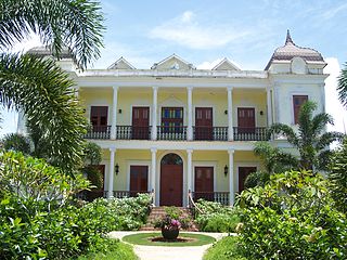
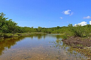
Playa Barrio is a rural barrio in the municipality of Guayanilla, Puerto Rico. Its population in 2010 was 1,186.

<span class="mw-page-title-main">Encarnación, Peñuelas, Puerto Rico</span> Barrio of Puerto Rico

Encarnación is a barrio in the municipality of Peñuelas, Puerto Rico. Its population in 2010 was 1,378.

<span class="mw-page-title-main">Santo Domingo, Peñuelas, Puerto Rico</span> Barrio of Puerto Rico

Santo Domingo is a barrio in the municipality of Peñuelas, Puerto Rico. Its population in 2010 was 5,761.

<span class="mw-page-title-main">Ángeles, Utuado, Puerto Rico</span> Barrio of Puerto Rico

Ángeles is a barrio in the municipality of Utuado, Puerto Rico. Its population in 2010 was 3,056.

<span class="mw-page-title-main">Viví Arriba</span> Barrio of Utuado, Puerto Rico

Viví Arriba is a barrio in the municipality of Utuado, Puerto Rico. Its population in 2010 was 748.

<span class="mw-page-title-main">Santa Isabel, Utuado, Puerto Rico</span> Barrio of Puerto Rico

Santa Isabel is a barrio in the municipality of Utuado, Puerto Rico. Its population in 2010 was 660.

<span class="mw-page-title-main">Boca, Guayanilla, Puerto Rico</span> Barrio of Puerto Rico

Boca is a rural barrio in the municipality of Guayanilla, Puerto Rico. Its population in 2010 was 1,089.

<span class="mw-page-title-main">Llano, Guayanilla, Puerto Rico</span> Barrio of Puerto Rico

Llano is a rural barrio in the municipality of Guayanilla, Puerto Rico. Its population in 2010 was 773.

<span class="mw-page-title-main">Magas, Guayanilla, Puerto Rico</span> Barrio of Puerto Rico

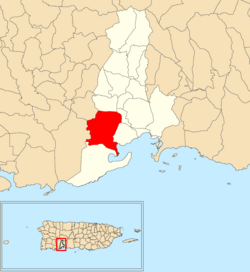
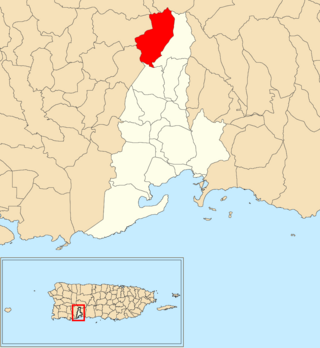
Magas is a rural barrio with an urban area in the municipality of Guayanilla, Puerto Rico. Its population in 2010 was 3,436.

<span class="mw-page-title-main">Rufina, Guayanilla, Puerto Rico</span> Barrio of Puerto Rico

Rufina is a rural barrio in the municipality of Guayanilla, Puerto Rico. Its population in 2010 was 220. Rufina was established in 1935 and was made up of parts of Guayanilla barrio-pueblo and Indios barrio in Guayanilla.

<span class="mw-page-title-main">Sierra Baja</span> Barrio of Guayanilla, Puerto Rico

Sierra Baja is a rural barrio in the municipality of Guayanilla, Puerto Rico. Its population in 2010 was 602.

<span class="mw-page-title-main">Quebradas, Guayanilla, Puerto Rico</span> Barrio of Puerto Rico

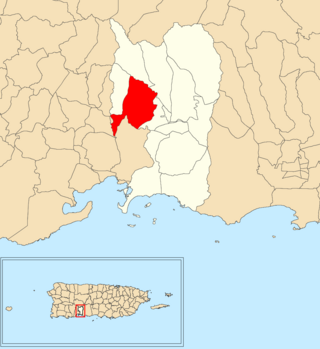
Quebradas is a rural barrio in the municipality of Guayanilla, Puerto Rico. Its population in 2010 was 2,425.

<span class="mw-page-title-main">Quebrada Arenas, Maunabo, Puerto Rico</span> Barrio of Puerto Rico

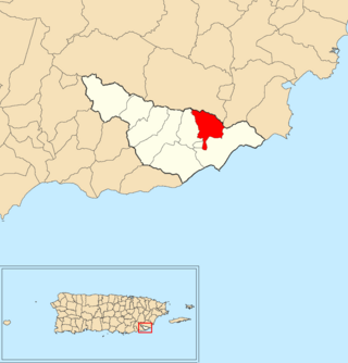
Quebrada Arenas is a barrio in the municipality of Maunabo, Puerto Rico. Its population in 2010 was 1,667.

<span class="mw-page-title-main">Tomás de Castro, Caguas, Puerto Rico</span> Barrio of Puerto Rico

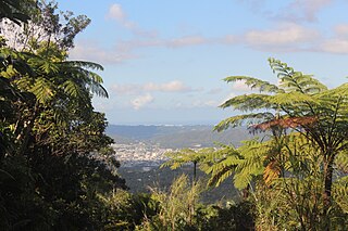
Tomás de Castro is a barrio in the municipality of Caguas, Puerto Rico. Its population in 2010 was 19,414.

References

  1. 1 2 "US Gazetteer 2019". US Census. US Government.
  2. U.S. Geological Survey Geographic Names Information System: Indios barrio
  3. Picó, Rafael; Buitrago de Santiago, Zayda; Berrios, Hector H. Nueva geografía de Puerto Rico: física, económica, y social, por Rafael Picó. Con la colaboración de Zayda Buitrago de Santiago y Héctor H. Berrios. San Juan Editorial Universitaria, Universidad de Puerto Rico,1969.
  4. Gwillim Law (20 May 2015). Administrative Subdivisions of Countries: A Comprehensive World Reference, 1900 through 1998. McFarland. p. 300. ISBN   978-1-4766-0447-3 . Retrieved 25 December 2018.
  5. Puerto Rico: 2010 population and housing unit counts.pdf (PDF). U.S. Dept. of Commerce, Economics and Statistics Administration, U.S. Census Bureau. 2010.
  6. "Report of the Census of Porto Rico 1899". War Department Office Director Census of Porto Rico. Archived from the original on July 16, 2017. Retrieved September 21, 2017.
  7. "Table 3-Population of Municipalities: 1930 1920 and 1910" (PDF). United States Census Bureau. Archived (PDF) from the original on August 17, 2017. Retrieved September 21, 2017.
  8. "Table 4-Area and Population of Municipalities Urban and Rural: 1930 to 1950" (PDF). United States Census Bureau. Archived (PDF) from the original on August 30, 2015. Retrieved September 21, 2014.
  9. "Table 2 Population and Housing Units: 1960 to 2000" (PDF). United States Census Bureau. Archived (PDF) from the original on July 24, 2017. Retrieved September 21, 2017.
  10. Puerto Rico: 2010 Population and Housing Unit Counts.pdf (PDF). U.S. Dept. of Commerce Economics and Statistics Administration U.S. Census Bureau. 2010. Archived (PDF) from the original on 2017-02-20. Retrieved 2019-08-02.
  11. "Anuario del comercio, de la industria, de la magistratura y de la administración. 1881". Biblioteca Nacional de España (in Spanish). p. 1614. Retrieved 4 April 2023.
  12. Joseph Prentiss Sanger; Henry Gannett; Walter Francis Willcox (1900). Informe sobre el censo de Puerto Rico, 1899, United States. War Dept. Porto Rico Census Office (in Spanish). Imprenta del gobierno. p.  165.
  13. "2020 Puerto Rico Earthquake Sequence (as of Jan. 16, 2020)". www.usgs.gov.