Orocovis, Puerto Rico

Last updated

Orocovis
Municipio de Orocovis
Salto Dona Juana, Orocovis, Puerto Rico.jpg
Salto de Doña Juana waterfall in Orocovis
Flag of Orocovis, Puerto Rico.svg
Coat of arms of Orocovis, Puerto Rico.svg
Nicknames: 
"Corazón de Puerto Rico", "El Centro Geográfico de Puerto Rico"
Anthem: "Mi patria es una bella isla"
Locator-map-Puerto-Rico-Orocovis.svg
Map of Puerto Rico highlighting Orocovis Municipality
Coordinates: 18°13′37″N66°23′28″W / 18.22694°N 66.39111°W / 18.22694; -66.39111
Commonwealth Flag of Puerto Rico.svg  Puerto Rico
FoundedNovember 10, 1825
FounderJuan Rivera de Santiago
Barrios
Government
   Mayor Jesús E. Colón Berlingeri (PNP)
  Senatorial dist. 5 - Ponce
  Representative dist.26
Area
  Total71.1 sq mi (184.17 km2)
  Land71.0 sq mi (184 km2)
  Water0.1 sq mi (0.17 km2)
Population
 (2020) [1]
  Total21,434
  Rank 58th in Puerto Rico
  Density300/sq mi (120/km2)
Demonym Orocoveños
Time zone UTC-4 (AST)
ZIP Code
00720
Area code 787/939
Major routes PR secondary 143.svg PR secondary 155.svg PR secondary 156.svg PR secondary 157.svg Ellipse sign 149.svg
Website www.orocovispr.org
Near the main plaza, 1941 Orocovis, Puerto Rico Near the main plaza 1941.jpg
Near the main plaza, 1941

Orocovis (from the Taino chief Orocobix) is a town and municipality of Puerto Rico located in the center of the island. Founded by Juan Rivera de Santiago in 1825. Orocovis is spread over 17 barrios. It is part of the San Juan-Caguas-Guaynabo Metropolitan Statistical Area. It's located north of Villalba and Coamo; south of Morovis and Corozal; southeast of Ciales; east of Jayuya; and west of Barranquitas

Contents

History

Since before the Spanish colonization in the 16th century, the Taíno were already established in the region. They were led by the cacique Orocobix and his tribe known as the Jatibonicu. After Spaniards settled in the island, the region was part of the south of Manatí and the north region of Coamo. By 1823 Orocovis was a barrio of Barranquitas while Morovis (previously part of Manatí) had a barrio called Barros. Both Orocovis and Barros were eventually united to establish a new town.

In early 1825, Juan Rivera de Santiago sought and obtained legal power by the neighbors of the region to request the Governor authorization to found a municipality in the Barros area, where they had bought 14 acres of land from Eulalia (Olaya) de Rivera Melendez, who donated an additional acre to establish several municipal works. However, due to the distance from bodies of water, the settlement was moved to another place where it is today. On November 10, 1825, Governor Miguel de la Torre granted permission to found the new municipality of Barros.

In 1838, the parish of San Juan Bautista de Barros was created and was blessed and inaugurated on October 29 of the same year. However, in 1875, a fire destroyed the church, the King's House, the priest's house and several homes.

Most of Orocovis nicknames stem from its location in the center of the island. Some of them are: "Corazón de Puerto Rico" (Heart of Puerto Rico) and "Centro Geográfico de Puerto Rico" (Geographical Center of Puerto Rico). Locals say the center of Puerto Rico is in a barrio called Pellejas, on Road 566, Km 5.7 in Orocovis. That the center of Puerto Rico is in front of the Catholic church was determined to be false by engineers from the University of Puerto Rico, Mayagüez Campus.[ citation needed ]

Puerto Rico was ceded by Spain in the aftermath of the Spanish–American War under the terms of the Treaty of Paris of 1898 and became a territory of the United States. In 1899, the United States Department of War conducted a census of Puerto Rico finding that the population of Barros, as Orocovis was then called, was 14,845. [2]

In 1928, the Legislative Assembly of Puerto Rico approved a resolution to change the name of Barros to Orocovis, to honor the Taíno cacique of the same name, who lived in that region.

Geography

The municipality Orocovis is mountainous with many valleys. Most of the Orocovis terrain runs through the Cordillera Central of the island. Most of the high peaks are in the southern region of the municipality within the limits of the municipality with Villalba and Coamo. The highest peak of the town is Cerro Mogote. [3]

The rivers Toro Negro, Sana Muertos, Orocovis, Matrullas, and Bauta, and the creeks Doña Juana, Palmar and Cacaos are among the water bodies in the town. There are two lakes: El Guineo, a reservoir of the Toro Negro River, and the Matrullas Lake formed by the Bauta River. El Guineo is Puerto Rico's highest lake. [4]

Barrios

Subdivisions of Orocovis. Orocovis, Puerto Rico locator map.png
Subdivisions of Orocovis.

Like all municipalities of Puerto Rico, Orocovis is subdivided into barrios. The municipal buildings, central square and large Catholic church are located in a barrio referred to as "el pueblo". [5] [6]

Sectors

Barrios (which are, in contemporary times, roughly comparable to minor civil divisions) [7] and subbarrios, [8] are further subdivided into smaller areas called sectores (sectors in English). The types of sectores may vary, from normally sector to urbanización to reparto to barriada to residencial, among others. [9] [10] [11]

Special Communities

Comunidades Especiales de Puerto Rico (Special Communities of Puerto Rico) are marginalized communities whose citizens are experiencing a certain amount of social exclusion. A map shows these communities occur in nearly every municipality of the commonwealth. Of the 742 places that were on the list in 2014, the following barrios, communities, sectors, or neighborhoods were in Orocovis: Ala de la Piedra, Alturas de Orocovis, Cacao, Sector Parcelas in Botijas 1, Botijas II, Comunidad Miraflores [12] and La Pica (Luis M. Alfaro). [13]

Energy consortium

An Energy Consortium was signed in late February, 2019 by Villalba, Orocovis, Morovis, Ciales and Barranquitas municipalities. The consortium is the first of its kind for the island. It is intended to have municipalities work together to safeguard and create resilient, and efficient energy networks, with backups for their communities. [14]

Culture

"The Musical Capital of Puerto Rico"

Orocovis is sometimes called "The Musical Capital of Puerto Rico" because many major Puerto Rican performers were either born or raised in the town, particularly bandleader Bobby Valentín, folk singer Andrés Jiménez, merengue singer Manny Manuel, salsa legend William "H. Christ" Corchado, and the Colón-Zayas family of musicians, which includes Emma (singer, multi-instrumentalist) and Edwin (a cuatro player).

Santo (art figurines)

Santo by Tiburcio de la Espada from San German, Puerto Rico San Jose y el Nino Santo statuette by Tiburcio de la Espada from Puerto Rico.jpg
Santo by Tiburcio de la Espada from San Germán, Puerto Rico

Celestino Avilés Meléndez (1925-2004), a santero from Orocovis, saved the dying art from his workshop. Santeros are folk artists who create wooden, religious statuettes called Santos . [15] The folk artists were dispersed around Puerto Rico and were few in number. Avilés' initiative, in 1983, for santeros to meet continues to this day with the Encuentro Nacional de Santeros taking place in Orocovis, the third week in December annually. Also, Avilés' establishing the Museo Orocoveño Familia Avilés Inc. in 1982, a museum for santeros art, revived the culture and art of santeros and santos and by 2019, there were more than 300 santeros making santos in Puerto Rico. [16]

Tourism

View of Orocovis from lookout in Orocovis View from lookout in Orocovis, Puerto Rico.jpg
View of Orocovis from lookout in Orocovis

Landmarks and places of interest

Lookout in Orocovis, Puerto Rico Lookout in Orocovis, Puerto Rico.jpg
Lookout in Orocovis, Puerto Rico

"El Monstruo" at Toro Verde Nature Adventure Park in Orocovis came in third for longest zip line in the world in 2018, at 2530 m (8,300 ft). [17]

Festivals and events

Orocovis celebrates its patron saint festival in June. The Fiestas Patronales de San Juan Bautista is a religious and cultural celebration that generally features parades, games, artisans, amusement rides, regional food, and live entertainment. [3] [19] [20]

Other festivals and events celebrated in Orocovis include:

Economy

Agriculture

Cattle, coffee, fruits, tobacco, and wheat. A young business growing hydroponics lettuce was in negotiations to be a supplier for Walmart in 2019. [21]

Industrial

Several small nutritional product industries.

Demographics

Historical population
CensusPop.Note
1900 14,845
1910 15,0281.2%
1920 15,7584.9%
1930 16,1152.3%
1940 19,77022.7%
1950 21,1817.1%
1960 20,362−3.9%
1970 20,201−0.8%
1980 19,332−4.3%
1990 21,1589.4%
2000 23,84412.7%
2010 23,423−1.8%
2020 21,434−8.5%
U.S. Decennial Census [22]
1899 (shown as 1900) [23] 1910-1930 [24]
1930-1950 [25] 1960-2000 [26] 2010 [27] 2020 [28]

According to the 2000 census, Orocovis has a population of 23,844 with a population density is 378.4 people per square mile (145.5/km2). Although there was a decline in the population during the 1980s, it has steadily increased during the last decades.

Statistics taken from the 2000 census shows that 81.4% of Orocoveños have Spanish or White origin, 4.1% are black, 0.4% are Amerindian etc.

Race - Orocovis, Puerto Rico - 2000 Census [29]
RacePopulation % of Total
White 19,40181.4%
Black/African American 9754.1%
American Indian and Alaska Native 870.4%
Asian 150.1%
Native Hawaiian/Pacific Islander 50.0%
Some other race2,61811.0%
Two or more races7433.1%

Government

All municipalities in Puerto Rico are administered by a mayor, elected every four years. Jesús Colón Berlingeri (of the New Progressive Party) has served as mayor since 1998.

The city belongs to the Puerto Rico Senatorial district VI, which is represented by two senators. In 2012, Miguel Pereira Castillo and Angel M. Rodríguez were elected as district senators. [30]

Education

Orocovis has several public and private schools and public education is administered by the Puerto Rico Department of Education.

Transportation

There is no direct highway connection to Orocovis. Roads #137 and #155 lead from the north, while roads #138 and #155 lead from the south. Orocovis lies at about an hour and a half from San Juan, the capital of Puerto Rico.

There are 17 bridges in Orocovis. [31]

Symbols

The municipio has an official flag and coat of arms. [32]

Flag of Orocovis

The Flag of Orocovis is formed by five vertical stripes: Two green stripes at the ends, representing the territories of Aibonito and Barranquitas; and a blue one in the center representing the regional domain of the cacique Orocobix prior to the Spanish colonization. These stripes are divided by two narrower white stripes, representing the territories granted by Barranquitas and Morovis to form the municipality in 1825. [33]

Over the blue portion there's an oval with a Sun. The Sun has seventeen rays that represent the different regions of the town. The Sun, being the center of the Solar System, represents Orocovis as the center of the island of Puerto Rico. [33]

Coat of arms

The oval is symbol of the letter "O", initial of the name of the town. In each quadrant appear representative elements of the town. In the left superior quadrant a Taíno Indian bust, symbol of the great "Chief Orocobix" and the Indian heritage of the town, silhouetted in gold on a silver-plated background. The Indian bust faces to the star or sun that appears in the superior right quadrant, which is in gold on a blue background and represents the territorial municipality with its seventeen rays or demarcations. In the inferior right quadrant, a plantain plant is observed representing the agriculture, silhouetted in gold on a silver-plated background. A bridge also silhouetted in gold on a blue background, above the river appears in the left inferior quadrant. [33]

See also

Related Research Articles

<span class="mw-page-title-main">Coamo, Puerto Rico</span> Town and municipality in Puerto Rico

Coamo is a town and municipality founded in 1579 in the south-central region of Puerto Rico, located north of Santa Isabel; south of Orocovis and Barranquitas; east of Villalba and Juana Díaz; and west of Aibonito and Salinas. The municipality of Coamo is spread over 10 barrios and Coamo Pueblo – the town or downtown area and administrative center of the city. The Coamo municipality is also a Micropolitan Statistical Area and as such is part of the Ponce-Yauco-Coamo Combined Statistical Area.

<span class="mw-page-title-main">Barranquitas, Puerto Rico</span> Town and municipality in Puerto Rico

Barranquitas is a small mountain town and municipality located in the Cordillera Central region of Puerto Rico, south of Corozal and Naranjito; north of Coamo and Aibonito; west of Comerío and Cidra; and east of Orocovis. Barranquitas is spread over 6 barrios and Barranquitas Pueblo. It is part of the San Juan-Caguas-Guaynabo Metropolitan Statistical Area.

<span class="mw-page-title-main">Ciales, Puerto Rico</span> Town and municipality of Puerto Rico

Ciales is a town and municipality of Puerto Rico, located on the Central Mountain Range, northwest of Orocovis; south of Florida and Manatí; east of Utuado and Jayuya; and west of Morovis. Ciales is spread over eight barrios and Ciales Pueblo. It is part of the San Juan-Caguas-Guaynabo Metropolitan Statistical Area.

<span class="mw-page-title-main">Corozal, Puerto Rico</span> Town and municipality in Puerto Rico

Corozal is a town and municipality of Puerto Rico located in the central-eastern region, north of Orocovis and Barranquitas; south of Vega Alta; southwest of Toa Alta; east of Morovis and Orocovis; and west of Naranjito. Corozal is spread over 12 barrios and Corozal Pueblo. It is part of the San Juan-Caguas-Guaynabo Metropolitan Statistical Area.

<span class="mw-page-title-main">Juana Díaz, Puerto Rico</span> City and municipality in Puerto Rico

Juana Díaz is a town and municipality of Puerto Rico located on the southern coast of the island, south of Jayuya, Ciales, Orocovis and Villalba; east of Ponce; and west of Coamo and Santa Isabel and the Caribbean Sea to the south. Juana Díaz is spread over 13 barrios and Juana Diaz Pueblo. It is part of the Ponce Metropolitan Statistical Area.

<span class="mw-page-title-main">Morovis, Puerto Rico</span> Town and municipality in Puerto Rico

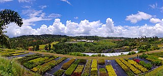
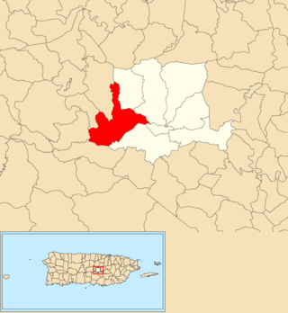
Morovis is a town and municipality of Puerto Rico located in the central region of the island, north of Orocovis, south of Manatí, Vega Baja and Vega Alta; east of Ciales, and west of Corozal. Morovis is spread over 13 barrios and Morovis Pueblo. It is part of the San Juan-Caguas-Guaynabo Metropolitan Statistical Area.

<span class="mw-page-title-main">Villalba, Puerto Rico</span> Town and municipality in Puerto Rico

Villalba, originally known as Villa Alba, is a town and municipality of Puerto Rico located in the central region, northeast of Juana Díaz; south of Orocovis; and west of Coamo. Villalba is spread over 6 barrios and Villalba Pueblo. It is part of the Ponce Metropolitan Statistical Area.

Orocobix was the principal regional Taíno Cacique (chief) of the central mountain region of Puerto Rico called Jatibonicu in the 16th century. The Jatibonicu territorial region covered the present day municipalities of Aibonito, Orocovis, Barranquitas, Morovis and Corozal. The Taíno language name Orocobix or O-roco-bis literally means: 'Remembrance of the First Great Mountain.'

<span class="mw-page-title-main">Puerto Rico Highway 143</span> Highway in Puerto Rico

Puerto Rico Highway 143 (PR-143) is a secondary highway that connects the town of Adjuntas to the town of Barranquitas.

<span class="mw-page-title-main">Palo Hincado, Barranquitas, Puerto Rico</span> Barrio of Puerto Rico

Palo Hincado is a barrio in the municipality of Barranquitas, Puerto Rico. Its population in 2010 was 4,587.

<span class="mw-page-title-main">Orocovis barrio-pueblo</span> Historical and administrative center (seat) of Orocovis, Puerto Rico

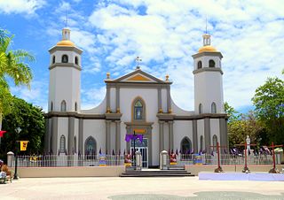
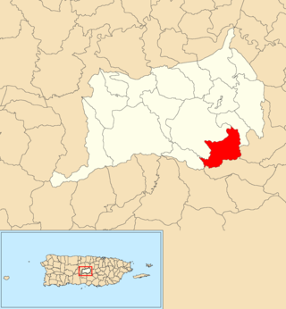
Barrio Pueblo is a barrio and the administrative center (seat) of Orocovis, a municipality of Puerto Rico. Its population in 2010 was 682.

<span class="mw-page-title-main">Pasto, Morovis, Puerto Rico</span> Barrio of Puerto Rico

Pasto is a barrio in the municipality of Morovis, Puerto Rico. Pasto has about 8 sectors and its population in 2010 was 767.

<span class="mw-page-title-main">Río Grande, Morovis, Puerto Rico</span> Barrio of Puerto Rico

Río Grande is a barrio in the municipality of Morovis, Puerto Rico. Río Grande has six sectors and its population in 2010 was 594.

<span class="mw-page-title-main">Fránquez, Morovis, Puerto Rico</span> Barrio of Puerto Rico

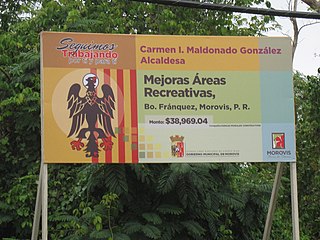
Fránquez is a barrio in the municipality of Morovis, Puerto Rico. Fránquez has twelve sectors and its population in 2010 was 4,583.

<span class="mw-page-title-main">Barros, Orocovis, Puerto Rico</span> Barrio of Puerto Rico

Barros is a barrio in the municipality of Orocovis, Puerto Rico. Its population in 2010 was 1,917.

<span class="mw-page-title-main">Bauta Abajo</span> Barrio of Orocovis, Puerto Rico

Bauta Abajo is a barrio in the municipality of Orocovis, Puerto Rico. Its population in 2010 was 1,516.

<span class="mw-page-title-main">Orocovis, Orocovis, Puerto Rico</span> Barrio of Puerto Rico

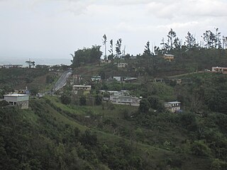
Orocovis is a barrio in the municipality of Orocovis, Puerto Rico. Its population in 2010 was 3,658.

<span class="mw-page-title-main">Bauta Arriba</span> Barrio of Orocovis, Puerto Rico

Bauta Arriba is a barrio in the municipality of Orocovis, Puerto Rico. Its population in 2010 was 913.

References

  1. Bureau, US Census. "PUERTO RICO: 2020 Census". The United States Census Bureau. Retrieved August 25, 2021.
  2. Joseph Prentiss Sanger; Henry Gannett; Walter Francis Willcox (1900). Informe sobre el censo de Puerto Rico, 1899, United States. War Dept. Porto Rico Census Office. Imprenta del gobierno. p. 162.
  3. 1 2 "Orocovis Municipality". enciclopediapr.org. Fundación Puertorriqueña de las Humanidades (FPH). Archived from the original on August 22, 2020. Retrieved March 20, 2019.
  4. PR Off the Beaten Path. Page 156
  5. Gwillim Law (May 20, 2015). Administrative Subdivisions of Countries: A Comprehensive World Reference, 1900 through 1998. McFarland. p. 300. ISBN   978-1-4766-0447-3 . Retrieved December 25, 2018.
  6. "Map of Orocovis at the Wayback Machine" (PDF). Archived from the original (PDF) on March 24, 2018. Retrieved December 29, 2018.
  7. "US Census Barrio-Pueblo definition". factfinder.com. US Census. Archived from the original on May 13, 2017. Retrieved January 5, 2019.
  8. "P.L. 94-171 VTD/SLD Reference Map (2010 Census): Orocovis Municipio, PR" (PDF). www2.census.gov. U.S. DEPARTMENT OF COMMERCE Economics and Statistics Administration U.S. Census Bureau. Archived (PDF) from the original on August 22, 2020. Retrieved August 22, 2020.
  9. "Agencia: Oficina del Coordinador General para el Financiamiento Socioeconómico y la Autogestión (Proposed 2016 Budget)". Puerto Rico Budgets (in Spanish). Archived from the original on June 28, 2019. Retrieved June 28, 2019.
  10. Rivera Quintero, Marcia (2014), El vuelo de la esperanza: Proyecto de las Comunidades Especiales Puerto Rico, 1997-2004 (first ed.), San Juan, Puerto Rico Fundación Sila M. Calderón, ISBN   978-0-9820806-1-0
  11. "Leyes del 2001". Lex Juris Puerto Rico (in Spanish). Archived from the original on September 14, 2018. Retrieved June 24, 2020.
  12. "Miraflores: promoting a community development model". El Nuevo Día. October 18, 2019. Retrieved September 9, 2020.
  13. Rivera Quintero, Marcia (2014), El vuelo de la esperanza:Proyecto de las Comunidades Especiales Puerto Rico, 1997-2004 (Primera edición ed.), San Juan, Puerto Rico Fundación Sila M. Calderón, p. 273, ISBN   978-0-9820806-1-0
  14. Vazquez, Priscilla. "Asociación de Industriales de Puerto Rico". Industriales Puerto Rico. Archived from the original on March 12, 2019. Retrieved March 16, 2019.
  15. Cooper Union Museum for the Arts of Decoration; Lesley, Everett Parker (June 17, 2019). "Santos from Puerto Rico : [exhibition catalog]". [New York : Cooper Union]. Retrieved June 17, 2019 via Internet Archive.
  16. "Celestino Avilés". MUSAN (in Spanish). January 20, 2021. Retrieved August 24, 2021.
  17. Abney, Clay (May 10, 2018). "Take flight on the 3 longest zip-lines in the world". The Manual. Archived from the original on January 25, 2019. Retrieved January 25, 2019.
  18. "Cascada Chorro de Doña Juana". Discover Puerto Rico. Retrieved October 2, 2023.
  19. "Puerto Rico Festivales, Eventos y Actividades en Puerto Rico". Puerto Rico Hoteles y Paradores (in Spanish). Archived from the original on February 26, 2020. Retrieved July 17, 2020.
  20. J.D. (May 2, 2006). "Orocovis". Link To Puerto Rico.com (in Spanish). Archived from the original on February 24, 2013. Retrieved July 18, 2020.
  21. "Matrimonio comparte su historia de éxito del cultivo de lechugas en Orocovis". Primera Hora (in Spanish). May 12, 2019. Archived from the original on May 13, 2019. Retrieved May 13, 2019.
  22. "U.S. Decennial Census". United States Census Bureau. Archived from the original on February 13, 2020. Retrieved September 21, 2017.
  23. "Report of the Census of Porto Rico 1899". War Department, Office Director Census of Porto Rico. Archived from the original on July 16, 2017. Retrieved September 21, 2017.
  24. "Table 3-Population of Municipalities: 1930, 1920, and 1910" (PDF). United States Census Bureau. Archived (PDF) from the original on August 17, 2017. Retrieved September 21, 2017.
  25. "Table 4-Area and Population of Municipalities, Urban and Rural: 1930 to 1950" (PDF). United States Census Bureau. Archived (PDF) from the original on August 30, 2015. Retrieved September 21, 2014.
  26. "Table 2 Population and Housing Units: 1960 to 2000" (PDF). United States Census Bureau. Archived (PDF) from the original on July 24, 2017. Retrieved September 21, 2017.
  27. Puerto Rico:2010:population and housing unit counts.pdf (PDF). U.S. Dept. of Commerce, Economics and Statistics Administration, U.S. Census Bureau. 2010. Archived (PDF) from the original on February 20, 2017. Retrieved December 26, 2018.
  28. Bureau, US Census. "PUERTO RICO: 2020 Census". The United States Census Bureau. Retrieved August 25, 2021.
  29. "Ethnicity 2000 census" (PDF). Archived (PDF) from the original on February 16, 2008. Retrieved April 6, 2009.
  30. Elecciones Generales 2012: Escrutinio General Archived 2013-01-15 at the Wayback Machine on CEEPUR
  31. "Orocovis Bridges". National Bridge Inventory Data. US Dept. of Transportation. Archived from the original on February 20, 2019. Retrieved February 19, 2019.
  32. "Ley Núm. 70 de 2006 -Ley para disponer la oficialidad de la bandera y el escudo de los setenta y ocho (78) municipios". LexJuris de Puerto Rico (in Spanish). Retrieved June 15, 2021.
  33. 1 2 3 "OROCOVIS". LexJuris (Leyes y Jurisprudencia) de Puerto Rico (in Spanish). February 19, 2020. Archived from the original on February 19, 2020. Retrieved September 17, 2020.

Further reading