Barahona, Morovis, Puerto Rico

Last updated
Barahona
Barrio
Building on Puerto Rico Highway 633 in Barahona, Morovis.jpg
Building in Barahona
Barahona, Morovis, Puerto Rico locator map.png
Location of Barahona within the municipality of Morovis shown in red
Caribbean location map.svg
Red pog.svg
Barahona
Location of Puerto Rico
Coordinates: 18°21′43″N66°26′50″W / 18.362065°N 66.447307°W / 18.362065; -66.447307 [1]
Commonwealth Flag of Puerto Rico.svg  Puerto Rico
Municipality Bandera de Morovis, Puerto Rico.svg Morovis
Area
[1]
  Total3.76 sq mi (9.7 km2)
  Land3.76 sq mi (9.7 km2)
  Water0 sq mi (0 km2)
Elevation
[2]
561 ft (171 m)
Population
 (2010)
  Total5,244
  Density1,398.4/sq mi (539.9/km2)
 Source: 2010 Census
Time zone UTC−4 (AST)
Zip code
00687

Barahona is a barrio in the municipality of Morovis, Puerto Rico. Barahona has thirteen sectors and its population in 2010 was 5,244. [3] [4] [5]

Contents

History

Barahona was in Spain's gazetteers [6] until Puerto Rico was ceded by Spain in the aftermath of the Spanish–American War under the terms of the Treaty of Paris of 1898 and became an unincorporated territory of the United States. In 1899, the United States Department of War conducted a census of Puerto Rico finding that the population of Barahona barrio was 854. [7]

Historical population
CensusPop.Note
1900 854
1910 1,02419.9%
1920 1,35732.5%
1930 1,50310.8%
1940 1,430−4.9%
1950 1,89932.8%
1960 1,660−12.6%
1970 2,03522.6%
1980 2,91443.2%
1990 3,81430.9%
2000 4,41015.6%
2010 5,24418.9%
U.S. Decennial Census
1899 (shown as 1900) [8] 1910-1930 [9]
1930-1950 [10] 1980-2000 [11] 2010 [12]

After Hurricane Maria destroyed critical infrastructure in Puerto Rico on September 20, 2017, the Puerto Rico National Guard was tasked with providing people with potable water.

Sectors

Barrios (which are, in contemporary times, roughly comparable to minor civil divisions) [13] in turn are further subdivided into smaller local populated place areas/units called sectores (sectors in English). The types of sectores may vary, from normally sector to urbanización to reparto to barriada to residencial, among others. [14] [15] [16]

The following sectors are in Barahona barrio: [17]

Carretera 633, Parcelas Barahona, Sector Cabachuelas I, Sector Germán Vega, Sector La Lomita, Sector Los Currás, Sector Siete Cuerdas, Sector VilLa Roca, Urbanización Brisas de Barahona, Urbanización Hacienda Las Marías, Urbanización Reparto Los Torres, Urbanización Valle San Luis, and Valle Barahona.

Education

Barrahona is home to the Ángel G. Quintero Middle School (Escuela Intermedia Ángel G. Quintero). [18]

See also

Related Research Articles

<span class="mw-page-title-main">Galateo, Toa Alta, Puerto Rico</span> Barrio of Puerto Rico

Galateo is a barrio in the municipality of Toa Alta, Puerto Rico. Its population in 2010 was 5,917.

<span class="mw-page-title-main">Quebrada Cruz</span> Barrio of Toa Alta, Puerto Rico

Quebrada Cruz is a barrio in the municipality of Toa Alta, Puerto Rico. Its population in 2010 was 5,343 living in over 30 sectors.

<span class="mw-page-title-main">Lavadero</span> Barrio of Hormigueros, Puerto Rico

Lavadero is a barrio in the municipality of Hormigueros, Puerto Rico. Its population in 2010 was 4,305.

<span class="mw-page-title-main">Caimital Alto, Aguadilla, Puerto Rico</span> Barrio of Puerto Rico

Caimital Alto is a barrio in the municipality of Aguadilla, Puerto Rico. Its population in 2010 was 3,989.

<span class="mw-page-title-main">Camaceyes, Aguadilla, Puerto Rico</span> Barrio of Puerto Rico

Camaceyes is a barrio in the municipality of Aguadilla, Puerto Rico. Its population in 2010 was 12,547. In Camaceyes barrio is part of the Aguadilla urban zone.

<span class="mw-page-title-main">Ceiba Baja, Aguadilla, Puerto Rico</span> Barrio of Puerto Rico

Ceiba Baja is a rural barrio in the municipality of Aguadilla, Puerto Rico. Its population in 2010 was 2,356.

<span class="mw-page-title-main">Aguacate, Aguadilla, Puerto Rico</span> Barrio of Puerto Rico

Aguacate is a barrio in the municipality of Aguadilla, Puerto Rico. Its population in 2010 was 1,525.

<span class="mw-page-title-main">Cuchillas, Morovis, Puerto Rico</span> Barrio of Puerto Rico

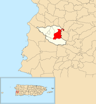
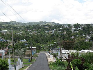
Cuchillas is a rural barrio in the municipality of Morovis, Puerto Rico. Cuchillas has fourteen sectors and its population in 2010 was 2,333.

<span class="mw-page-title-main">Monte Llano, Morovis, Puerto Rico</span> Barrio of Puerto Rico

Monte Llano is a barrio in the municipality of Morovis, Puerto Rico. Monte Llano has about 15 sectors and its population in 2010 was 2,948.

<span class="mw-page-title-main">Pasto, Morovis, Puerto Rico</span> Barrio of Puerto Rico

Pasto is a barrio in the municipality of Morovis, Puerto Rico. Pasto has about 8 sectors and its population in 2010 was 767.

<span class="mw-page-title-main">Río Grande, Morovis, Puerto Rico</span> Barrio of Puerto Rico

Río Grande is a barrio in the municipality of Morovis, Puerto Rico. Río Grande has six sectors and its population in 2010 was 594.

<span class="mw-page-title-main">Morovis barrio-pueblo</span> Historical and administrative center (seat) of Morovis, Puerto Rico

Morovis barrio-pueblo is a barrio and the administrative center (seat) of Morovis, a municipality of Puerto Rico. Morovis barrio-pueblo has about 12 sectors and its population in 2010 was 895.

<span class="mw-page-title-main">Factor, Arecibo, Puerto Rico</span> Barrio of Puerto Rico

Factor is a barrio in the municipality of Arecibo, Puerto Rico. Its population in 2010 was 8,001.

<span class="mw-page-title-main">Fránquez, Morovis, Puerto Rico</span> Barrio of Puerto Rico

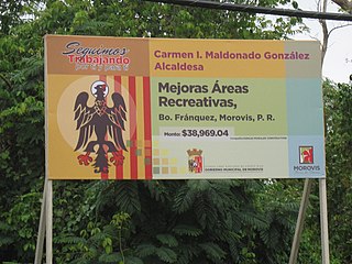
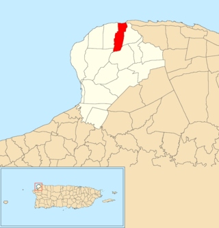
Fránquez is a barrio in the municipality of Morovis, Puerto Rico. Fránquez has twelve sectors and its population in 2010 was 4,583.

<span class="mw-page-title-main">Morovis Norte</span> Barrio of Morovis, Puerto Rico

Morovis Norte is a barrio in the municipality of Morovis, Puerto Rico. Morovis Norte has about 15 sectors and its population in 2010 was 3,546.

<span class="mw-page-title-main">Morovis Sud</span> Barrio of Morovis, Puerto Rico

Morovis Sud also called Morovis Sur is a barrio in the municipality of Morovis, Puerto Rico. Morovis Sud has about 14 sectors and its population in 2010 was 4,208.

<span class="mw-page-title-main">Torrecillas, Morovis, Puerto Rico</span> Barrio of Puerto Rico

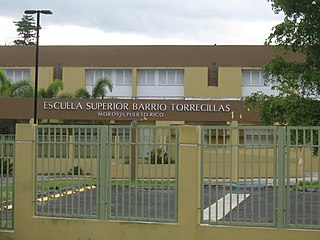
Torrecillas is a barrio in the municipality of Morovis, Puerto Rico. Torrecillas has eight sectors and its population in 2010 was 623. A USDA Rural Development field office is located in Torrecillas.

<span class="mw-page-title-main">Unibón</span> Barrio of Morovis, Puerto Rico

Unibón is a barrio in the municipality of Morovis, Puerto Rico. Unibón has fifteen sectors and its population in 2010 was 3,853.

<span class="mw-page-title-main">Vaga, Morovis, Puerto Rico</span> Barrio of Puerto Rico

Vaga is a barrio in the municipality of Morovis, Puerto Rico. Vaga has three sectors and its population in 2010 was 471.

<span class="mw-page-title-main">Orocovis, Orocovis, Puerto Rico</span> Barrio of Puerto Rico

Orocovis is a barrio in the municipality of Orocovis, Puerto Rico. Its population in 2010 was 3,658.

References

  1. 1 2 "US Gazetteer 2019". US Census. US Government.
  2. U.S. Geological Survey Geographic Names Information System: Barahona barrio
  3. Picó, Rafael; Buitrago de Santiago, Zayda; Berrios, Hector H. Nueva geografía de Puerto Rico: física, económica, y social, por Rafael Picó. Con la colaboración de Zayda Buitrago de Santiago y Héctor H. Berrios. San Juan Editorial Universitaria, Universidad de Puerto Rico,1969.
  4. Gwillim Law (20 May 2015). Administrative Subdivisions of Countries: A Comprehensive World Reference, 1900 through 1998. McFarland. p. 300. ISBN   978-1-4766-0447-3 . Retrieved 25 December 2018.
  5. Puerto Rico: 2010 Population and Housing Unit Counts.pdf (PDF). U.S. Dept. of Commerce, Economics and Statistics Administration, U.S. Census Bureau. 2010.
  6. "Anuario del comercio, de la industria, de la magistratura y de la administración. 1881". Biblioteca Nacional de España (in Spanish). p. 1614. Retrieved 4 April 2023.
  7. Joseph Prentiss Sanger; Henry Gannett; Walter Francis Willcox (1900). Informe sobre el censo de Puerto Rico, 1899, United States. War Dept. Porto Rico Census Office (in Spanish). Imprenta del gobierno. p.  161.
  8. "Report of the Census of Porto Rico 1899". War Department Office Director Census of Porto Rico. Archived from the original on July 16, 2017. Retrieved September 21, 2017.
  9. "Table 3-Population of Municipalities: 1930 1920 and 1910" (PDF). United States Census Bureau. Archived (PDF) from the original on August 17, 2017. Retrieved September 21, 2017.
  10. "Table 4-Area and Population of Municipalities Urban and Rural: 1930 to 1950" (PDF). United States Census Bureau. Archived (PDF) from the original on August 30, 2015. Retrieved September 21, 2014.
  11. "Table 2 Population and Housing Units: 1960 to 2000" (PDF). United States Census Bureau. Archived (PDF) from the original on July 24, 2017. Retrieved September 21, 2017.
  12. Puerto Rico: 2010 Population and Housing Unit Counts.pdf (PDF). U.S. Dept. of Commerce Economics and Statistics Administration U.S. Census Bureau. 2010. Archived (PDF) from the original on 2017-02-20. Retrieved 2019-08-02.
  13. "US Census Barrio-Pueblo definition". factfinder.com. US Census. Archived from the original on 13 May 2017. Retrieved 5 January 2019.
  14. "Agencia: Oficina del Coordinador General para el Financiamiento Socioeconómico y la Autogestión (Proposed 2016 Budget)". Puerto Rico Budgets (in Spanish). Retrieved 28 June 2019.
  15. Rivera Quintero, Marcia (2014), El vuelo de la esperanza: Proyecto de las Comunidades Especiales Puerto Rico, 1997-2004 (first ed.), San Juan, Puerto Rico Fundación Sila M. Calderón, ISBN   978-0-9820806-1-0
  16. "Leyes del 2001". Lex Juris Puerto Rico (in Spanish). Retrieved 24 June 2020.
  17. "PRECINTO ELECTORAL MOROVIS 020" (PDF). Comisión Estatal de Elecciones (in Spanish). PR Government. 8 October 2019. Archived from the original (PDF) on 15 June 2020. Retrieved 24 June 2020.
  18. "Search for Public Schools - ANGEL G QUINTERO ALFARO (720003000131)". National Center for Education Statistics (NCES) Home Page, a part of the U.S. Department of Education. Retrieved 24 March 2023.