Lares barrio-pueblo is a barrio and the administrative center (seat) of Lares, a municipality of Puerto Rico. Its population in 2010 was 2,690.[1][4][5][6]
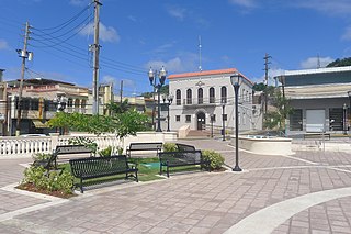
As was customary in Spain, in Puerto Rico, the municipality has a barrio called pueblo which contains a central plaza, the municipal buildings (city hall), and a Catholic church. Fiestas patronales (patron saint festivals) are held in the central plaza every year.[7][8]
The central plaza and its church
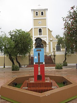
Plaza de la Revolución is the name of the central plaza located in Lares Barrio Pueblo.[9] The central plaza, or square, is a place for official and unofficial recreational events and a place where people can gather and socialize from dusk to dawn. The Laws of the Indies, Spanish law, which regulated life in Puerto Rico in the early 19th century, stated the plaza's purpose was for "the parties" (celebrations, festivities) (Spanish: a propósito para las fiestas), and that the square should be proportionally large enough for the number of neighbors (Spanish: grandeza proporcionada al número de vecinos). These Spanish regulations also stated that the streets nearby should be comfortable portals for passersby, protecting them from the elements: sun and rain.[7]
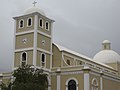
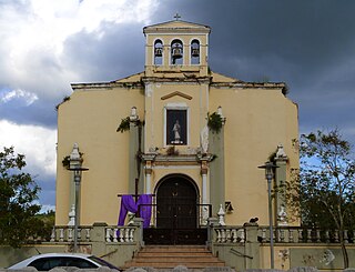
Located across the central plaza in Lares barrio-pueblo is the Parroquia San José (English: Church San José of Lares), a Roman Catholic church.[10] Originally made of wood, it was inaugurated in 1838. In 1881, it was remade based on a design by Ramón Soler with stone masonry but with wooden towers and a wooden roof. Then in the 1920s it was remodeled again. The building has changed completely but the original lateral walls and the first level of its front facade also remain from the original.[11]
U.S. Decennial Census 1899 (shown as 1900)[14] 1910-1930[15] 1930-1950[16] 1980-2000[17] 2010[18]
Sectors
Barrios (which are, in contemporary times, roughly comparable to minor civil divisions)[6] and subbarrios,[19] in turn, are further subdivided into smaller local populated place areas/units called sectores (sectors in English). The types of sectores may vary, from normally sector to urbanización to reparto to barriada to residencial, among others.[20][21][22]
The following sectors are in Lares barrio-pueblo:[23]
Aurelio Bernal, Barriada Arizona, Barriada Bajadero, Barriada San Felipe, Barriada Viera, Calle Aldarondo, Calle Echegaray, Calle El Peligro, Calle Emilio Castro Rodríguez, Calle Ermita, Calle Felipe Arana, Calle Hospital, Calle La Gallera, Calle Molino, Calle Muñoz Rivera, Calle Palmer, Calle Rafael Castro, Calle Raúl Gándara, Calle San José, Sector Barranco, Calle San Pablo, Calle Sócrates González, Calle Vilella, Calle Villa Independencia, Calle Virgilio Acevedo, Camino González, Camino Henrry Arana, Carretera Acueducto, Cerro Márquez, Condominio Lares Gardens, Dr. Pedro Albizu Campos, Edificio Parques Platinos, Edificio Terrazas El Peligro, El Leñero, Ensanche González, Ensanche Sur, Extensión Altamira, Población, Ramal 111 Interior, Ramal 111 Interior (Emisora), Residencial Dr. Francisco Seín, Sector Desvío, Sector Guajataca, Sector Jardín de la Pasión, Sector Jayal, Sector Jobos, Sector La Monserrate, Sector La Sierra, Sector Los Torres, Sector Mercedes Estades, Sector Monte Bello, Sector Punta Brava, Tramo Carretera 124, Urbanización Altamira, Urbanización Buena Vista Calle Lecaroz, Urbanización Buena Vista, Urbanización Jardines de Lares, Urbanización Monte Bello, Urbanización Villa Borinquen, and Urbanización Villa Seral.
Gallery
Fountain in Plaza de la Revolución
Map mosaic at Plaza de la Revolución
Catholic Church in Lares
The church interior
City Hall, 2019
Plaque in Plaza de la Revolución
Ice cream shop Heladería El Grito owned by Jose Rodríguez Ruiz, mayor of Lares in 2020
Isabel II barrio-pueblo(referred to as Isabel Segunda in Spanish) is a barrio and the administrative center (seat) in the downtown area in the island-municipality of Vieques, Puerto Rico. Its population in 2010 was 1,354.
Pueblo Viejo is a barrio in the municipality of Guaynabo, Puerto Rico. Its population in 2010 was 23,816.
Cataño barrio-pueblo is an urban barrio and the administrative center (seat) of Cataño, a municipality of Puerto Rico. Its population in 2010 was 4,283. It is an urban barrio located in the northeastern section of the municipality.
Naranjito barrio-pueblo is a barrio and the administrative center (seat) of Naranjito, a municipality of Puerto Rico. Its population in 2010 was 1,157.
Florida Adentro is a barrio in the municipality of Florida, Puerto Rico. Its population in 2010 was 12,680.
Aguada barrio-pueblo is a small barrio and the administrative center (seat) of Aguada, a municipality of Puerto Rico. Its population in 2010 was 1,324. Aguada barrio-pueblo has two subdivisions: California and Rosario.
Añasco barrio-pueblo is a barrio-pueblo and the administrative center (seat) of Añasco, a municipality of Puerto Rico. Its population in 2010 was 912.
Comerío barrio-pueblo is a barrio and the administrative center (seat) of Comerío, a municipality of Puerto Rico. Its population in 2010 was 3,657.
San Sebastián barrio-pueblo is a barrio and the administrative center (seat) of San Sebastián, a municipality of Puerto Rico. Its population in 2010 was 1,424.
Ceiba barrio-pueblo is a barrio and the administrative center (seat) of Ceiba, a municipality of Puerto Rico. Its population in 2010 was 3,677. As was customary in Spain, in Puerto Rico, the municipality has a barrio called pueblo which contains a central plaza, the municipal buildings, and a Catholic church. Fiestas patronales are held in the central plaza every year.
Las Marías barrio-pueblo is a barrio and the administrative center (seat) of Las Marías, a municipality of Puerto Rico. Its population in 2010 was 262.
Gurabo barrio-pueblo is a barrio and the administrative center (seat) of Gurabo, a municipality of Puerto Rico. Its population in 2010 was 1,509.
Toa Alta barrio-pueblo is a barrio and the administrative center (seat) of Toa Alta, a municipality of Puerto Rico. Its population in 2010 was 397.
Toa Baja barrio-pueblo is a barrio and the administrative center (seat) of Toa Baja, a municipality of Puerto Rico. Its population in 2010 was 565.
Villalba barrio-pueblo is a barrio and the administrative center (seat) of Villalba, a municipality of Puerto Rico. Its population in 2010 was 729.
San Lorenzo barrio-pueblo is a barrio and the administrative center (seat) of San Lorenzo, a municipality of Puerto Rico. Its population in 2010 was 2,045.
Barrio Pueblo is a barrio and the administrative center (seat) of Orocovis, a municipality of Puerto Rico. Its population in 2010 was 682.
Naguabo barrio-pueblo is a barrio and the administrative center (seat) of Naguabo, a municipality of Puerto Rico. Its population in 2010 was 1,514.
Corozal barrio-pueblo is an urban barrio and the administrative center (seat) of Corozal, a municipality of Puerto Rico. Its population in 2010 was 2,631.
↑ Rivera Quintero, Marcia (2014), El vuelo de la esperanza: Proyecto de las Comunidades Especiales Puerto Rico, 1997-2004 (firsted.), San Juan, Puerto Rico Fundación Sila M. Calderón, ISBN978-0-9820806-1-0
↑ "Leyes del 2001". Lex Juris Puerto Rico (in Spanish). Retrieved 24 June 2020.
↑ "PRECINTO ELECTORAL LARES 053"(PDF). Comisión Estatal de Elecciones (in Spanish). PR Government. 14 June 2019. Retrieved 19 June 2019.
This page is based on this Wikipedia article Text is available under the CC BY-SA 4.0 license; additional terms may apply. Images, videos and audio are available under their respective licenses.