Segundo, Ponce, Puerto Rico

Last updated

Segundo
Una calle en el Barrio Segundo, Zona Historica de Ponce, Ponce, PR (DSC05640).jpg
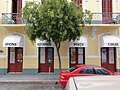
A street in Barrio Segundo at dusk, in the Ponce Historic Zone
Segundo, Ponce, Puerto Rico.svg
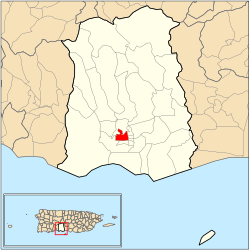
Location of barrio Segundo within the municipality of Ponce shown in red
Caribbean location map.svg
Red pog.svg
Segundo
Location of Puerto Rico
Coordinates: 18°00′52″N66°37′15″W / 18.014444°N 66.620809°W / 18.014444; -66.620809 [1]
Commonwealth Flag of Puerto Rico.svg  Puerto Rico
Municipality Bandera de Ponce, Puerto Rico.svg Ponce
Area
[1]
  Total0.53 sq mi (1.4 km2)
  Land0.53 sq mi (1.4 km2)
  Water0 sq mi (0 km2)
Elevation
[2]
85 ft (26 m)
Population
 (2010)
  Total7,213
  Density13,609.4/sq mi (5,254.6/km2)
 Source: 2010 Census
Time zone UTC−4 (AST)

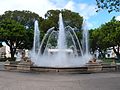
Segundo (Barrio Segundo) is one of the 31 barrios of the municipality of Ponce, Puerto Rico. Along with Primero, Tercero, Cuarto, Quinto, and Sexto, Segundo is one of the municipality's six core urban barrios. It was organized in 1878. [3] Barrio Segundo has 3 subbarrios: Baldority de Castro (or just "Baldorioty"), Clausells, [lower-alpha 1] and Reparada. [4]

Contents

Location

Segundo is an urban barrio located in the southern section of the municipality, within the Ponce city limits, and northwest of the traditional center of the city, Plaza Las Delicias.

Boundaries

Barrio Segundo is bounded on the North by Cinco Street, Pico Dulce Street, and Paseo de la Cruceta, on the South by Villa Street, on the West by Global Street, and on the East by Atocha, Plaza Munoz Rivera, and Plaza Degetau Streets. [5]

In terms of barrio-to-barrio boundaries, Segundo is bounded in the North by Portugués Urbano, in the South by Primero and Canas Urbano, in the West by Canas Urbano, and in the East by Sexto, Quinto, and Tercero.

The communities of Clausells, Ferran, and Tamarindo are located in Segundo.

25 de Enero Street, built for the families of Ponce firefighters in the nineteenth century, is located in Barrio Segundo Calle 25 de Enero.jpg
25 de Enero Street, built for the families of Ponce firefighters in the nineteenth century, is located in Barrio Segundo

Features and demographics

Segundo has 0.6 square miles (1.6 km2) of land area and no water area. In 2000, the population of Segundo was 11,321. In 2010, the population of Segundo was 7,213 persons, and it had a density of 13,609.4 persons per square mile. [6]

Historical population
CensusPop.Note
1900 5,866
1910 10,65781.7%
1920 13,88630.3%
1930 18,54433.5%
1940 26,02240.3%
1950 25,941−0.3%
1960 23,481−9.5%
1970 19,541−16.8%
1980 13,555−30.6%
1990 11,072−18.3%
2000 11,3212.2%
2010 7,213−36.3%
U.S. Decennial Census
1899 (shown as 1900) [7] 1910-1930 [8]
1930-1950 [9] 1960 [10] 1980-2000 [11] 2010 [12]

Notable landmarks

Segundo is home to a large number of Ponce's landmarks and historic sites. Plaza Las Delicias, 25 de Enero Street, and Paseo Atocha, are located there.

The NRHP-listed Parque de Bombas, Nuestra Señora de la Guadalupe Cathedral, Armstrong-Poventud Residence, Casa Wiechers-Villaronga (Architecture Museum), Panteón Nacional Román Baldorioty de Castro, Albergue Caritativo Tricoche, Casa Miguel C. Godreau, and Subira House are all located in Barrio Segundo.

See also

Notes

  1. According to Eduardo Questell Rodriguez, Pedro Clausells (ca. 1840 - ca. 1910) was a land surveyor from Ponce (See Eduardo Questell Rodriguez, Historia de la Comunidad Bélgica de Ponce, a partir de la Hacienda Muñiz y Otros datos. Ponce, Puerto Rico: Editores Mariana. 2018. pages 59-60.) He may have been a member of the family that owned Finca Clausells located in the subbarrio by that name (see Office of Head Start - Grantee Profile. Current Legally Approved Service Area: Municipality of Ponce, Puerto Rico. HERE).

Related Research Articles

<span class="mw-page-title-main">Plaza Las Delicias</span> Public square in Ponce, Puerto Rico

Plaza Las Delicias is the main plaza in the city of Ponce, Puerto Rico. The square is notable for its fountains and for the various monuments it contains. The historic Parque de Bombas and Ponce Cathedral buildings are located within the plaza, which actually consists of two squares: Plaza Muñoz Rivera on the north end, and Plaza Degetau on the southern end. The square is the center of the Ponce Historic Zone, and it is flanked by the historic Ponce City Hall to the south, the early 19th-century Teatro Fox Delicias to the north, the NRHP-listed Banco Crédito y Ahorro Ponceño and Banco de Ponce buildings to the east, and the Armstrong-Poventud Residence to the west. The square dates back to the early Spanish settlement in Ponce of 1670. It is the main tourist attraction of the city, receiving about a quarter of a million visitors per year.

<span class="mw-page-title-main">Olimpio Otero Vergés</span> Puerto Rican politician and businessman

Olimpio Otero Vergés was a merchant, attorney, composer, musical editor, and a civic leader in Ponce, Puerto Rico.

<span class="mw-page-title-main">Canas, Ponce, Puerto Rico</span> Barrio of Puerto Rico

Canas is one of the 31 barrios in the municipality of Ponce, Puerto Rico. Along with Anón, Coto Laurel, Guaraguao, Quebrada Limón, Real, San Patricio, and Marueño, and the coastal barrio of Capitanejo, Canas is one of the municipality's nine bordering barrios. It borders the municipality of Peñuelas. Along with Playa, Bucana, Vayas and Capitanejo, Canas is also one of Ponce's five coastal barrios. It was founded in 1831.

<span class="mw-page-title-main">San Antón</span> Barrio of Ponce, Puerto Rico

San Antón is one of the 31 barrios of the municipality of Ponce, Puerto Rico. Along with Canas Urbano, Machuelo Abajo, Magueyes Urbano, and Portugués Urbano, San Antón is one of the municipality's five originally rural barrios that are now also part of the urban zone of the city of Ponce. It is totally enclosed within the Ponce city limits. It was founded in 1818.

<span class="mw-page-title-main">Plaza Muñoz Rivera</span> Plaza in the city of Ponce, Puerto Rico

Plaza Muñoz Rivera, formally Plaza Luis Muñoz Rivera, is the smaller of the two plazas at Plaza Las Delicias in the city of Ponce, Puerto Rico. It is located on the north side of Plaza Las Delicias, north of the larger southern Plaza Degetau. The square is notable for its fountains and for the Luis Muñoz Rivera statue. The historic Parque de Bombas and Ponce Cathedral buildings are located immediately to the south of Plaza Muñoz Rivera. The square is at the center of the Ponce Historic Zone, and is flanked by the Armstrong-Poventud Residence to the west, the Teatro Fox Delicias to the north, and Catholic University of Puerto Rico School of Architecture to the east. The square dates back to the early Spanish settlement in Ponce of 1670. It is the main tourist attraction of the city, receiving about a quarter of a million visitors per year.

<span class="mw-page-title-main">Primero, Ponce, Puerto Rico</span> Barrio of Puerto Rico

Primero is one of the 31 barrios of the municipality of Ponce, Puerto Rico. Together with Segundo, Tercero, Cuarto, Quinto, and Sexto, Primero is one of the municipality's original six core urban barrios. It was founded in 1878.

<span class="mw-page-title-main">Tercero, Ponce, Puerto Rico</span> Barrio of Puerto Rico

Tercero is one of the 31 barrios of the municipality of Ponce, Puerto Rico. Together with Primero, Segundo, Cuarto, Quinto, and Sexto, Tercero is one of the municipality's six core urban barrios. It was organized in 1878.

<span class="mw-page-title-main">Cuarto, Ponce, Puerto Rico</span> Barrio of Puerto Rico

Cuarto is one of the 31 barrios of the municipality of Ponce, Puerto Rico. Together with Primero, Segundo, Tercero, Quinto, and Sexto, Cuarto is one of the municipality's six core urban barrios. It was created in 1878.

<span class="mw-page-title-main">Quinto, Ponce, Puerto Rico</span> Barrio of Puerto Rico

Quinto is one of the 31 barrios of the municipality of Ponce, Puerto Rico. Together with Primero, Segundo, Tercero, Cuarto, and Sexto, Quinto is one of the municipality's six original urban barrios. It was organized in 1878.

<span class="mw-page-title-main">Sexto, Ponce, Puerto Rico</span> Barrio of Puerto Rico

Sexto is one of the 31 barrios of the municipality of Ponce, Puerto Rico. Along with Primero, Segundo, Tercero, Cuarto, and Quinto, Sexto is one of the municipality's six core urban barrios. Barrio Sexto used to be called Barrio Cantera. It was organized in 1878.

<span class="mw-page-title-main">Canas Urbano</span> Barrio of Ponce, Puerto Rico

Canas Urbano is one of the 31 barrio of the municipality of Ponce, Puerto Rico. Along with Machuelo Abajo, Magueyes Urbano, Portugués Urbano, and San Antón, Canas Urbano is one of the municipality's five originally rural barrios that are now also part of the urban zone of the city of Ponce. The name of this barrio is of native indigenous origin. It was created in 1953.

<span class="mw-page-title-main">Portugués Urbano</span> Barrio of Ponce, Puerto Rico

Portugués Urbano is one of the 31 barrios in the municipality of Ponce, Puerto Rico. Along with Canas Urbano, Machuelo Abajo, Magueyes Urbano, and San Antón, Portugués Urbano is one of the municipality's five originally rural barrios that are now also part of the urban zone of the city of Ponce. It was founded in 1953.

<span class="mw-page-title-main">Magueyes Urbano</span> Barrio of Ponce, Puerto Rico

Magueyes Urbano is one of the 31 barrios in the municipality of Ponce, Puerto Rico. Along with Canas Urbano, Machuelo Abajo, Portugués Urbano, and San Antón, Magueyes Urbano is one of the municipality's five originally rural barrios that are now also part of the urban zone of the city of Ponce. The name of this barrio is of native Indian origin. It was created in 1953.

<span class="mw-page-title-main">Ponce Historic Zone</span> Historic area in Ponce, Puerto Rico

The Ponce Historic Zone is a historic district in downtown Ponce, Puerto Rico, consisting of buildings and structures with architecture that date to the late nineteenth and early twentieth centuries. The zone goes by various names, including Ponce Tradicional, Ponce Centro, Ponce Histórico, and Distrito Histórico.

<span class="mw-page-title-main">Teatro Fox Delicias</span> Historic building in the city of Ponce, Puerto Rico

Teatro Fox Delicias is a historic building in the city of Ponce, Puerto Rico. Inaugurated in 1931, it originally housed a movie house until 1980, from 1991 to 1998 it house a shopping mall, and stating in 2004 it housed a boutique hotel. Its architecture is Art Deco. Originally called Teatro Delicias, it was renamed Fox Delicias many years after its inauguration based on a contract with 20th Century Fox.

Francisco Parra Duperón (1827–1899) born in Mayagüez, Puerto Rico, was a lawyer and banker. He became a lawyer at a young age and moved from Mayagüez to Ponce, Puerto Rico, where he established his law practice. He was also one of the founders of the Banco Crédito y Ahorro Ponceño, and he was the bank's first president from 1895 until 1896. Teatro La Perla, was built in May 1864 under his initiative and that of Pedro Garriga.

The barrios of Puerto Rico are the primary legal divisions of the seventy-eight municipalities of Puerto Rico. Puerto Rico's 78 municipios are divided into geographical sections called barrios and, as of 2010, there were 902 of them. In the US Census a barrio sometimes includes a division called a comunidad or subbarrio. In Puerto Rico, barrios are composed of sectors. The types of sectors, (sectores) may vary, from normally sector to urbanización to reparto to barriada to residencial, among others.

Los Chinos de Ponce, formally King's Cream, is an Ice cream parlor located at Calle Marina 9322 in the city of Ponce, Puerto Rico, in front of the town square, Plaza Degetau, opposite the historic Parque de Bombas. Critics have called the site "a Puerto Rican institution" and its ice cream "the Caribbean's best." It has also been called "Puerto Rico's most famous ice cream stand." Another critic called it "[the reason] for which I'll always remember Ponce."

The following is a timeline of the history of the city of Ponce, Puerto Rico.

References

  1. 1 2 "US Gazetteer 2019". US Census. US Government.
  2. U.S. Geological Survey Geographic Names Information System: Segundo barrio
  3. Barrios de Ponce. Antepasados Esclavos.(From: Pedro Tomás de Córdoba. Memorias geográficas, históricas, económicas y estadísticas de la Isla de Puerto Rico.) Retrieved 28 November 2014.
  4. Puerto Rico:2010:population and housing unit counts.pdf 2010. U.S. Dept. of Commerce. Economics and Statistics Administration. U.S. Census Bureau. Page 74. Accessed 12 February 2019.
  5. General Purpose Population Data, Census 2000. Unidad de Sistemas de Información Geográfica, Área de Tecnología de Información Gubernamental, Oficina de Gerencia y Presupuesto. Gobierno de Puerto Rico. Archived 12 August 2010 at the Wayback Machine Retrieved February 17, 2010.
  6. Puerto Rico:2010:population and housing unit counts.pdf (PDF). U.S. Dept. of Commerce, Economics and Statistics Administration, U.S. Census Bureau. 2010.
  7. "Report of the Census of Porto Rico 1899". War Department Office Director Census of Porto Rico. Archived from the original on 16 July 2017. Retrieved 21 September 2017.
  8. "Table 3-Population of Municipalities: 1930 1920 and 1910" (PDF). United States Census Bureau. Archived (PDF) from the original on 17 August 2017. Retrieved 21 September 2017.
  9. "Table 4-Area and Population of Municipalities Urban and Rural: 1930 to 1950" (PDF). United States Census Bureau. Archived (PDF) from the original on 30 August 2015. Retrieved 21 September 2014.
  10. Census of Population, 1960: Number of Inhabitants, General Population Characteristics, General Social and Economic Characteristics, and Detailed Characteristics. Characteristics of the population. U.S. Bureau of the Census. 1963. pp. 97–101. Retrieved 10 June 2023.
  11. "Table 2 Population and Housing Units: 1960 to 2000" (PDF). United States Census Bureau. Archived (PDF) from the original on 24 July 2017. Retrieved 21 September 2017.
  12. Puerto Rico: 2010 Population and Housing Unit Counts.pdf (PDF). U.S. Dept. of Commerce Economics and Statistics Administration U.S. Census Bureau. 2010. Archived (PDF) from the original on 20 February 2017. Retrieved 2 August 2019.