Tercero, Ponce, Puerto Rico

Last updated

Tercero
Calle Tipica en el Barrio Tercero (Calle Isabel) en Ponce, PR (DSC01696).jpg
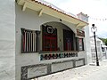
Typical street in Barrio Tercero (showing Calle Isabel, looking west)
Tercero, Ponce, Puerto Rico.svg
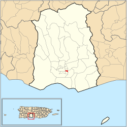
Location of barrio Tercero within the municipality of Ponce shown in red
Caribbean location map.svg
Red pog.svg
Tercero
Location of Puerto Rico
Coordinates: 18°00′40″N66°36′36″W / 18.010985°N 66.61012°W / 18.010985; -66.61012 [1]
Commonwealth Flag of Puerto Rico.svg  Puerto Rico
Municipality Bandera de Ponce, Puerto Rico.svg Ponce
Area
[1]
  Total0.08 sq mi (0.2 km2)
  Land0.08 sq mi (0.2 km2)
  Water0 sq mi (0 km2)
Elevation
[2]
52 ft (16 m)
Population
 (2010)
  Total668
  Density8,350/sq mi (3,220/km2)
 Source: 2010 Census
Time zone UTC−4 (AST)

Tercero (Barrio Tercero) is one of the 31 barrios of the municipality of Ponce, Puerto Rico. Together with Primero, Segundo, Cuarto, Quinto, and Sexto, Tercero is one of the municipality's six core urban barrios. It was organized in 1878. [3]

Contents

Location

Tercero is an urban barrio located in the southern section of the municipality, within the Ponce city limits, and east of the traditional center of the city, Plaza Las Delicias.

Boundaries

External audio
Nuvola apps arts.svg You may see a video of Barrio Tercero HERE

Barrio Tercero is bounded on the North by Isabel Street, on the South by Comercio/Francisco Parra Duperón Street, on the West by Plaza Degetau and Plaza Munoz Rivera Streets, and on the East by Rio Portugues. [4]

In terms of barrio-to-barrio boundaries, Tercero is bounded in the North by Barrio Quinto, in the South by Cuarto, in the West by Segundo, and in the East by Machuelo Abajo and San Antón.

Features and demographics

In 2000, Tercero had 0.1 square miles (260,000 m2) of land area and no water area. The population of Tercero was 773. The population density in Tercero was 10,134 persons per square mile. [5]

In 2010, it had 0.08 square miles (210,000 m2) of land area and no water area. Its population was 668 persons, and it had a density of 8,350 persons per square mile. [6]

Historical population
CensusPop.Note
1900 1,808
1910 1,563−13.6%
1920 1,362−12.9%
1930 1,138−16.4%
1940 1,1561.6%
1950 1,73349.9%
1960 1,573−9.2%
1970 1,338−14.9%
1980 1,096−18.1%
1990 970−11.5%
2000 773−20.3%
2010 668−13.6%
U.S. Decennial Census
1899 (shown as 1900) [7] 1910-1930 [8]
1930-1950 [9] 1960 [10] 1980-2000 [11] 2010 [12]

Notable landmarks

Tercero is home to many city landmarks. [13] The Antonio Arias Ventura promenade, Ponce History Museum, Tricentennial Park, Teatro La Perla, and the Museum of Puerto Rican Music are all located in Barrio Tercero. Also, the NRHP-listed Banco de Ponce, Ponce High School, Banco Crédito y Ahorro Ponceño, and Salazar-Candal House are found in Barrio Tercero as well.

See also

Related Research Articles

<span class="mw-page-title-main">Plaza Las Delicias</span> Public square in Ponce, Puerto Rico

Plaza Las Delicias is the main plaza in the city of Ponce, Puerto Rico. The square is notable for its fountains and for the various monuments it contains. The historic Parque de Bombas and Ponce Cathedral buildings are located within the plaza, which actually consists of two squares: Plaza Muñoz Rivera on the north end, and Plaza Degetau on the southern end. The square is the center of the Ponce Historic Zone, and it is flanked by the historic Ponce City Hall to the south, the early 19th-century Teatro Fox Delicias to the north, the NRHP-listed Banco Crédito y Ahorro Ponceño and Banco de Ponce buildings to the east, and the Armstrong-Poventud Residence to the west. The square dates back to the early Spanish settlement in Ponce of 1670. It is the main tourist attraction of the city, receiving about a quarter of a million visitors per year.

<span class="mw-page-title-main">Ponce City Hall</span> Historic government building in Ponce, Puerto Rico

The Ponce City Hall is a historic city hall in Ponce, Puerto Rico. It is located it the center of the city, on Calle Degetau, across from Plaza Degetau in the Ponce Historic Zone. The building serves as the seat of the executive branch of government of the Autonomous Municipality of Ponce, including the office of the Mayor of Ponce. Built in 1840, it is the oldest colonial building in the city. The building was listed on the U.S. National Register of Historic Places in 1986 as Casa Alcaldía de Ponce-City Hall.

<span class="mw-page-title-main">Playa, Ponce, Puerto Rico</span> Barrio of Puerto Rico

Barrio Playa, also known as Playa de Ponce, Ponce Playa, or La Playa, is one of the thirty-one barrios that comprise the municipality of Ponce, Puerto Rico. Along with Bucaná, Canas, Vayas, and Capitanejo, Playa is one of the municipality's five coastal barrios. Barrio Playa also incorporates several islands, the largest of which is Caja de Muertos. It was founded in 1831.

<span class="mw-page-title-main">Canas, Ponce, Puerto Rico</span> Barrio of Puerto Rico

Canas is one of the 31 barrios in the municipality of Ponce, Puerto Rico. Along with Anón, Coto Laurel, Guaraguao, Quebrada Limón, Real, San Patricio, and Marueño, and the coastal barrio of Capitanejo, Canas is one of the municipality's nine bordering barrios. It borders the municipality of Peñuelas. Along with Playa, Bucana, Vayas and Capitanejo, Canas is also one of Ponce's five coastal barrios. It was founded in 1831.

<span class="mw-page-title-main">Magueyes, Ponce, Puerto Rico</span> Barrio of Puerto Rico

Magueyes is one of the 31 barrios of the municipality of Ponce, Puerto Rico. Together with Cerrillos, Machuelo Arriba, Maragüez, Montes Llanos, Portugués, Sabanetas, and Tibes, Magueyes is one of the municipality's eight interior barrios. The name of this barrio is of native Indian origin. It was created in 1831.

<span class="mw-page-title-main">Coto Laurel</span> Barrio of Ponce, Puerto Rico

Coto Laurel is one of the 31 barrios of the municipality of Ponce, Puerto Rico. Along with Anón, Marueño, Guaraguao, Quebrada Limon, Real, and San Patricio, and the coastal barrios of Canas and Capitanejo, Coto Laurel is one of the municipality's nine bordering barrios. It borders the municipality of Juana Diaz. It was founded in 1831.

<span class="mw-page-title-main">Maragüez</span> Barrio of Ponce, Puerto Rico

Maragüez is one of the 31 barrios of the municipality of Ponce, Puerto Rico. Along with Magueyes, Tibes, Portugués, Montes Llanos, Machuelo Arriba, Sabanetas, and Cerrillos, Maragüez is one of the municipality's eight rural interior barrios. The name of this barrio is of native Indian origin. It was created in 1878.

<span class="mw-page-title-main">Portugués (Ponce)</span> Barrio of Ponce, Puerto Rico

Portugués Rural or, more commonly, simply Portugués, is one of the 31 barrios in the municipality of Ponce, Puerto Rico. Along with Magueyes, Tibes, Montes Llanos, Maragüez, Machuelo Arriba, Sabanetas, and Cerrillos, Portugués is one of the municipality's eight rural interior barrios. It was founded in 1831.

<span class="mw-page-title-main">Vayas</span> Barrio of Ponce, Puerto Rico

Vayas is one of the 31 barrios of the municipality of Ponce, Puerto Rico. Along with Playa, Bucana, Canas and Capitanejo, Vayas is also one of Ponce's five coastal barrios. Together with Capitanejo, Vayas is also one of two rural coastal barrios in the municipality. It was organized in 1831, at which time it was divided into Vayas Norte and Vayas Sur; in 1878 the two were subsequently merged into today's Vayas.

<span class="mw-page-title-main">Bucaná</span> Barrio of Ponce, Puerto Rico

Bucaná is one of the 31 barrios of the municipality of Ponce, Puerto Rico. Together with Canas, Playa, Vayas, and Capitanejo, Bucaná is one of the municipality's five coastal barrios. The name of this barrio is of native Indian origin. It was founded in 1831.

<span class="mw-page-title-main">Quebrada Limón</span> Barrio of Ponce, Puerto Rico

Quebrada Limón is one of the 31 barrios of the municipality of Ponce, Puerto Rico. Along with Anón, Coto Laurel, Guaraguao, Marueño, Real, and San Patricio, and the coastal barrios of Canas and Capitanejo, Quebrada Limón is one of the municipality's nine bordering barrios. It borders the municipality of Peñuelas. It was founded in 1878.

<span class="mw-page-title-main">Sabanetas, Ponce, Puerto Rico</span> Barrio of Puerto Rico

Sabanetas is one of the 31 barrios of the municipality of Ponce, Puerto Rico. Along with Magueyes, Tibes, Portugués, Montes Llanos, Machuelo Arriba, Maragüez, and Cerrillos, Sabanetas is one of the municipality's eight rural interior barrios. The name of this barrio is of native Indian origin. It was founded in 1831.

<span class="mw-page-title-main">Real, Ponce, Puerto Rico</span> Barrio of Puerto Rico

Real is one of the 31 barrios of the municipality of Ponce, Puerto Rico. Along with Anón, Coto Laurel, Guaraguao, Quebrada Limón, Marueño, and San Patricio, and the coastal barrios of Canas and Capitanejo, Real is one of the municipality's nine bordering barrios. It borders the municipality of Juana Diaz. It was founded in 1878.

<span class="mw-page-title-main">Primero, Ponce, Puerto Rico</span> Barrio of Puerto Rico

Primero is one of the 31 barrios of the municipality of Ponce, Puerto Rico. Together with Segundo, Tercero, Cuarto, Quinto, and Sexto, Primero is one of the municipality's original six core urban barrios. It was founded in 1878.

<span class="mw-page-title-main">Cuarto, Ponce, Puerto Rico</span> Barrio of Puerto Rico

Cuarto is one of the 31 barrios of the municipality of Ponce, Puerto Rico. Together with Primero, Segundo, Tercero, Quinto, and Sexto, Cuarto is one of the municipality's six core urban barrios. It was created in 1878.

<span class="mw-page-title-main">Segundo, Ponce, Puerto Rico</span> Barrio of Puerto Rico

Segundo is one of the 31 barrios of the municipality of Ponce, Puerto Rico. Along with Primero, Tercero, Cuarto, Quinto, and Sexto, Segundo is one of the municipality's six core urban barrios. It was organized in 1878. Barrio Segundo has 3 subbarrios: Baldority de Castro, Clausells, and Reparada.

<span class="mw-page-title-main">Quinto, Ponce, Puerto Rico</span> Barrio of Puerto Rico

Quinto is one of the 31 barrios of the municipality of Ponce, Puerto Rico. Together with Primero, Segundo, Tercero, Cuarto, and Sexto, Quinto is one of the municipality's six original urban barrios. It was organized in 1878.

<span class="mw-page-title-main">Sexto, Ponce, Puerto Rico</span> Barrio of Puerto Rico

Sexto is one of the 31 barrios of the municipality of Ponce, Puerto Rico. Along with Primero, Segundo, Tercero, Cuarto, and Quinto, Sexto is one of the municipality's six core urban barrios. Barrio Sexto used to be called Barrio Cantera. It was organized in 1878.

<span class="mw-page-title-main">Canas Urbano</span> Barrio of Ponce, Puerto Rico

Canas Urbano is one of the 31 barrio of the municipality of Ponce, Puerto Rico. Along with Machuelo Abajo, Magueyes Urbano, Portugués Urbano, and San Antón, Canas Urbano is one of the municipality's five originally rural barrios that are now also part of the urban zone of the city of Ponce. The name of this barrio is of native indigenous origin. It was created in 1953.

<span class="mw-page-title-main">Magueyes Urbano</span> Barrio of Ponce, Puerto Rico

Magueyes Urbano is one of the 31 barrios in the municipality of Ponce, Puerto Rico. Along with Canas Urbano, Machuelo Abajo, Portugués Urbano, and San Antón, Magueyes Urbano is one of the municipality's five originally rural barrios that are now also part of the urban zone of the city of Ponce. The name of this barrio is of native Indian origin. It was created in 1953.

References

  1. 1 2 "US Gazetteer 2019". US Census. US Government.
  2. U.S. Geological Survey Geographic Names Information System: Tercero barrio
  3. Barrios de Ponce. Archived 30 September 2015 at the Wayback Machine Antepasados Esclavos.(From: Pedro Tomás de Córdoba. Memorias geográficas, históricas, económicas y estadísticas de la Isla de Puerto Rico.) Retrieved 28 November 2014.
  4. General Purpose Population Data, Census 2000. Unidad de Sistemas de Información Geográfica, Área de Tecnología de Información Gubernamental, Oficina de Gerencia y Presupuesto. Gobierno de Puerto Rico. Archived 12 August 2010 at the Wayback Machine Retrieved February 17, 2010.
  5. City Melt Retrieved, February 17, 2010.
  6. Puerto Rico:2010:population and housing unit counts.pdf (PDF). U.S. Dept. of Commerce, Economics and Statistics Administration, U.S. Census Bureau. 2010.
  7. "Report of the Census of Porto Rico 1899". War Department Office Director Census of Porto Rico. Archived from the original on 16 July 2017. Retrieved 21 September 2017.
  8. "Table 3-Population of Municipalities: 1930 1920 and 1910" (PDF). United States Census Bureau. Archived (PDF) from the original on 17 August 2017. Retrieved 21 September 2017.
  9. "Table 4-Area and Population of Municipalities Urban and Rural: 1930 to 1950" (PDF). United States Census Bureau. Archived (PDF) from the original on 30 August 2015. Retrieved 21 September 2014.
  10. Census of Population, 1960: Number of Inhabitants, General Population Characteristics, General Social and Economic Characteristics, and Detailed Characteristics. Characteristics of the population. U.S. Bureau of the Census. 1963. pp. 97–101. Retrieved 10 June 2023.
  11. "Table 2 Population and Housing Units: 1960 to 2000" (PDF). United States Census Bureau. Archived (PDF) from the original on 24 July 2017. Retrieved 21 September 2017.
  12. Puerto Rico: 2010 Population and Housing Unit Counts.pdf (PDF). U.S. Dept. of Commerce Economics and Statistics Administration U.S. Census Bureau. 2010. Archived (PDF) from the original on 20 February 2017. Retrieved 2 August 2019.
  13. Plan de Area de los Centros Urbanos de Ponce: Map 106A. [ permanent dead link ] Office of Territorial Ordering. Autonomous Municipality of Ponce. Ponce, Puerto Rico. Retrieved 5 August 2011.