Part of a series on |
Tourism in Puerto Rico |
---|
Tourism Regions |
Beaches |
Caves |
Cays and islets |
Convention centers |
Culture |
Islands |
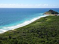
The municipality of Ponce, Puerto Rico, has 40 [1] beaches including 28 on the mainland and 12 in its offshore islands, primarily at the deserted island of Caja de Muertos. [1] This list of beaches in Ponce, Puerto Rico, consists of some of the most popular beaches in the municipality of Ponce, Puerto Rico. Only natural salt-water beaches are listed.
All beaches in Ponce are public beaches and accessible to the general public at large, except for the beach at the Club Nautico de Ponce, which is accessible to members of that club only. Some public beaches are off-limits to the general public due to preservation or protection efforts. This is the case, for example, of beaches protected under the law by the Puerto Rico Department of Natural and Environmental Resources. Playa Larga beach, in Caja de Muertos, falls in this latter category. None of the beaches in Ponce are among Puerto Rico's 10 most dangerous beaches in terms of number of drownings. [2]
Among beaches in Ponce, a few of the most popular [3] are El Tuque Beach in the El Tuque sector of Barrio Canas, near highway PR-2, west of the city; La Guancha Beach at the La Guancha complex south of the city; and four beaches in Caja de Muertos: Playa Pelícano beach, Playa Larga beach, Playa Carrucho beach, and Playa Blanca beach. [4] Playa Pelicano beach was the first beach in Puerto Rico - and the entire Caribbean [5] - to attain Blue Flag Beach status. [6] [7] It is also the only beach in the world part of a nature reserve that holds this recognition. [8] Most beaches in Ponce are small secluded beaches known mostly to local people and accessed by dirt roads. They are part of a coastal stretch in southwestern Puerto Rico "filled with isolated sandy coves and virgin white beaches accessible only by dirt roads that only the locals seem to know about." [9] While there are several family-oriented beaches, like La Guancha and El Tuque, there are also many beaches ideal for sunbathing and relaxation as well as many spots for just being alone. [9] Some beaches are more apt for some types of activities, such as scuba diving, than other beaches. Beaches in Caja de Muertos can be reached via private boat or, during the weekends, via a daily ferry that leaves early in the mornings (reservations are required) from the La Guancha Boardwalk in Barrio Playa. [3]
Ponce beaches are the result of mineral aggregate found in them, and this is, in turn, the result of silt carried by the Ponce river system from the mountains of Cordillera Central. [10] In this manner the composition of its beaches are determined by the geological regions through which the nearby rivers flow. Beaches west of Ponce (El Tuque, Las Salinas, Matilde, etc.) exhibit sand that is mostly white, resulting from its calcareous content, and primarily composed of coral fragments and marine shells. Beaches east of Ponce (La Guancha, Club Nautico, Hilton, Cabuyon, Vayas, etc.) exhibit sand that is mostly dark sand with magnetite, and composed of fragments of volcanic rock, quartz, and calcareous detritus. [11] [12] [13] [14] Also, the sand at mainland Ponce beaches tends to be generally dark [15] while in the offshore Ponce islands sand is white. [16]
External audio | |
---|---|
You may see Ponce's Playa Pelicano at Caja de Muertos HERE |
No. | Beach Name | Length (m) | Barrio | Sector | Coordinates | Activities and Services | Notes | Image |
---|---|---|---|---|---|---|---|---|
1 | El Tuque; [17] a.k.a., Balneario El Tuque [18] | 1100 [12] | Canas | El Tuque, PR-2, at km 200.1 [19] | 17°58′21″N066°40′43″W / 17.97250°N 66.67861°W | |||
2 | Punta Salinera [21] | unknown | Canas [22] | Southwest of Laguna Las Salinas on PR-2, km 200.2 | 17°58′1.67″N066°40′18.37″W / 17.9671306°N 66.6717694°W | |||
3 | Las Salinas [12] | unknown | Canas [12] | South of Laguna Las Salinas [23] on PR-2, km 200.2 | 17°58′07″N066°40′00″W / 17.96861°N 66.66667°W | [24] | ||
4 | Cañas [12] | 1100 [12] | Canas | Between Punta Cucharas and the jetty just west of the Ponce water treatment plant. [25] Accessed from PR-2 & Ave. Punto Oro, south on the asphalt, gravel, and (then) dirt road to the end. | 17°58′42″N066°39′07″W / 17.97833°N 66.65194°W | [26] | ||
5 | Matilde [17] [note 1] | unknown | Canas | South of the Ponce water treatment plant; just west of Río Matilde. [27] [28] Accessed from PR-2 and PR-9, heading south, following the road leading to the Ponce water treatment plant. | 17°58′51″N066°38′28″W / 17.98083°N 66.64111°W | [29] | ||
6 | Chencha; [30] a.k.a., "El Tubo" [31] | 500 [30] | Playa | Between Río Matilde eastward to the breakwater at Ocean View Restaurant (Dorado St.) [31] Accessed from PR-585, then Ave. Los Meros to the end. | 17°58′55″N066°38′11″W / 17.98194°N 66.63639°W | |||
7 | Los Meros [30] | 500 [30] | Playa | Between the breakwater at Ocean View Restaurant (Dorado St) and the Villa Pesquera fishing village piers (former mouth of Río Portugués) [30] Accessed from PR-585, then Ave. Los Meros, then Ocean View Restaurant. | 17°58′57″N066°37′44″W / 17.98250°N 66.62889°W | [32] | ||
8 | Playa de Ponce [33] [note 2] | unknown | Playa | Between the Villa Pesquera fishing piers and the Ave. Hostos Final pier. At the southernmost tip of PR-585 [12] [34] | 17°58′51″N066°37′23″W / 17.98083°N 66.62306°W | [35] | ||
9 | El Malecón [1] | unknown | Playa | At Parque Pasivo Enrique Gonzalez on Calle Bonaire, [36] two blocks south of the southernmost tip of Avenida Hostos (PR-123) in barrio Playa de Ponce | 17°58′45″N066°37′11″W / 17.97917°N 66.61972°W | Also the Finish site of Cruce a Nado Internacional [38] | [1] | |
10 | Club Náutico de Ponce | unknown | Playa | Isla de Gatas, within the Club Náutico de Ponce property, across from La Guancha Boardwalk, accessed via PR-12 | 17°57′49″N066°37′10″W / 17.96361°N 66.61944°W | This beach is within the area of Club Nautico de Ponce, a private club | ||
11 | La Guancha; [39] a.k.a. Playa Carenero [12] | 850 [12] | Playa [40] | La Guancha Recreational and Cultural Complex, at the southernmost tip of PR-12 (Avenida Santiago de los Caballeros) | 17°57′50″N066°36′43″W / 17.96389°N 66.61194°W | |||
12 | Playa del Hilton [43] | unknown | Playa | Hotel Ponce Hilton, west of Río Bucaná, accessible through Hilton Ponce Golf and Casino Resort, PR-12 South to Avenida Caribe | 17°58′10″N066°36′08″W / 17.96944°N 66.60222°W | [44] | ||
13 | Punta Cabuyón; [12] a.k.a., Playa Punta Cabullones. [45] | 325 [12] | Vayas | Just west of Punta de Cabullones, [46] accessed from Barrio Bucana by way of Santa Cruz community (becomes a dirt road). | 17°58′15″N066°35′38″W / 17.97083°N 66.59389°W | A nature reserve since 31 December 2016. [47] | ||
14 | Vayas [12] | 2200 [12] | Vayas | Area of Quinta Esperanza, across from Cayo Desgraciado, [46] accessed from PR-1 to Calle La Esperanza to the end (becomes a dirt road). | 17°58′1″N066°34′08″W / 17.96694°N 66.56889°W | |||
No. | Beach Name | Length (m) | Barrio | Sector | Coordinates | Activities and Services | Notes | Image |
---|---|---|---|---|---|---|---|---|
Beaches at Isla de Ratones | ||||||||
15 | Isla de Ratones [48] | unknown | Canas | At Isla de Ratones, accessed by kayak [48] from Reserva Natural Punta Cucharas or by boat via boat ramp at marina just west of Punta Cucharas sector on PR-2 [23] | 17°57′08″N066°40′51″W / 17.95222°N 66.68083°W | |||
Beaches at Isla Cardona | ||||||||
16 | Isla Cardona [49] | unknown | Playa | At Isla Cardona, accessed by kayak or boat | 17°57′28″N066°38′11″W / 17.95778°N 66.63639°W | Also the Start site of Cruce a Nado Internacional [38] | [49] | |
Beaches at Caja de Muertos | ||||||||
17 | Pelícano [50] | 300 [12] | Playa | Caja de Muertos; located on the western (docking) side of the island, between the boat dock and Cerro Morrillo, [51] [52] accessed by ferry from La Guancha Boardwalk [3] | 17°53′08″N066°31′41″W / 17.88556°N 66.52806°W | ; [20] ; [20] ; [20] ; [53] [18] ; [53] [18] ; [53] [53] | [6] [16] | |
18 | Guardia Costanera [56] | unknown | Playa | Caja de Muertos; located on the northwest side of the island (facing the city of Ponce), northwest of the Caja de Muertos Light, [51] [52] accessed by ferry from La Guancha Boardwalk [3] | 17°53′45″N066°40′43″W / 17.89583°N 66.67861°W | |||
19 | Blanca [50] | unknown | Playa | Caja de Muertos; located on the northwest side of the island (facing the city of Ponce), northwest of the Caja de Muertos Light., [51] [52] accessed by ferry from La Guancha Boardwalk [3] | 17°53′56″N066°31′12″W / 17.89889°N 66.52000°W | |||
20 | Carrucho [50] [16] a.k.a., Playa Chica [50] [52] | unknown | Playa | Caja de Muertos; located on Punta Carrucho, at the northeast [59] end the island, facing the Puerto Rico mainland, [50] [60] [52] accessed by ferry from La Guancha Boardwalk [3] | 17°54′09″N066°30′46″W / 17.90250°N 66.51278°W | |||
21 | Ensenadita [50] a.k.a., Playa Pocitas [50] | unknown | Playa | Caja de Muertos, located on the southeastern side of the island, facing the open Caribbean Sea. Accessed by ferry from La Guancha Boardwalk [3] | 17°53′38″N066°30′54″W / 17.89389°N 66.51500°W | |||
22 | Larga [50] [52] | unknown | Playa | Caja de Muertos, located on the south-southeast side of the island, [51] accessed by ferry from La Guancha Boardwalk [3] | 17°53′08″N066°31′38″W / 17.88556°N 66.52722°W | Vereda Submarina; offshore-based snorkeling and scuba allowed. [18] [50] A protected beach (i.e., no foot traffic) located on the southeastern side of the island between Cerro Morrillo and Caja de Muertos Light (the side facing the open Caribbean Sea). | ||
Ponce is a city and a municipality on the southern coast of Puerto Rico. The most populated city outside the San Juan metropolitan area, was founded on August 12, 1692 and is named after Juan Ponce de León y Loayza, the great-grandson of Spanish conquistador Juan Ponce de León. Ponce is often referred to as La Perla del Sur, La Ciudad Señorial, and La Ciudad de las Quenepas.
Caja de Muertos is an uninhabited island off the southern coast of Puerto Rico, in the municipality of Ponce. The island and its surrounding waters are protected by the Caja de Muertos Nature Reserve, because of its native turtle traffic and ecological value of its dry forests and reefs. Hikers and beachgoers are often seen in the island, which can be reached by ferry from the La Guancha Boardwalk sector of Ponce Playa. Together with Cardona, Ratones, Morrillito, Isla del Frio, Gatas, and Isla de Jueyes, Caja de Muertos is one of seven islands ascribed to the municipality of Ponce.
Luis Antonio ("Wito") Morales Crespo was a Puerto Rican politician and Mayor of Ponce, Puerto Rico, from 1973 to 1976. He was also Senator for the District of Ponce from 1977 to 1980 and president of the Ponce Municipal Assembly from 1989 to 2004 He is recognized as a politician, sportsman, and sports broadcaster.
Paseo Tablado La Guancha is a boardwalk in the La Guancha sector of the Playa barrio in the city of Ponce, Puerto Rico, facing the Caribbean Sea. It was built under the mayoral administration of Rafael Cordero Santiago, Mayor of Ponce from 1989 to 2004, at a cost of 2.6 million dollars, and inaugurated on 23 June 1998. It receives over 750,000 visitors a year. In September 2017 the boardwalk was damaged by Hurricane Maria and the area closest to the water was fenced off and off-limits to the public, but the rest of the facilities continued to operate uninterrupted. In January 2020, however, while still fenced off from the 2017 hurricane damage, the boardwalk—together with its adjoining recreational complex—closed when the area suffered severe damage from the 2020 Puerto Rico earthquakes and, as of 17 June 2020, it remained closed. By late 2020 arrangements were made for the merchants that operated from waterfront kiosks to reopen their businesses out of provisional facilities at a temporary location away from the waterfront while reconstruction of the waterfront area takes place.
El Tuque is a beach and family recreational and tourist complex in the Punta Cucharas sector of Barrio Canas in Ponce, Puerto Rico. It was designed in the early 1960s by Luis Flores, an architect from Cayey, Puerto Rico. It is located on PR-2, Km 220.1, in the El Tuque sector of Barrio Canas in Ponce. The sector of El Tuque is considered Puerto Rico's largest populated sector. The beach opened on 17 July 1965.
Barrio Playa, also known as Playa de Ponce, Ponce Playa, or La Playa, is one of the thirty-one barrios that comprise the municipality of Ponce, Puerto Rico. Along with Bucaná, Canas, Vayas, and Capitanejo, Playa is one of the municipality's five coastal barrios. Barrio Playa also incorporates several islands, the largest of which is Caja de Muertos. It was founded in 1831.
Porta Caribe is a tourism region in southern Puerto Rico. It was established in 2003 by the Puerto Rico Tourism Company, an agency of the Government of Puerto Rico. When created in 2003 it consisted of 14 municipalities in the south central zone. With the creation of the neighboring Porta Cordillera zone in July 2012, the municipalities of Adjuntas and Jayuya were transferred to the newly created Porta Cordillera zone and Porta Caribe became a 12-municipality tourism region. The name Porta Caribe translates to "Doorway to the Caribbean." Its executive director is Maritza W. Ruiz Cabán.
Morrillito is a small uninhabited island off the southern coast of Puerto Rico. The island is protected by the Reserva Natural Caja de Muertos natural reserve because of its native turtle traffic. Together with Caja de Muertos, Gatas, Ratones, Cardona, Isla del Frio, and Isla de Jueyes, Morrillito is one of seven islands ascribed to the municipality of Ponce.
Gatas or, more commonly, Isla de Gatas, is a small island in barrio Playa in the municipality of Ponce in southern Puerto Rico. A tied island since the 1950s connected to the Puerto Rico mainland via a tombolo, Isla de Gatas is home to Club Náutico de Ponce, a private sports complex. It is located south of La Guancha and the Port of Ponce. Together with Caja de Muertos, Morrillito, Ratones, Cardona, Isla del Frio, and Isla de Jueyes, Gatas is one of seven islands in the municipality of Ponce.
Isla Cardona, also known as Sor Isolina Ferré Island, is a small, uninhabited island located 1.30 nautical miles south of the mainland Puerto Rican shore across from Barrio Playa, on the west side of the entrance to the harbor of Ponce, Puerto Rico. The small island is considered part of barrio Playa. It is home to the 1889 Cardona Island Light, which is listed in the U.S. National Register of Historic Places. Together with Caja de Muertos, Gatas, Morrillito, Ratones, Isla del Frio, and Isla de Jueyes, Cardona is one of seven islands ascribed to the municipality of Ponce. The island gained notoriety in 2010 when the Puerto Rican Bird Society made it a target for the eradication of the black rat.
SITRAS, officially, Sistema Integrado de TRAnsportación del Sur, is the mass transit system in the city of Ponce, Puerto Rico. The service was inaugurated on 14 February 2012.
The following is a timeline of the history of the city of Ponce, Puerto Rico.
The Complejo Recreativo y Cultural La Guancha is a recreational complex in barrio Playa in Ponce, Puerto Rico, with family recreational and cultural facilities that opened on 23 June 1998. The highlight of the complex is the Paseo Tablado La Guancha, which is flanked by a beach, an observation tower, an amphitheater, and 24 open-air kiosks. It was developed during the administration of Mayor Rafael Cordero Santiago. In October 2017, after Hurricane Maria, it closed to the public to undergo repairs but, as of January 2020, when the area suffered severe damage due to the 2020 Puerto Rico earthquakes, no repairs had been made and, as of 17 June 2020, it remained closed. By late 2020 arrangements were made for the merchants that operated from waterfront kiosks to reopen their businesses out of provisional facilities at a temporary location away from the waterfront while reconstruction of the waterfront area takes place.
Bahía de Ponce is a bay in Barrio Playa, Ponce, Puerto Rico. The Bay is home to the most important commercial harbor on the Puerto Rico south coast and the second largest in Puerto Rico. The Cardona Island Light is located on the Bay to mark the way into the Bay from the nearby Caja de Muertos Light.
Fuerte de San José, also known as Fuerte de la Playa de Ponce, was an 18th-19th-century Spanish fortress located in Barrio Playa in the municipality of Ponce, Puerto Rico. It was part of a three-fort system design to defend the Port of Ponce, the Barrio Playa seaport village and the City of Ponce from seaborne attacks. However, only two of the three fortifications materialized, with Fuerte San José being the largest and most complete. The fort was in operation 125 years, from 1760 to 20 March 1885, and was demolished in 1907 by order of the Puerto Rico Legislature to make room for the growing civilian population of Barrio Playa. Fuerte de San José has been compared to Fortín de San Gerónimo in San Juan, in terms of design, purpose and size.
Caja de Muertos Nature Reserve is a nature reserve in southern Puerto Rico consisting of the islands of Caja de Muertos, Cayo Morrillito, Cayo Berbería, and their surrounding reefs and waters in the Caribbean Sea. This nature reserve was founded on January 2, 1980, by the Puerto Rico Planning Board as recommended by the Puerto Rico Department of Natural and Environmental Resources with the purpose of preserving the subtropical dry forest ecosystems found within these islands, some important sea turtle nesting sites, and the marine habitats found on their surrounding reefs and waters.