Isla Culebra is an island, town and municipality of Puerto Rico, and together with Vieques, it is geographically part of the Spanish Virgin Islands. It is located approximately 17 miles (27 km) east of the Puerto Rican mainland, 12 miles (19 km) west of St. Thomas and 9 miles (14 km) north of Vieques. Culebra is spread over 5 barrios and Culebra Pueblo (Dewey), the main town and the administrative center of the island. Residents of the island are known as culebrenses. With a population of 1,792 as of the 2020 Census, it is Puerto Rico's least populous municipality.

The following is an alphabetical list of articles related to the Commonwealth of Puerto Rico.
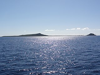
Caja de Muertos is an uninhabited island off the southern coast of Puerto Rico, in the municipality of Ponce. The island and its surrounding waters are protected by the Caja de Muertos Nature Reserve, because of its native turtle traffic and ecological value of its dry forests and reefs. Hikers and beachgoers are often seen in the island, which can be reached by ferry from the La Guancha Boardwalk sector of Ponce Playa. Together with Cardona, Ratones, Morrillito, Isla del Frio, Gatas, and Isla de Jueyes, Caja de Muertos is one of seven islands ascribed to the municipality of Ponce.

The Spanish Virgin Islands, formerly called the Passage Islands, commonly known as the Puerto Rican Virgin Islands, consist of the islands of Vieques and Culebra, located between the main island of Puerto Rico and the U.S. Virgin Islands in the northeastern Caribbean. Located between the Greater and Lesser Antilles, the islands are administratively part of the archipelago of Puerto Rico, and geographically part of the archipelago of the Virgin Islands of the Leeward Islands in the Lesser Antilles.

Canas is one of the 31 barrios in the municipality of Ponce, Puerto Rico. Along with Anón, Coto Laurel, Guaraguao, Quebrada Limón, Real, San Patricio, and Marueño, and the coastal barrio of Capitanejo, Canas is one of the municipality's nine bordering barrios. It borders the municipality of Peñuelas. Along with Playa, Bucana, Vayas and Capitanejo, Canas is also one of Ponce's five coastal barrios. It was founded in 1831.
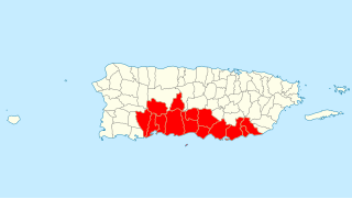
Porta Caribe is a tourism region in southern Puerto Rico. It was established in 2003 by the Puerto Rico Tourism Company, an agency of the Government of Puerto Rico. When created in 2003 it consisted of 14 municipalities in the south central zone. With the creation of the neighboring Porta Cordillera zone in July 2012, the municipalities of Adjuntas and Jayuya were transferred to the newly created Porta Cordillera zone and Porta Caribe became a 12-municipality tourism region. The name Porta Caribe translates to "Doorway to the Caribbean." Its executive director is Maritza W. Ruiz Cabán.

A balneario is an Iberian and Ibero American resort town, typically a seaside resort, and less commonly along the shores of lakes and rivers or next to hot springs. In Spain, balneario typically only refers to spa town resorts. These resorts offer recreation, sports, entertainment, food, hospitality and safety services, retail, and cultural events. These balneario towns are characterized by being flooded by masses of tourists during the summer seasons.

Isla Cardona, also known as Sor Isolina Ferré Island, is a small, uninhabited island located 1.30 nautical miles south of the mainland Puerto Rican shore across from Barrio Playa, on the west side of the entrance to the harbor of Ponce, Puerto Rico. The small island is considered part of barrio Playa. It is home to the 1889 Cardona Island Light, which is listed in the U.S. National Register of Historic Places. Together with Caja de Muertos, Gatas, Morrillito, Ratones, Isla del Frio, and Isla de Jueyes, Cardona is one of seven islands ascribed to the municipality of Ponce. The island gained notoriety in 2010 when the Puerto Rican Bird Society made it a target for the eradication of the black rat.

Gladys Esther Tormes González is a historian and head archivist of the Archivo Histórico de Ponce, in Ponce, Puerto Rico. Serving since 1974, she is the longest-serving archivist in the municipality of Ponce.
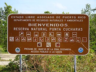
Reserva Natural Punta Cucharas is a nature reserve in Barrio Canas, Ponce, Puerto Rico. It consists of both a land area component as well as an offshore marine area. The land component has an area of 698 cuerdas while the marine component has an expanse of 3,516 cuerdas, for a total area of 4,214 cuerdas. The Reserve consists of mangrove ecosystems, coastal sand dunes, a saline lagoon known as Laguna Las Salinas, open water, and a century-old local community. The lagoon occupies and area of 347,898 m2 Ecological protection is managed and enforced by the Puerto Rico Department of Natural and Environmental Resources. Eight activities are allowed at the Reserve: scuba diving, boating, fishing, hiking, sun bathing, photography, bird watching and canoeing. Activities prohibited are: Camping, crabbing/trapping, horseback riding, water crafting, and hunting. Pets, ATVs, and fireplaces are also prohibited.
Tomás de Renovales was a Spanish military commander for the southern region of Puerto Rico in the first half of the 19th century and de facto Mayor of the city of Ponce in 1831. He held the rank of colonel.

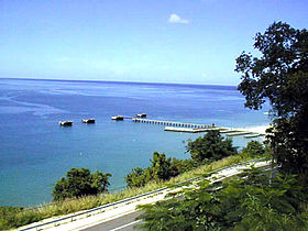
Bahía de Ponce is a bay in Barrio Playa, Ponce, Puerto Rico. The Bay is home to the most important commercial harbor on the Puerto Rico south coast and the second largest in Puerto Rico. The Cardona Island Light is located on the Bay to mark the way into the Bay from the nearby Caja de Muertos Light.
Fuerte de San José, also known as Fuerte de la Playa de Ponce, was an 18th-19th-century Spanish fortress located in Barrio Playa in the municipality of Ponce, Puerto Rico. It was part of a three-fort system design to defend the Port of Ponce, the Barrio Playa seaport village and the City of Ponce from seaborne attacks. However, only two of the three fortifications materialized, with Fuerte San José being the largest and most complete. The fort was in operation 125 years, from 1760 to 20 March 1885, and was demolished in 1907 by order of the Puerto Rico Legislature to make room for the growing civilian population of Barrio Playa. Fuerte de San José has been compared to Fortín de San Gerónimo in San Juan, in terms of design, purpose and size.
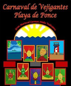
The Carnaval de Vejigantes, officially Carnaval de Vejigantes de La Playa de Ponce, is an annual celebration held at Barrio Playa in Ponce, Puerto Rico. The celebration, which commonly lasts three to five days, generally takes place in late January or early February. It started in 1991. It takes place at Parque Lucy Grillasca on PR-585 in Barrio Playa. The parade, one of the highlights of the carnival, usually takes off from Cancha Salvador Dijols on Avenida Hostos (PR-123) and ends at Parque Lucy Grillasca (PR-585). Attendance is estimated at over 15,000 people. It is attended by people from all over Puerto Rico, and some attendees are from as far as the United States. It is organized and operated by a community, civic, NGO group, not by any government or government agency.
Nature Reserve of Puerto Rico is a title and special designation given by the upper house of the Legislative Assembly of Puerto Rico to specific natural areas or features throughout the territory. All nature reserves in Puerto Rico are protected by Puerto Rico Law #150, first approved on August 8, 1988, better known as the Puerto Rico Natural Heritage Program Act that seeks to protect the natural resources of the island for the purpose of natural preservation and tourism. These are managed by different agencies within the Puerto Rico Department of Natural and Environmental Resources, public-private partnerships such as the Conservation Trust of Puerto Rico and its management unit Para la naturaleza, and other grassroots and community institutions and programs.