
Aguadilla, founded in 1775 by Luis de Córdova, is a city and municipality located in the northwestern tip of Puerto Rico, bordered by the Atlantic Ocean to the north and west, north of Aguada, and Moca and west of Isabela. Aguadilla is spread over 15 barrios and Aguadilla Pueblo. It is a principal city and core of the Aguadilla-Isabela-San Sebastián Metropolitan Statistical Area.

Arecibo is a city and municipality on the northern coast of Puerto Rico, on the shores of the Atlantic Ocean, located north of Utuado and Ciales; east of Hatillo; and west of Barceloneta and Florida. It is about 50 miles (80 km) west of San Juan, the capital city. Arecibo is the largest municipality in Puerto Rico by area, and it is the core city of the Arecibo Metropolitan Statistical Area and part of the greater San Juan–Bayamón, PR Combined Statistical Area. It is spread over 18 barrios and Arecibo Pueblo. Its population in 2020 was 87,754.

Lajas is a town and municipality of Puerto Rico located in the Lajas Valley in southwestern Puerto Rico, on the southern coast of the island, bordering the Caribbean Sea, south of San Germán and Sabana Grande; east of Cabo Rojo; and west of Guánica. Lajas is spread over 11 barrios plus Lajas Pueblo. It is part of the San Germán-Cabo Rojo Metropolitan Statistical Area.

Cabo Rojo is a city and municipality situated on the southwest coast of Puerto Rico and forms part of the San Germán–Cabo Rojo metropolitan area as well as the larger Mayagüez–San Germán–Cabo Rojo Combined Statistical Area.

Camuy is a town and municipality of Puerto Rico, bordering the Atlantic Ocean, north of Lares and San Sebastián; east of Quebradillas; and west of Hatillo. Camuy is spread over 12 barrios and Camuy Pueblo. The town celebrated its 200th anniversary in 2007.

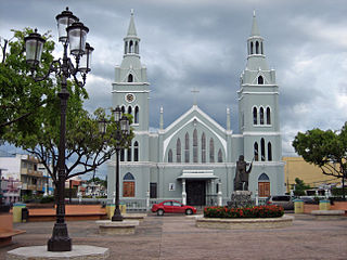
Isabela is a town and municipality of Puerto Rico located in the north-western region of the island, north of San Sebastián; west of Quebradillas; and east of Aguadilla and Moca. It is named in honor of Queen Isabella I of Castile. Isabela is spread over 13 barrios and Isabela Pueblo, which is the downtown area and administrative center. It is a principal part of the Aguadilla-Isabela-San Sebastián Metropolitan Statistical Area.
Aguada, originally San Francisco de Asís de la Aguada, is a town and municipality of Puerto Rico, located in the northwestern coastal valley region bordering the Atlantic Ocean, east of Rincón, south of Aguadilla, west of Moca; and north of Añasco and Mayagüez. It is part of the Aguadilla-Isabela-San Sebastián Metropolitan Statistical Area. Aguada's population is spread over 17 barrios and Aguada Pueblo.

Barceloneta is a town and municipality in Puerto Rico located in the north region, bordering the Atlantic Ocean, north of Florida, east of Arecibo, and west of Manatí. Barceloneta is spread over 3 barrios and Barceloneta Pueblo. It is part of the San Juan-Caguas-Guaynabo Metropolitan Statistical Area.

Guayanilla is a town and municipality of Puerto Rico located on the southern coast of the island, bordering the Caribbean Sea, south of Adjuntas, east of Yauco; and west of Peñuelas and about 12 miles (19 km) west of Ponce. Guayanilla is spread over 16 barrios and Guayanilla Pueblo. It is part of the Yauco Metropolitan Statistical Area.

Manatí is a city and municipality of Puerto Rico on the northern coast, north of Morovis and Ciales; east of Florida and Barceloneta; and west of Vega Baja. Manatí is spread over 8 barrios and Manatí barrio-pueblo. It is part of the San Juan-Caguas-Guaynabo Metropolitan Statistical Area.
San Sebastián is a town and municipality of Puerto Rico located in the northwestern region of the island, south of Isabela, Quebradillas and Camuy; north of Las Marías; east of Moca and Añasco; and west of Lares. San Sebastián is spread over twenty-four barrios and San Sebastián Pueblo. It is a principal city of the Aguadilla-Isabela-San Sebastián Metropolitan Statistical Area.

Guayama, officially the Autonomous Municipality of Guayama, is a city and municipality on the Caribbean coast of Puerto Rico. As of the 2020 U.S. Census, the city had a population of 36,614. It is the center of the Guayama metropolitan area with a population of 68,442 in 2020.
Quebradillas is a town and municipality of the island of Puerto Rico located in the northern shore bordering the Atlantic Ocean, north of San Sebastián; east of Isabela; and west of Camuy. Quebradillas is spread over seven barrios and Quebradillas Pueblo. It is part of the San Juan-Caguas-Guaynabo Metropolitan Statistical Area.

Boquerón is a barrio in the municipality of Cabo Rojo, Puerto Rico. Its population in 2010 was 5,373. The village of Boquerón, located on the Boquerón Bay is one of the main tourist attractions in the southwestern part of the island. In 2000, its population was 4,963.

Porta del Sol, or simply West Region, is a tourism region in western Puerto Rico. Porta del Sol was the first tourism region to be established by the Puerto Rico Tourism Company. It consists of 17 municipalities in the western area: Quebradillas, Isabela, San Sebastián, Moca, Aguadilla, Aguada, Rincón, Añasco, Mayagüez, Las Marías, Maricao, Hormigueros, San Germán, Sabana Grande, Guánica, Lajas and Cabo Rojo.

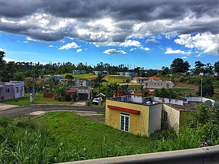
Bajura is a barrio in the municipality of Isabela, Puerto Rico. Its population in 2010 was 663.
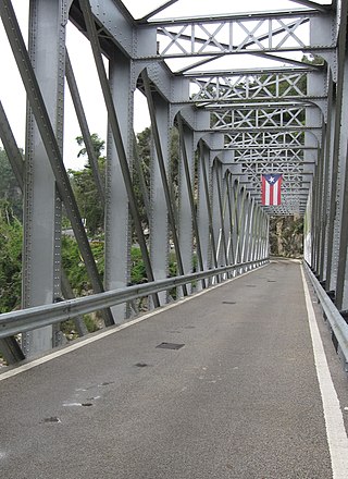
Hato Viejo is a barrio in the municipality of Ciales, Puerto Rico. Its population in 2010 was 2,442. Hato Viejo has more than a dozen sectors, a historic bridge, and folklore about a boy and a cave.

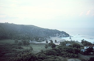
Jobos Beach or Playa Jobos is a beach facing the Atlantic Ocean located on the PR-466 street of Isabela in the northwest of Puerto Rico. While popular, the beach is dangerous and signs warning tourists of dangerous currents were installed in early 2021.
