
San Juan is the capital city and most populous municipality in the Commonwealth of Puerto Rico, an unincorporated territory of the United States. As of the 2020 census, it is the 57th-largest city under the jurisdiction of the United States, with a population of 342,259. San Juan was founded by Spanish colonists in 1521, who called it Ciudad de Puerto Rico.

The following is an alphabetical list of articles related to the Commonwealth of Puerto Rico.

Las Piedras, is a town and municipality in east Puerto Rico located in the central eastern region of the island, north of Yabucoa; south of Canóvanas and Río Grande; east of Juncos and San Lorenzo; and west of Naguabo and Humacao. Las Piedras is spread over 7 barrios and Las Piedras Pueblo. It is part of the San Juan-Caguas-Guaynabo Metropolitan Statistical Area.
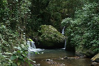
Maricao State Forest is a state forest located in the eastern Cordillera Central mountains of Puerto Rico. It is commonly known as Monte del Estado due to the fact that it was one of the first forest reserves in Puerto Rico to be designated a state forest in its official name. With an area of 10,803 acres (43.72 km2), the Maricao State Forest is the largest of the 20 forestry units of the Puerto Rico state forest system.
Cueva de Los Indios, also known as the Cueva Punta Maldonado site, in the municipality of Loíza, Puerto Rico, was listed on the National Register of Historic Places in 1982.

This is a list of properties and districts in the southern municipalities of Puerto Rico that are listed on the National Register of Historic Places. It includes places along the southern coast of the island, and on the south slope of Puerto Rico's Cordillera Central.
Paso del Indio Site, also known as VB-4, is an archeological site in Vega Baja, Puerto Rico. It was listed on the U.S. National Register of Historic Places in 2007.

Cueva Lucero is a cave and archeological site in the Guayabal barrio of the Juana Díaz municipality, in Puerto Rico. The cave includes more than 100 petroglyphs and pictographs "making it one of the best examples of aboriginal rock art in the Antilles." It has been known to archeologists since at least the early 1900s. Most of its images are zoomorphic. The site is known to locals including rock-climbers and spelunkers and there is some modern graffiti.

Mercado de las Carnes, also known as La Plaza de los Perros, but formally, Plaza Juan Ponce de León, was the first building in Puerto Rico to mix social and architectural elements via the pedestrian mall concept. The historic Art Deco architecture structure is located in Ponce, Puerto Rico, and dates from 1926. It was listed on the National Register of Historic Places in 1986. The Plaza was rebuilt in 1992, under the administration of Mayor Churumba. It is located in the alley connecting Mayor and Leon streets, in the block between Estrella and Guadalupe streets. The Plaza and the alley are one and the same.
The Carretera Central is a historic north–south central highway in Puerto Rico, linking the cities of San Juan and Ponce by way of Río Piedras, Caguas, Cayey, Aibonito, Coamo, and Juana Díaz. It crosses the Cordillera Central. Plans for the road started in the first half of the 19th century, and the road was fully completed in 1898. At the time the United States took possession of Puerto Rico in 1898, the Americans called it "the finest road in the Western Hemisphere."

This portion of National Register of Historic Places listings in Puerto Rico is along the central mountain region, from Las Marías and Maricao in the central-west to Juncos in the central-east, including the slopes of the Cordillera.

This portion of National Register of Historic Places listings in Puerto Rico covers the eastern region of Puerto Rico, from Carolina in the northeast to Arroyo in the southeast. It also includes the islands of Culebra and Vieques.
Rafael Carmoega Morales (1894–1968) was a Puerto Rican architect from Rio Piedras, Puerto Rico. He was the first Puerto Rican to become State Architect, a position within the Department of the Interior which he held from 1921 to 1936. Carmoega was one of the most accomplished Puerto Rican architects of the 20th century.

San Juan Bay is the bay and main inlet adjacent to Old San Juan in northeastern Puerto Rico. It is about 3.5 miles (5.6 km) in length, the largest body of water in an estuary of about 97 square miles (250 km2) of channels, inlets and eight interconnected lagoons. The San Juan Bay is home to the island's busiest harbor and its history dates back to at least 1508.
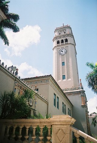
Roosevelt Tower, more popularly known as La Torre, is a 173.54 feet clock tower located above the main entrance to the Baldorioty de Castro Building in the University of Puerto Rico, Río Piedras Campus. The tower is also referred to as El Faro and it is considered a symbol of the University of Puerto Rico and of higher education in Puerto Rico. The tower, along with the main historic quadrangle in campus, have been listed on the National Register of Historic Places since 1984.

The Old Piedras River Aqueduct, also known as the San Juan Waterworks, is an aqueduct in the barrio (district) of El Cinco of San Juan, Puerto Rico. It is by the Piedras River, next to the University of Puerto Rico Botanical Garden. This aqueduct dates to the mid 19th century and it was important for the urban development of Río Piedras.
Cueva del Indio may refer to:

