National Register of Historic Places listings in eastern Puerto Rico

Last updated
National Register entries listed below are found in the highlighted 16 municipalities of Puerto Rico. NRHP list - eastern PR.png
National Register entries listed below are found in the highlighted 16 municipalities of Puerto Rico.

This portion of National Register of Historic Places listings in Puerto Rico covers the eastern region of Puerto Rico, from Carolina in the northeast to Arroyo in the southeast. It also includes the islands of Culebra and Vieques.

Contents

Names of places given are as appear in the National Register, reflecting name as given in NRHP application at the date of listing. Note, the National Register name system does not accommodate Spanish á, ñ and other letters.


    This National Park Service list is complete through NPS recent listings posted May 31, 2024. [1]

Arroyo

[2] Name on the RegisterImageDate listed [3] Location BarrioDescription
1 Faro de Punta de las Figuras
Faro de Punta de las Figuras Faro de Punta de las Figuras north - Arroyo Puerto Rico.jpg
Faro de Punta de las Figuras
October 22, 1981
(#81000687)
Punta de las Figuras, southeast of Arroyo Pueblo
17°57′18″N66°02′52″W / 17.954976°N 66.047657°W / 17.954976; -66.047657 (Faro de Punta de las Figuras)
Palmas Spanish-built Neoclassical lighthouse from 1893, operated by the U.S. Army during the Second World War.

Canóvanas

[2] Name on the RegisterImageDate listed [3] Location BarrioDescription
1 Villarán Bridge
Villaran Bridge Exterior of the Villaran Bridge facing SSW.JPG
Villarán Bridge
July 19, 1995
(#95000835)
Highway 9959, km 3, spanning Río Canóvanas
18°22′45″N65°53′32″W / 18.379213°N 65.892087°W / 18.379213; -65.892087 (Villarán Bridge)
Canóvanas Pueblo and Canóvanas
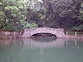
Built in 1892 on the 19th century highway between Río Piedras and Río Grande, this iron and masonry bridge is the best preserved example of an Eiffel pony truss bridge in Puerto Rico or the United States. By 1994, it had been replaced by an adjacent span for vehicular use, but it remained open for pedestrian use. [4]

Carolina

[2] Name on the RegisterImageDate listed [3] Location BarrioDescription
1 Church San Fernando of Carolina
Church San Fernando of Carolina Iglesia San Fernando - Carolina Puerto Rico.jpg
Church San Fernando of Carolina
September 18, 1984
(#84003160)
Muñoz Rivera St., Town Plaza
18°22′52″N65°57′23″W / 18.381072°N 65.956317°W / 18.381072; -65.956317 (Church San Fernando of Carolina)
Carolina PuebloOne of the two churches designed by state engineer Antonio Maria de Vizcarrondo y Guitian. Built between 1860 and 1862.
2 Edificio Alcaldia
Edificio Alcaldia Casa Alcaldia - Carolina Puerto Rico.jpg
Edificio Alcaldia
December 28, 1983
(#83004197)
Sánchez Osorio St. at José de Diego St.
18°22′53″N65°57′27″W / 18.381253°N 65.957427°W / 18.381253; -65.957427 (Edificio Alcaldia)
Carolina PuebloFormer city hall built between 1927 and 1930, designed by Rafael Carmoega in a Spanish Colonial Revival style.
3 Quebrada Maracuto August 27, 2004
(#04000909)
Address restricted [5]
Cacao and Santa Cruz [6] Pre-Columbian site with petroglyphs found across seven boulders in Maracuto Creek. Part of the Prehistoric Rock Art of Puerto Rico MPS.

Ceiba

[2] Name on the RegisterImageDate listed [3] Location BarrioDescription
1 Ceiba Fire Station February 13, 2013
(#13000012)
226 Lauro Piñero Avenue
18°15′59″N65°38′52″W / 18.266333°N 65.647698°W / 18.266333; -65.647698 (Ceiba Fire Station)
Ceiba Pueblo Art Deco fire station from 1954, designed and built by the Department Public Works of Puerto Rico. Part of the Fire Stations in Puerto Rico MPS.

Culebra

[2] Name on the RegisterImageDate listed [3] Location BarrioDescription
1 Faro Isla de Culebritas
Faro Isla de Culebritas Culebrita Lighthouse.jpg
Faro Isla de Culebritas
October 22, 1981
(#81000686)
Isla Culebrita
18°18′49″N65°13′39″W / 18.313694°N 65.227444°W / 18.313694; -65.227444 (Faro Isla de Culebritas)
Fraile 
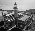
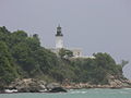
Spanish-built lighthouse from 1882, it used to aid in the navigation through the Virgin Passage and the Vieques Sound. Located in the island of Culebrita, part of the Culebra National Wildlife Refuge.

Fajardo

[2] Name on the RegisterImageDate listed [3] Location BarrioDescription
1 Church Santiago Apóstol of Fajardo
Church Santiago Apostol of Fajardo Catedral Santiago Apostol (5298827913).jpg
Church Santiago Apóstol of Fajardo
September 18, 1984
(#84003144)
Town Plaza
18°19′30″N65°39′11″W / 18.324873°N 65.653066°W / 18.324873; -65.653066 (Church Santiago Apóstol of Fajardo)
Fajardo PuebloA former parish church (now cathedral) from 1776. Part of the Historic Churches of Puerto Rico TR.
2 Faro de las Cabezas de San Juan
Faro de las Cabezas de San Juan Las Cabezas de San Juan Lighthouse2.jpg
Faro de las Cabezas de San Juan
October 22, 1981
(#81000692)
Northeast of Soroco
18°22′53″N65°37′05″W / 18.381457°N 65.618134°W / 18.381457; -65.618134 (Faro de las Cabezas de San Juan)
CabezasSpanish-built lighthouse from 1880, it played an important role in the Puerto Rico campaign of the Spanish–American War. Located in the Las Cabezas de San Juan Nature Reserve.
3 U.S. Custom House
U.S. Custom House Aduana de Fajardo.jpg
U.S. Custom House
February 10, 1988
(#88000077)
Union Street
18°20′02″N65°37′50″W / 18.333942°N 65.630564°W / 18.333942; -65.630564 (U.S. Custom House)
Playa Puerto Real [7] Customs house from 1930, designed by Albert B. Nichols. Also served as a U.S. Post Office throughout its life. Part of the United States Custom Houses in Puerto Rico MPS.

Humacao

[2] Name on the RegisterImageDate listed [3] Location BarrioDescription
1 Casa Roig
Casa Roig Casa Roig 2 - Humacao Puerto Rico.jpg
Casa Roig
November 17, 1977
(#77001550)
66 Antonio López Street
18°08′53″N65°49′30″W / 18.147971°N 65.824867°W / 18.147971; -65.824867 (Casa Roig)
Humacao PuebloA Prairie School building from 1920, designed by Antonin Nechodoma for prominent sugarcane magnate Antonio Roig. Now a Historic house museum operated by the University of Puerto Rico at Humacao.
2 Church Dulce Nombre de Jesús of Humacao
Church Dulce Nombre de Jesus of Humacao Humacao, Puerto Rico church.JPG
Church Dulce Nombre de Jesús of Humacao
September 18, 1984
(#84003140)
Town Plaza
18°09′01″N65°49′34″W / 18.150157°N 65.826199°W / 18.150157; -65.826199 (Church Dulce Nombre de Jesús of Humacao)
Humacao Pueblo Late Gothic Revival cathedral church from 1869. Part of the Historic Churches of Puerto Rico TR.
3 Guzmán Family Pantheon
Guzman Family Pantheon Guzman Family Pantheon.JPG
Guzmán Family Pantheon
April 17, 1995
(#95000436)
Junction of Padre Rivera and Miguel Casillas Streets
18°09′08″N65°49′40″W / 18.152327°N 65.827904°W / 18.152327; -65.827904 (Guzmán Family Pantheon)
Humacao PuebloEclectic style mausoleum and funerary chapel from 1864. Also known as the Guzmán Hermitage.
4 Humacao Customs House
Humacao Customs House Humacao Customs House.JPG
Humacao Customs House
May 18, 1995
(#95000599)
Junction of Marina and Aduana Streets
18°09′54″N65°44′38″W / 18.164909°N 65.743989°W / 18.164909; -65.743989 (Humacao Customs House)
Punta Santiago
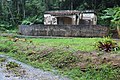
Spanish Colonial building built by the Department of Public Works of the Spanish Government in Puerto Rico in 1872, designed by Julian Cruellas y Rovira to be the Humacao customs house at its port in Punta Santiago.
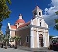
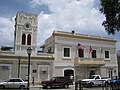
5 Humacao District Courthouse
Humacao District Courthouse Humacao District Courthouse.JPG
Humacao District Courthouse
May 18, 1995
(#95000596)
Junction of Dr. Vidal and Antonio López Streets
18°08′58″N65°49′27″W / 18.149531°N 65.824152°W / 18.149531; -65.824152 (Humacao District Courthouse)
Humacao Pueblo Classical Revival Federal-style courthouse from 1925 designed by Rafael Carmoega. Also served as a city hall, reception venue and currently a local fine arts museum.
6 Palmira López de Pereyó House
Palmira Lopez de Pereyo House Palmira Lopez de Pereyo House en Humacao, Puerto Rico.jpg
Palmira López de Pereyó House
April 14, 1995
(#95000435)
Junction of Font Martelo and Minerva Streets
18°09′02″N65°49′20″W / 18.150545°N 65.822218°W / 18.150545; -65.822218 (Palmira López de Pereyó House)
Humacao Pueblo Prairie School house from 1930 designed by Francisco Valinés Cofresí for Luis Pereyó y Rodríguez, former District judge from Humacao.
7 Antonia Sáez School May 18, 1995
(#95000597)
Junction of Font Martelo and Isidro Ortiz Sreets
18°09′06″N65°49′49″W / 18.151750°N 65.830288°W / 18.151750; -65.830288 (Antonia Sáez School)
Humacao PuebloA Mission/Spanish Revival school from 1922. It also served as a public marketplace between 1966 and 2004.

Las Piedras

[2] Name on the RegisterImageDate listed [3] Location BarrioDescription
1 Cueva del Indio September 4, 2003
(#03000884)
Approximately 1.2 km (0.75 mi) north of Highway 198
18°11′50″N65°52′24″W / 18.1972°N 65.8733°W / 18.1972; -65.8733 (Cueva del Indio)
Quebrada Arenas Site of a former ceremonial ball court (batey) and containing examples of indigenous rock art found throughout large batholitic boulders. Part of the Prehistoric Rock Art of Puerto Rico MPS.

Loíza

[2] Name on the RegisterImageDate listed [3] Location BarrioDescription
1 Roberto Clemente Walker Crash Site August 31, 2022
(#100008070)
PR 187 km. 6, Punta Maldonado and 1.5 nautical mi. offshore in the Atlantic Ocean
18°27′45″N65°57′30″W / 18.4625°N 65.958333°W / 18.4625; -65.958333 (Roberto Clemente Walker Crash Site)
Loíza vicinitySite of the 1972 Puerto Rico DC-7 crash caused by a failed engine, where baseball legend Roberto Clemente died.
2 Cueva de Los Indios June 24, 1982
(#82003823)
Address restricted [5]
Torrecilla BajaWell-preserved small cave with indigenous petroglyphs. Also known as the Cueva Punta Maldonado site, within the management boundaries of Piñones State Forest. Part of the Part of the Prehistoric Rock Art of Puerto Rico MPS.
3 Parroquia del Espiritu Santo y San Patricio [lower-alpha 1]
Parroquia del Espiritu Santo y San Patricio Parroquia del Espiritu Santo y San Patricio.jpg
Parroquia del Espiritu Santo y San Patricio
September 8, 1976
(#76002251)
Plaza de Loíza
18°26′00″N65°52′47″W / 18.433238°N 65.879610°W / 18.433238; -65.879610 (Parroquia del Espiritu Santo y San Patricio)
Loíza PuebloHistoric parish church dating from 1729, representative of the local Afro-Puerto Rican heritage. [8]

Luquillo

[2] Name on the RegisterImageDate listed [3] Location BarrioDescription
1 Williams Products Corporation
Williams Products Corporation The Williams Corporation Building.jpg
Williams Products Corporation
November 14, 2012
(#12000938)
Highway 992, km 0.3
18°22′16″N65°43′07″W / 18.370986°N 65.718615°W / 18.370986; -65.718615 (Williams Products Corporation)
Mata de Plátano Historic factory building from 1957 designed in the Modernist style. Also known as La Williams Factory.

Maunabo

[2] Name on the RegisterImageDate listed [3] Location BarrioDescription
1 Casa Alcaldia de Maunabo
Casa Alcaldia de Maunabo Casa Alcaldia in Maunaba barrio-pueblo, Puerto Rico.jpg
Casa Alcaldia de Maunabo
August 23, 2022
(#100008050)
Calle Santiago Iglesias #8
18°00′25″N65°53′59″W / 18.006922°N 65.899667°W / 18.006922; -65.899667 (Casa Alcaldia de Maunabo)
Maunabo Pueblo Historic city hall building from the early 20th century.
2 Faro de Punta de la Tuna
Faro de Punta de la Tuna Faro Punta Tuna.jpg
Faro de Punta de la Tuna
October 22, 1981
(#81000688)
Southeast of Puerto Maunabo
17°59′18″N65°53′07″W / 17.988370°N 65.885274°W / 17.988370; -65.885274 (Faro de Punta de la Tuna)
Emajagua Historic Neoclassical lighthouse from 1892. Part of the Lighthouse System of Puerto Rico TR.

Naguabo

[2] Name on the RegisterImageDate listed [3] Location BarrioDescription
1 Bridge No. 122
Bridge No. 122 Bridge No. 122.jpg
Bridge No. 122
July 19, 1995
(#95000836)
Highway 3, km 9, spanning the Santiago River
18°11′18″N65°43′30″W / 18.188386°N 65.725108°W / 18.188386; -65.725108 (Bridge No. 122)
Río and HúcaresHistoric reinforced concrete bridge designed by Félix Benítez Rexach spanning the Santiago River notable for its ornamental details.
2 Church Nuestra Señora del Rosario of Naguabo
Church Nuestra Senora del Rosario of Naguabo Church Nuestra Senora del Rosario of Naguabo.JPG
Church Nuestra Señora del Rosario of Naguabo
December 10, 1984
(#84000456)
Town Plaza
18°12′43″N65°44′09″W / 18.212062°N 65.735754°W / 18.212062; -65.735754 (Church Nuestra Señora del Rosario of Naguabo)
Naguabo PuebloOne of the oldest structures in the town of Naguabo, built in 1856 in a Spanish Colonial style with Eclectic ornamentations being added at the beginning of the 20th-century.
3 Icacos Petroglyph Group December 1, 2015
(#15000855)
Address restricted [5]
Address restricted [5] Ensemble of Taino petroglyphs found across several large boulders at the confluence of the Icacos and Cubuy Rivers in El Toro Wilderness of El Yunque National Forest. Also known as the Río Blanco Petroglyphs site.
4 Villa Del Mar
Villa Del Mar VillaDelMarNRHPNaguabo.jpg
Villa Del Mar
June 23, 1983
(#83002293)
Highway 3, km 66.2
18°11′21″N65°42′54″W / 18.189168°N 65.714985°W / 18.189168; -65.714985 (Villa Del Mar)
HúcaresNow ruined 1917 Queen Anne-inspired Criollo-style residence formerly owned by a wealthy sugarcane plantation owner also known as "El Castillo" located in the Malecón of Naguabo.

Patillas

[2] Name on the RegisterImageDate listed [3] Location BarrioDescription
1 María Dávila Semidey School November 14, 2012
(#12000939)
300 Muñoz Rivera Street
18°00′21″N66°01′01″W / 18.005906°N 66.017068°W / 18.005906; -66.017068 (María Dávila Semidey School)
Patillas Pueblo Mission Revival-style school building from 1925, designed by Francisco Gardón Vega.

Río Grande

[2] Name on the RegisterImageDate listed [3] Location BarrioDescription
1 Baño de Oro
Bano de Oro Banodeoro USDA forest service el yunque2.jpg
Baño de Oro
January 21, 2020
(#100004891)
Highway 191, km 12.1
Coordinates missing
Mameyes IIHistoric Civilian Conservation Corps-built visitor infrastructure named after the natural area of the same name in El Yunque National Forest.
2 Baño Grande
Bano Grande Bano Grande, Rio Grande, Puerto Rico.jpg
Baño Grande
February 28, 2017
(#100000685)
Highway 191, km 11.85
18°18′06″N65°47′07″W / 18.301616°N 65.785388°W / 18.301616; -65.785388 (Baño Grande)
Mameyes IIFormer swimming pool built by the Civilian Conservation Corps by damming a section of La Mina River in El Yunque National Forest. Also known as La Mina Pool.
3 Jimenez Petroglyph Site May 28, 2024
(#100008398)
Address Restricted
Río Grande vicinityAncient Taino petroglyph site with rock art uniquely carved onto red clay, located in El Yunque National Forest.
4 Mt. Britton Tower
Mt. Britton Tower Mameyes II, Rio Grande 00745, Puerto Rico - panoramio (25).jpg
Mt. Britton Tower
May 30, 2024
(#100010421)
181 metres (594 ft) southeast of FS Road 10 at km. 1.3
18°18′04″N65°47′36″W / 18.3010°N 65.7932°W / 18.3010; -65.7932 (Mt. Britton Tower)
Río Grande vicinity Civilian Conservation Corps tower located in the summit of Mount Britton, the 8th tallest peak in El Yunque National Forest. Built in the 1930s.
5 Río Grande Fire Station January 29, 2013
(#12001248)
6 Juan R. González Street
18°22′46″N65°49′49″W / 18.379540°N 65.830289°W / 18.379540; -65.830289 (Río Grande Fire Station)
Río Grande PuebloHistoric Art Deco firehouse built in 1951 by the Department of Public Works of Puerto Rico. Part of the Fire Stations in Puerto Rico MPS.

Vieques

[2] Name on the RegisterImageDate listed [3] Location BarrioDescription
1 Rafael Acevedo House March 17, 1994
(#94000249)
Víctor Duteil Street between San José and Baldorioty Streets
18°09′00″N65°26′35″W / 18.149938°N 65.443051°W / 18.149938; -65.443051 (Rafael Acevedo House)
Isabel Segunda 
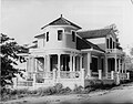
Historic house built in a Neoclassical Vieques Creole-style in 1900, representative of architectural influences from the British and French West Indies. Also known as the Mirella Acevedo Sanes House.
2 Algodones 2 (12VPr2-204) August 21, 1991
(#91001037)
Address restricted [5]
Puerto DiabloAn archeological site of an indigenous village with evidence of inhabitation throughout different cultural periods since 600 CE. Located in the former Vieques Naval Reservation.
3 Algodones 3 (12VPr2-205) August 21, 1991
(#91001038)
Address restricted [5]
Puerto DiabloAnother village archeological site, found within the borders of the Vieques National Wildlife Refuge.
4 Algodones 6 (12VPr2-229) August 21, 1991
(#91001032)
Address restricted [5]
Puerto DiabloAnother village archeological site, found within the borders of the Vieques National Wildlife Refuge.
5 Camp Garcia (Campo Asilo) 3 (12VPr2-164) August 21, 1991
(#91001041)
Address restricted [5]
Puerto FerroSite of petroglyphs, also found within the borders of the Vieques National Wildlife Refuge.
6 Casa Alcaldía de Vieques
Casa Alcaldia de Vieques Casa Alcaldia Isabel Segunda, Vieques PR.jpg
Casa Alcaldía de Vieques
March 17, 1994
(#94000174)
Junction of Carlos LeBrun and Benítez Guzmán Streets
18°08′59″N65°26′30″W / 18.149654°N 65.441606°W / 18.149654; -65.441606 (Casa Alcaldía de Vieques)
Isabel Segunda Former "casa del rey founded in 1850 in the settlement of Isabel Segunda to re-establish Spanish colonial control of the island of Vieques. Today it serves as the municipal city hall.
7 Casa Augusto Delerme February 2, 1994
(#93001555)
7 Benítez Guzmán Street
18°09′00″N65°26′31″W / 18.150084°N 65.441849°W / 18.150084; -65.441849 (Casa Augusto Delerme)
Isabel Segunda A 4-Room Vieques Creole vernacular-style house built in 1850 for a local prominent French-born landowner.
8 Casa Delerme-Anduze No. 2 November 22, 1993
(#93001205)
355 Antonio Mellado Street
18°08′55″N65°26′29″W / 18.148710°N 65.441300°W / 18.148710; -65.441300 (Casa Delerme-Anduze No. 2)
Isabel Segunda A six-room Vieques Creole vernacular-style house from 1876 owned by a wealthy landowner from Guadeloupe.
9 Casa de Jaime Puig Lemoine April 14, 1994
(#94000363)
161 65 de Infantería Street
18°08′55″N65°26′35″W / 18.148680°N 65.442993°W / 18.148680; -65.442993 (Casa de Jaime Puig Lemoine)
Isabel Segunda Bungalow/Craftsman house from 1930, designed by Jaime Puig.
10 Central Playa Grande September 10, 1992
(#92001236)
Address restricted [5]
LlaveAn archaeological site consisting of a former sugarcane plantation and mill with architecture by Matias Hjardemaal and others.
11 Delerme-Anduze House February 2, 1994
(#93001556)
361 Antonio Mellado Street
18°08′55″N65°26′29″W / 18.148601°N 65.441414°W / 18.148601; -65.441414 (Delerme-Anduze House)
Isabel Segunda A vernacular French Caribbean Creole-style gallery house from 1850.
12 Faro de Vieques
Faro de Vieques Punta Mulas (Vieques, Puerto Rico).jpg
Faro de Vieques
November 17, 1977
(#77001551)
Punta Mulas
18°09′16″N65°26′38″W / 18.1545°N 65.4438°W / 18.1545; -65.4438 (Faro de Vieques)
Puerto DiabloSpanish-built lighthouse from 1896. Now also houses a maritime history museum.
13 Fuerte de Vieques
Fuerte de Vieques Vieques pevnost Isabel II.jpg
Fuerte de Vieques
November 18, 1977
(#77001552)
Calle del Fuerte
18°08′51″N65°26′21″W / 18.147436°N 65.439070°W / 18.147436; -65.439070 (Fuerte de Vieques)
Isabel Segunda Well-preserved Spanish-built fortress from 1845 established to provide protection to Isabel Segunda and its harbor. Now it also houses the Vieques Museum of Art and History.
14 Hacienda Casa del Francés
Hacienda Casa del Frances Hacienda Casa del Frances front - Vieques Puerto Rico.jpg
Hacienda Casa del Francés
November 18, 1977
(#77001548)
Near Esperanza
18°06′09″N65°28′15″W / 18.102381°N 65.470786°W / 18.102381; -65.470786 (Hacienda Casa del Francés)
Puerto RealHistoric residence and plantation manor of Henri Muraille from 1910. Also known as the Sportsmen's House. Destroyed by fire in 2005. [10]
15 Laguna Jalova Archeological District September 10, 1992
(#92001237)
Address restricted [5]
Puerto DiabloArchaeological district consisting of different pre-Columbian village sites. Also known as "Western Friendly Front Line".
16 Llave 13 (12VPr2-175) August 21, 1991
(#91001036)
Address restricted [5]
LlavePre-Columbian archaeological site.
17 Loma Jalova 3 (12VPr2-219) August 21, 1991
(#91001034)
Address restricted [5]
Puerto DiabloPre-Columbian archaeological site.
18 Monte Largo 2 (12VPr2-172) August 21, 1991
(#91001042)
Address restricted [5]
Puerto DiabloPre-Columbian archaeological site.
19 Paramayon 2 September 10, 1992
(#92001241)
Address restricted [5]
LlavePre-Columbian archaeological site.
20 Le Pistolet (12VPr2-168) August 22, 1991
(#91001040)
Address restricted [5]
Punta ArenasPre-Columbian archaeological site.
21 Playa Grande 9 (12VPr2-212) August 21, 1991
(#91001035)
Address restricted [5]
LlavePre-Columbian archaeological site.
22 Playa Vieja September 10, 1992
(#92001235)
Address restricted [5]
Punta ArenasArchaeological evidence of prehistoric human inhabitation, particularly from the Saladoid and Ostionoid cultures. Also known as Site 12VPr2-70.
23 Punta Jalova September 10, 1992
(#92001239)
Address restricted [5]
Puerto DiabloPre-Columbian archaeological site.
24 Resolucion Historic District [lower-alpha 2] September 10, 1992
(#92001242)
Address restricted [5]
Punta ArenasIndustrial archaeological site of the first sugarcane plantations and mills established in the island of Vieques and designed by T. J. J. M. Le Guillou and others. [11]
25 Smaine–Ortiz House February 2, 1994
(#93001554)
341 Antonio Mellado Street
18°08′49″N65°26′29″W / 18.146970°N 65.441358°W / 18.146970; -65.441358 (Smaine–Ortiz House)
Isabel Segunda Vieques Creole vernacular residence. Also known as the Porfirio Ortiz House.
26 Las Tumbas de J. J. María le Guillou August 26, 1994
(#94000923)
Highway 200, near Isabel Segunda
18°09′10″N65°25′57″W / 18.152750°N 65.432444°W / 18.152750; -65.432444 (Las Tumbas de J. J. María le Guillou)
Puerto DiabloGraveyard from 1843 built in a Classical Revival style for the Le Guillou family, who founded the modern municipality of Vieques and established its first modern sugarcane plantations.
27 Ventana Archeological District September 10, 1992
(#92001238)
Address restricted [5]
LlavePre-Columbian archaeological site.
28 Ventana 4 (12VPr2-171) August 21, 1991
(#91001039)
Address restricted [5]
Punta ArenasPre-Columbian archaeological site.
29 Vieques Pharmacy
Vieques Pharmacy ViequesPharmacyNPG.jpg
Vieques Pharmacy
March 2, 1994
(#94000061)
Junction of Carlos LeBrun and Víctor Duteil Streets
18°08′58″N65°26′30″W / 18.149341°N 65.441751°W / 18.149341; -65.441751 (Vieques Pharmacy)
Isabel Segunda Former town general store, pharmacy, post office and customs house, established by the vice-consul of Denmark in Vieques to tighten the ties between the Spanish and Danish Virgin Islands. Today a restaurant.
30 Yanuel 8 (12VPr2-173) August 21, 1991
(#91001043)
Address restricted [5]
Puerto DiabloPre-Columbian archaeological site.
31 Yanuel 9 (12VPr2-220) August 21, 1991
(#91001033)
Address restricted [5]
Puerto DiabloPre-Columbian archaeological site.

Yabucoa

[2] Name on the RegisterImageDate listed [3] Location BarrioDescription
1 Yabucoa Fire Station
Yabucoa Fire Station Parque de Bombas de Yabucoa en Puerto Rico.jpg
Yabucoa Fire Station
February 13, 2013
(#13000015)
22 Luis Muñoz Rivera Street
18°03′07″N65°52′38″W / 18.051979°N 65.877330°W / 18.051979; -65.877330 (Yabucoa Fire Station)
Yabucoa Pueblo Historic Art Deco fire station from 1943. Also known as the Parque de Bombas de Yabucoa.

See also

Notes

  1. The name of the Parroquia del Espiritu Santo y San Patricio is presented here without the accent on "Espíritu" in conformance with the usage in the church's National Register nomination form [8] and Federal Register announcement of listing. [9]
  2. The name of the Resolucion Historic District is presented here without the accent on "Resolución" in conformance with the usage in the site's National Register nomination form [11] and announcement of listing. [12]

Related Research Articles

<span class="mw-page-title-main">National Register of Historic Places listings in Kansas</span>

There are over 1,600 buildings, sites, districts, and objects in Kansas listed on the National Register of Historic Places in Kansas. NRHP listings appear in 101 of the state's 105 counties.

<span class="mw-page-title-main">National Register of Historic Places listings in Los Angeles</span>

This is a list of the National Register of Historic Places in the city of Los Angeles.

<span class="mw-page-title-main">National Register of Historic Places listings in Erie County, Pennsylvania</span>

This is a list of the National Register of Historic Places listings in Erie County, Pennsylvania.

<span class="mw-page-title-main">National Register of Historic Places listings in Cass County, Minnesota</span>

This is a list of the National Register of Historic Places listings in Cass County, Minnesota. It is intended to be a complete list of the properties and districts on the National Register of Historic Places in Cass County, Minnesota, United States. The locations of National Register properties and districts for which the latitude and longitude coordinates are included below, may be seen in an online map.

<span class="mw-page-title-main">National Register of Historic Places listings in Douglas County, Minnesota</span>

This is a list of the National Register of Historic Places listings in Douglas County, Minnesota. It is intended to be a complete list of the properties and districts on the National Register of Historic Places in Douglas County, Minnesota, United States. The locations of National Register properties and districts for which the latitude and longitude coordinates are included below, may be seen in an online map.

<span class="mw-page-title-main">National Register of Historic Places listings in Spotsylvania County, Virginia</span>

This is a list of the National Register of Historic Places listings in Spotsylvania County, Virginia.

<span class="mw-page-title-main">National Register of Historic Places listings in Prince William County, Virginia</span>

This is a list of the National Register of Historic Places listings in Prince William County, Virginia.

<span class="mw-page-title-main">Parroquia del Espíritu Santo y San Patricio</span> Historic place in Loíza, Puerto Rico

The Parroquia del Espíritu Santo y San Patricio, constructed in 1645, is one of Puerto Rico's oldest Catholic parish churches. It is located in the main plaza of the municipality of Loíza, Puerto Rico. The church represents an ethnically distinct community characterized by a rich Afro-Hispanic cultural and folk craft tradition. The structure's massive walls and buttresses helped the building withstand flood and hurricanes and likewise provided the people of Loíza with shelter from such natural disasters. The church, named after Saint Patrick, was enlarged to its present size in 1729.

<span class="mw-page-title-main">National Register of Historic Places listings in northern Puerto Rico</span> Places in northern Puerto Rico listed on the US National Register of Historic Places

This portion of National Register of Historic Places listings in Puerto Rico is along the north coast, north plains, and north slopes of the Cordillera, from Isabela to Guaynabo.

<span class="mw-page-title-main">National Register of Historic Places listings in southern Puerto Rico</span>

This is a list of properties and districts in the southern municipalities of Puerto Rico that are listed on the National Register of Historic Places. It includes places along the southern coast of the island, and on the south slope of Puerto Rico's Cordillera Central.

<span class="mw-page-title-main">Iglesia San Ramón Nonato</span> Historic place in Juana Díaz, Puerto Rico

The Iglesia San Ramón Nonato, in some sources also referred to as Iglesia San Juan Bautista y San Ramón Nonato, is a Roman Catholic parish church in the town plaza of Juana Díaz, Puerto Rico.

<span class="mw-page-title-main">National Register of Historic Places listings in western Puerto Rico</span> Places in western Puerto Rico listed on the US National Register of Historic Places

This is a list of properties and districts in the western municipalities of Puerto Rico that are listed on the National Register of Historic Places. It includes places along the western coast, and on islands, and on the western slope of Puerto Rico's Cordillera Central.

<span class="mw-page-title-main">National Register of Historic Places listings in central Puerto Rico</span> Places in central Puerto Rico listed on the US National Register of Historic Places

This portion of National Register of Historic Places listings in Puerto Rico is along the central mountain region, from Las Marías and Maricao in the central-west to Juncos in the central-east, including the slopes of the Cordillera.

<span class="mw-page-title-main">National Register of Historic Places listings in Becker County, Minnesota</span>

This is a list of the National Register of Historic Places listings in Becker County, Minnesota. It is intended to be a complete list of the properties and districts on the National Register of Historic Places in Becker County, Minnesota, United States. The locations of National Register properties and districts for which the latitude and longitude coordinates are included below may be seen in an online map.

<span class="mw-page-title-main">National Register of Historic Places listings in San Patricio County, Texas</span>

This is a list of the National Register of Historic Places listings in San Patricio County, Texas.

<span class="mw-page-title-main">National Register of Historic Places listings in San Juan, Puerto Rico</span>

This portion of National Register of Historic Places listings in Puerto Rico covers the municipality of San Juan.

References

  1. National Park Service, United States Department of the Interior, "National Register of Historic Places: Weekly List Actions", retrieved May 31, 2024.
  2. 1 2 3 4 5 6 7 8 9 10 11 12 13 14 15 16 Numbers represent an alphabetical ordering by significant words. Various colorings, defined here, differentiate National Historic Landmarks and historic districts from other NRHP buildings, structures, sites or objects.
  3. 1 2 3 4 5 6 7 8 9 10 11 12 13 14 15 16 The eight-digit number below each date is the number assigned to each location in the National Register Information System database, which can be viewed by clicking the number.
  4. Pumarada O'Neill, Luis (July 31, 1994), National Register of Historic Places Registration Form: Villarán Bridge (PDF), retrieved January 3, 2016.
  5. 1 2 3 4 5 6 7 8 9 10 11 12 13 14 15 16 17 18 19 20 21 22 23 Federal and state laws and practices restrict general public access to information regarding the specific location of this resource. In some cases, this is to protect archaeological sites from vandalism, while in other cases it is restricted at the request of the owner. See: Knoerl, John; Miller, Diane; Shrimpton, Rebecca H. (1990), Guidelines for Restricting Information about Historic and Prehistoric Resources, National Register Bulletin, National Park Service, U.S. Department of the Interior, OCLC   20706997 .
  6. Oficina Estatal de Conservación Histórica (April 1, 2014), Quebrada Maracuto (PDF) (summary sheet), retrieved March 10, 2016.
  7. U.S. Customs Service (1991). Global Trade Talk: The U.S. Customs Service Journal for the International Trade Community. The Service. p. 9-PT183. Retrieved 30 November 2019.
  8. 1 2 Tarr, Jashina Alexandra (July 12, 1976), National Register of Historic Places Inventory — Nomination Form: Parroquia del Espiritu Santo y San Patricio (PDF), retrieved January 7, 2016.
  9. "Department of the Interior, Heritage Conservation and Recreation Service: National Register of Historic Places; Annual Listing of Historic Properties", 44 FR 7416 (February 6, 1979), at p. 7581.
  10. Fundación Puertorriqueña de las Humanidades (January 4, 2010), "Vieques: Casa del Francés Estate", Puerto Rico Encyclopedia, archived from the original on May 12, 2015, retrieved January 12, 2016.
  11. 1 2 Vescelius, Gary S. (July 5, 1980), National Register of Historic Places Registration Form: Resolucion Historic District (redacted PDF), retrieved January 13, 2016.
  12. National Park Service (September 25, 1992), Weekly List of Actions Taken on Properties: 9/14/92 through 9/19/92 (PDF), retrieved January 13, 2016.