The Rafael Cordero Santiago Port of the Americas —Spanish: Puerto de las Américas Rafael Cordero Santiago (PLA)— is a megaport currently under construction in Ponce, Puerto Rico. The project aims to convert the current Port of Ponce into a value-added tax-free customs-free international shipping hub similar to, though not as large as, the megaports located in Singapore and Rotterdam. The Port of the Americas is Puerto Rico's main Caribbean port, and, at a depth of 50 feet, it is also the deepest port in the Caribbean.

Agüeybaná II, born Güeybaná and also known as Agüeybaná El Bravo, was one of the two principal and most powerful caciques of the Taíno people in "Borikén" when the Spaniards first arrived in Puerto Rico on November 19, 1493. Agüeybaná II led the Taínos of Puerto Rico in the Battle of Yagüecas, also known as the "Taíno rebellion of 1511" against Juan Ponce de León and the Spanish Conquistadors.

Puerto Rico Highway 2 (PR-2) is a road in Puerto Rico that connects the cities of San Juan and Ponce. At 156 miles (230 km) long, it is Puerto Rico's longest singled-signed highway.

Puerto Rico Highway 12 (PR-12), also called Avenida Malecón, and Avenida Santiago de los Caballeros, is a 6.4-kilometer, limited-access highway entirely located within the city limits of Ponce, Puerto Rico, and connecting Puerto Rico Highway 14 to the La Guancha area in Barrio Playa in Ponce. It is similar to a freeway but has one traffic light near its intersection with PR-14. In addition to its northern and southern terminus, the highway has four full interchange exits: PR-52, PR-2, PR-133/Calle Comercio, and Avenida Las Américas. Since PR-12's southern terminus is at the Port of Ponce, its traffic volume is expected to grow as construction in the new Port of the Americas is completed.

Puerto Rico Highway 14 (PR-14) is a main highway connecting Ponce to Cayey, Puerto Rico. The road runs the same course as the historic Carretera Central. The Ponce-to-Coamo section of PR-14 was built under the direction of Spanish engineer Raimundo Camprubí Escudero.
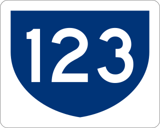
Puerto Rico Highway 123 (PR-123) is a secondary highway that connects the city Arecibo to the city of Ponce. It runs through the towns of Utuado and Adjuntas, before reaching Ponce. A parallel road is being built, PR-10, that is expected to take on most of the traffic currently using PR-123.

Juan Herminio Cintrón García was a Puerto Rican politician and Mayor of Ponce, Puerto Rico, from 1968 to 1972. Under his administration the city of Ponce saw the construction of the Coliseo Juan "Pachín" Vicéns and the Centro Gubernamental de Ponce on Avenida Las Americas.

Río Portugués is a river in the municipality of Ponce, Puerto Rico. In the 19th century, it was also known as Río de Ponce. Twenty-one bridges for motor vehicle traffic span Río Portugués in the municipality of Ponce alone. The river is also known as Río Tibes in the area where it flows through barrio Tibes in the municipality of Ponce. Río Portugués has a length of nearly 30 kilometers (19 mi) and runs south from the Cordillera Central mountain range into the Caribbean Sea. The Portugués is one of the best-known rivers in Ponce because of its prominent zigzagging through the city and its historical significance. The river is historically significant because the city of Ponce had its origins on its banks. It was originally known as Río Baramaya. It has its mouth at 17°58′51″N66°37′26″W. This river is one of the 14 rivers in the municipality.

Avenida Juan Ponce de León, coextensive as Puerto Rico Highway 25 (PR-25) along its entire length, is one of the main thoroughfares in San Juan, Puerto Rico.

Avenida Las Américas, is a major thoroughfare in Ponce, Puerto Rico. Most of its length is signed as Puerto Rico Highway 163 (PR-163). The highway has both of its termini as well as all of its length entirely within the Ponce city limits. It runs west to east. As of 12 November 2010, the segment of this road from its intersection in the west with PR-2R to its intersection in the east with PR-12, officially became the Bulevar Luis A. Ferré. The segment from Avenida Hostos in the east to Carretera Pámpanos (PR-2R) in the west, the first segment built, was built in 1960.

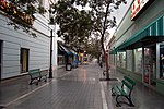
Parque de la Abolición is a city park in Barrio Cuarto, Ponce, Puerto Rico. It was the first park in the Caribbean to commemorate the abolition of slavery. It was built in 1874 and renovated in 1956.

Puerto Rico Highway 9 (PR-9), also called the Anillo de Circunvalación de Ponce, is a limited-access state highway located entirely within the limits of the municipality of Ponce, Puerto Rico, and connecting Puerto Rico Highway 10 in Barrio Portugués in the north to Puerto Rico Highway 52 in barrio Canas in the south, crossing Barrio Magueyes. The Oficina de Ordenación Territorial of the Autonomous Municipality of Ponce calls this road Ronda de Circunvalación Román Baldorioty de Castro. The roadway is still under construction.
The Policía Municipal de Ponce is the main police force for the municipality of Ponce, Puerto Rico, with jurisdiction in the entire municipality, including all 31 barrios of Ponce. It was created in 1867 and reorganized in 1977.
Canas Urbano is one of the 31 barrio of the municipality of Ponce, Puerto Rico. Along with Machuelo Abajo, Magueyes Urbano, Portugués Urbano, and San Antón, Canas Urbano is one of the municipality's five originally rural barrios that are now also part of the urban zone of the city of Ponce. The name of this barrio is of native indigenous origin. It was created in 1953.

Puerto Rico Highway 133 (PR-133) is a major access road in Ponce, Puerto Rico. The road is 1.2 miles long and consists of three segments called "Calle Comercio", "Avenida Cuatro Calles", and "Avenida Ednita Nazario". The road has both of its endpoints, as well as its entire length, within the Ponce city limits. It runs west to east. The road is a main access road from downtown Ponce to PR-1, providing access to Guayama and all other points in the eastern portion of the Puerto Rico, and to PR-52, which provides expressway access to San Juan.

Puerto Rico Highway 585 (PR-585) is tertiary state highway in Ponce, Puerto Rico. The road leads from PR-2R in Sector Pámpanos of Barrio Canas to Avenida Padre Noel in Barrio Playa. It runs west to east, starting from its western terminus at PR-2R and ending at its eastern terminus at PR-123.

Concha Acústica de Ponce is an open-air music and performing arts amphitheater venue in Barrio Cuarto, Ponce, Puerto Rico, owned and managed by the Ponce Municipal Government. It is located on the grounds of Parque de la Abolición. The open-air auditorium-amphitheater is used primarily for cultural events. It is open from Monday through Friday, 8:00AM to 4:30PM. Concha Acústica, as it is known today (2017), is the result of a 1956 redesign that also included the adjacent Monumento a la abolición de la esclavitud. The original design was augmented by this 1956 redesign/renovation by Francisco Porrata-Doría (1890–1971).
Maratón La Guadalupe de Ponce, is a long-distance running event held every year in Ponce, Puerto Rico. Established in 1970, it is the only Olympic marathon held in Puerto Rico.

Puerto Rico Highway 163 (PR-163) is a major two-way thoroughfare in Ponce, Puerto Rico. The road has both of its termini as well as all of its length entirely within the Ponce city limits. The road runs east to west from its eastern terminus at PR-2 in Barrio San Antón to its western terminus at PR-500 in Barrio Canas. The road has a length of 4.8 kilometers. Most of the road runs as part of Avenida Las Américas.

Bahía de Ponce is a bay in Barrio Playa, Ponce, Puerto Rico. The Bay is home to the most important commercial harbor on the Puerto Rico south coast and the second largest in Puerto Rico. The Cardona Island Light is located on the Bay to mark the way into the Bay from the nearby Caja de Muertos Light.