Puerto Rico Highway 2 (PR-2) is a road in Puerto Rico that connects the cities of San Juan and Ponce. At 156 miles (230 km) long, it is Puerto Rico's longest singled-signed highway.
Puerto Rico Highway 10 (PR-10) is a major highway in Puerto Rico. The primary state road connects the city of Ponce in the south coast to Arecibo in the north; it is also the shortest route between the two cities.

Puerto Rico Highway 14 (PR-14) is a main highway connecting Ponce to Cayey, Puerto Rico. The road runs the same course as the historic Carretera Central. The Ponce-to-Coamo section of PR-14 was built under the direction of Spanish engineer Raimundo Camprubí Escudero.
Puerto Rico Highway 123 (PR-123) is a secondary highway that connects the city Arecibo to the city of Ponce. It runs through the towns of Utuado and Adjuntas, before reaching Ponce. A parallel road is being built, PR-10, that is expected to take on most of the traffic currently using PR-123.

Cañas River, also known as Río Cañas, is a river in the municipality of Ponce, Puerto Rico. It is also known as Río Magueyes in the area where it flows through Barrio Magueyes, also in the municipality of Ponce. This river is one of the 14 rivers in the municipality.

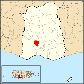
Canas is one of the 31 barrios in the municipality of Ponce, Puerto Rico. Along with Anón, Coto Laurel, Guaraguao, Quebrada Limón, Real, San Patricio, and Marueño, and the coastal barrio of Capitanejo, Canas is one of the municipality's nine bordering barrios. It borders the municipality of Peñuelas. Along with Playa, Bucana, Vayas and Capitanejo, Canas is also one of Ponce's five coastal barrios. It was founded in 1831.

Avenida Las Américas, is a major thoroughfare in Ponce, Puerto Rico. Most of its length is signed as Puerto Rico Highway 163 (PR-163). The highway has both of its termini as well as all of its length entirely within the Ponce city limits. It runs west to east. As of 12 November 2010, the segment of this road from its intersection in the west with PR-2R to its intersection in the east with PR-12, officially became the Bulevar Luis A. Ferré. The segment from Avenida Hostos in the east to Carretera Pámpanos (PR-2R) in the west, the first segment built, was built in 1960.

Puerto Rico Highway 9 (PR-9), also called the Anillo de Circunvalación de Ponce, is a limited-access state highway located entirely within the limits of the municipality of Ponce, Puerto Rico, and connecting Puerto Rico Highway 10 in Barrio Portugués in the north to Puerto Rico Highway 52 in barrio Canas in the south, crossing Barrio Magueyes. The Oficina de Ordenación Territorial of the Autonomous Municipality of Ponce calls this road Ronda de Circunvalación Román Baldorioty de Castro. The roadway is still under construction.

Primero is one of the 31 barrios of the municipality of Ponce, Puerto Rico. Together with Segundo, Tercero, Cuarto, Quinto, and Sexto, Primero is one of the municipality's original six core urban barrios. It was founded in 1878.
Canas Urbano is one of the 31 barrio of the municipality of Ponce, Puerto Rico. Along with Machuelo Abajo, Magueyes Urbano, Portugués Urbano, and San Antón, Canas Urbano is one of the municipality's five originally rural barrios that are now also part of the urban zone of the city of Ponce. The name of this barrio is of native indigenous origin. It was created in 1953.
Magueyes Urbano is one of the 31 barrios in the municipality of Ponce, Puerto Rico. Along with Canas Urbano, Machuelo Abajo, Portugués Urbano, and San Antón, Magueyes Urbano is one of the municipality's five originally rural barrios that are now also part of the urban zone of the city of Ponce. The name of this barrio is of native Indian origin. It was created in 1953.

Puerto Rico Highway 132 (PR-132) is a secondary highway that connects the town of Guayanilla to the city of Ponce, Puerto Rico. The road runs through the town of Peñuelas before reaching Ponce. In Ponce, PR-132 starts where Calle Villa ends.

Puerto Rico Highway 503 (PR-503), also called Carretera Tibes, is a tertiary state road that connects Barrio Consejo, in the southwestern part of the municipality of Utuado, to Barrio Tercero in the city of Ponce, and ending at Museo de la Historia de Ponce, one block east of the center of the city at Plaza Las Delicias.

Puerto Rico Highway 585 (PR-585) is tertiary state highway in Ponce, Puerto Rico. The road leads from PR-2R in Sector Pámpanos of Barrio Canas to Avenida Padre Noel in Barrio Playa. It runs west to east, starting from its western terminus at PR-2R and ending at its eastern terminus at PR-123.

Puerto Rico Highway 511 (PR-511) is a tertiary state highway in the municipality of Ponce in Puerto Rico. With a length of 16.4 km (10.2 mi), it extends from PR-14 between barrios Coto Laurel and Real to PR-143 between Ponce and Jayuya.

Puerto Rico Highway 501 (PR-501) is a tertiary state highway in Ponce, Puerto Rico. The road runs north to south, and mostly alongside Rio Pastillo in barrio Marueño. It southern terminus is at PR-123, just off Calle 18 of Urbanización Las Delicias in barrio Magueyes, and its northern end is also at PR-123 but in barrio Guaraguao.

Puerto Rico Highway 505 (PR-505) is a tertiary state highway in Ponce, Puerto Rico.

Puerto Rico Highway 516 (PR-516) is a tertiary state highway in the northern area of barrio Guaraguao in Ponce, Puerto Rico, near Ponce's border with Adjuntas's barrio Portugués. The road travels east to west. It starts at its intersection with PR-123 and heads west to end at Ponce's border with Peñuelas, from where PR-391 picks up into the municipality of Peñuelas. The road runs through dense mountain vegetation into the interior regions of barrio Guaraguao.

Puerto Rico Highway 163 (PR-163) is a major two-way thoroughfare in Ponce, Puerto Rico. The road has both of its termini as well as all of its length entirely within the Ponce city limits. The road runs east to west from its eastern terminus at PR-2 in Barrio San Antón to its western terminus at PR-500 in Barrio Canas. The road has a length of 4.8 kilometers. Most of the road runs as part of Avenida Las Américas.

Puerto Rico Highway 549 (PR-549) is a tertiary state road in Ponce, Puerto Rico. The road has both of its endpoints, as well as all of its length, entirely within Barrio Canas in the municipality of Ponce. The road is a country road that runs north to south, entirely in the western portion of Barrio Canas. Its southern terminus is at a dirt path that leads to the westernmost endpoint of PR-500 in Barrio Canas and its northern end is at PR-132 also in Barrio Canas.