Puerto Rico Highway 1

Last updated

PR primary 1.svg PR urban primary 1.svg PR secondary 1.svg Ellipse sign 1.svg

Highway 1

Ruta 1
Map of PR-1.svg
Route information
Maintained by Puerto Rico DTPW
Length128.1 km [1] [2]  (79.6 mi)
Major junctions
South endPR urban primary 123.svg PR-123 in PrimeroSegundo
Major intersections
North endCalle Tanca in San Juan Antiguo
Location
Country United States
Territory Puerto Rico
Municipalities Ponce, Juana Díaz, Santa Isabel, Salinas, Aibonito, Cayey, Cidra, Caguas, Aguas Buenas, Guaynabo, San Juan
Highway system
Ellipse sign 9189.svg PR-9189 PR primary 2.svg PR-2

Puerto Rico Highway 1 (PR-1) is a highway in Puerto Rico that connects the city of Ponce to San Juan. Leaving Ponce, the road heads east and follows a somewhat parallel route along the southern coast of the island heading towards Salinas. At Salinas, the road turns north to cut through the Cordillera Central in its approach to San Juan. Before reaching San Juan, it climbs to make its way to the mountain town of Cayey and then it winds down into the city of Caguas on its final approach to San Juan. [3]

Contents

Route description

Map of the southern terminus of PR-1 in the municipality of Ponce Mapa de la carretera PR-1 en Ponce, Puerto Rico (M1).svg
Map of the southern terminus of PR-1 in the municipality of Ponce

PR-1 starts in Ponce and ends in San Juan. The route connects important cities such as Salinas, Cayey, and Caguas.

In Ponce, PR-1 intersects PR-2 and PR-52. One of the major roads in Ponce that PR-1 does not intersect is PR-10, which is accessible via an alternate route (PR-5506) through Mercedita Airport. A sign on PR-1 alerts drivers on where to get off to access PR-10.

PR-1 passes through a small portion of the central town of Cidra, merely off the border with Cayey; the exit from PR-52 to Guavate is less than 1 hectometer from the town, and going north all structures and buildings off the road on the right are in Cayey, while the road itself and everything on the left is in Cidra until it enters Caguas just passing the junction with PR-787, which connects PR-1 to the rest of Cidra. This means that Cidra can be reached quickly from the main tollway (PR-52) via Exit 32 to Guavate.

PR-1 is an undivided two-lane road, with some exceptions. In Ponce, it is a six-lane divided highway in its intersection with PR-578 and PR-2 in Sabanetas. There is a short segment in Cayey where PR-1 is also a divided highway. It becomes a divided road once again from Caguas to San Juan at a sector known as "La Muda".

PR-1 is roughly parallel to PR-52 throughout its entire length. Prior to PR-52's inauguration, PR-1 was the route of choice from traveling between Ponce and San Juan.

Signing

PR-1 is signed "PR-1 East" in the segment that travels from Ponce to Salinas, and then signed "PR-1 North" in the segment that travels from Salinas to San Juan. Likewise, the road is signed "PR-1 South" in the segment that travels from San Juan to Salinas and then signed "PR-1 West" in the segment that travels from Salinas to Ponce.

History

Construction of what became PR-1 began with the building of the Carretera Central , started during the governorship of Miguel de la Torre (1822-1837). [4] A small section from San Juan to Río Piedras was then started. [5] The Carretera Central proceeds south to Cayey along the route of the PR-1, then diverges, and was completed in 1887, taking over 50 years to complete. [4] The Road was also known as La Carretera Militar (The Military Road). [4] The modern PR-1 was opened on 10 March 1907. [6]

Major intersections

All exits are unnumbered.

MunicipalityLocationkm [1] [2] miDestinationsNotes
Ponce PrimeroSegundo line128.179.6South plate (es).svg
PR urban primary 123.svg
PR-123 south (Calle Villa) Ponce
Southern terminus of PR-1; one-way street; northbound access via Calle Reina Isabel
Segundo 127.779.3Ellipse sign 14R.svg PR-14R (Calle Unión) Ponce One-way street
TerceroQuinto line127.379.1North plate (es).svg
PR urban primary 14.svg
PR-14 north (Calle Salud) Juana Díaz
One-way street
Tercero 127.0–
126.9
78.9–
78.9
East plate (es).svg
PR urban primary 1P.svg
PR-1P east (Calle Cristina) Ponce
One-way street; PR-1P eastbound access via Calle Montaner
Río Portugués 126.978.9 Puente de los Leones
San Antón 126.478.5South plate blue (es).svg
PR primary 12.svg
PR-12 south (Avenida Santiago de los Caballeros) Playa
Incomplete diamond interchange; southbound exit and entrance
125.3–
125.2
77.9–
77.8
West plate (es).svg
PR urban primary 2.svg
North plate (es).svg
PR urban primary 133.svg
PR-2 west (Ponce Bypass) / PR-133 north (Avenida Ednita Nazario) Ponce, Peñuelas, Mayagüez
Vayas 123.876.9PR primary 52.svg PR-52 (Autopista Luis A. Ferré) Juana Díaz, San Juan, Mayagüez PR-52 exits 101A and 101B; cloverleaf interchange
VayasSabanetas line122.676.2North plate (es).svg
PR urban primary 5506.svg
Airport Sign.svg PR-5506 north Aeropuerto Mercedita
Juana Díaz Río Jacaguas 117.9–
117.8
73.3–
73.2
Puente Juan Ponce de León [7]
CapitanejoCintrona line114.371.0Ellipse sign 149.svg PR-149  Juana Díaz
Santa Isabel Boca Velázquez 104.7–
104.6
65.1–
65.0
East plate county (es).svg
PR secondary 161.svg
PR-161 east (Desvío Norte Luis Muñoz Marín) San Juan, Salinas, Coamo
Santa Isabel barrio-pueblo 102.963.9North plate county (es).svg
PR secondary 153.svg
PR-153 north (Calle Eugenio María de Hostos) Coamo
One-way street
Felicia 1 102.063.4West plate county (es).svg
PR secondary 161.svg
PR-161 west (Desvío Norte Luis Muñoz Marín) Ponce
Salinas Río Nigua 91.4–
91.3
56.8–
56.7
Puente de los Poleos [7]
Salinas barrio-pueblo 90.856.4East plate county (es).svg
PR secondary 3.svg
PR-3 east (Calle Doctor Santos P. Amadeo) Guayama
89.855.8Ellipse sign 180.svg PR-180 (Avenida Pedro Albizu Campos) Guayama
Lapa 89.255.4PR primary 52.svg PR-52 (Autopista Luis A. Ferré) Ponce, San Juan PR-52 exit 65
Aibonito
No major junctions
Salinas
No major junctions
Aibonito Cuyón 69.142.9Ellipse sign 162.svg PR-162  Aibonito
Cayey Pedro AvilaPasto Viejo line66.041.0West plate county (es).svg
PR secondary 7722.svg
PR-7722 west (Ruta Panorámica) Aibonito
Southern terminus of the Ruta Panorámica concurrency
SumidoMatón Arriba line61.138.0Ellipse sign 715.svg PR-715 (Ruta Panorámica) Cercadillo Northern terminus of the Ruta Panorámica concurrency; the Ruta Panorámica continues toward Guayama
Matón Arriba 60.337.5North plate (es).svg
PR urban primary 206.svg
To plate (es).svg
Ellipse sign 170.svg
PR-206 north to PR-170 (Avenida Roberto Díaz) Cayey, Aibonito
Seagull intersection
Quebrada ArribaMonte Llano
Cayey barrio-pueblo tripoint
58.436.3PR urban primary 15.svg PR-15  Cayey, Guayama
Monte LlanoCayey barrio-pueblo line56.7–
56.6
35.2–
35.2
South plate (es).svg
PR urban primary 7715.svg
To plate blue (es).svg
PR primary 52.svg
PR-7715 south to PR-52 (Autopista Luis A. Ferré) San Juan, Ponce
PR-52 exit 39; roundabout
55.534.5West plate (es).svg
PR urban primary 14.svg
PR-14 west (Carretera Central) Cayey
Southern terminus of the Carretera Central concurrency; the Carretera Central continues toward Aibonito
55.334.4North plate (es).svg
PR urban primary 735.svg
PR-735 north (Carretera Central) Cidra
Northern terminus of the Carretera Central concurrency; seagull intersection
Vegas 53.633.3West plate county (es).svg
PR secondary 735.svg
PR-735 west (Carretera Central) Cidra
Southern terminus of the Carretera Central concurrency
Cidra Beatriz 50.431.3South plate county (es).svg
PR secondary 184.svg
PR-184 south Patillas, Guavate
Caguas Quebrada Las Quebradillas41.025.5Puente Las Quebradillas [7]
Turabo 37.523.3PR urban primary 32.svg PR-32 (Avenida Luis Muñoz Marín) Cidra, San Lorenzo
Caguas barrio-pueblo 36.9–
36.8
22.9–
22.9
West plate (es).svg
PR urban primary 172.svg
Hospital sign.svg PR-172 west (Avenida Pino) Cidra
36.522.7PR urban primary 34.svg PR-34 (Avenida Federico Degetau) San Juan, San Lorenzo
35.922.3PR urban primary 33.svg PR-33 (Avenida José Mercado) Aguas Buenas, San Lorenzo
35.321.9East plate (es).svg
PR urban primary 183.svg
PR-183 east (Calle Eduardo Georgetti) San Lorenzo
One-way street
35.021.7West plate (es).svg
PR urban primary 156.svg
PR-156 west (Calle Ramón Emeterio Betances) Aguas Buenas
One-way street; westbound access via Calle Segundo Ruiz Belvis
34.5–
34.4
21.4–
21.4
West plate (es).svg
PR urban primary 33.svg
East plate (es).svg
PR urban primary 189.svg
PR-33 west (Avenida José Mercado) / PR-189 east (Avenida José Villares) Aguas Buenas, Gurabo
34.0–
33.9
21.1–
21.1
West plate (es).svg
PR urban primary 196.svg
PR-196 west (Avenida Garrido) Aguas Buenas
33.3–
33.2
20.7–
20.6
East plate (es).svg
PR urban primary 32.svg
PR-32 east (Avenida Luis Muñoz Marín) Gurabo
Bairoa 32.220.0East plate blue (es).svg
PR primary 30.svg
PR-30 east (Expreso Cruz Ortiz Stella) Gurabo, Humacao
Trumpet interchange
31.619.6PR primary 52.svg PR-52 (Autopista Luis A. Ferré) San Juan, Bayamón, Carolina, Cayey, Ponce PR-52 exits 14, 15, 15A and 15B; partial cloverleaf interchange
30.519.0Ellipse sign 798.svg PR-798 (Carretera Central) Río Cañas Northern terminus of the Carretera Central concurrency; the Carretera Central continues toward Guaynabo
Río Cañas 28.918.0Ellipse sign 798.svg PR-798 (Carretera Central) Río Cañas Southern terminus of the Carretera Central concurrency; one-way street; southbound access at km 29.3; the Carretera Central continues toward Caguas
28.517.7Ellipse sign 798.svg PR-798 (Carretera Central) Río Cañas Northern terminus of the Carretera Central concurrency; the Carretera Central continues toward Guaynabo
27.917.3Ellipse sign 175.svg PR-175  Trujillo Alto, Carraízo
26.116.2West plate county (es).svg
PR secondary 797.svg
To plate (es).svg
Ellipse sign 798.svg
PR-797 west to PR-798 (Carretera Central) Aguas Buenas
Aguas Buenas
No major junctions
San Juan Quebrada Arenas 25.916.1Ellipse sign 798.svg PR-798 (Carretera Central) Río Cañas Southern terminus of the Carretera Central concurrency; one-way street; southbound access at PR-797; the Carretera Central continues toward Caguas
Guaynabo Río 23.314.5Ellipse sign 173.svgEllipse sign 8834.svg PR-173  / PR-8834 (Carretera Central) Aguas Buenas, Hato Nuevo, Sonadora Northern terminus of the Carretera Central concurrency; the Carretera Central continues toward San Juan
21.313.2North plate blue (es).svg
PR primary 20.svg
PR-20 north (Expreso Rafael Martínez Nadal) Guaynabo
21.013.0Ellipse sign 169.svgEllipse sign 8834.svg PR-169  / PR-8834 (Carretera Central) Guaynabo, Hato Nuevo, Sonadora Southern terminus of the Carretera Central concurrency; the Carretera Central continues toward Caguas
San Juan Tortugo 19.312.0Ellipse sign 873.svg PR-873 (Carretera Central) Tortugo Northern terminus of the Carretera Central concurrency; the Carretera Central continues toward San Juan
Caimito 17.6–
17.5
10.9–
10.9
PR urban primary 199.svg PR-199 (Avenida Doña Felisa Rincón de Gautier) Guaynabo, Caimito, Cupey Partial cloverleaf interchange
MonacilloMonacillo Urbano line16.410.2PR urban primary 177.svg PR-177 (Avenida Lomas Verdes) Guaynabo, Bayamón, Cupey Partial cloverleaf interchange
Monacillo Urbano 15.0–
14.6
9.3–
9.1
North plate blue (es).svg
PR primary 18.svg
South plate blue (es).svg
PR primary 52.svg
PR-18 north (Expreso Las Américas) / PR-52 south (Autopista Luis A. Ferré) San Juan, Bayamón, Caguas, Ponce
No access to PR-52 from northbound
El Cinco 13.3–
12.9
8.3–
8.0
West plate (es).svg
PR urban primary 21.svg
South plate (es).svg
PR urban primary 176.svg
Hospital sign.svg PR-21 west (Avenida Ingeniero José "Kiko" Custodio) / PR-176 south (Avenida Ana G. Méndez) Guaynabo, Bayamón, Cupey
12.57.8Ellipse sign 8838.svg PR-8838 (Avenida Juan Ponce de León) Cupey Southern terminus of the Carretera Central concurrency; one-way street; southbound access at km 12.9; the Carretera Central continues toward Guaynabo
Río Piedras 12.37.6Puente de Río Piedras [7]
Hato Rey Sur 12.1–
12.0
7.5–
7.5
East plate (es).svg
PR urban primary 3.svg
PR-3 east (Avenida 65 de Infantería) Carolina
Northern terminus of the Carretera Central concurrency
10.86.7PR primary 17.svgTo plate blue (es).svg
PR primary 18.svg
Airport Sign.svg PR-17 (Avenida Jesús T. Piñero) to PR-18 (Expreso Las Américas) San Juan, Carolina
Partial cloverleaf interchange
Hato Rey Norte 9.35.8Ellipse sign 41.svg PR-41 (Calle Eleanor Roosevelt) Hato Rey
9.05.6PR urban primary 23.svg PR-23 (Avenida Franklin Delano Roosevelt) Hato Rey
Santurce 6.4–
6.2
4.0–
3.9
PR primary 22.svgTo plate blue (es).svg
PR primary 18.svg
Airport Sign.svg PR-22 (Autopista José de Diego) to PR-18 (Expreso Las Américas) Bayamón, Caguas, Carolina, Santurce
PR-22 exits 1A and 1B; partial cloverleaf interchange
5.5–
5.4
3.4–
3.4
PR primary 2.svgTo plate (es).svg
Ellipse sign 39.svg
PR-2 to PR-39 (Calle Cerra) Bayamón, Guaynabo, Zona Portuaria, Santurce
Partial cloverleaf interchange; no access to PR-2 eastbound from southbound
3.352.08South plate (es).svg
PR urban primary 16.svg
South plate (es).svg
PR urban primary 25.svg
East plate blue (es).svg
PR primary 26.svg
Airport Sign.svg PR-16 south (Bulevar Román Baldorioty de Castro) / PR-25 south (Avenida Juan Ponce de León) / PR-26 east (Expreso Román Baldorioty de Castro) Santurce, Carolina
Southern terminus of PR-25 and the Carretera Central concurrencies; PR-25 southbound access via PR-16; the Carretera Central continues toward Santurce
Caño de San Antonio3.252.02Puente San Antonio and Puente Guillermo Esteves [7]
San Juan Antiguo 3.051.90North plate (es).svg
PR urban primary 25.svg
North plate (es).svg
PR urban primary 25P.svg
PR-25 north (Avenida de la Constitución) / PR-25P north (Avenida Luis Muñoz Rivera) / PR-Avenida Ashford  San Juan, Condado
Northern terminus of PR-25 and the Carretera Central concurrencies; PR-25 and Carretera Central northbound access via PR-25P; the Carretera Central continues toward San Juan
0.00.0 PR-Calle Tanca  Old San Juan Northern terminus of PR-1
1.000 mi = 1.609 km; 1.000 km = 0.621 mi

See also

Related Research Articles

<span class="mw-page-title-main">Caguas, Puerto Rico</span> City and municipality in Puerto Rico

Caguas is a city and municipality of Puerto Rico located in the Central Mountain Range of Puerto Rico, south of San Juan and Trujillo Alto, west of Gurabo and San Lorenzo, and east of Aguas Buenas, Cidra, and Cayey. Caguas was founded in 1775. The municipality had a population of 127,244 at the 2020 census.

<span class="mw-page-title-main">Cayey, Puerto Rico</span> Town and municipality in Puerto Rico

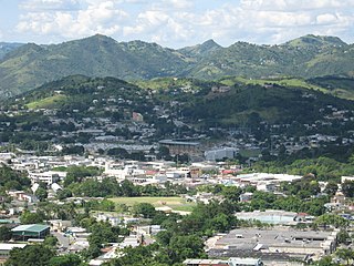
Cayey, officially Cayey de Muesas, is a mountain town and municipality in central Puerto Rico located on the Sierra de Cayey within the Central Mountain range, north of Salinas and Guayama; south of Cidra and Caguas; east of Aibonito and Salinas; and west of San Lorenzo. Cayey is spread over 21 barrios plus Cayey Pueblo. It is part of the San Juan-Caguas-Guaynabo Metropolitan Statistical Area.

<span class="mw-page-title-main">Puerto Rico Highway 52</span> Highway in Puerto Rico

Puerto Rico Highway 52 (PR-52), a major toll road in Puerto Rico, is also known as Autopista Luis A. Ferré. It was formerly called Expreso Las Américas. It runs from PR-1 in southwest Río Piedras and heads south until it intersects with highway PR-2 in Ponce. At its north end, the short PR-18 continues north from PR-52 towards San Juan. This short segment is known as Expreso Las Américas, the only segment of the route still unofficially bearing this name, since PR-18 is officially named Roberto Sánchez Vilella Expressway. The combined route of PR-18 and PR-52 runs concurrent with the unsigned Interstate Highway PRI-1. Toll stations are located in San Juan, Caguas, Salinas, Juana Díaz, and Ponce.

<span class="mw-page-title-main">Puerto Rico Highway 22</span> Highway in Puerto Rico

Puerto Rico Highway 22 (PR-22), also part of unsigned Interstate PR2, is an 84.3 km (52.4 mi) long toll road on the north coast of Puerto Rico that connects the cities of San Juan and Hatillo. The road is also known as the José de Diego Expressway, and is part of unsigned Interstate PR-2. It is a 4-lane road for much of its length, but expands to up to 12 lanes in the San Juan metro area. The road is frequently congested, in particular during rush hour due to heavy commuter traffic.

<span class="mw-page-title-main">Puerto Rico Highway 2</span> Highway in Puerto Rico

Puerto Rico Highway 2 (PR-2) is a road in Puerto Rico that connects the cities of San Juan and Ponce. At 156 miles (230 km) long, it is Puerto Rico's longest singled-signed highway.

<span class="mw-page-title-main">Puerto Rico Highway 3</span> Highway in Puerto Rico

Puerto Rico Highway 3(PR-3) at nearly 100 miles long, is the second-longest highway on Puerto Rico. It connects the San Juan neighborhood of Río Piedras to downtown Salinas indirectly around the eastern coast of the island. Highway 3 ranges from a three lane urban avenue in San Juan to a one lane rural road past Fajardo. While other roads connect San Juan, it runs the coastline of Puerto Rico east of San Juan, beginning in Río Piedras near Santurce and goes to Fajardo where it goes south paralleling the coastline to Humacao and Maunabo. It goes up to a mountain-scenic route and goes west to Salinas, where it meets PR-1.

<span class="mw-page-title-main">Puerto Rico Highway 53</span> Highway in Puerto Rico

Puerto Rico Highway 53 (PR-53) or unsigned Interstate PR3 is a main tollway that is parallel to Puerto Rico Highway 3, which goes from Fajardo to Salinas. Some segments are still in planning, but when finished it will be about 58 miles (93 km) in length. Two tunnels, about 0.6 mi (1 km) long each, in the towns of Yabucoa and Maunabo were completed in October 2008. It will connect the cities of Fajardo, Ceiba, Naguabo, Humacao, Yabucoa, Maunabo, Patillas, Arroyo, Guayama and Salinas, thus bordering the entire eastern and southeastern coasts of Puerto Rico. Its northern terminus is at PR-3 and PR-194 in Fajardo, and its south terminus is at PR-52 in Salinas.

<span class="mw-page-title-main">Puerto Rico Highway 10</span> Highway in Puerto Rico

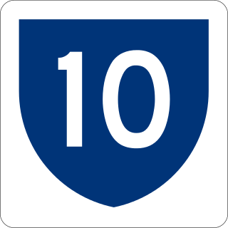
Puerto Rico Highway 10 (PR-10) is a major highway in Puerto Rico. The primary state road connects the city of Ponce in the south coast to Arecibo in the north; it is also the shortest route between the two cities.

<span class="mw-page-title-main">Puerto Rico Highway 12</span> Highway in Puerto Rico

Puerto Rico Highway 12 (PR-12), also called Avenida Malecón, and Avenida Santiago de los Caballeros, is a 6.4-kilometer, limited-access highway entirely located within the city limits of Ponce, Puerto Rico, and connecting Puerto Rico Highway 14 to the La Guancha area in Barrio Playa in Ponce. It is similar to a freeway but has one traffic light near its intersection with PR-14. In addition to its northern and southern terminus, the highway has four full interchange exits: PR-52, PR-2, PR-133/Calle Comercio, and Avenida Las Américas. Since PR-12's southern terminus is at the Port of Ponce, its traffic volume is expected to grow as construction in the new Port of the Americas is completed.

<span class="mw-page-title-main">Puerto Rico Highway 14</span> Highway in Puerto Rico

Puerto Rico Highway 14 (PR-14) is a main highway connecting Ponce to Cayey, Puerto Rico. The road runs the same course as the historic Carretera Central. The Ponce-to-Coamo section of PR-14 was built under the direction of Spanish engineer Raimundo Camprubí Escudero.

<span class="mw-page-title-main">Puerto Rico Highway 184</span> Highway in Puerto Rico

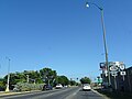
Puerto Rico Highway 184 (PR-184) is a main, rural highway that connects Patillas to Cayey, Puerto Rico, with plans to be extended to Cidra. It extends from PR-3 in Cacao Bajo to PR-1 in Beatriz.

The Ruta Panorámica, officially the Ruta Panorámica Luis Muñoz Marín, is a 167-mile (269 km) network of some 40 secondary roads which traverse the island of Puerto Rico from west to east along its Cordillera Central. Most of the route consists of three roads, PR-105, PR-143, and PR-182. The route starts in Mayagüez and ends in Maunabo. The first major segment of the route runs from Mayagüez to Maricao as Route 105, then from Adjuntas to Aibonito as Route 143, and then follows Route 182 toward Maunabo.

<span class="mw-page-title-main">Arenas Bridge</span> Historic bridge in Cayey and Cidra municipalities, Puerto Rico

The Arenas Bridge is a truss bridge built in 1894 between the municipalities of Cayey and Cidra in Puerto Rico. Also known as Puente Rio La Plata, it was the longest bridge constructed in Puerto Rico during the Spanish colonial period. It crosses the Rio de la Plata, the longest river in Puerto Rico. According to the U.S. National Park Service, "[t]his is the most important metal bridge in Puerto Rico from the period." The bridge is still standing.

The Carretera Central is a historic north–south central highway in Puerto Rico, linking the cities of San Juan and Ponce by way of Río Piedras, Caguas, Cayey, Aibonito, Coamo, and Juana Díaz. It crosses the Cordillera Central. Plans for the road started in the first half of the 19th century, and the road was fully completed in 1898. At the time the United States took possession of Puerto Rico in 1898, the Americans called it "the finest road in the Western Hemisphere."

<span class="mw-page-title-main">Puerto Rico Highway 133</span> Highway in Puerto Rico

Puerto Rico Highway 133 (PR-133) is a major access road in Ponce, Puerto Rico. The road is 1.2 miles long and consists of three segments called "Calle Comercio", "Avenida Cuatro Calles", and "Avenida Ednita Nazario". The road has both of its endpoints, as well as its entire length, within the Ponce city limits. It runs west to east. The road is a main access road from downtown Ponce to PR-1, providing access to Guayama and all other points in the eastern portion of the Puerto Rico, and to PR-52, which provides expressway access to San Juan.

<span class="mw-page-title-main">Puerto Rico Highway 506</span> Highway in Puerto Rico

Puerto Rico Highway 506 (PR-506) is a two-lane tertiary highway in the municipality of Ponce in Puerto Rico. The road runs north to south, joining PR-14, where PR-506 starts, to PR-52 interchange, where it ends. The road is located entirely within Barrio Coto Laurel and its length is 2.0 km (1.2 mi).

<span class="mw-page-title-main">Porta Cordillera</span> Land-locked tourism region in the central mountainous region of Puerto Rico

Porta Cordillera, or simply Central Region, is a land-locked tourism region located in the central mountainous area of Puerto Rico. Porta Cordillera was officially launched in July 2012 by the Puerto Rico Tourism Company. It consists of 16 municipalities: Aguas Buenas, Cidra, Cayey, Comerío, Aibonito, Naranjito, Barranquitas, Corozal, Orocovis, Morovis, Ciales, Jayuya, Florida, Utuado, Adjuntas and Lares.

<span class="mw-page-title-main">Roads in Puerto Rico</span> National, interstate, forest and municipal roadways in Puerto Rico

The Roads in Puerto Rico are the national, forest and municipal roadways that make up the approximately 14,400 kilometers (8,900 mi) roads through the terrain of Puerto Rico. The highways serve the more than 3 million residents, and 3-4 million tourists who visit each year.

References

  1. 1 2 Google (29 March 2020). "PR-1 north" (Map). Google Maps . Google. Retrieved 29 March 2020.
  2. 1 2 Google (29 March 2020). "PR-1 south" (Map). Google Maps . Google. Retrieved 29 March 2020.
  3. Puerto Rico Department of Transportation and Public Works. "Datos de Transito 2000-2009" (in Spanish). Archived from the original on 1 April 2019. Retrieved 29 March 2019.
  4. 1 2 3 Historia de Puerto Rico. Paul Gerard Miller. Capitulo XX. Desarrollo Económico Durante el Siglo XIX. p. 326. New York: Rand McNally. 1922. Retrieved 3 November 2021. Archived.
  5. Historia de la capital de Puerto Rico by Francisco M. Zeno, pg. 95
  6. De San Juan a Cayey en carro público. Toñito Zayas. El Nuevo Día. 15 February 2014. Photo Number 6. Photo Caption. Retrieved 16 February 2014.
  7. 1 2 3 4 5 Luis F. Pumarada O’Neill (1991). "Los Puentes Históricos de Puerto Rico" (PDF) (in Spanish). Retrieved 29 March 2020.