San Juan Antiguo is one of the 18 barrios of San Juan, Puerto Rico. San Juan Antiguo is further divided into 7 subbarrios. San Juan Antiguo is located entirely within the Isleta de San Juan, a small island off the coast of Puerto Rico where the original colonial settlement of San Juan was founded. It is connected to the main island of Puerto Rico by two bridges and a causeway.
The name of the barrio dates to the original foundation of the city of San Juan, originally named Puerto Rico de San Juan Bautista at the moment of its foundation in 1521, San Juan Bautista being the name given to the island of Puerto Rico by the earliest Spanish settlers. By the 18th century, the ambiguous and colloquial use of San Juan Bautista and Puerto Rico for both the city and the island in time led to the unofficial renaming of the island and the city as Puerto Rico and San Juan, respectively.[2] As the city itself further expanded beyond the islet into the towns of Santurce (merged into San Juan by the 19th century) and Río Piedras (merged in the 20th century),[3][4] the barrio was officially named Antiguo to distinguish it from the rest of the modern city.[5] This naming convention of calling an urban core-barrioPueblo Antiguo or Pueblo Viejo is also seen in other municipalities' barrios such as Pueblo Viejo in Guaynabo,[6] the location of the first colonial settlement in both that municipality and the island of Puerto Rico.
The name San Juan Antiguo (Spanish for Old San Juan) refers to the geographical and political subdivision of the municipality of San Juan, not to be confused with Old San Juan (Viejo San Juan), the historic district and tourist attraction located within the barrio itself. Historically, the names San Juan Antiguo and Viejo San Juan were often used interchangeably due to the synonymous nature of the adjectives antiguo and viejo (meaning 'old' or 'ancient'). However, the name San Juan Antiguo is almost never used today to refer to the historic district itself. The name San Juan by itself is often also used to refer to the barrio San Juan Antiguo, with many Puerto Ricans today still referring to the rest of the modern city outside of the isleta as Río Piedras.[4][7]
The first documented inhabitants of the area now known as San Juan Antiguo were the indigenous Taino, with evidence of small fishing villages being found in Puerta de Tierrasubbarrio during the 19th and 20th centuries.[8] The first European settlement of the barrio began on August 8, 1511, when the settlement of Caparra was abandoned in favor of a new town planned across the bay in the southwestern corner of the Isleta de San Juan. The new settlement was officially founded on August 15, 1521. By the end of the 16th century, the town was the fully-functional administrative center for the Spanish colonization of the rest of Puerto Rico and beyond.[9] The establishment of a well-defended port in the San Juan Bay also established the settlement as a key point for the Spanish military, trade and expansion into the New World.[10]
Official Spanish map of San Juan Antiguo during the Spanish–American War
Across its history from its foundation and by the 17th century onwards, the Spanish-founded city of Puerto Rico de San Juan Bautista was coextensive with the modern barrio of San Juan Antiguo. This continued to be the case until the annexation of the town of San Mateo de Cangrejos (now known as the barrio of Santurce) into the city in 1863.[11] The district corresponding to San Juan Antiguo was often mentioned in documents of the time as Puerto Rico de San Juan, Puerto Rico de Puerto Rico, San Juan de Puerto Rico or Plaza de San Juan Bautista when distinguishing it from the wider "town of San Juan",[12] which was now growing to become one of the largest towns in the island. The administrative entity of the barrio emerged after the annexation of Santurce, during the second half of the 19th century, first known as Barrio de San Juan.[13]
In the aftermath of the Spanish–American War, Puerto Rico became a territorial colony of the United States of America.[9] According to the 1899 census of Puerto Rico conducted by the United States War Department, the population of the barrio of San Juan Antiguo (then referred to simply as San Juan Pueblo) was 33,006 inhabitants. With the implementation of new administrative practices during the 20th century, the core urban barrio of each Puerto Rican municipality came to be officially known as Pueblo, which was the case of the name of the barrio used from then on: San Juan Pueblo. In the late 20th century, these Pueblo barrios were officially changed to barrio-pueblo, to explicitly identify them for the context of the 1990 and subsequent US censuses. In the case of the municipality of San Juan, which features multiple urban cores rather than a single center as in most other Puerto Rican municipalities, the name San Juan Antiguo was chosen instead of renaming the barrio to San Juan barrio-pueblo. The name of the barrio Pueblo, located in the now district of Río Piedras, serves as a reminder of that barrio's former status as the urban core of the former municipality of Río Piedras before its annexation to the modern city and municipality of San Juan in 1951.[4] San Juan Antiguo, however, continues to serve as the administrative center for the municipality of San Juan with the San Juan City Hall and numerous other municipal and civic buildings located there.[14]
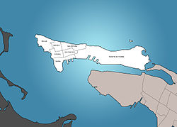
San Juan Antiguo is located entirely within the Isleta de San Juan. Measuring 1.02 square miles (2.6 square kilometers) across, the barrio is coextensive with the isleta. The total jurisdiction including water spans 2.63 square miles (6.8 square kilometers). This total area includes the isleta, several reefs and islets located around the main isleta, and portions of the San Juan Bay, the San Antonio Channel (Caño San Antonio) and the Condado Lagoon.[15]
Despite being located in an islet, the barrio is relatively hilly and rocky, with only the eastern and southern coasts being relatively flat. Due to the continuous levels development of the fortification systems across the islet, its topography has drastically changed throughout its history. At approximately 140 feet (42 m) of elevation above sea level, the former highest point of both the barrio and the islet was located at the promontory of El Morro at the northeastern tip of the islet, now occupied by the Castillo San Felipe del Morro.[16] Another former highest point was located at the current Castillo San Cristóbal. Other elevations include Loma de los Vientos located near the Capitol of Puerto Rico, and Las Ánimas Hill (Loma de las Ánimas), which at 128 feet (39 m) is the highest still-existing natural point of the islet.[17] Although several man-made ditches and drainage systems have been built throughout its history, no natural rivers, creeks or bodies of fresh water have ever existed in San Juan Antiguo.
Cityscape
The urban development of San Juan Antiguo is centered around the subbarrios of Catedral, Mercado, San Cristóbal and San Francisco, located at the east-central portion of the islet of San Juan, particularly around Catedral, the location of the city's main Roman Catholic church and city hall. This urban core represents the original Spanish-founded settlement from around which the rest of the islet was populated. The subbarrios of Ballajá and Marina were later established as part of the development of the military barracks built to supply El Morro Castle and the establishment of the main port of the city of San Juan, respectively. As this urban core was walled-off throughout the development of the fortification system of San Juan, various city gates were built to allow access into the town. The land-facing gate, colloquially known as Puerta de Tierra (Spanish for 'land gate'), gave way to the westward urban sprawl in the city. This district today hosts the Capitol of Puerto Rico,[18] and is the largest and most populated in San Juan Antiguo.[19]
Subbarrios
Subdivisions of San Juan Antiguo
San Juan Antiguo is divided into the following subbarrios:[20]
U.S. Decennial Census 1900 (uses 1899 data)[21] 1910-1930[22] 1930-1950[23] 1980-2000[24] 2010[25]
Throughout its history, San Juan Antiguo was the most densely populated area of the city of San Juan. Its population peaked at 34,637 inhabitants as recorded in the 1920 Census. This changed during the second half of the 20th century, at a time when the city's metropolitan area was growing substantially due to the development of then suburbs such as Río Piedras, Bayamón and Carolina. In 2020, San Juan Antiguo had a population of 6,383 inhabitants and a population density of 2,400 people per km2.[26]
Transportation
San Juan Antiguo is accessible via a network of roads and bridges that connect the islet to the rest of the San Juan metropolitan area. The San Antonio and Dos Hermanos Bridges link the barrio to Santurce and the main island of Puerto Rico. Public transportation includes AMA buses and the free municipal trolley system, which circulates throughout Old San Juan and Puerta de Tierra, providing access to key landmarks and government buildings. While no Tren Urbano stations exist within San Juan Antiguo, nearby Sagrado Corazón station in Santurce offer bus connections between the barrio and the broader metro area. The narrow, historic streets and limited parking encourage walking and the use of the public trolley system, especially within the colonial core. The Port of San Juan, located along the southern waterfront, serves as a major hub for cruise ships and maritime freight. The Cataño Ferry offers service to the nearby town and municipality of Cataño. Former ferry services included connection to Hato Rey and its Tren Urbano station.
↑"Breve historia de la Asamblea Municipal"[Brief history of the Municipal Assembly] (in Spanish). Legislatura Municipal de San Juan. 25 January 2016. Retrieved May 24, 2017.
This page is based on this Wikipedia article Text is available under the CC BY-SA 4.0 license; additional terms may apply. Images, videos and audio are available under their respective licenses.