Puerta de Tierra, San Juan

Last updated
Puerta de Tierra
ISS047-E-783 - View of Puerto Rico.jpg
Satellite image of Puerta de Tierra within San Juan Antiguo alongside Santurce
San Juan Antiguo Sub Barrios.jpg
Puerta de Tierra within San Juan Antiguo
San Juan Antiguo.jpg
San Juan Antiguo shown in yellow within San Juan shown in light gray
Caribbean location map.svg
Red pog.svg
Puerta de Tierra
Puerta de Tierra, San Juan Antiguo, San Juan, Puerto Rico
Coordinates: 18°27′42″N66°05′47″W / 18.46167°N 66.09639°W / 18.46167; -66.09639
Commonwealth Flag of Puerto Rico.svg  Puerto Rico
Municipality Flag of San Juan, Puerto Rico.svg San Juan
Area
  Land0.60 sq mi (1.6 km2)
Population
 (2010)
  Total2,924
Time zone UTC−4 (AST)
Area code(s) 00906
Puerta de Tierra Historic District
The Skyline of San Juan with the Capitol of Puerto Rico.jpg
Puerta de Tierra skyline with the Puerto Rico Capitol in the foreground
Architectural stylevarious
NRHP reference No. 100002936
Added to NRHPOctober 15, 2019

Puerta de Tierra is a subbarrio (subdistrict) occupying the eastern portion of the Islet of San Juan and the barrio of San Juan Antiguo in the municipality of San Juan, Puerto Rico. The name Puerta de Tierra (Spanish for land gate) derives from the former eastern gated entrance to the walled city of San Juan where Plaza Colón (formerly Santiago Square, named after the Puerta de Santiago) is today. With a population of 2,924 as of 2010, this is the most populated area of San Juan Antiguo. On October 15, 2019, it was added to the National Register of Historic Places. [1]

Contents

History

Indigenous history

Before the arrival of the Europeans to Puerto Rico, Puerta de Tierra (along with Old San Juan) formed part of a smaller islet which was populated by the Taíno. Remains of a small indigenous fishing village have been found where the Puerto Rico National Guard Museum stands today, however most archaeological sites in the area have been destroyed and lost during the construction of the Muñoz Rivera Avenue and surrounding buildings. [2]

Spanish colonization

The Spanish began the colonization of Puerto Rico in 1508 when Juan Ponce de León founded Caparra, the first permanent settlement in the island, located in the southern part of the Bay of San Juan (today part of Guaynabo). This Spanish village was abandoned in 1519 when the Spanish founded the settlement of Puerto Rico de San Juan Bautista (modern-day Old San Juan) across the bay. The area where Puerta de Tierra is located became critical for the settlement and the defense of the Islet of San Juan as it represented the closest part of the islet to the main island of Puerto Rico. This area, later referred to as El Boquerón, was separated from the main island by the San Antonio strait (today known as the San Antonio Channel). The first bridge across the San Antonio Channel was built by enslaved Taínos between 1520 and 1521 as entrusted by the Order of Saint Jerome (or Hieronymites). [2]

One of the first witch-hunts in the New World occurred in Puerta de Tierra in 1594 when bishop and inquisitor Don Nicolás Ramos accused a group of people of African descent of celebrating pagan rituals just outside of the settlement of San Juan. The accused were tortured and forced to reject their beliefs, although three women who did not comply were burned at the stake by orders of the Holy Inquisition. [2]

San Juan's eastern expansion

Puerta de Santiago, also known as Puerta de Tierra, today Plaza Colon, is the namesake of this subdistrict. Puerta santiago.jpg
Puerta de Santiago, also known as Puerta de Tierra, today Plaza Colón, is the namesake of this subdistrict.

Construction of the fortified wall system of San Juan began in 1634. Although the area outside the city walls occupying the east side of Old San Juan was almost uninhabited prior to the 19th century, this area represents the first urban expansion of San Juan during the colonial period. Some of the settlers of the area around this time were freed families originating from the British, Dutch and Danish colonies in the Caribbean. While most residences were wooden huts and bohíos, this represents the first eastward demographic expansion of the colonial city of San Juan. Most of the huts were located along the eastern walls and the Puerta de Santiago (Santiago Gate). Due to the fact that this was the main entrance by land to the fortified city, the gate was referred to as Puerta de Tierra. [2]

The area was further settled after the eastward expansion of the batteries of Fort San Cristóbal in 1771 and the construction of the Camino Real (today the Ponce de León Avenue) later in 1810. The area was attacked by the British during the 1797 Battle of San Juan under the command of Sir Ralph Abercromby and Sir Henry Harvey, during the Coalition Anglo-Spanish War. The British invasion was thwarted by the local Spanish militia and regiments of Afro-Puerto Ricans after an unsuccessful siege of San Juan. This event led to the re-fortification of El Boquerón in the eastern end of Puerta de Tierra. Remnants of these military installations can still be seen today in the Luis Muñoz Rivera Park. By 1838, Puerta de Tierra had a population of 168 residents, mainly of African descent. [3]

1867 earthquake and wall demolitions

Although the military installations in San Juan were modernized in 1865, the eastern portion of the walls were no longer deemed necessary due to the eastward expansion of the city and were consequently partially demolished. The 1867 Virgin Islands earthquake destroyed the remaining eastern military installations in the area, and a new road and railway station were built with the name of Paseo Virgen de Nuestra de Señora de Covadonga and the Covadonga Terminal, respectively. The Paseo Covadonga exists today under the name of Covadonga Avenue. [3] The San Juan streetcar system was developed along the Camino Real in 1880, during a time when the southern coast of Puerta de Tierra began to be industrially developed as piers and docks were installed along the San Antonio Channel. During this time, Puerta de Tierra became the most populated area in the Islet of San Juan, which is reflected through the construction of a new parish church (Church of San Agustín), bullfight arenas, schools and new streets. Although the area was quickly developing, most of the residential structures were unplanned, something that also happened along the northern walls of the city in La Perla. [2]

Spanish–American War

The United States took control of Puerto Rico from Spain in the aftermath of the Spanish–American War under the terms of the Treaty of Paris of 1898. In 1899, the United States conducted its first census of Puerto Rico, finding that the population of Puerta de Tierra was 5,453. Puerta de Tierra was badly damaged during the path of the San Ciriaco hurricane (also known as the 1899 Puerto Rico Hurricane). [4]

20th century

San Juan streetcar in 1901. The Street railway journal (1901) (14758136892).jpg
San Juan streetcar in 1901.

Puerta de Tierra went through large changes during the beginning of the 20th century. Barriada Miranda was the first formally established public residential area in the zone in 1903 along the Camino Real, now called the Carretera Central. Politician Luis Muñoz Rivera suggested in 1907 that the territorial capitol of Puerto Rico should be built in the largest of the empty parcels of land where the eastern city walls used to be, next to the Tapia Theater. The first public elementary school, José Julián Acosta School, was also built here in 1907. The portion of this road that passed through Puerta de Tierra was popularly known as the Broadway of Puerto Rico by the media due to the large number of theaters and cultural performing institutions being built at the time. Tres Banderas Theater, for example, was the first cinema to be established in the area in 1910. Some of the first non-Catholic Christian institutions were also established here in the 1910s such as the first Methodist church and the first Lutheran church in San Juan. [2]

The 1928 Okeechobee hurricane (known locally as the San Felipe Segundo hurricane) caused approximately 300 deaths in Puerta de Tierra. This and other disasters such as disease outbreaks negatively affected the development of the area in the first half of the 20th century. Puerta de Tierra and its docks were also the site of large and important workers' protests during this time. The Second World War, however, brought an increase in the industrial activity in the area. The first use of condominiums as public housing in the United States also occurred during this time in Puerta de Tierra, the first of which was the Condominio San Luis, and multi-level housing soon replaced wooden single-family houses. [5]

Cityscape

Historical population
YearPop.±%
18995,453    
1910 10,836+98.7%
1920 15,716+45.0%
1930 11,936−24.1%
193513,356+11.9%
1940 11,480−14.0%
1950 9,114−20.6%
1960 8,075−11.4%
1970 6,143−23.9%
1980 5,522−10.1%
1990 5,366−2.8%
2000 4,135−22.9%
2010 2,924−29.3%
Populations of military and naval reserves are not included from 1899 through 1940.

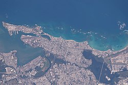
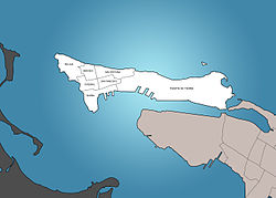
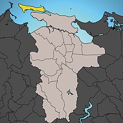
Puerta de Tierra conforms the eastern portion of the Islet of San Juan and it is connected to the mainland by bridges (Dos Hermanos and San Antonio) and a causeway. It is bordered by the Atlantic Ocean to the north, El Boquerón and El Condado to the east, the San Antonio Channel to the south and Old San Juan immediately to the west. Puerta de Tierra is the site of many of Puerto Rico's government buildings, including the Capitol of Puerto Rico. With a 2000 census population of 4,135 and a land area of 0.60 sq. miles (1.55 km²), Puerta de Tierra is the largest and most populous subbarrio of San Juan Antiguo barrio. [6]

In October 2017, Puerta de Tierra won an award from the International Union of Architects, a non-governmental body based in Switzerland which represents the world's architects. Puerta de Tierra was awarded "best public spaces". [7]

Skyline of San Juan with the Capitol of Puerto Rico and Puerta de Tierra in the foreground. The Skyline of San Juan with the Capitol of Puerto Rico.jpg
Skyline of San Juan with the Capitol of Puerto Rico and Puerta de Tierra in the foreground.

National Register of Historic Places

On October 15, 2019, Puerta de Tierra was officially added to the National Register of Historic Places. According to Puerto Rican newspaper El Nuevo Dia, Bibiana Hernández had worked for decades to have Puerta de Tierra added to the US National Register of Historic Places (NRHP) and was overjoyed at the news. Many people such as artist and community spokesman, Jesús “Bubu” Negrón, have worked along with Arleen Pabón-Charneco, a Puerto Rican architect and author of the NRHP nomination forms, to bring more visibility to the area.

The community expressed concerns saying the area was starting to experience gentrification. This designation now makes the entire Isleta de San Juan (San Juan Islet) a historic district, along with the Old San Juan Historic District (which is also on the small isle) and the designation should make it easier to prioritize its care with federal funds for these purposes. There were already thirteen structures in Puerta de Tierra on the NRHP, including El Falansterio, Brambaugh School and the José Celso Barbosa Graded School. [8]

There is a phrase seen on murals around Puerta de Tierra that says Aquí vive gente ("People live here") and the community has been planning to create a museum about Puerta de Tierra. [9]

Attractions

Hotels and Beaches

Parks and Recreation Sites

Government Service Sites

Federal Government of the United States

Commonwealth of Puerto Rico Legislative Branch

Commonwealth of Puerto Rico Judicial Branch

Autonomous Municipality of San Juan

Notable people from Puerta de Tierra

Sites in and around Puerta de Tierra:

See also


Related Research Articles

<span class="mw-page-title-main">San Juan, Puerto Rico</span> Capital and largest city of Puerto Rico

San Juan is the capital city and most populous municipality in the Commonwealth of Puerto Rico, an unincorporated territory of the United States. As of the 2020 census, it is the 57th-largest city under the jurisdiction of the United States, with a population of 342,259. San Juan was founded by Spanish colonists in 1521, who called it Ciudad de Puerto Rico.

<i>El Nuevo Día</i> Puerto Rican daily newspaper

El Nuevo Día is the newspaper with the largest circulation in Puerto Rico. It was founded in 1909 in Ponce, Puerto Rico, and today it is a subsidiary of GFR Media. Its headquarters are in Guaynabo, Puerto Rico.

<span class="mw-page-title-main">José de Diego</span> Puerto Rican politician and writer (1866–1918)

José de Diego y Martínez was a statesman, journalist, poet, lawyer, and advocate for Puerto Rico's political autonomy in union with Spain and later of independence from the United States who was referred to by his peers as "The Father of the Puerto Rican Independence Movement".

<span class="mw-page-title-main">Old San Juan</span> Historic district of San Juan, Puerto Rico

Old San Juan is a historic district located at the "northwest triangle" of the islet of San Juan in San Juan. Its area roughly correlates to the Ballajá, Catedral, Marina, Mercado, San Cristóbal, and San Francisco sub-barrios (sub-districts) of barrio San Juan Antiguo in the municipality of San Juan, Puerto Rico. Old San Juan is the oldest settlement within Puerto Rico and the historic colonial district of the city of San Juan. This historic district is a National Historic Landmark District named Zona Histórica de San Juan and is listed on the United States National Register of Historic Places as the Old San Juan Historic District. Several historical buildings and structures, particularly La Fortaleza, the city walls, and El Morro and San Cristóbal castles, have been inscribed in the UNESCO World Heritage Site list since 1983. Historically the mixed-use commercial and residential real estate in the main streets of Calle Cristo and Calle Fortaleza from Calle Tanca to the Governor’s Mansion is the most valuable in the area and it has kept its value and increased steadily through several years despite the past economic turmoils.

<span class="mw-page-title-main">Fortín de San Gerónimo</span> Small historic fort in San Juan, Puerto Rico

Fortín de San Gerónimo de Boquerón is a small fort located at the mouth of the Condado Lagoon, across from the historic sector of Miramar in San Juan, Puerto Rico.

<span class="mw-page-title-main">Luis Muñoz Rivera Park</span> Park in San Juan, Puerto Rico

The Luis Muñoz Rivera Park is a 27.2 acre recreational public space located in Puerta de Tierra in San Juan, Puerto Rico. The park was named in honor of Puerto Rican statesman Luis Muñoz Rivera. It is the largest public square in the San Juan metropolitan area.

<span class="mw-page-title-main">San Juan National Historic Site</span> U.S. national park site in Puerto Rico

San Juan National Historic Site in the Old San Juan section of San Juan, Puerto Rico, is a National Park Service-managed historic site which preserves and interprets the Spanish colonial-era fortification system of the city of San Juan, and features structures such as the San Felipe del Morro and San Cristóbal fortresses. This fortification system is the oldest European construction under United States jurisdiction and one of the oldest in the New World. This national historic site, together with La Fortaleza, have been designated a UNESCO World Heritage Site since 1983.

<span class="mw-page-title-main">Isleta de San Juan</span> Island with Old San Juan in Puerto Rico

The Isleta de San Juan is a 3-square-mile (7.8 km2) islet or small island on the San Juan Bay in the Atlantic coast of northern Puerto Rico. Home to Old San Juan, it is the site of the oldest permanent European settlement in Puerto Rico (1521), and the second oldest European settlement in the West Indies after Santo Domingo (1496). Due its strategic location in the Caribbean during the Spanish colonization of the Americas, it is home to a city wall and a number of militaristic buildings such as El Morro Castle. Today, it is also home to many of Puerto Rico's government buildings such as the territory's capitol building.

<span class="mw-page-title-main">Capitol of Puerto Rico</span> Government building in San Juan, Puerto Rico

The Capitol of Puerto Rico is located on the Islet of San Juan just outside the walls of Old San Juan. The building is home to the bicameral Legislative Assembly, composed of the House of Representatives and Senate. The building is located in the Puerta de Tierra sector of San Juan. It was built between 1921 and 1929.

<span class="mw-page-title-main">San Juan Antiguo</span> Barrio of San Juan, Puerto Rico

San Juan Antiguo, is a barrio located in the municipality of San Juan in the Commonwealth of Puerto Rico. San Juan Antiguo has 7 subbarrios. In 2010, San Juan Antiguo had a population of 7,085 inhabitants and a population density of 2,681.9 people per km2. San Juan Antiguo is entirely located within the Isleta de San Juan, the islet off the coast of Puerto Rico where Old San Juan was settled, connected to the mainland by bridges and a causeway.

<span class="mw-page-title-main">Segundo Cardona</span> Puerto Rican architect and developer

Segundo Cardona Colom FAIA is a Puerto Rican architect and developer. His work has been recognized by the American Institute of Architects (AIA), by the Colegio de Arquitectos y Arquitectos Paisajistas de Puerto Rico as well as by the International Union of Architects. In 2006 Cardona was elected as Fellow of the American Institute of Architects. In 1992, he was awarded the Henry Klumb Award.

<span class="mw-page-title-main">Paseo de La Princesa</span> Street in the historic district of San Juan, Puerto Rico

Paseo de La Princesa is a pedestrian promenade in San Juan, Puerto Rico located in the city's historic district. The promenade is lined with adorned lamp posts and extends for a quarter of a mile along the western city walls of Old San Juan. It is named after the former La Princesa Prison, which is now a historic building housing the Puerto Rico Tourism Company. The site hosts street vendors, a restaurant, and magnificent views of Old San Juan and San Juan Bay.

<span class="mw-page-title-main">El Boquerón (San Juan, Puerto Rico)</span> Body of water located in Puerto Rico

El Boquerón is a body of water located at the intersection of the Condado Lagoon and the San Antonio Channel in San Juan, Puerto Rico. This body of water separates the Islet of San Juan, where Old San Juan and Puerta de Tierra are located, from El Condado and the Isla Grande peninsula in Santurce. It is separated from the San Antonio Channel by the San Antonio Bridge and from the Condado Lagoon by the Dos Hermanos Bridge. This body of water contains coral reef and habitats important to plant and animal life; it is part of the bigger San Juan Bay National Estuary. These bodies of water are often visited by manatees. The Playita del Condado is located at the eastern end of El Boquerón.

<span class="mw-page-title-main">El Escambrón Beach</span> Beach in Puerto Rico

El Escambrón Beach is a public-access beach located in the San Juan Antiguo sub-district (subbarrio) of Puerta de Tierra, next to the Luis Muñoz Rivera Park in San Juan, Puerto Rico. The beach and recreational complex are located on the grounds of the former Escambrón Beach Club and Hotel which featured a large swimming pool enclosed by breakwaters. Although the pool no longer exists, the beach is still enclosed by a series of coral reefs and other natural breakwaters, such as the Peñón de San Jorge reef, making it popular for swimmers and families.

<span class="mw-page-title-main">Línea Avanzada</span> United States historic place

The Advanced Defense Line is a historic district consisting of four structures that formed part of the eastern defensive system of the Islet of San Juan in San Juan, Puerto Rico.

<span class="mw-page-title-main">City Wall of San Juan</span> Fortification in Puerto Rico

The City Wall of San Juan is a city wall that surrounds the western end of the Islet of San Juan, site of the historic Old San Juan district in San Juan, Puerto Rico. This defensive wall system was built between the 16th and 18th centuries to protect the city and the Bay of San Juan, a highly strategic point in the Caribbean. These walls, along with the defensive fortresses in Old San Juan, form part of the UNESCO World Heritage Site-designated San Juan National Historic Site as they are characteristic examples of the historic methods of construction used in military architecture which adapted European designs and techniques to the special conditions of the Caribbean port cities.

<span class="mw-page-title-main">El Falansterio de Puerta de Tierra</span> Historic place in San Juan, Puerto Rico

The Puerta de Tierra Phalanstery, simply known as El Falansterio and originally known as the Puerta de Tierra Tenement Group Project A, is a historic district and Art Deco public housing building complex from 1937 located in the Puerta de Tierra sub-district of San Juan, Puerto Rico.

<span class="mw-page-title-main">Church, School, Convent and Parish House of San Agustín</span> United States historic place

The Church, School, Convent and Parish House of San Agustín is a National Register of Historic Places (NRHP)-listed historic religious complex located in the Puerta de Tierra historic district of San Juan Antiguo in the city of San Juan, Puerto Rico. The complex consists of the Church of St. Augustine, its adjacent Augustinian convent and the parish house. The church itself was one of the first structures to be built using only concrete in the island and for this reason it is also listed in the Inventory of Historic Churches of Puerto Rico in 1990 in addition to being listed in the NRHP since 1985. The church complex is a contributing property, and, along the Capitol of Puerto Rico, it forms part of the monumental sequence of buildings, memorials and parks along the Ponce de León Avenue that constitute the Puerta de Tierra Historic District.

<span class="mw-page-title-main">Escuela Brambaugh</span> United States historic place

Brambaugh School, officially the Dr. Martin Grove Brumbaugh School but better known today as Puerta de Tierra Public School, is an early 20th-century historic school building located in the Puerta de Tierra historic district in the city of San Juan, Puerto Rico. The school was built in 1913 by Frank B. Hatch based on designs by architect G.R. Gilmour and named after the first Education Commissioner of Puerto Rico Martin Grove Brumbaugh. It was the first modern school to be built in the Puerta de Tierra area of San Juan Antiguo and, until the construction of the neighboring José Celso Barbosa Graded School, it was the only school in the area. Brambaugh School continues to be an important public education center for the local community today.

References

  1. "Introducing Google Maps", Beginning Google Maps Applications with PHP and Ajax, Berkeley, CA: Apress, pp. 3–11, 2006, doi:10.1007/978-1-4302-0224-0_1, ISBN   978-1-59059-707-1 , retrieved 2021-12-05
  2. 1 2 3 4 5 6 "Historia de Puerta de Tierra (San Juan)". www.puertadetierra.info. Retrieved 2022-02-01.
  3. 1 2 "Historia de Puerta de Tierra". Johnny Torres Rivera.
  4. Joseph Prentiss Sanger; Henry Gannett; Walter Francis Willcox (1900). Informe sobre el censo de Puerto Rico, 1899, United States. War Dept. Porto Rico Census Office (in Spanish). Imprenta del gobierno. p.  162.
  5. "Historia de Puerta de Tierra,continuación". www.puertadetierra.info. Retrieved 2022-02-02.
  6. Puerto Rico: 2010 Population and housing unit counts (PDF). U.S. Dept. of Commerce, Economics and Statistics Administration, U.S. Census Bureau. 2010. p. 76. Archived (PDF) from the original on 2017-02-20. Retrieved 2019-04-04.
  7. Rivera Clemente, Yaritza. "Paseo Puerta de Tierra gana premio en Suiza". El Vocero de Puerto Rico (in Spanish). Archived from the original on 2017-09-05. Retrieved 2020-10-09.
  8. "Puerta de Tierra es designada como distrito histórico [Puerta de Tierra is given historic district designation]". El Nuevo Dia (in Spanish). October 16, 2019. Archived from the original on October 22, 2019. Retrieved October 9, 2020.
  9. "La comunidad de Puerta de Tierra inaugura su Museo de Historia y Comunidad con una muestra en Nueva York". El Nuevo Dia (in Spanish). May 31, 2019. Archived from the original on October 20, 2019. Retrieved October 9, 2020.
  10. https://sanjuanapp.wearecontactica.com/servicios/salud/ [ dead link ]