
San Juan is the capital city and most populous municipality in the Commonwealth of Puerto Rico, an unincorporated territory of the United States. As of the 2020 census, it is the 57th-most populous city under the jurisdiction of the United States, with a population of 342,259. San Juan was founded by Spanish colonists in 1521, who called it Ciudad de Puerto Rico.

Old San Juan is a historic district located at the "northwest triangle" of the islet of San Juan in San Juan. Its area roughly correlates to the Ballajá, Catedral, Marina, Mercado, San Cristóbal, and San Francisco sub-barrios (sub-districts) of barrio San Juan Antiguo in the municipality of San Juan, Puerto Rico.
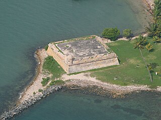
Fortín San Juan de la Cruz, most commonly known as El Cañuelo, was built on Isla de Cabras in the Palo Seco barrio of the municipality of Toa Baja, at the western end of the entrance to San Juan Bay, in Puerto Rico. The square coastal fort has massive sandstone walls that date back to the 1630s. Although the U.S. Navy bombarded the fort in 1898, the fort survived. Today the fort is part of the San Juan National Historic Site, which is listed as a UNESCO World Heritage Site and on both the National Register of Historic Places and the Puerto Rico Register of Historic Sites and Zones. The fort is not open to visitors, but it can be viewed from its exterior.

Miramar is one of the forty subbarrios of Santurce, San Juan, Puerto Rico. The neighborhood has many historic Spanish Revival-style homes with patios and gardens, and it was listed on the Puerto Rico Register of Historic Sites and Zones in 2007 for its historical and architectural value.
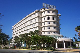
The Normandie Hotel is a historic building located in the Isleta de San Juan, in San Juan, Puerto Rico which opened on October 10, 1942 as a hotel. Its design was inspired by the French transatlantic passenger ship SS Normandie in addition to featuring the same Art Deco design as the ocean liner that inspired it, and the hotel's original roof sign was one of the two signs that adorned the top deck of the SS Normandie but were removed from it during an early refitting. It is an example of what came to be known as the Streamline Moderne architecture style.

Puerta de Tierra is a subbarrio (subdistrict) occupying the eastern portion of the Islet of San Juan and the barrio of San Juan Antiguo in the municipality of San Juan, Puerto Rico. The name Puerta de Tierra derives from the former eastern gated entrance to the walled city of San Juan where Plaza Colón is today. With a population of 2,924 as of 2010, this is the most populated area of San Juan Antiguo. On October 15, 2019, it was added to the National Register of Historic Places.
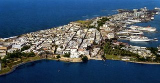
San Juan Islet is a 3-square-mile (7.8 km2) islet or small island on San Juan Bay in the Atlantic coast of northern Puerto Rico. Home to Old San Juan, it is the site of the oldest permanent European settlement in Puerto Rico (1521), and the second oldest European settlement in the West Indies after Santo Domingo (1496). Due to its strategic location in the Caribbean during the Spanish colonization of the Americas, it is home to a city wall and a number of militaristic buildings such as El Morro Castle. Today, it is also home to many of Puerto Rico's government buildings such as the territory's capitol building.

Cape San Juan Light is a historic lighthouse located on the northeastern part of the highest point of Cape San Juan in Fajardo, Puerto Rico. The lighthouse was constructed in 1880 and was officially lit on May 2, 1882. The original illuminating apparatus, not changed until after 1898, had an 18-mile (29 km) range and displayed a fixed white light which every three minutes flashed red.

Punta Tuna Light is a historic lighthouse located in the southeast of the town of Maunabo, Puerto Rico on a narrow promontory at the southeasternmost point of the island.
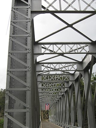
Manatí Bridge at Mata de Plátano, also known as Puente Juan José Jiménez and listed as Bridge #321 in Puerto Rico's bridge inventory, was built in 1905 in Hato Viejo, Ciales, Puerto Rico. It was listed on the National Register of Historic Places in 1995 and on the Puerto Rico Register of Historic Sites and Zones in 2001.

The Jose V. Toledo Federal Building and United States Courthouse is a historic post office and courthouse located at Old San Juan, Puerto Rico. It is a courthouse for the United States District Court for the District of Puerto Rico. It is also the site for oral argument before the United States Court of Appeals for the First Circuit, when that court sits in Puerto Rico.

The School of Tropical Medicine, was an educational institution created in 1926 by an act of the Puerto Rican Legislature, to further the research initiated by the Anemia Commissions and the Institute of Tropical Medicine on anemia and its causes. The institution existed as an independent entity until 1949, when it was integrated into the School of Medicine of the University of Puerto Rico.
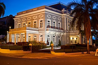
The Antiguo Casino de Puerto Rico, located at Avenida Ponce de León 1 in San Juan, Puerto Rico, is a Beaux Arts architecture style building dating from 1917. It was listed on the National Register of Historic Places in 1977, and on the Puerto Rico Register of Historic Sites and Zones in 2000.

The Puerto Rico National Library is the national library of Puerto Rico. It was created in 1967 as the Biblioteca General de Puerto Rico by Joint Resolution No. 44 of the Puerto Rico Legislature. It opened on April 11, 1973. In 2003 it was renamed Biblioteca Nacional de Puerto Rico by Act 188 of August 17 of that year. The library is ascribed to the Institute of Puerto Rican Culture.
The following is a timeline of the history of the municipality of San Juan, Puerto Rico.

The Polvorín de Miraflores is an 18th-century structure in San Juan, Puerto Rico, specifically in the Isla Grande sector of Santurce, that served as an ammunition storage place for the Spanish military. The site was included in the National Register of Historic Places in 1984 and on the Puerto Rico Register of Historic Sites and Zones in 2000 for its historic importance.

The Biblioteca Carnegie on Avenida Juan Ponce de León in Puerta de Tierra, San Juan, Puerto Rico is a NRHP-listed Carnegie library funded through a $100,000 donation from the Carnegie Foundation, becoming Puerto Rico's first purpose-built library when it was completed in 1915.

The Advanced Defense Line is a historic district consisting of four structures that formed part of the eastern defensive system of the Islet of San Juan in San Juan, Puerto Rico.

The Walls of Old San Juan is a defensive city wall that surrounds the western end of the San Juan Islet, site of the historic district of San Juan, Puerto Rico. This defensive wall system was built between the 16th and 18th centuries to protect the city and the Bay of San Juan, a highly strategic point in the Caribbean. These walls, along with the defensive fortresses in Old San Juan, form part of the UNESCO World Heritage Site-designated San Juan National Historic Site as they are characteristic examples of the historic methods of construction used in military architecture which adapted European designs and techniques to the special conditions of the Caribbean port cities.
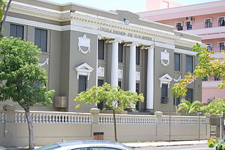
The José Celso Barbosa Graded School is a historic school building located in the Puerta de Tierra historic district in the city of San Juan, Puerto Rico. The school is named after Puerto Rico statehood movement founder Dr. José Celso Barbosa and has been listed in the National Register of Historic Places since 1989, and on the Puerto Rico Register of Historic Sites and Zones since 2000. The school was built between 1924 and 1927 and designed by the firm del Valle & Co. in a Neoclassical-style with the intention of making it a public secondary school for recently graduated students from the nearby Brambaugh School. It forms part of the monumental sequence of buildings and memorials that contribute to the Puerta de Tierra Historic District, which also includes the Capitol of Puerto Rico.


