Mercado | |
|---|---|
 Kiosk in Mercado, San Juan Antiguo | |
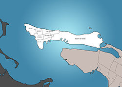 Mercado is in San Juan Antiguo | |
 San Juan Antiguo is in San Juan | |
 Mercado San Juan is in Puerto Rico | |
| Coordinates: 18°28′10″N66°07′03″W / 18.4694956°N 66.1174290°W | |
| Commonwealth | |
| Municipality | |
| Barrio | San Juan Antiguo |
Mercado is one of 7 subbarrios of the San Juan Antiguo barrio in the municipality of San Juan in Puerto Rico. Mercado (Spanish for 'marketplace) is named after Old San Juan's main marketplace, which used to be located there. [1] It is one of the six subbarrios which form part of the Old San Juan Historic District. [2]
Contents
- History
- Demographics
- Cityscape
- Places of interest
- Main streets and squares
- See also
- References
- External links
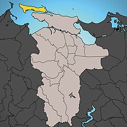
Half of La Perla is located within the borders of the Mercado subbarrio, the other half is located in the neighboring subbarrio, San Cristóbal. [3]