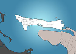
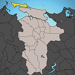
Catedral, Old San Juan

Last updated
Catedral
Vista desde Calle del Cristo y Calle del Tetuan en Catedral subbarrio, Barrio San Juan Antiguo, San Juan, Puerto Rico.jpg
View from Calle del Cristo and Calle del Tetuán in Catedral
San Juan Antiguo Sub Barrios.jpg
Catedral is in San Juan Antiguo
San Juan Antiguo.jpg
San Juan Antiguo is in San Juan
Caribbean location map.svg
Red pog.svg
Catedral
San Juan is in Puerto Rico
Coordinates: 18°27′52″N66°07′09″W / 18.4645589°N 66.1191550°W / 18.4645589; -66.1191550
Commonwealth Flag of Puerto Rico.svg Puerto Rico
Municipality Flag of San Juan, Puerto Rico.svg San Juan
Barrio San Juan Antiguo

Catedral is one of 7 subbarrios of the San Juan Antiguo barrio in the municipality of San Juan in Puerto Rico. Catedral, named after the Cathedral of San Juan Bautista, is one of the six subbarrios which form part of the Old San Juan Historic District. [1]

Contents

History

Having been inhabited since 1511, the Catedral subbarrio represents the oldest portion of Old San Juan, with its namesake cathedral and some of its squares being the oldest established structures in the city. [2] Some of the oldest institutions in the Americas were established here during the 16th century. [3] [4] Additionally, La Fortaleza, the headquarters of the executive branch of the Puerto Rican government, [5] and the Puerto Rico Department of State, [6] are also located in this subbarrio. Originally known as the Barrio de San Juan before the annexation of Santurce and the subsequent dissolution of the previously-established barrios of the city, Catedral still functions as the administrative and historic downtown of the city, containing the cathedral, the city hall and its primary plaza or main town square. [7] [8]

Puerto Rico was ceded by Spain in the aftermath of the Spanish–American War under the terms of the Treaty of Paris of 1898 and became an unincorporated territory of the United States. In 1899, the United States Department of War conducted a census of Puerto Rico finding that the population of Catedral was 2,497. [9]

Cityscape

Places of interest

Main streets and squares

References

  1. "Puerto Rico", Oxford Art Online . Retrieved May 24, 2017
  2. Matovina, Timothy (March 4, 2016). "American Latino Theme Study: Religion (U.S. National Park Service)". NPS.gov Homepage (U.S. National Park Service). Retrieved July 30, 2019.
  3. "Hispanic Firsts", By; Nicolas Kanellos, publisher Visible Ink Press; ISBN   0-7876-0519-0; p.40
  4. Felices Sanchez, Fernando Benicio (2005). "Iglesia de San José". Revista del Instituto de Cultura Puertorriqueña Segunda serie, Año 6 número 11. 2005. San Juan, Puerto Rico: Instituto de Cultura Puertorriqueña. pp. 10–19. Retrieved August 7, 2023.
  5. "La Fortaleza | Oficina del Gobernador". www.fortaleza.pr.gov (in Spanish). Retrieved 2024-08-28.
  6. "Origen del Departamento de Estado | Departamento de Estado" (in Spanish). Retrieved 2021-08-24.
  7. "Puerto Rico", Oxford Art Online . Retrieved May 24, 2017
  8. José A. Mari Mut (2013-08-28). Los pueblos de Puerto Rico y las iglesias de sus plazas.
  9. Joseph Prentiss Sanger; Henry Gannett; Walter Francis Willcox (1900). Informe sobre el censo de Puerto Rico, 1899, United States. War Dept. Porto Rico Census Office (in Spanish). Imprenta del gobierno. p.  162.