| Walls of Old San Juan | |
|---|---|
| Murallas del Viejo San Juan | |
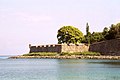
 Western wall from Paseo de la Princesa towards Castillo San Felipe del Morro | |
 Location in Puerto Rico. | |
| Location | Old San Juan, San Juan, Puerto Rico |
| Coordinates | 18°28′3″N66°6′37″W / 18.46750°N 66.11028°W |
| Governing body | National Park Service |
| Criteria | Cultural: (vi) |
| Designated | 1983 (7th session) |
| Part of | La Fortaleza and San Juan National Historic Site in Puerto Rico |
| Reference no. | 266bis-001 |
| Extensions | 2016 |
| Designated | October 15, 1966 |
| Reference no. | 66000930 [1] |
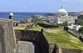
The Walls of Old San Juan (Spanish: Murallas del Viejo San Juan) is a defensive city wall that surrounds the western end of the San Juan Islet, site of the historic district of San Juan, Puerto Rico. This defensive wall system was built between the 16th and 18th centuries to protect the city and the Bay of San Juan, a highly strategic point in the Caribbean. These walls, along with the defensive fortresses in Old San Juan (La Fortaleza, El Morro and San Cristóbal), form part of the UNESCO World Heritage Site-designated San Juan National Historic Site as they are characteristic examples of the historic methods of construction used in military architecture which adapted European designs and techniques to the special conditions of the Caribbean port cities. [2]
Contents
- Overview
- Layout and components
- Southeastern wall and Puerta de Tierra
- Northern wall
- Western wall and Puerta de Agua
- Southern wall
- Gallery
- See also
- References
San Juan remains the only walled city under the United States jurisdiction, with walled cities like Boston, Charleston and New Orleans no longer having walls after the 18th century, although St. Augustine, Florida, still retains several wall remnants. [3] [4] [5] Examples of other North American walled cities that retain their ramparts are Quebec City in Canada and Campeche in Mexico. [6] [7] The bartizans (garitas) found along the walls are considered emblematic of the city of San Juan and a symbol of historic heritage preservation in Puerto Rico. [8] [9]