Transportation in Puerto Rico includes a system of roads, highways, freeways, airports, ports and harbors, and railway systems, serving a population of approximately 4 million year-round. It is funded primarily with both local and federal government funds.
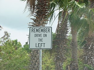
The United States Virgin Islands (USVI) is the only place under United States jurisdiction where the rule of the road is to drive on the left. However, virtually all passenger vehicles are left hand drive due to imports of U.S. vehicles.

San Juan is the capital city and most populous municipality in the Commonwealth of Puerto Rico, an unincorporated territory of the United States. As of the 2020 census, it is the 57th-largest city under the jurisdiction of the United States, with a population of 342,259. San Juan was founded by Spanish colonists in 1521, who called it Ciudad de Puerto Rico.

Luis Muñoz Marín International Airport (LMM), previously known as the Isla Verde International Airport, is the primary international airport of Puerto Rico serving the capital municipality of San Juan and its metropolitan area. Covering 1,600 acres, SJU is located in the beach-front district of Isla Verde in the municipality of Carolina. Named after Luis Muñoz Marín, the first elected governor of the archipelago and island, it is, as of 2023, the 39th busiest airport by passenger boarding, 28th by international passenger traffic, and 24th by cargo throughput within the United States. With 12,197,553 million passengers in 2023, SJU is the busiest airport in the Caribbean, where it serves as a major gateway into the region.
Cataño is a town and municipality on the northeastern coastal plain of Puerto Rico. It is located west of the capital San Juan, east of Toa Baja, north of Bayamón and Guaynabo, and south of San Juan Bay. Part of the San Juan metropolitan area, Cataño is spread over 7 barrios and the downtown area and administrative center of Cataño Pueblo. It is the smallest municipality of Puerto Rico by land area.

Fernando Luis Ribas Dominicci Airport, also commonly known as Isla Grande Airport, is an airport in Isla Grande, a district in the municipality of San Juan, Puerto Rico. It is owned by the Puerto Rico Ports Authority and is adjacent to the Puerto Rico Convention Center, the San Juan Bay, and the Pan American Cruise Ship Terminal, and overlooks Cataño. While Isla Grande's main activity is general aviation, it is still a commercial airport, handling domestic and international commercial flights.

Miramar is one of the forty subbarrios of Santurce, San Juan, Puerto Rico. The neighborhood has many historic Spanish Revival-style homes with patios and gardens, and it was listed on the Puerto Rico Register of Historic Sites and Zones in 2007 for its historical and architectural value.

The Cataño Ferry is a single-route ferry service between Cataño and San Juan, Puerto Rico. The ferry is an icon in Puerto Rican culture.

The Port of Boston is a major seaport located in Boston Harbor and adjacent to the City of Boston. It is the largest port in Massachusetts and one of the principal ports on the East Coast of the United States.

A passenger terminal is a structure in a port which services passengers boarding and leaving water vessels such as ferries, cruise ships and ocean liners. Depending on the types of vessels serviced by the terminal, it may be named ferry terminal, cruise terminal, marine terminal or maritime passenger terminal. As well as passengers, a passenger terminal sometimes has facilities for automobiles and other land vehicles to be picked up and dropped off by the water vessel.
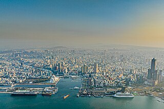
The Port of Kaohsiung is the largest harbor in Taiwan, handling approximately 10.26 million twenty-foot equivalent units (TEU) worth of cargo in 2015. The port is located in southern Taiwan, adjacent to Kaohsiung City, and surrounded by the city districts of Gushan, Yancheng, Lingya, Cianjhen, Siaogang, as well as Cijin. It is operated by Taiwan International Ports Corporation, Taiwan's state-owned harbor management company.

The Rafael Cordero Santiago Port of the Americas —Spanish: Puerto de las Américas Rafael Cordero Santiago (PLA)— is a megaport currently under construction in Ponce, Puerto Rico. The project aims to convert the current Port of Ponce into a value-added tax-free customs-free international shipping hub similar to, though not as large as, the megaports located in Singapore and Rotterdam. The Port of the Americas is Puerto Rico's main Caribbean port, and, at a depth of 50 feet, it is also the deepest port in the Caribbean.

The Port Chiapas or Puerto Madero is a port in Puerto de San Benito in the Tapachula municipality of the Soconusco region in the southern portion of the Mexican state of Chiapas. The port entrance lies about 13 kilometres (8.1 mi) northwest of the mouth of the Suchiate River which is the international boundary between Mexico and Guatemala. Puerto de San Benito is connected by Highway 225 to Tapachula International Airport and the city of Tapachula. Since its opening in 1975 the port has been a small fishing and agricultural transport center. Upgrades carried out in 2005 and since by the government have added facilities for cruise ships and more heavy cargo. Governor Pablo Salazar Mendiguchía had put interest in the original rustic and old port, and later Governor Juan Sabines Guerrero has ordered development of the true port in the hopes it will attract business to Chiapas, the poorest state in Mexico. Ships of the Holland America Line, Regent Seven Seas Cruises, Norwegian Cruise Line, Oceania Cruises and Princess Cruise Line stop at Port Chiapas.

The Port of Mayagüez, located northwest of downtown Mayagüez in Mayagüez Bay, is the third busiest port on Puerto Rico. The port is situated along Puerto Rico routes 64, 341, and 3341, and stretches for 3.8 miles along the coast. Its main canal is 0.4 miles wide and its depth ranges from 47 to 120 feet; the water's depth along the piers ranges between 28 and 29 feet. The port is protected from rough seas by reefs which run along its northern and western sections.

El Port of Puerto Plata is found in San Felipe de Puerto Plata, in Dominican Republic. This is the main port on the north coast and is currently used for cargo operations. In December 2021, the new Taino Bay tourist and cargo terminal was inaugurated.

Isla Grande is one of 40 subbarrios of Barrio Santurce, in San Juan, Puerto Rico.
AcuaExpreso is a ferry service between Cataño and San Juan, Puerto Rico that consists of two routes:

San Juan Bay is the bay and main inlet adjacent to Old San Juan in northeastern Puerto Rico. It is about 3.5 miles (5.6 km) in length, the largest body of water in an estuary of about 97 square miles (250 km2) of channels, inlets and eight interconnected lagoons. The San Juan Bay is home to the island's busiest harbor and its history dates back to at least 1508.

Bahía de Ponce is a bay in Barrio Playa, Ponce, Puerto Rico. The Bay is home to the most important commercial harbor on the Puerto Rico south coast and the second largest in Puerto Rico. The Cardona Island Light is located on the Bay to mark the way into the Bay from the nearby Caja de Muertos Light.


