Puerto Rico Highway 184

Last updated

PR secondary 184.svg

Highway 184

Ruta 184
Route information
Maintained by Puerto Rico DTPW
Length33.4 km [1]  (20.8 mi)
Existed1953 [2] –present
Major junctions
South endPR secondary 3.svg PR-3 in Cacao Bajo
Major intersections
North endPR secondary 1.svg PR-1 in Beatriz
Location
Country United States
Territory Puerto Rico
Municipalities Patillas, Guayama, Cayey, Cidra
Highway system
PR urban primary 183.svg PR-183 PR secondary 185.svg PR-185

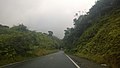
Puerto Rico Highway 184 (PR-184) is a main, rural highway that connects Patillas to Cayey, Puerto Rico, with plans to be extended to Cidra. It extends from PR-3 in Cacao Bajo to PR-1 in Beatriz. [3] [4]

Contents

Route description

Sometimes referred to as Pork Highway, it is the main and only access to the various famous roasted-pork restaurants (lechoneras) in the area of Guavate [5] [6] and the access to the Carite State Forest. It borders the Guavate or Carite River, where several people swim often, and like Puerto Rico Highway 181, it borders the man-made Carite Lake, and it meets its end at Puerto Rico Highway 3. The main antennas of the local TV stations Telemundo, WAPA-TV and Univision can be seen from this road in La Santa. The road passes near a point where five municipalities share a border – Cayey, Patillas, San Lorenzo, Caguas and Guayama. [3] [4]

Major intersections

MunicipalityLocationkm [1] miDestinationsNotes
Patillas Cacao Bajo 0.00.0PR secondary 3.svg PR-3  Patillas, Arroyo Southern terminus of PR-184
1.10.68Ellipse sign 755.svg PR-755  Ancones
Cacao Alto 2.4–
2.5
1.5–
1.6
Ellipse sign 799.svg PR-799  Patillas
Mulas 7.04.3Ellipse sign 754.svg PR-754  Mulas
Quebrada Arriba 9.96.2Ellipse sign 762.svg PR-762  Quebrada Arriba
Muñoz Rivera 19.312.0Ellipse sign 7740.svg PR-7740 (Ruta Panorámica) San Lorenzo Southern terminus of the Ruta Panorámica concurrency
Guayama
No major junctions
Cayey Guavate 24.215.0Ellipse sign 179.svg PR-179 (Ruta Panorámica) Guayama Northern terminus of the Ruta Panorámica concurrency
27.5–
27.6
17.1–
17.1
PR-7184  Guavate Unsigned
27.8–
27.9
17.3–
17.3
Ellipse sign 763.svg PR-763  Caguas
30.819.1Ellipse sign 743.svg PR-743  Vegas
Beatriz 32.520.2Ellipse sign 7736.svg PR-7736  Beatriz
33.1–
33.2
20.6–
20.6
PR primary 52.svg PR-52 (Autopista Luis A. Ferré) Caguas, San Juan, Ponce PR-52 exit 32; diamond interchange
Cidra Beatriz 33.420.8PR secondary 1.svg PR-1  Cayey, Cidra, Caguas Northern terminus of PR-184
1.000 mi = 1.609 km; 1.000 km = 0.621 mi

See also

Related Research Articles

<span class="mw-page-title-main">Puerto Rico Highway 52</span> Highway in Puerto Rico

Puerto Rico Highway 52 (PR-52), a major toll road in Puerto Rico, is also known as Autopista Luis A. Ferré. It was formerly called Expreso Las Américas. It runs from PR-1 in southwest Río Piedras and heads south until it intersects with highway PR-2 in Ponce. At its north end, the short PR-18 continues north from PR-52 towards San Juan. This short segment is known as Expreso Las Américas, the only segment of the route still unofficially bearing this name, since PR-18 is officially named Roberto Sánchez Vilella Expressway. The combined route of PR-18 and PR-52 runs concurrent with the unsigned Interstate Highway PRI-1. Toll stations are located in San Juan, Caguas, Salinas, Juana Díaz, and Ponce.

<span class="mw-page-title-main">Puerto Rico Highway 3</span> Highway in Puerto Rico

Puerto Rico Highway 3(PR-3) at nearly 100 miles long, is the second-longest highway on Puerto Rico. It connects the San Juan neighborhood of Río Piedras to downtown Salinas indirectly around the eastern coast of the island. Highway 3 ranges from a three lane urban avenue in San Juan to a one lane rural road past Fajardo. While other roads connect San Juan, it runs the coastline of Puerto Rico east of San Juan, beginning in Río Piedras near Santurce and goes to Fajardo where it goes south paralleling the coastline to Humacao and Maunabo. It goes up to a mountain-scenic route and goes west to Salinas, where it meets PR-1.

<span class="mw-page-title-main">Puerto Rico Highway 1</span> Highway in Puerto Rico

Puerto Rico Highway 1 (PR-1) is a highway in Puerto Rico that connects the city of Ponce to San Juan. Leaving Ponce, the road heads east and follows a somewhat parallel route along the southern coast of the island heading towards Salinas. At Salinas, the road turns north to cut through the Cordillera Central in its approach to San Juan. Before reaching San Juan, it climbs to make its way to the mountain town of Cayey and then it winds down into the city of Caguas on its final approach to San Juan.

<span class="mw-page-title-main">Puerto Rico Highway 53</span> Highway in Puerto Rico

Puerto Rico Highway 53 (PR-53) or unsigned Interstate PR3 is a main tollway that is parallel to Puerto Rico Highway 3, which goes from Fajardo to Salinas. Some segments are still in planning, but when finished it will be about 58 miles (93 km) in length. Two tunnels, about 0.6 mi (1 km) long each, in the towns of Yabucoa and Maunabo were completed in October 2008. It will connect the cities of Fajardo, Ceiba, Naguabo, Humacao, Yabucoa, Maunabo, Patillas, Arroyo, Guayama and Salinas, thus bordering the entire eastern and southeastern coasts of Puerto Rico. Its northern terminus is at PR-3 and PR-194 in Fajardo, and its south terminus is at PR-52 in Salinas.

<span class="mw-page-title-main">Puerto Rico Highway 413</span> Highway in Puerto Rico

Puerto Rico Highway 413 (PR-413) is a rural road located at the west point of Rincón, Puerto Rico, and is famous in the island for being the main access to beaches near Tres Palmas and the Rincón Lighthouse, where local and international surfing tournaments take place. It is named the Road to Happiness. This highway begins near PR-115 in downtown Rincón, near the west end of Barrio Ensenada. Then it passes trhough Barrio Puntas and ends at PR-115, near the south end of Barrio Río Grande, heading to Aguada, Puerto Rico.

<span class="mw-page-title-main">Puerto Rico Highway 116</span> Highway in Puerto Rico

Puerto Rico Highway 116 (PR-116) is a main highway in the southwest part of Puerto Rico, beginning in Guánica, Puerto Rico at Puerto Rico Highway 2 to Lajas, Puerto Rico at Puerto Rico Highway 101.

<span class="mw-page-title-main">Puerto Rico Highway 181</span> Highway in Puerto Rico

Puerto Rico Highway 181 (PR-181), also known as Expreso Trujillo Alto, is a road that connects the towns of San Juan, Puerto Rico in the north/northeast coast of Puerto Rico with Patillas in the southeast, passing through the municipalities of San Juan at Jesus de Piñero Avenue (PR-17) as it approaches the Teodoro Moscoso Bridge and the Luis Muñoz Marín International Airport, Trujillo Alto, Gurabo, San Lorenzo, Yabucoa and Patillas in the center of the town district near PR-3. Along with PR-10, PR-149, PR-1 and PR-52, it is one of the longest highways crossing the island from north to south through the central mountainous region. In the north part of Trujillo Alto it is a four-lane highway, turning completely rural on the way to Patillas with the exception of a small tract in Gurabo where it intersects PR-30.

<span class="mw-page-title-main">Puerto Rico Highway 15</span> Highway in Puerto Rico

Puerto Rico Highway 15 (PR-15) is a main highway connecting Cayey and Guayama. It takes longer though, than going south to Salinas through PR-52 and taking PR-53 to Guayama, due to it being a rural road.

<span class="mw-page-title-main">Puerto Rico Highway 189</span> Highway in Puerto Rico

Puerto Rico Highway 189 (PR-189) is a 15 kilometres (9 mi) long main highway which parallels very closely the first half of Puerto Rico Highway 30 from Caguas, Puerto Rico near downtown to Juncos, Puerto Rico passing through all three business centers of Caguas, Gurabo and Juncos. It ends at Puerto Rico Highway 31, and has no direct intersection with Puerto Rico Highway 198 although they are not separated by more than half a kilometer.

The Ruta Panorámica, officially the Ruta Panorámica Luis Muñoz Marín, is a 167-mile (269 km) network of some 40 secondary roads which traverse the island of Puerto Rico from west to east along its Cordillera Central. Most of the route consists of three roads, PR-105, PR-143, and PR-182. The route starts in Mayagüez and ends in Maunabo. The first major segment of the route runs from Mayagüez to Maricao as Route 105, then from Adjuntas to Aibonito as Route 143, and then follows Route 182 toward Maunabo.

<span class="mw-page-title-main">Puerto Rico Highway 139</span> Highway in Puerto Rico

Puerto Rico Highway 139 (PR-139) is a two-way secondary highway in the municipality of Ponce, Puerto Rico.

<span class="mw-page-title-main">Puerto Rico Highway 182</span> Highway in Puerto Rico

Puerto Rico Highway 182 (PR-182) is a primary road located entirely within the municipality of Yabucoa, Puerto Rico. The road has its northern terminus at its intersection with Puerto Rico Highway 181 in the northwestern end of the town, near San Lorenzo, and its southern terminus in downtown Yabucoa, near PR-9910 and PR-3, where it provides access to many municipal government offices.

<span class="mw-page-title-main">Guavate, Cayey, Puerto Rico</span> Barrio of Cayey, Puerto Rico

Guavate is a barrio in the municipality of Cayey, Puerto Rico. Its population in 2010 was 1,870.

<span class="mw-page-title-main">Puerto Rico Highway 735</span> Highway in Puerto Rico

Puerto Rico Highway 735 (PR-735) is a rural road located between the municipalities of Cayey and Cidra, Puerto Rico, and it corresponds to an original segment of the historic Carretera Central. The Arenas and La Liendre old bridges are located on this route.

<span class="mw-page-title-main">Puerto Rico Highway 715</span> Highway in Puerto Rico

Puerto Rico Highway 715 (PR-715) is a rural road located in Cayey, Puerto Rico. This highway extends from PR-1 between Matón Arriba and Sumido barrios to Cercadillo.

<span class="mw-page-title-main">Puerto Rico Highway 722</span> Highway in Puerto Rico

Puerto Rico Highway 722 (PR-722) is a rural road located in Aibonito, Puerto Rico. It begins at its intersection with PR-14 east of downtown Aibonito and ends at the Ruta Panorámica between Robles and Pasto barrios. The traditional Festival de las Flores is celebrated near this road.

<span class="mw-page-title-main">Puerto Rico Highway 179</span> Highway in Puerto Rico

Puerto Rico Highway 179 (PR-179) is a rural road that travels from Guayama to Cayey in Puerto Rico. It goes through Patillas but with no major junctions. This road extends from PR-15 north of downtown Guayama and ends at PR-184 in Farallón.

<span class="mw-page-title-main">Puerto Rico Highway 171</span> Highway in Puerto Rico

Puerto Rico Highway 171 (PR-171) is a road that travels from Cidra, Puerto Rico to Cayey. It begins at its intersection with PR-172 in downtown Cidra and ends at its junction with PR-14 near downtown Cayey.

<span class="mw-page-title-main">Puerto Rico Highway 170</span> Highway in Puerto Rico

Puerto Rico Highway 170 (PR-170) is a road located in Cayey, Puerto Rico. This highway begins at its intersection with PR-14 and PR-731 in downtown Cayey and ends at its junction with PR-1 and PR-206 in Matón Arriba.

<span class="mw-page-title-main">Carite State Forest</span> Forest in southeastern Puerto Rico

Carite State Forest is a state forest and nature reserve located in the Sierra de Cayey mountain range in southeastern Puerto Rico. The forest extends over approximately 6,500 acres and is located in the municipalities of Caguas, Cayey, Guayama, Patillas and San Lorenzo. The forest is located along the Ruta Panorámica, which offers access to the forest.

References

  1. 1 2 Google (6 March 2020). "PR-184" (Map). Google Maps . Google. Retrieved 6 March 2020.
  2. "Cayey, Memoria Núm. 42" (PDF). Puerto Rico Planning Board (in Spanish). 1955. Retrieved 4 August 2020.
  3. 1 2 National Geographic Maps (2011). Puerto Rico (Map). 1:125,000. Adventure Map (Book 3107). Evergreen, Colorado: National Geographic Maps. ISBN   978-1566955188. OCLC   756511572.
  4. 1 2 "Tránsito Promedio Diario (AADT)". Transit Data (Datos de Transito) (in Spanish). DTOP PR. pp. 97–98. Archived from the original on 1 April 2019.
  5. "Puerto Rico Leisure Guide – 2021". Issuu. Retrieved 22 January 2022.
  6. Evans, Pat (16 January 2019). "Puerto Rico's Pork Highway is a Meat Lover's Dream". The Manual. Retrieved 22 January 2022.