Cacao Alto

Last updated
Cacao Alto
Barrio
Cacao Alto, Patillas, Puerto Rico locator map.png
Location of Cacao Alto within the municipality of Patillas shown in red
Caribbean location map.svg
Red pog.svg
Cacao Alto
Location of Puerto Rico
Coordinates: 18°00′53″N66°01′40″W / 18.014857°N 66.0277°W / 18.014857; -66.0277 [1]
Commonwealth Flag of Puerto Rico.svg  Puerto Rico
Municipality Flag of Patillas.svg Patillas
Area
[1]
  Total1.23 sq mi (3.2 km2)
  Land1.11 sq mi (2.9 km2)
  Water0.12 sq mi (0.3 km2)
Elevation
[2]
118 ft (36 m)
Population
 (2010)
  Total2,449
  Density2,206.3/sq mi (851.9/km2)
 Source: 2010 Census
Time zone UTC−4 (AST)

Cacao Alto is a barrio in the municipality of Patillas, Puerto Rico. Its population in 2010 was 2,449. [3] [4] [5]

Contents

History

Cacao Alto was in Spain's gazetteers [6] until Puerto Rico was ceded by Spain in the aftermath of the Spanish–American War under the terms of the Treaty of Paris of 1898 and became an unincorporated territory of the United States. In 1899, the United States Department of War conducted a census of Puerto Rico finding that the combined population of Jagual and Cacao Alto barrios was 1,018. [7]

Historical population
CensusPop.Note
1910 481
1920 327−32.0%
1930 46542.2%
1940 57122.8%
1950 1,09491.6%
1960 1,059−3.2%
1980 1,252
1990 1,3457.4%
2000 1,56616.4%
2010 2,44956.4%
U.S. Decennial Census
1900 (N/A) [8] 1910-1930 [9]
1930-1950 [10] 1980-2000 [11] 2010 [12]

See also

Related Research Articles

<span class="mw-page-title-main">Jagual, Patillas, Puerto Rico</span> Barrio of Puerto Rico

Jagual is a barrio in the municipality of Patillas, Puerto Rico. Its population in 2010 was 363.

<span class="mw-page-title-main">Mamey, Patillas, Puerto Rico</span> Barrio of Puerto Rico

Mamey is a barrio in the municipality of Patillas, Puerto Rico. Its population in 2010 was 1,380.

<span class="mw-page-title-main">Apeadero</span> Barrio of Patillas, Puerto Rico

Apeadero is a barrio in the municipality of Patillas, Puerto Rico. Its population in 2010 was 699.

<span class="mw-page-title-main">Cacao Bajo</span> Barrio of Patillas, Puerto Rico

Cacao Bajo is a barrio in the municipality of Patillas, Puerto Rico. Its population in 2010 was 1,437.

<span class="mw-page-title-main">Egozcue</span> Barrio of Patillas, Puerto Rico

Egozcue is a barrio in the municipality of Patillas, Puerto Rico. Its population in 2010 was 52.

<span class="mw-page-title-main">Guardarraya</span> Barrio of Patillas, Puerto Rico

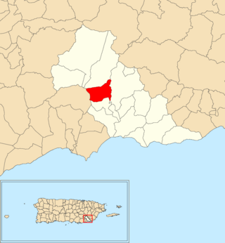
Guardarraya is a barrio in the municipality of Patillas, Puerto Rico. Its population in 2010 was 1,603.

<span class="mw-page-title-main">Jacaboa</span> Barrio of Patillas, Puerto Rico

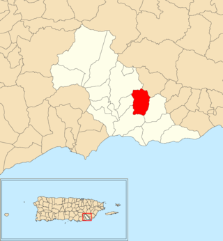
Jacaboa is a barrio in the municipality of Patillas, Puerto Rico. Its population in 2010 was 1,278.

<span class="mw-page-title-main">Quebrada Arriba, Patillas, Puerto Rico</span> Barrio of Puerto Rico

Quebrada Arriba is a barrio in the municipality of Patillas, Puerto Rico. Its population in 2010 was 711.

<span class="mw-page-title-main">Marín, Patillas, Puerto Rico</span> Barrio of Puerto Rico

Marín is a barrio in the municipality of Patillas, Puerto Rico. Its population in 2010 was 890.

<span class="mw-page-title-main">Mulas</span> Barrio of Patillas, Puerto Rico

Mulas is a barrio in the municipality of Patillas, Puerto Rico. Its population in 2010 was 439.

<span class="mw-page-title-main">Ríos, Patillas, Puerto Rico</span> Barrio of Puerto Rico

Ríos is a barrio in the municipality of Patillas, Puerto Rico. Its population in 2010 was 348.

<span class="mw-page-title-main">Bajo, Patillas, Puerto Rico</span> Barrio of Puerto Rico

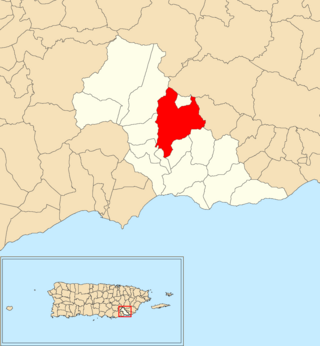
Bajo also spelled Bajos is a barrio in the municipality of Patillas, Puerto Rico. Its population in 2010 was 1,530.

<span class="mw-page-title-main">Galateo Alto</span> Barrio of Isabela, Puerto Rico

Galateo Alto is a barrio in the municipality of Isabela, Puerto Rico. Its population in 2010 was 1,314.

<span class="mw-page-title-main">Cacao, Carolina, Puerto Rico</span> Barrio of Puerto Rico

Cacao is a barrio in the municipality of Carolina, Puerto Rico. Its population in 2010 was 4,214.

<span class="mw-page-title-main">Arenales Altos</span> Barrio of Isabela, Puerto Rico

Arenales Altos is a barrio in the municipality of Isabela, Puerto Rico. Its population in 2010 was 4,101.

<span class="mw-page-title-main">Caín Alto</span> Barrio of San Germán, Puerto Rico

Caín Alto is a barrio in the municipality of San Germán, Puerto Rico. Its population in 2010 was 2,830.

<span class="mw-page-title-main">Rosario Alto</span> Barrio of San Germán, Puerto Rico

Rosario Alto is a barrio in the municipality of San Germán, Puerto Rico. Its population in 2010 was 721.

<span class="mw-page-title-main">Jájome Alto, Cayey, Puerto Rico</span> Barrio of Puerto Rico

Jájome Alto is a barrio in the municipality of Cayey, Puerto Rico. Its population in 2010 was 641.

<span class="mw-page-title-main">Duey Alto, San Germán, Puerto Rico</span> Barrio of Puerto Rico

Duey Alto is a barrio in the municipality of San Germán, Puerto Rico. Its population in 2010 was 1,350.

<span class="mw-page-title-main">Almácigo Alto</span> Barrio of Yauco, Puerto Rico

Almácigo Alto is a barrio in the municipality of Yauco, Puerto Rico. Its population in 2010 was 1,659.

References

  1. 1 2 "US Gazetteer 2019". US Census. US Government.
  2. U.S. Geological Survey Geographic Names Information System: Cacao Alto barrio
  3. Picó, Rafael; Buitrago de Santiago, Zayda; Berrios, Hector H. Nueva geografía de Puerto Rico: física, económica, y social, por Rafael Picó. Con la colaboración de Zayda Buitrago de Santiago y Héctor H. Berrios. San Juan Editorial Universitaria, Universidad de Puerto Rico,1969.
  4. Gwillim Law (20 May 2015). Administrative Subdivisions of Countries: A Comprehensive World Reference, 1900 through 1998. McFarland. p. 300. ISBN   978-1-4766-0447-3 . Retrieved 25 December 2018.
  5. Puerto Rico: 2010 Population and Housing Unit Counts.pdf (PDF). U.S. Dept. of Commerce, Economics and Statistics Administration, U.S. Census Bureau. 2010.
  6. "Anuario del comercio, de la industria, de la magistratura y de la administración. 1881". Biblioteca Nacional de España (in Spanish). p. 1614. Retrieved 4 April 2023.
  7. Joseph Prentiss Sanger; Henry Gannett; Walter Francis Willcox (1900). Informe sobre el censo de Puerto Rico, 1899, United States. War Dept. Porto Rico Census Office (in Spanish). Imprenta del gobierno. p.  163.
  8. "Report of the Census of Porto Rico 1899". War Department Office Director Census of Porto Rico. Archived from the original on July 16, 2017. Retrieved September 21, 2017.
  9. "Table 3-Population of Municipalities: 1930 1920 and 1910" (PDF). United States Census Bureau. Archived (PDF) from the original on August 17, 2017. Retrieved September 21, 2017.
  10. "Table 4-Area and Population of Municipalities Urban and Rural: 1930 to 1950" (PDF). United States Census Bureau. Archived (PDF) from the original on August 30, 2015. Retrieved September 21, 2014.
  11. "Table 2 Population and Housing Units: 1960 to 2000" (PDF). United States Census Bureau. Archived (PDF) from the original on July 24, 2017. Retrieved September 21, 2017.
  12. Puerto Rico: 2010 Population and Housing Unit Counts.pdf (PDF). U.S. Dept. of Commerce Economics and Statistics Administration U.S. Census Bureau. 2010. Archived (PDF) from the original on 2017-02-20. Retrieved 2019-08-02.