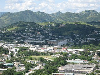
Cayey, officially Cayey de Muesas, is a mountain town and municipality in central Puerto Rico located on the Sierra de Cayey within the Central Mountain range, north of Salinas and Guayama; south of Cidra and Caguas; east of Aibonito and Salinas; and west of San Lorenzo. Cayey is spread over 21 barrios plus Cayey Pueblo. It is part of the San Juan-Caguas-Guaynabo Metropolitan Statistical Area.

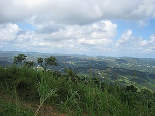
Adjuntas is a small mountainside town and municipality in Puerto Rico located central midwestern portion of the island on the Cordillera Central, north of Yauco, Guayanilla, and Peñuelas; southeast of Utuado; east of Lares and Yauco; and northwest of Ponce. Adjuntas is spread over 16 barrios and Adjuntas Pueblo. Adjuntas is about two hours by car westward from the capital, San Juan.
Cidra is a town and municipality of Puerto Rico located in the central region of the island, north of Cayey; south of Comerío and Aguas Buenas; east of Aibonito and Barranquitas; and west of Caguas. Cidra is spread over 12 barrios and Cidra Pueblo. It is part of the San Juan-Caguas-Guaynabo Metropolitan Statistical Area.

Patillas is a beach town and municipality of Puerto Rico located in the southeastern coast, south of San Lorenzo; west of Yabucoa and Maunabo; and east of Guayama and Arroyo. It is spread over 15 barrios and Patillas Pueblo. It is part of the Guayama Metropolitan Statistical Area.

Trujillo Alto is a town and municipality of Puerto Rico located in the Northern Coastal Plain, on the boundary between the karst zone and Sierra de Luquillo, north of Caguas, and Gurabo; southeast of San Juan, and west of Carolina. Trujillo Alto is part of the San Juan Metropolitan Area, which includes the municipalities of Bayamón, Guaynabo, Cataño, and Toa Baja. The city is spread over 6 barrios and Trujillo Alto Pueblo. It is part of the San Juan-Caguas-Guaynabo Metropolitan Statistical Area.

Utuado is a town and municipality of Puerto Rico located in the central mountainous region of the island known as the Cordillera Central. It is located north of Adjuntas and Ponce; south of Hatillo and Arecibo; east of Lares; and west of Ciales and Jayuya. It is the third-largest municipality in land area in Puerto Rico. According to the 2020 US Census, the municipality has a population of 28,287 spread over 24 barrios and Utuado pueblo.

Villalba, originally known as Villa Alba, is town and municipality of Puerto Rico located in the central region, northeast of Juana Díaz; south of Orocovis; and west of Coamo. Villalba is spread over 6 barrios and Villalba Pueblo. It is part of the Ponce Metropolitan Statistical Area.

Guayama, officially the Autonomous Municipality of Guayama, is a city and municipality on the Caribbean coast of Puerto Rico. As of the 2020 U.S. Census, the city had a population of 36,614. It is the center of the Guayama metropolitan area with a population of 68,442 in 2020.

The La Plata River is the longest river in Puerto Rico. It is located in the north coast of the island. It flows from south to north, and drains into the Atlantic Ocean about 11 miles (18 km) west of San Juan. The mouth of the river is a resort area with white sandy beaches.
Dos Bocas Lake is a lake located in the municipalities of Arecibo and Utuado on the island of Puerto Rico. The lake was created from 1937 until it was completed in 1942 with the construction of the Dos Bocas Dam, by the Puerto Rico Electric Power Authority for a hydroelectric power plant. The building of the dam was a New Deal project. It also serves as one of the island's potable water reservoirs. In recent years, silt has accumulated in the lake causing capacity to shrink. Silt has also made some portions of the land inaccessible by boat.

Guajataca River is a river in Lares, Puerto Rico. It is located on the northwest coast of the island. It flows from the south and drains into the Atlantic Ocean. The name was given by the original Taino inhabitants prior to the arrival of Christopher Columbus.

The Rio Grande de Loíza is a river in the island of Puerto Rico. It is the largest river in Puerto Rico by discharge volume. It is situated on the north coast of the island. It flows from south to north and drains into the Atlantic Ocean, a few miles east of San Juan.

Guajataca Lake, or Lago Guajataca, is a reservoir of the Guajataca River created by the Puerto Rico Electric Power Authority in 1929. It is located between the municipalities of San Sebastián, Quebradillas, and Isabela in Puerto Rico, and receives most of its water from the Rio Guajataca and Rio Chiquito de Cibao rivers. The lake primarily functions as a water reservoir as well as for recreational activities such as boating and fishing. Various species of fish such as peacock bass, largemouth bass, sunfish, perch, catfish, tilapia and threadfin shad can be found in the lake. The Guajataka Scout Reservation partially borders the southern portion of the lake. The dam at Guajataca Lake experienced a structural failure on September 22, 2017, due to the hit from Hurricane Maria.

Lago La Plata is a lake located between the municipalities of Naranjito, Toa Alta, and Bayamón in Puerto Rico. The lake was created in 1973 and serves as a reservoir for potable water.

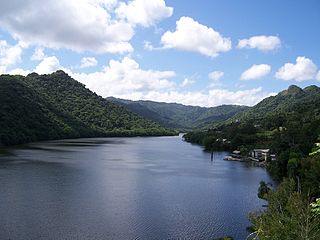
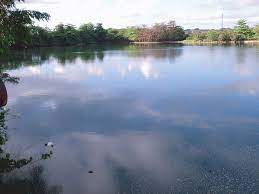
Loíza Lake, or Lago Loíza, is a reservoir located in the municipality of Trujillo Alto, Puerto Rico. It was formed by construction of the Carraízo Dam on the Río Grande de Loíza. It serves as the main water supply source of the San Juan metropolitan area.

Lake Cerrillos is a human-made lake located in barrio Maragüez, Ponce, Puerto Rico. The lake was finished in 1992 by the U.S. Army Corps of Engineers. The main purposes of the reservoir are flood control, water supply, and recreation. There is a variety of fish available for fishing such as largemouth bass, bluegills, catfish and tilapias. The 1993 Central American and Caribbean Games that were held in Ponce staged the canoeing competitions in this lake. It was used in the 2010 Central American and Caribbean Games for the sports of Canoeing, Rowing. The lake is the main drinking water source for the city of Ponce.
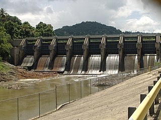
Carraízo Dam is a concrete gravity dam located in the municipality of Trujillo Alto, Puerto Rico within the flow of the Río Grande de Loíza. Its construction was completed in 1953. Carraízo Dam impounds Loíza Lake which serves as Puerto Rico's main water reservoir.
Guerrero is a rural barrio in the municipality of Aguadilla, Puerto Rico. Its population in 2010 was 3,406. In Guerrero barrio is Rafael Hernández, a comunidad.
Carraízo is a barrio in the municipality of Trujillo Alto, Puerto Rico. Its population in 2010 was 16,399.