Playa, Santa Isabel, Puerto Rico

Last updated
Playa
Barrio
2022bahiarinconsantaisabel1.jpg
Rincón Bay in Playa
Playa, Santa Isabel, Puerto Rico locator map.png
Location of Playa within the municipality of Santa Isabel shown in red
Caribbean location map.svg
Red pog.svg
Playa
Location of Puerto Rico
Coordinates: 17°57′13″N66°24′20″W / 17.953618°N 66.405682°W / 17.953618; -66.405682 [1]
Commonwealth Flag of Puerto Rico.svg  Puerto Rico
Municipality Flag of Santa Isabel.svg Santa Isabel
Area
[1]
  Total1.28 sq mi (3.3 km2)
  Land0.58 sq mi (1.5 km2)
  Water0.70 sq mi (1.8 km2)
Elevation
[2]
10 ft (3 m)
Population
 (2010)
  Total807
  Density1,391.4/sq mi (537.2/km2)
 Source: 2010 Census
Time zone UTC−4 (AST)

Playa Barrio is a barrio in the municipality of Santa Isabel, Puerto Rico. Its population in 2010 was 807. [3] [4] [5]

Contents

History

The barrio was in Spain's gazetteers [6] until Puerto Rico was ceded by Spain in the aftermath of the Spanish–American War under the terms of the Treaty of Paris of 1898 and became an unincorporated territory of the United States. In 1899, the United States Department of War conducted a census of Puerto Rico finding that the combined population of Playa and Santa Isabel barrio-pueblo barrios was 1,142. [7]

Historical population
CensusPop.Note
1910 200
1920 34070.0%
1930 52253.5%
1940 72538.9%
1950 586−19.2%
1960 544−7.2%
1980 993
1990 767−22.8%
2000 8409.5%
2010 807−3.9%
U.S. Decennial Census
1900 (N/A) [8] 1910-1930 [9]
1930-1950 [10] 1980-2000 [11] 2010 [12]

See also

Related Research Articles

<span class="mw-page-title-main">Buena Vista, Bayamón, Puerto Rico</span> Barrio of Puerto Rico

Buena Vista is a barrio in the municipality of Bayamón, Puerto Rico. Its population in 2010 was 15,518.

<span class="mw-page-title-main">Cañabón, Caguas, Puerto Rico</span> Barrio of Puerto Rico

Cañabón is a barrio in the municipality of Caguas, Puerto Rico. Its population in 2010 was 11,310.

<span class="mw-page-title-main">Sabana Yeguas</span> Barrio of Lajas, Puerto Rico

Sabana Yeguas is a barrio in the municipality of Lajas, Puerto Rico. Its population in 2010 was 2,082.

<span class="mw-page-title-main">Macaná, Peñuelas, Puerto Rico</span> Barrio of Puerto Rico

Macaná is a barrio in the municipality of Peñuelas, Puerto Rico. Its population in 2010 was 803.

<span class="mw-page-title-main">Río Cañas, Añasco, Puerto Rico</span> Barrio of Puerto Rico

Río Cañas is a barrio in the municipality of Añasco, Puerto Rico. Its population in 2010 was 300.

<span class="mw-page-title-main">Bajura, Isabela, Puerto Rico</span> Barrio of Puerto Rico

Bajura is a barrio in the municipality of Isabela, Puerto Rico. Its population in 2010 was 663.

<span class="mw-page-title-main">Playa, Guayanilla, Puerto Rico</span> Barrio of Puerto Rico

Playa Barrio is a rural barrio in the municipality of Guayanilla, Puerto Rico. Its population in 2010 was 1,186.

<span class="mw-page-title-main">Tierras Nuevas Poniente</span> Barrio of Manatí, Puerto Rico

Tierras Nuevas Poniente is a rural barrio in the municipality of Manatí, Puerto Rico. Its population in 2010 was 3,614.

<span class="mw-page-title-main">Rosario, Mayagüez, Puerto Rico</span> Barrio of Puerto Rico

Rosario is a barrio in the municipality of San German, Puerto Rico. Its population in 2010 was 1403.

<span class="mw-page-title-main">Cuebas</span> Barrio of Peñuelas, Puerto Rico

Cuebas is a barrio in the municipality of Peñuelas, Puerto Rico. Its population in 2010 was 449.

<span class="mw-page-title-main">Paso Palma</span> Barrio of Utuado, Puerto Rico

Paso Palma is a barrio in the municipality of Utuado, Puerto Rico. Its population in 2010 was 582.

<span class="mw-page-title-main">Felicia 1</span> Barrio of Santa Isabel, Puerto Rico

Felicia 1 is a barrio in the municipality of Santa Isabel, Puerto Rico. Its population in 2010 was 530.

<span class="mw-page-title-main">Carrizales, Hatillo, Puerto Rico</span> Barrio of Puerto Rico

Carrizales is a rural, coastal barrio in the municipality of Hatillo, Puerto Rico. Its population in 2010 was 8,066.

<span class="mw-page-title-main">Rincón, Cayey, Puerto Rico</span> Barrio of Puerto Rico

Rincón is a barrio in the municipality of Cayey, Puerto Rico. Its population in 2010 was 6,764.

<span class="mw-page-title-main">Minillas, San Germán, Puerto Rico</span> Barrio of Puerto Rico

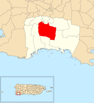
Minillas is a barrio in the municipality of San Germán, Puerto Rico. Its population in 2010 was 3,377.

<span class="mw-page-title-main">Guamaní</span> Barrio of Guayama, Puerto Rico

Guamaní is a barrio in the municipality of Guayama, Puerto Rico. Its population in 2010 was 1,455.

<span class="mw-page-title-main">Machuchal, Sabana Grande, Puerto Rico</span> Barrio of Puerto Rico

Machuchal is a barrio in the municipality of Sabana Grande, Puerto Rico. Its population in 2010 was 4,773.

<span class="mw-page-title-main">Rayo, Sabana Grande, Puerto Rico</span> Barrio of Puerto Rico

Rayo is a barrio in the municipality of Sabana Grande, Puerto Rico. Its population in 2010 was 3,084.

<span class="mw-page-title-main">Cintrona</span> Barrio of Juana Díaz, Puerto Rico

Cintrona is a barrio in the municipality of Juana Díaz, Puerto Rico. Its population in 2010 was 3,226.

<span class="mw-page-title-main">Sierra Alta</span> Barrio of Yauco, Puerto Rico

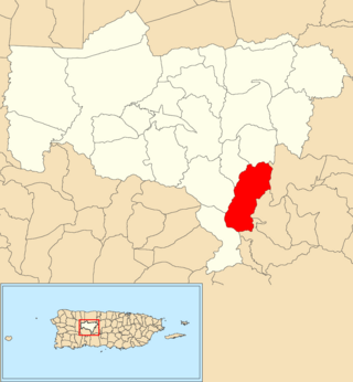
Sierra Alta is a barrio in the municipality of Yauco, Puerto Rico. Its population in 2010 was 1,063.

References

  1. 1 2 "US Gazetteer 2019". US Census. US Government.
  2. U.S. Geological Survey Geographic Names Information System: Playa barrio
  3. Picó, Rafael; Buitrago de Santiago, Zayda; Berrios, Hector H. Nueva geografía de Puerto Rico: física, económica, y social, por Rafael Picó. Con la colaboración de Zayda Buitrago de Santiago y Héctor H. Berrios. San Juan Editorial Universitaria, Universidad de Puerto Rico,1969.
  4. Gwillim Law (20 May 2015). Administrative Subdivisions of Countries: A Comprehensive World Reference, 1900 through 1998. McFarland. p. 300. ISBN   978-1-4766-0447-3 . Retrieved 25 December 2018.
  5. Puerto Rico: 2010 Population and Housing Unit Counts.pdf (PDF). Dept. of Commerce, Economics and Statistics Administration, Census Bureau. 2010.
  6. "Anuario del comercio, de la industria, de la magistratura y de la administración. 1881". Biblioteca Nacional de España (in Spanish). p. 1614. Retrieved 4 April 2023.
  7. Joseph Prentiss Sanger; Henry Gannett; Walter Francis Willcox (1900). Informe sobre el censo de Puerto Rico, 1899, United States. War Dept. Porto Rico Census Office (in Spanish). Imprenta del gobierno. p.  165.
  8. "Report of the Census of Porto Rico 1899". War Department Office Director Census of Porto Rico. Archived from the original on July 16, 2017. Retrieved September 21, 2017.
  9. "Table 3-Population of Municipalities: 1930 1920 and 1910" (PDF). United States Census Bureau. Archived (PDF) from the original on August 17, 2017. Retrieved September 21, 2017.
  10. "Table 4-Area and Population of Municipalities Urban and Rural: 1930 to 1950" (PDF). United States Census Bureau. Archived (PDF) from the original on August 30, 2015. Retrieved September 21, 2014.
  11. "Table 2 Population and Housing Units: 1960 to 2000" (PDF). United States Census Bureau. Archived (PDF) from the original on July 24, 2017. Retrieved September 21, 2017.
  12. Puerto Rico: 2010 Population and Housing Unit Counts.pdf (PDF). U.S. Dept. of Commerce Economics and Statistics Administration U.S. Census Bureau. 2010. Archived (PDF) from the original on 2017-02-20. Retrieved 2019-08-02.