San Juan is the capital city and most populous municipality in the Commonwealth of Puerto Rico, an unincorporated territory of the United States. As of the 2020 census, it is the 57th-largest city under the jurisdiction of the United States, with a population of 342,259. San Juan was founded by Spanish colonists in 1521, who called it Ciudad de Puerto Rico.

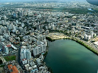
Hato Rey is a former barrio located in the northwest part of the dissolved municipality of Río Piedras. It now stretches over three barrios of the municipality of San Juan, Puerto Rico: Hato Rey Norte, Hato Rey Central, and Hato Rey Sur.
Santurce is a barrio of San Juan. Its population in 2020 was 69,469. It is also the biggest and most populated of all the barrios in the capital city with a bigger population than most municipalities of Puerto Rico and one of the most densely populated areas of the island .
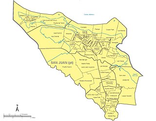
The municipality of San Juan is divided into 18 barrios, 16 of which fall within the former municipality of Río Piedras. Eight of the barrios are further divided into subbarrios, and they include the two barrios that originally composed the municipality of San Juan :

Puerto Rico Highway 23 (PR-23), also known as Franklin Delano Roosevelt Avenue along its entire length, is a main highway in San Juan, Puerto Rico. It begins at the interchange of PR-2 and PR-165 near San Patricio in Guaynabo and goes east to the Milla de Oro business area, passing through Plaza Las Américas and ending at Barbosa Avenue (PR-27) junction in eastern Hato Rey.

Gobernador Piñero is one of the 18 barrios of the municipality of San Juan, Puerto Rico. With a population of 44,006 (2010) living in a land area of 4.44 square miles (11.5 km2), it is San Juan’s second most populated barrio after Santurce, and the fourth largest in land area.

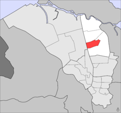
Hato Rey Central is one of the 18 barrios of the municipality of San Juan, Puerto Rico. With a population density of 16,155.3 per square mile. It has a land area of 1.03 sq mi and a 2010 Census population of 16,640.

Hato Rey Sur is one of the 18 barrios of the municipality of San Juan, Puerto Rico. Hato Rey Sur was a barrio of the former municipality of Rio Piedras, before it was merged with the municipality of San Juan in 1951. Following the annexation of Rio Piedras, the city of San Juan, and its surrounding area now including Rio Piedras, quadrupled its former size.
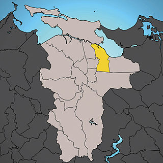
Oriente is one of the 18 barrios of the municipality of San Juan, Puerto Rico. It is composed of 3 subbarrios: Borinquen, López Sicardó, and San José. Before 1951, it was a barrio of the former municipality of Rio Piedras. In 2010, it had a population of 31,374. It is surrounded by the barrios of Sabana Llana Norte to the east, Sabana Llana Sur to the south, Hato Rey Central and Hato Rey Norte to the west, and Santurce barrio and the San Jose Lagoon to the north.
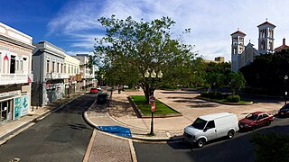
Río Piedras Pueblo, is one of 18 barrios in the municipality of San Juan, Puerto Rico. Rio Piedras Pueblo is what used to be the urban center-barrio of the former municipality of Río Piedras until 1951, when the municipality of Rio Piedras was merged with the municipality of San Juan.

Minillas is one of the 40 subbarrios of Santurce, in the municipality of San Juan, Puerto Rico.

Martín Peña is one of the 4 subbarrios of barrio Hato Rey Norte, in the municipality of San Juan, Puerto Rico. The subbarrio has more than 2000 informal houses which get flooded with waters of the Martín Peña Channel.

Quintana is a subbarrio, a legal subdivision of Hato Rey Central, a barrio in San Juan, Puerto Rico.

Las Monjas is a subbarrio, a legal subdivision of Hato Rey Central, a barrio in San Juan, Puerto Rico.
Ciudad Nueva is a subbarrio, a legal subdivision of Hato Rey Central, a barrio in San Juan, Puerto Rico.

Santa Rita is one of the 4 subbarrios of Hato Rey Sur, itself one of 18 barrios of the municipality of San Juan, Puerto Rico.
Hyde Park is one of the 4 subbarrios of Hato Rey Sur, itself one of 18 barrios of the municipality of San Juan, Puerto Rico.

Hato Rey Norte is one of the 18 barrios of the municipality of San Juan, Puerto Rico. Hato Rey Norte was part of the former municipality of Rio Piedras, before it was merged with the municipality of San Juan in 1951.