Bayola | |
|---|---|
 A building on Calle Estrella in Bayola | |
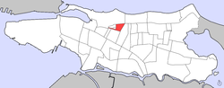 Map of Santurce barrio with Bayola highlighted | |
| Coordinates: 18°27′05″N66°03′58″W / 18.4513086°N 66.0661980°W | |
| Commonwealth | |
| Municipality | |
| Barrio | Santurce |
| Area | |
• Total | .03 sq mi (0.078 km2) |
| • Land | .03 sq mi (0.078 km2) |
| • Water | 0 sq mi (0 km2) |
| Elevation | 10 ft (3.0 m) |
| Population (2010) | |
• Total | 748 |
| • Density | 24,933.3/sq mi (9,626.8/km2) |
| Source: 2010 Census | |
| Time zone | UTC−4 (AST) |
Bayola is one of the forty subbarrios of Santurce, San Juan, Puerto Rico.
Contents
It's located between Expreso Baldorioty de Castro to the south, Calle Wilson to the north, Avenida de Diego to the east and Primavera Street to the west.
Bayola comprises just 4 streets. These are Calle Estrella, Calle Tres Hermanos, Calle Washington and Calle Julian Blanco.
