Corozal barrio-pueblo

Last updated
Corozal barrio-pueblo
Pueblo de Corozal
Municipality Seat [1]
Corozal, 00783, Puerto Rico - panoramio (4).jpg
Main square with the Corozal city hall in the center
Corozal barrio-pueblo, Corozal, Puerto Rico locator map.png
Location of Corozal barrio-pueblo within the municipality of Corozal shown in red
Caribbean location map.svg
Red pog.svg
Corozal barrio-pueblo
Location of Puerto Rico
Coordinates: 18°20′23″N66°19′00″W / 18.3397382°N 66.3167536°W / 18.3397382; -66.3167536 [2]
Commonwealth Flag of Puerto Rico.svg  Puerto Rico
Municipality Corozal.svg Corozal
Area
[2]
  Total.352 sq mi (0.91 km2)
  Land.352 sq mi (0.91 km2)
  Water0 sq mi (0 km2)
Elevation
[3]
262 ft (80 m)
Population
 (2010)
  Total2,631
  Density7,517.1/sq mi (2,902.4/km2)
 Source: 2010 Census
Time zone UTC−4 (AST)

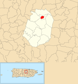
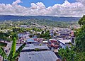
Corozal barrio-pueblo is an urban barrio and the administrative center (seat) of Corozal, a municipality of Puerto Rico. Its population in 2010 was 2,631. [1] [4]

Contents

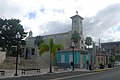
As was customary in Spain, in Puerto Rico, the municipality has a pueblo which contains a central plaza, the municipal buildings (city hall), and a Catholic church. Fiestas patronales (patron saint festivals) are held in the central plaza every year. [5] [6]

History

Corozal barrio-pueblo was in Spain's gazetteers [7] until Puerto Rico was ceded by Spain in the aftermath of the Spanish–American War under the terms of the Treaty of Paris of 1898 and became an unincorporated territory of the United States. In 1899, the United States Department of War conducted a census of Puerto Rico finding that the population of Corozal barrio-pueblo (Pueblo) was 1,057. [8]

Features and demographics

Corozal barrio-pueblo has .352 square miles (0.91 km2) of land area and no water area. In 2010, its population was 2,631 with a population density of 7,517.1 inhabitants per square mile (2,902.4/km2). [9]

Historical population
CensusPop.Note
1900 1,057
1910 1,30123.1%
1920 1,74734.3%
1930 2,45140.3%
1940 2,97421.3%
1950 2,428−18.4%
1960 3,16630.4%
1970 0−100.0%
1980 1,663
1990 3,01181.1%
2000 2,850−5.3%
2010 2,631−7.7%
U.S. Decennial Census
1899 (shown as 1900) [10] 1910-1930 [11]
1930-1950 [12] 1980-2000 [13] 2010 [14]

The central plaza and its church

The central plaza, or square, is a place for official and unofficial recreational events and a place where people can gather and socialize from dusk to dawn. The Laws of the Indies, Spanish law, which regulated life in Puerto Rico in the early 19th century, stated the plaza's purpose was for "the parties" (celebrations, festivities) (Spanish : a propósito para las fiestas), and that the square should be proportionally large enough for the number of neighbors (Spanish : grandeza proporcionada al número de vecinos). These Spanish regulations also stated that the streets nearby should be comfortable portals for passersby, protecting them from the elements: sun and rain. [5]

Located across the central plaza in Corozal barrio-pueblo is the Parroquia La Sagrada Familia, a Roman Catholic church. [15]

Sectors

Barrios (which are, in contemporary times, roughly comparable to minor civil divisions) [16] in turn are further subdivided into smaller local populated place areas/units called sectores (sectors in English). The types of sectores may vary, from normally sector to urbanización to reparto to barriada to residencial, among others. [17] [18] [19]

The following sectors are in Corozal barrio-pueblo: [20]

Barriada Aldea Vázquez, Barriada Bou, Calle Carmelo Aponte, Calle Cervantes, Calle Colegio Católico, Calle Culto, Calle Gándara, Calle Genaro Bou, Calle Howard T. Jason, Calle José Valiente, Calle La Marina, Calle Las Mercedes, Calle Nueva, Calle San Manuel, Calle Urbano Ramírez, Calle Santo Domingo, Calle Sostre, Calle San Ramón, Desvío Urbano, Extensión Sobrino, Residencial El Centro, Residencial Enrique Landrón, Sector Alcantarilla, Sector Alfonso Matos, Sector Cantera, Sector Portugués, Urbanización Sanfeliz, and Urbanización Sobrino.

See also

Related Research Articles

<span class="mw-page-title-main">Guaynabo barrio-pueblo</span> Historical and administrative center (seat) of Guaynabo, Puerto Rico

Guaynabo barrio-pueblo is a barrio and the administrative center (seat) of Guaynabo, a municipality of Puerto Rico. Its population in 2010 was 4,008.

<span class="mw-page-title-main">Cataño barrio-pueblo</span> Historical and administrative center (seat) of Cataño, Puerto Rico

Cataño barrio-pueblo is an urban barrio and the administrative center (seat) of Cataño, a municipality of Puerto Rico. Its population in 2010 was 4,283. It is an urban barrio located in the northeastern section of the municipality.

<span class="mw-page-title-main">Naranjito barrio-pueblo</span> Historical and administrative center (seat) of Naranjito, Puerto Rico

Naranjito barrio-pueblo is a barrio and the administrative center (seat) of Naranjito, a municipality of Puerto Rico. Its population in 2010 was 1,157.

<span class="mw-page-title-main">Pueblo, Corozal, Puerto Rico</span> Barrio of Puerto Rico

Pueblo is an urban barrio in the municipality of Corozal, Puerto Rico. Its population in 2010 was 2,991.

<span class="mw-page-title-main">Aguada barrio-pueblo</span> Historical and administrative center (seat) of Aguada, Puerto Rico

Aguada barrio-pueblo is a small barrio and the administrative center (seat) of Aguada, a municipality of Puerto Rico. Its population in 2010 was 1,324. Aguada barrio-pueblo has two subdivisions: California and Rosario.

<span class="mw-page-title-main">Comerío barrio-pueblo</span> Historical and administrative center (seat) of Comerío, Puerto Rico

Comerío barrio-pueblo is a barrio and the administrative center (seat) of Comerío, a municipality of Puerto Rico. Its population in 2010 was 3,657.

<span class="mw-page-title-main">Ciales barrio-pueblo</span> Historical and administrative center (seat) of Ciales, Puerto Rico

Ciales barrio-pueblo is a barrio and the administrative center (seat) of Ciales, a municipality of Puerto Rico. Its population in 2010 was 1,009.

<span class="mw-page-title-main">San Sebastián barrio-pueblo</span> Historical and administrative center (seat) of San Sebastián, Puerto Rico

San Sebastián barrio-pueblo is a barrio and the administrative center (seat) of San Sebastián, a municipality of Puerto Rico. Its population in 2010 was 1,424.

<span class="mw-page-title-main">Ceiba barrio-pueblo</span> Historical and administrative center (seat) of Ceiba, Puerto Rico

Ceiba barrio-pueblo is a barrio and the administrative center (seat) of Ceiba, a municipality of Puerto Rico. Its population in 2010 was 3,677. As was customary in Spain, in Puerto Rico, the municipality has a barrio called pueblo which contains a central plaza, the municipal buildings, and a Catholic church. Fiestas patronales are held in the central plaza every year.

<span class="mw-page-title-main">Toa Alta barrio-pueblo</span> Historical and administrative center (seat) of Toa Alta, Puerto Rico

Toa Alta barrio-pueblo is a barrio and the administrative center (seat) of Toa Alta, a municipality of Puerto Rico. Its population in 2010 was 397.

<span class="mw-page-title-main">Toa Baja barrio-pueblo</span> Historical and administrative center (seat) of Toa Baja, Puerto Rico

Toa Baja barrio-pueblo is a barrio and the administrative center (seat) of Toa Baja, a municipality of Puerto Rico. Its population in 2010 was 565.

<span class="mw-page-title-main">Villalba barrio-pueblo</span> Historical and administrative center (seat) of Villalba, Puerto Rico

Villalba barrio-pueblo is a barrio and the administrative center (seat) of Villalba, a municipality of Puerto Rico. Its population in 2010 was 729.

<span class="mw-page-title-main">Rincón barrio-pueblo</span> Historical and administrative center (seat) of Rincón, Puerto Rico

Rincón barrio-pueblo is a barrio-pueblo, the administrative center (seat) of Rincón, a municipality of Puerto Rico. Its population in 2010 was 933.

<span class="mw-page-title-main">San Lorenzo barrio-pueblo</span> Historical and administrative center (seat) of San Lorenzo, Puerto Rico

San Lorenzo barrio-pueblo is a barrio and the administrative center (seat) of San Lorenzo, a municipality of Puerto Rico. Its population in 2010 was 2,045.

<span class="mw-page-title-main">Loíza barrio-pueblo</span> Historical and administrative center (seat) of Loíza, Puerto Rico

Loíza barrio-pueblo is a barrio and the administrative center (seat) of Loíza, a municipality of Puerto Rico. Its population in 2010 was 3,875.

<span class="mw-page-title-main">Lares barrio-pueblo</span> Historical and administrative center (seat) of Lares, Puerto Rico

Lares barrio-pueblo is a barrio and the administrative center (seat) of Lares, a municipality of Puerto Rico. Its population in 2010 was 2,690.

<span class="mw-page-title-main">Orocovis barrio-pueblo</span> Historical and administrative center (seat) of Orocovis, Puerto Rico

Barrio Pueblo is a barrio and the administrative center (seat) of Orocovis, a municipality of Puerto Rico. Its population in 2010 was 682.

<span class="mw-page-title-main">Morovis barrio-pueblo</span> Historical and administrative center (seat) of Morovis, Puerto Rico

Morovis barrio-pueblo is a barrio and the administrative center (seat) of Morovis, a municipality of Puerto Rico. Morovis barrio-pueblo has about 12 sectors and its population in 2010 was 895.

<span class="mw-page-title-main">Naguabo barrio-pueblo</span> Historical and administrative center (seat) of Naguabo, Puerto Rico

Naguabo barrio-pueblo is a barrio and the administrative center (seat) of Naguabo, a municipality of Puerto Rico. Its population in 2010 was 1,514.

<span class="mw-page-title-main">Río Grande barrio-pueblo</span> Historical and administrative center (seat) of Río Grande, Puerto Rico

Río Grande barrio-pueblo is a barrio and the administrative center (seat) of Río Grande, a municipality of Puerto Rico. Its population in 2010 was 1,772.

References

  1. 1 2 Puerto Rico: 2010 Population and Housing Unit Counts.pdf (PDF). U.S. Dept. of Commerce, Economics and Statistics Administration, U.S. Census Bureau. 2010.
  2. 1 2 "US Gazetteer 2019". US Census. US Government.
  3. U.S. Geological Survey Geographic Names Information System: Corozal barrio-pueblo
  4. Picó, Rafael; Buitrago de Santiago, Zayda; Berrios, Hector H. Nueva geografía de Puerto Rico: física, económica, y social, por Rafael Picó. Con la colaboración de Zayda Buitrago de Santiago y Héctor H. Berrios (in Spanish). San Juan Editorial Universitaria, Universidad de Puerto Rico,1969.
    - Gwillim Law (20 May 2015). Administrative Subdivisions of Countries: A Comprehensive World Reference, 1900 through 1998. McFarland. p. 300. ISBN   978-1-4766-0447-3 . Retrieved 25 December 2018.
    - "US Census Barrio-Pueblo definition". factfinder.com. US Census. Archived from the original on 13 May 2017. Retrieved 5 January 2019.
  5. 1 2 Santullano, Luis A. (10 March 2019). Mirada al Caribe. Vol. 54. Colegio de Mexico. pp. 75–78. doi:10.2307/j.ctvbcd2vs.12. JSTOR   j.ctvbcd2vs.12.
  6. Pariser, Harry S. (2003). Explore Puerto Rico, Fifth Edition . San Francisco: Manatee Press. pp.  52–55. Retrieved 10 February 2019.
  7. "Anuario del comercio, de la industria, de la magistratura y de la administración. 1881". Biblioteca Nacional de España (in Spanish). p. 1614. Retrieved 4 April 2023.
  8. Joseph Prentiss Sanger; Henry Gannett; Walter Francis Willcox (1900). Informe sobre el censo de Puerto Rico, 1899, United States. War Dept. Porto Rico Census Office (in Spanish). Imprenta del gobierno. p. 161.
  9. Puerto Rico: 2010 population and housing unit counts.pdf (PDF). U.S. Dept. of Commerce, Economics and Statistics Administration, U.S. Census Bureau. 2010.
  10. "Report of the Census of Porto Rico 1899". War Department Office Director Census of Porto Rico. Archived from the original on July 16, 2017. Retrieved September 21, 2017.
  11. "Table 3-Population of Municipalities: 1930 1920 and 1910" (PDF). United States Census Bureau. Archived (PDF) from the original on August 17, 2017. Retrieved September 21, 2017.
  12. "Table 4-Area and Population of Municipalities Urban and Rural: 1930 to 1950" (PDF). United States Census Bureau. Archived (PDF) from the original on August 30, 2015. Retrieved September 21, 2014.
  13. "Table 2 Population and Housing Units: 1960 to 2000" (PDF). United States Census Bureau. Archived (PDF) from the original on July 24, 2017. Retrieved September 21, 2017.
  14. Puerto Rico: 2010 Population and Housing Unit Counts.pdf (PDF). U.S. Dept. of Commerce Economics and Statistics Administration U.S. Census Bureau. 2010. Archived (PDF) from the original on 2017-02-20. Retrieved 2019-08-02.
  15. Mari Mut, José A. (2013-08-28). Los Pueblos de Puerto Rico y Las Iglesias de Sus Plazas [The Pueblos of Puerto Rico, and the Churches of its Plazas] (PDF) (in Spanish). Archived (PDF) from the original on 2020-12-14. Retrieved 2021-09-16.
  16. "US Census Barrio-Pueblo definition". factfinder.com. US Census. Archived from the original on 13 May 2017. Retrieved 5 January 2019.
  17. "Agencia: Oficina del Coordinador General para el Financiamiento Socioeconómico y la Autogestión (Proposed 2016 Budget)". Puerto Rico Budgets (in Spanish). Retrieved 28 June 2019.
  18. Rivera Quintero, Marcia (2014), El vuelo de la esperanza: Proyecto de las Comunidades Especiales Puerto Rico, 1997-2004 (first ed.), San Juan, Puerto Rico Fundación Sila M. Calderón, ISBN   978-0-9820806-1-0
  19. "Leyes del 2001". Lex Juris Puerto Rico (in Spanish). Retrieved 24 June 2020.
  20. "PRECINTO ELECTORAL COROZAL 072" (PDF). Comisión Estatal de Elecciones (in Spanish). PR Government. 21 September 2019. Archived from the original (PDF) on 26 June 2020. Retrieved 24 June 2020.