Egozcue

Last updated
Egozcue
Barrio
Egozcue, Patillas, Puerto Rico locator map.png
Location of Egozcue within the municipality of Patillas shown in red
Caribbean location map.svg
Red pog.svg
Egozcue
Location of Puerto Rico
Coordinates: 18°03′22″N65°59′55″W / 18.056086°N 65.99868°W / 18.056086; -65.99868 [1]
Commonwealth Flag of Puerto Rico.svg  Puerto Rico
Municipality Flag of Patillas.svg Patillas
Area
[1]
  Total0.48 sq mi (1.2 km2)
  Land0.48 sq mi (1.2 km2)
  Water0 sq mi (0 km2)
Elevation
[2]
1,450 ft (440 m)
Population
 (2010)
  Total52
  Density108.3/sq mi (41.8/km2)
 Source: 2010 Census
Time zone UTC−4 (AST)

Egozcue is a barrio in the municipality of Patillas, Puerto Rico. Its population in 2010 was 52. [3] [4] [5]

Contents

Historical population
CensusPop.Note
1910 229
1920 32341.0%
1930 234−27.6%
1940 27718.4%
1950 105−62.1%
1960 1104.8%
1980 141
1990 81−42.6%
2000 52−35.8%
2010 520.0%
U.S. Decennial Census
1900 (N/A) [6] 1910-1930 [7]
1930-1950 [8] 1980-2000 [9] 2010 [10]

Sectors

Barrios (which are, in contemporary times, roughly comparable to minor civil divisions) [11] in turn are further subdivided into smaller local populated place areas/units called sectores (sectors in English). The types of sectores may vary, from normally sector to urbanización to reparto to barriada to residencial, among others. [12] [13] [14]

The following sectors are in Egozcue barrio: [15]

Carretera 181, Carretera 7759, Sector Betancourt, Sector Calanse, Sector Campusu, Sector Cuatro Calles, Sector El Coquí, Sector Guaraguao, Sector Huertas, and Sector Pedragón.

See also

Related Research Articles

<span class="mw-page-title-main">Aibonito, San Sebastián, Puerto Rico</span> Barrio of Puerto Rico

Aibonito is a barrio in the municipality of San Sebastián, Puerto Rico. Its population in 2010 was 1,972.

<span class="mw-page-title-main">Pozas, San Sebastián, Puerto Rico</span> Barrio of Puerto Rico

Pozas is a barrio in the municipality of San Sebastián, Puerto Rico. Its population in 2010 was 3,515.

<span class="mw-page-title-main">Río Grande, Rincón, Puerto Rico</span> Barrio of Puerto Rico

Río Grande is a barrio in the municipality of Rincón, Puerto Rico. Its population in 2010 was 1,187.

<span class="mw-page-title-main">Jagual, Patillas, Puerto Rico</span> Barrio of Puerto Rico

Jagual is a barrio in the municipality of Patillas, Puerto Rico. Its population in 2010 was 363.

<span class="mw-page-title-main">Mamey, Patillas, Puerto Rico</span> Barrio of Puerto Rico

Mamey is a barrio in the municipality of Patillas, Puerto Rico. Its population in 2010 was 1,380.

<span class="mw-page-title-main">Apeadero</span> Barrio of Patillas, Puerto Rico

Apeadero is a barrio in the municipality of Patillas, Puerto Rico. Its population in 2010 was 699.

<span class="mw-page-title-main">Cacao Bajo</span> Barrio of Patillas, Puerto Rico

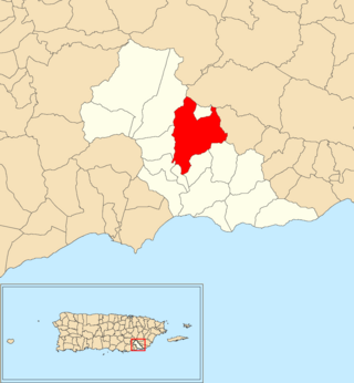
Cacao Bajo is a barrio in the municipality of Patillas, Puerto Rico. Its population in 2010 was 1,437.

<span class="mw-page-title-main">Guardarraya</span> Barrio of Patillas, Puerto Rico

Guardarraya is a barrio in the municipality of Patillas, Puerto Rico. Its population in 2010 was 1,603.

<span class="mw-page-title-main">Jacaboa</span> Barrio of Patillas, Puerto Rico

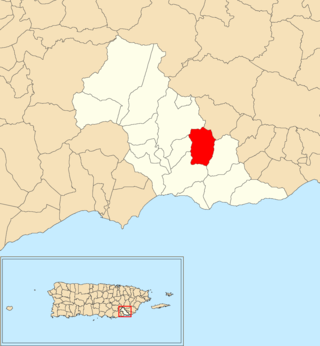
Jacaboa is a barrio in the municipality of Patillas, Puerto Rico. Its population in 2010 was 1,278.

<span class="mw-page-title-main">Quebrada Arriba, Patillas, Puerto Rico</span> Barrio of Puerto Rico

Quebrada Arriba is a barrio in the municipality of Patillas, Puerto Rico. Its population in 2010 was 711.

<span class="mw-page-title-main">Marín, Patillas, Puerto Rico</span> Barrio of Puerto Rico

Marín is a barrio in the municipality of Patillas, Puerto Rico. Its population in 2010 was 890.

<span class="mw-page-title-main">Mulas</span> Barrio of Patillas, Puerto Rico

Mulas is a barrio in the municipality of Patillas, Puerto Rico. Its population in 2010 was 439.

<span class="mw-page-title-main">Muñoz Rivera</span> Barrio of Patillas, Puerto Rico

Muñoz Rivera is a barrio in the municipality of Patillas, Puerto Rico. Its population in 2010 was 673.

<span class="mw-page-title-main">Pollos, Patillas, Puerto Rico</span> Barrio of Puerto Rico

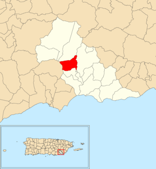
Pollos is a barrio in the municipality of Patillas, Puerto Rico. Its population in 2010 was 3,146.

<span class="mw-page-title-main">Ríos, Patillas, Puerto Rico</span> Barrio of Puerto Rico

Ríos is a barrio in the municipality of Patillas, Puerto Rico. Its population in 2010 was 348.

<span class="mw-page-title-main">Bajo, Patillas, Puerto Rico</span> Barrio of Puerto Rico

Bajo also spelled Bajos is a barrio in the municipality of Patillas, Puerto Rico. Its population in 2010 was 1,530.

<span class="mw-page-title-main">Llanos, Aibonito, Puerto Rico</span> Barrio of Puerto Rico

Llanos is a barrio in the municipality of Aibonito, Puerto Rico. Its population in 2010 was 6,840.

<span class="mw-page-title-main">Guacio</span> Barrio of San Sebastián, Puerto Rico

Guacio is a barrio in the municipality of San Sebastián, Puerto Rico. Its population in 2010 was 640.

<span class="mw-page-title-main">Hoya Mala</span> Barrio of San Sebastián, Puerto Rico

Hoya Mala is a barrio in the municipality of San Sebastián, Puerto Rico. Its population in 2010 was 3,594.

<span class="mw-page-title-main">Piedras Blancas, San Sebastián, Puerto Rico</span> Barrio of Puerto Rico

Piedras Blancas is a barrio in the municipality of San Sebastián, Puerto Rico. Its population in 2010 was 2,563.

References

  1. 1 2 "US Gazetteer 2019". US Census. US Government.
  2. U.S. Geological Survey Geographic Names Information System: Egozcue barrio
  3. Picó, Rafael; Buitrago de Santiago, Zayda; Berrios, Hector H. Nueva geografía de Puerto Rico: física, económica, y social, por Rafael Picó. Con la colaboración de Zayda Buitrago de Santiago y Héctor H. Berrios. San Juan Editorial Universitaria, Universidad de Puerto Rico,1969.
  4. Gwillim Law (20 May 2015). Administrative Subdivisions of Countries: A Comprehensive World Reference, 1900 through 1998. McFarland. p. 300. ISBN   978-1-4766-0447-3 . Retrieved 25 December 2018.
  5. Puerto Rico: 2010 Population and Housing Unit Counts.pdf (PDF). U.S. Dept. of Commerce, Economics and Statistics Administration, U.S. Census Bureau. 2010.
  6. "Report of the Census of Porto Rico 1899". War Department Office Director Census of Porto Rico. Archived from the original on July 16, 2017. Retrieved September 21, 2017.
  7. "Table 3-Population of Municipalities: 1930 1920 and 1910" (PDF). United States Census Bureau. Archived (PDF) from the original on August 17, 2017. Retrieved September 21, 2017.
  8. "Table 4-Area and Population of Municipalities Urban and Rural: 1930 to 1950" (PDF). United States Census Bureau. Archived (PDF) from the original on August 30, 2015. Retrieved September 21, 2014.
  9. "Table 2 Population and Housing Units: 1960 to 2000" (PDF). United States Census Bureau. Archived (PDF) from the original on July 24, 2017. Retrieved September 21, 2017.
  10. Puerto Rico: 2010 Population and Housing Unit Counts.pdf (PDF). U.S. Dept. of Commerce Economics and Statistics Administration U.S. Census Bureau. 2010. Archived (PDF) from the original on 2017-02-20. Retrieved 2019-08-02.
  11. "US Census Barrio-Pueblo definition". factfinder.com. US Census. Archived from the original on 13 May 2017. Retrieved 5 January 2019.
  12. "Agencia: Oficina del Coordinador General para el Financiamiento Socioeconómico y la Autogestión (Proposed 2016 Budget)". Puerto Rico Budgets (in Spanish). Retrieved 28 June 2019.
  13. Rivera Quintero, Marcia (2014), El vuelo de la esperanza: Proyecto de las Comunidades Especiales Puerto Rico, 1997-2004 (first ed.), San Juan, Puerto Rico Fundación Sila M. Calderón, ISBN   978-0-9820806-1-0
  14. "Leyes del 2001". Lex Juris Puerto Rico (in Spanish). Retrieved 24 June 2020.
  15. "PRECINTO ELECTORAL Patillas 091" (PDF). Comisión Estatal de Elecciones (in Spanish). Junta de Planificación - Gobierno de Puerto Rico. 22 September 2020. Retrieved 4 January 2021.