San Isidro, Culebra, Puerto Rico

Last updated
San Isidro
Barrio
Map of Culebra highlighting San Isidro.png
Map of Culebra highlighting San Isidro
USA Puerto Rico location map.svg
Red pog.svg
San Isidro
Coordinates: 18°20′51″N65°14′12″W / 18.347363°N 65.236663°W / 18.347363; -65.236663 [1]
Commonwealth Flag of Puerto Rico.svg  Puerto Rico
Municipality Flag of Culebra (Puerto Rico).svg Culebra
Area
[1]
  Total25.62 sq mi (66.4 km2)
  Land2.26 sq mi (5.9 km2)
  Water23.36 sq mi (60.5 km2)
Elevation
[2]
0 ft (0 m)
Population
 (2010)
  Total16
  Density7.1/sq mi (2.7/km2)
 Source: 2010 Census
Time zone UTC−4 (AST)
ZIP Code
00775

San Isidro is a barrio in the island-municipality of Culebra, Puerto Rico. Its population in 2010 was 16. [3] [4] [5]

Contents

It consists of a part of the island of Culebra in the northeast, and of islands and islets such as Roca Speck, Cayo Norte, Cayo Sombrerito, Cayos Geniquí, Cayo Tiburón, and Cayo Ballena.

Historical population
CensusPop.Note
1930 116
1940 75−35.3%
1950 37−50.7%
1960 7−81.1%
1980 8
1990 18125.0%
2000 2222.2%
2010 16−27.3%
U.S. Decennial Census
1899 (shown as 1900) [6] 1910-1930 [7]
1930-1950 [8] 1980-2000 [9] 2010 [10]

See also

Related Research Articles

<span class="mw-page-title-main">Monacillo Urbano, San Juan, Puerto Rico</span> Barrio of San Juan, Puerto Rico

Monacillo Urbano is one of 18 barrios in the municipality of San Juan, Puerto Rico. The barrio was originally part of Monacillo. In 2010, it had a population of 22,342 living in a land area of 3.23 square miles (8.68 km2). Monacillo Urbano is surrounded by Gobernador Piñero barrio to the north, El Cinco barrio to the east, Monacillo barrio to the south, and the municipality of Guaynabo to the west.

<span class="mw-page-title-main">Oriente, San Juan, Puerto Rico</span> Barrio of Puerto Rico

Oriente is one of the 18 barrios of the municipality of San Juan, Puerto Rico. It is composed of 3 subbarrios: Borinquen, López Sicardó, and San José. Before 1951, it was a barrio of the former municipality of Rio Piedras. In 2010, it had a population of 31,374. It is surrounded by the barrios of Sabana Llana Norte to the east, Sabana Llana Sur to the south, Hato Rey Central and Hato Rey Norte to the west, and Santurce barrio and the San Jose Lagoon to the north.

<span class="mw-page-title-main">Fraile, Culebra, Puerto Rico</span> Barrio of Puerto Rico

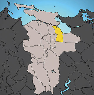
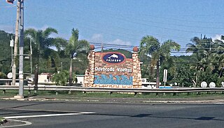
Fraile is a barrio in the island-municipality of Culebra, Puerto Rico. Its population in 2010 was 42.

<span class="mw-page-title-main">Buena Vista, Hatillo, Puerto Rico</span> Barrio of Puerto Rico

Buena Vista is a rural barrio in the municipality of Hatillo, Puerto Rico. Its population in 2010 was 2,490.

<span class="mw-page-title-main">Quebrada Arriba, Cayey, Puerto Rico</span> Barrio of Puerto Rico

Quebrada Arriba is a barrio in the municipality of Cayey, Puerto Rico. Its population in 2010 was 1,451.

<span class="mw-page-title-main">San Ildefonso, Coamo, Puerto Rico</span> Barrio of Puerto Rico

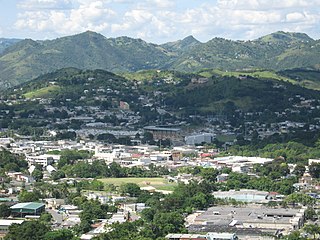
San Ildefonso is a barrio in the municipality of Coamo, Puerto Rico. Its population in 2010 was 11,427.

<span class="mw-page-title-main">Campo Alegre, Hatillo, Puerto Rico</span> Barrio of Puerto Rico

Campo Alegre is a rural barrio in the municipality of Hatillo, Puerto Rico. Its population in 2010 was 5,210.

<span class="mw-page-title-main">Mameyes Arriba</span> Barrio of Jayuya, Puerto Rico

Mameyes Arriba is a barrio in the municipality of Jayuya, Puerto Rico. Its population in 2010 was 2,240.

<span class="mw-page-title-main">Zamas, Jayuya, Puerto Rico</span> Barrio of Puerto Rico

Zamas is a barrio in the municipality of Jayuya, Puerto Rico. Its population in 2010 was 499.

<span class="mw-page-title-main">Flamenco, Culebra, Puerto Rico</span> Barrio of Puerto Rico

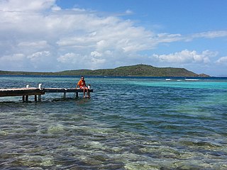
Flamenco is a barrio in the island-municipality of Culebra, Puerto Rico. Its population in 2010 was 1,048.

<span class="mw-page-title-main">Playa Sardinas I</span> Barrio of Culebra, Puerto Rico

Playa Sardinas I is a barrio in the municipality of Culebra, Puerto Rico. Its population in 2010 was 186.

<span class="mw-page-title-main">Playa Sardinas II</span> Barrio of Culebra, Puerto Rico

Playa Sardinas II is a barrio in the municipality of Culebra, Puerto Rico. Its population in 2010 was 64.

<span class="mw-page-title-main">Carenero</span> Barrio of Guánica, Puerto Rico

Carenero is a barrio in the municipality of Guánica, Puerto Rico. Its population in 2010 was 2,670.

<span class="mw-page-title-main">Rubias, Yauco, Puerto Rico</span> Barrio of Puerto Rico

Rubias is a barrio in the municipality of Yauco, Puerto Rico. Its population in 2010 was 309.

<span class="mw-page-title-main">San Salvador, Caguas, Puerto Rico</span> Barrio of Puerto Rico

San Salvador is a barrio in the municipality of Caguas, Puerto Rico. Its population in 2010 was 3,089.

<span class="mw-page-title-main">Culebras Alto, Cayey, Puerto Rico</span> Barrio of Puerto Rico

Culebras Alto is a barrio in the municipality of Cayey, Puerto Rico. Its population in 2010 was 252.

<span class="mw-page-title-main">Culebras Bajo, Cayey, Puerto Rico</span> Barrio of Puerto Rico

Culebras Bajo is a barrio in the municipality of Cayey, Puerto Rico. Its population in 2010 was 238.

<span class="mw-page-title-main">Quebrada Vueltas</span> Barrio of Fajardo, Puerto Rico

Quebrada Vueltas is a barrio in the municipality of Fajardo, Puerto Rico. Its population in 2010 was 3,665.

<span class="mw-page-title-main">Callabo</span> Barrio of Juana Díaz, Puerto Rico

Callabo is a barrio in the municipality of Juana Díaz, Puerto Rico. Its population in 2010 was 2,237.

<span class="mw-page-title-main">Maresúa</span> Barrio of San Germán, Puerto Rico

Maresúa is a barrio in the municipality of San Germán, Puerto Rico. Its population in 2010 was 1,794.

References

  1. 1 2 "US Gazetteer 2019". US Census. US Government.
  2. U.S. Geological Survey Geographic Names Information System: San Isidro barrio
  3. Picó, Rafael; Buitrago de Santiago, Zayda; Berrios, Hector H. Nueva geografía de Puerto Rico: física, económica, y social, por Rafael Picó. Con la colaboración de Zayda Buitrago de Santiago y Héctor H. Berrios. San Juan Editorial Universitaria, Universidad de Puerto Rico,1969.
  4. Gwillim Law (20 May 2015). Administrative Subdivisions of Countries: A Comprehensive World Reference, 1900 through 1998. McFarland. p. 300. ISBN   978-1-4766-0447-3 . Retrieved 25 December 2018.
  5. Puerto Rico: 2010 Population and Housing Unit Counts.pdf (PDF). U.S. Dept. of Commerce, Economics and Statistics Administration, U.S. Census Bureau. 2010.
  6. "Report of the Census of Porto Rico 1899". War Department Office Director Census of Porto Rico. Archived from the original on July 16, 2017. Retrieved September 21, 2017.
  7. "Table 3-Population of Municipalities: 1930 1920 and 1910" (PDF). United States Census Bureau. Archived (PDF) from the original on August 17, 2017. Retrieved September 21, 2017.
  8. "Table 4-Area and Population of Municipalities Urban and Rural: 1930 to 1950" (PDF). United States Census Bureau. Archived (PDF) from the original on August 30, 2015. Retrieved September 21, 2014.
  9. "Table 2 Population and Housing Units: 1960 to 2000" (PDF). United States Census Bureau. Archived (PDF) from the original on July 24, 2017. Retrieved September 21, 2017.
  10. Puerto Rico: 2010 Population and Housing Unit Counts.pdf (PDF). U.S. Dept. of Commerce Economics and Statistics Administration U.S. Census Bureau. 2010. Archived (PDF) from the original on 2017-02-20. Retrieved 2019-08-02.