Mamey | |
|---|---|
Barrio | |
 Mirador Gavillan scenic overlook in Mamey | |
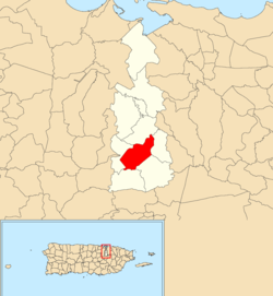 Location of Mamey within the municipality of Guaynabo shown in red | |
 Mamey Location of Puerto Rico | |
| Coordinates: 18°18′54″N66°06′58″W / 18.314936°N 66.115974°W [1] | |
| Commonwealth | |
| Municipality | |
| Area | |
• Total | 2.45 sq mi (6.3 km2) |
| • Land | 2.45 sq mi (6.3 km2) |
| • Water | 0 sq mi (0 km2) |
| Elevation | 607 ft (185 m) |
| Population (2010) | |
• Total | 3,103 |
| • Density | 1,266.5/sq mi (489.0/km2) |
| Source: 2010 Census | |
| Time zone | UTC−4 (AST) |
Mamey is a barrio in the municipality of Guaynabo, Puerto Rico. Its population in 2010 was 3,103. [3] [4] [5]
Contents
| Census | Pop. | Note | %± |
|---|---|---|---|
| 1910 | 940 | — | |
| 1920 | 949 | 1.0% | |
| 1930 | 1,015 | 7.0% | |
| 1940 | 1,307 | 28.8% | |
| 1950 | 1,243 | −4.9% | |
| 1960 | 1,959 | 57.6% | |
| 1970 | 1,690 | −13.7% | |
| 1980 | 2,097 | 24.1% | |
| 1990 | 2,279 | 8.7% | |
| 2000 | 3,165 | 38.9% | |
| 2010 | 3,103 | −2.0% | |
| U.S. Decennial Census 1899 (shown as 1900) [6] 1910-1930 [7] 1930-1950 [8] 1980-2000 [9] 2010 [10] | |||

