Coabey

Last updated
Coabey
Barrio
Cemi Museum in Barrio Coabey, Jayuya.jpg
Cemi Museum in Coabey
Coabey, Jayuya, Puerto Rico locator map.png
Location of Coabey within the municipality of Jayuya shown in red
Caribbean location map.svg
Red pog.svg
Coabey
Location of Puerto Rico
Coordinates: 18°12′51″N66°33′44″W / 18.214119°N 66.56214°W / 18.214119; -66.56214 [1]
Commonwealth Flag of Puerto Rico.svg  Puerto Rico
Municipality Flag of Jayuya.svg Jayuya
Area
[1]
  Total3.81 sq mi (9.9 km2)
  Land3.81 sq mi (9.9 km2)
  Water0.00 sq mi (0.0 km2)
Elevation
[2]
1,880 ft (570 m)
Population
 (2010)
  Total2,166
  Density568.5/sq mi (219.5/km2)
 Source: 2010 Census
Time zone UTC−4 (AST)

Coabey is a barrio in the municipality of Jayuya, Puerto Rico. Its population in 2010 was 2,166. [3] [4] [5] Coabey is a newer barrio which was formed from areas of Jayuya barrio-pueblo and its first census was done in 1930. [6]

Contents

Historical population
CensusPop.Note
1930 680
1940 95941.0%
1950 1,27733.2%
1960 1,118−12.5%
1980 1,286
1990 1,75336.3%
2000 2,06918.0%
2010 2,1664.7%
U.S. Decennial Census
1930 [7]
1930-1950 [8] 1980-2000 [9] 2010 [10]

Features

The El Cemí Museum (Museo El Cemí) is in Coabey, Jayuya. The museum features Taíno history. [11]

The Casa Canales Museum (Museo Casa Canales) is in Coabey. The museum features the events and people surrounding the Jayuya Uprising event in 1950.

See also

Related Research Articles

<span class="mw-page-title-main">Jayuya, Puerto Rico</span> Town and municipality in Puerto Rico

Jayuya is a town and municipality of Puerto Rico located in the mountainous center region of the island, north of Ponce; east of Utuado; and west of Ciales. Jayuya is spread over 10 barrios and Jayuya Pueblo. It is the principal city of the Jayuya Micropolitan Statistical Area.

<span class="mw-page-title-main">Pueblo, San Juan, Puerto Rico</span> Barrio of Puerto Rico

Río Piedras Pueblo, is one of 18 barrios in the municipality of San Juan, Puerto Rico. Rio Piedras Pueblo is what used to be the urban center-barrio of the former municipality of Río Piedras until 1951, when the municipality of Rio Piedras was merged with the municipality of San Juan.

Stella(Stella comunidad) is a community in Pueblo barrio and Calvache barrio, in the municipality of Rincón, Puerto Rico. Its population in 2010 was 1,088.

<span class="mw-page-title-main">Pitahaya, Luquillo, Puerto Rico</span> Barrio of Puerto Rico

Pitahaya is a barrio in the municipality of Luquillo, Puerto Rico. Its population in 2010 was 4,523.

<span class="mw-page-title-main">Río Grande, Jayuya, Puerto Rico</span> Barrio of Puerto Rico

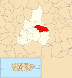
Río Grande is a barrio in the municipality of Jayuya, Puerto Rico. Its population in 2010 was 879.

<span class="mw-page-title-main">Buena Vista, Hatillo, Puerto Rico</span> Barrio of Puerto Rico

Buena Vista is a rural barrio in the municipality of Hatillo, Puerto Rico. Its population in 2010 was 2,490.

<span class="mw-page-title-main">Collores, Jayuya, Puerto Rico</span> Barrio of Puerto Rico

Collores is a barrio in the municipality of Jayuya, Puerto Rico. Its population in 2010 was 1,666. In 1948, Collores was established from part of what was Jayuya Arriba .

<span class="mw-page-title-main">Mameyes Abajo</span> Barrio of Utuado, Puerto Rico

Mameyes Abajo is a barrio in the municipality of Utuado, Puerto Rico. Its population in 2010 was 1,136. The corresponding Mameyes Arriba is located in neighbouring Jayuya at a higher elevation, but was once part of Utuado as well.

<span class="mw-page-title-main">Jauca</span> Barrio of Jayuya, Puerto Rico

Jauca is a barrio in the municipality of Jayuya, Puerto Rico. Its population in 2010 was 116. In 1948, Jauca was established from part of what was Jayuya Arriba .

<span class="mw-page-title-main">Jayuya Abajo</span> Barrio of Jayuya, Puerto Rico

Jayuya Abajo is a barrio in the municipality of Jayuya, Puerto Rico. Its population in 2010 was 3,367.

<span class="mw-page-title-main">Mameyes Arriba</span> Barrio of Jayuya, Puerto Rico

Mameyes Arriba is a barrio in the municipality of Jayuya, Puerto Rico. Its population in 2010 was 2,240.

<span class="mw-page-title-main">Pica, Jayuya, Puerto Rico</span> Barrio of Puerto Rico

Pica is a barrio in the municipality of Jayuya, Puerto Rico. Its population in 2010 was 153. In 1948, Pica was established from part of what was Jayuya Arriba .

<span class="mw-page-title-main">Saliente</span> Barrio in Jayuya, Puerto Rico

Saliente is a barrio in the municipality of Jayuya, Puerto Rico. Its population in 2010 was 649.

<span class="mw-page-title-main">Veguitas, Jayuya, Puerto Rico</span> Barrio of Puerto Rico

Veguitas is a barrio in the municipality of Jayuya, Puerto Rico. Its population in 2010 was 3,685.

<span class="mw-page-title-main">Zamas, Jayuya, Puerto Rico</span> Barrio of Puerto Rico

Zamas is a barrio in the municipality of Jayuya, Puerto Rico. Its population in 2010 was 499.

<span class="mw-page-title-main">Arena, Guánica, Puerto Rico</span> Barrio of Puerto Rico

Arena is a barrio in the municipality of Guánica, Puerto Rico. Its population in 2010 was 96.

<span class="mw-page-title-main">Jayuya barrio-pueblo</span> Historical and administrative center (seat) of Jayuya, Puerto Rico

Jayuya barrio-pueblo is a barrio and the administrative center (seat) of Jayuya, a municipality of Puerto Rico. Its population in 2010 was 1,222.

<span class="mw-page-title-main">Ceiba, Las Piedras, Puerto Rico</span> Barrio of Puerto Rico

Ceiba is a barrio in the municipality of Las Piedras, Puerto Rico. Its population in 2010 was 2,500.

<span class="mw-page-title-main">Guamaní</span> Barrio of Guayama, Puerto Rico

Guamaní is a barrio in the municipality of Guayama, Puerto Rico. Its population in 2010 was 1,455.

<span class="mw-page-title-main">Lajas, Lajas, Puerto Rico</span> Barrio of Puerto Rico

Lajas is a barrio in the municipality of Lajas, Puerto Rico. Its population in 2010 was 2,694.

References

  1. 1 2 "US Gazetteer 2019". US Census. US Government.
  2. U.S. Geological Survey Geographic Names Information System: Coabey Barrio
  3. Picó, Rafael; Buitrago de Santiago, Zayda; Berrios, Hector H. Nueva geografía de Puerto Rico: física, económica, y social, por Rafael Picó. Con la colaboración de Zayda Buitrago de Santiago y Héctor H. Berrios. San Juan Editorial Universitaria, Universidad de Puerto Rico,1969.
  4. Gwillim Law (20 May 2015). Administrative Subdivisions of Countries: A Comprehensive World Reference, 1900 through 1998. McFarland. p. 300. ISBN   978-1-4766-0447-3 . Retrieved 25 December 2018.
  5. Puerto Rico: 2010 Population and Housing Unit Counts.pdf (PDF). U.S. Dept. of Commerce, Economics and Statistics Administration, U.S. Census Bureau. 2010.
  6. Mapa de Municipios y Barrios (PDF). Santurce, Puerto Rico: Junta de Planificación. 1955. p. 25. Retrieved 10 April 2021.
  7. "Table 3-Population of Municipalities: 1930 1920 and 1910" (PDF). United States Census Bureau. Archived (PDF) from the original on August 17, 2017. Retrieved September 21, 2017.
  8. "Table 4-Area and Population of Municipalities Urban and Rural: 1930 to 1950" (PDF). United States Census Bureau. Archived (PDF) from the original on August 30, 2015. Retrieved September 21, 2014.
  9. "Table 2 Population and Housing Units: 1960 to 2000" (PDF). United States Census Bureau. Archived (PDF) from the original on July 24, 2017. Retrieved September 21, 2017.
  10. Puerto Rico: 2010 Population and Housing Unit Counts.pdf (PDF). U.S. Dept. of Commerce Economics and Statistics Administration U.S. Census Bureau. 2010. Archived (PDF) from the original on 2017-02-20. Retrieved 2019-08-02.
  11. "Museo El Cemí". Discover Puerto Rico. Retrieved 2021-09-05.