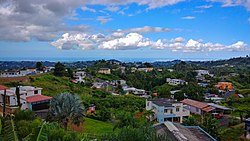
Cedro Arriba

Last updated
Cedro Arriba
Barrio
Barrio Cedro Arriba, Naranjito, Puerto Rico.jpg
Looking north from Cedro Arriba
Cedro Arriba, Naranjito, Puerto Rico locator map.png
Location of Cedro Arriba within the municipality of Naranjito shown in red
Caribbean location map.svg
Red pog.svg
Cedro Arriba
Location of Puerto Rico
Coordinates: 18°15′27″N66°16′50″W / 18.257372°N 66.280577°W / 18.257372; -66.280577 [1]
Commonwealth Flag of Puerto Rico.svg  Puerto Rico
Municipality Flag of Naranjito, Puerto Rico.svg Naranjito
Area
[1]
  Total5.29 sq mi (13.7 km2)
  Land5.29 sq mi (13.7 km2)
  Water0 sq mi (0 km2)
Elevation
[2]
1,722 ft (525 m)
Population
 (2010)
  Total3,876
  Density732.7/sq mi (282.9/km2)
 Source: 2010 Census
Time zone UTC−4 (AST)
Zip code
00719

Cedro Arriba is a barrio in the municipality of Naranjito, Puerto Rico. Its population in 2010 was 3,876. [3] [4] [5]

Contents

History

Cedro Arriba was in Spain's gazetteers [6] until Puerto Rico was ceded by Spain in the aftermath of the Spanish–American War under the terms of the Treaty of Paris of 1898 and became an unincorporated territory of the United States. In 1899, the United States Department of War conducted a census of Puerto Rico finding that the population of Cedro Arriba barrio was 915. [7] Some of the sectors within this barrio receive water service from a private system, and not from Puerto Rico Aqueducts and Sewers Authority. [8]

Historical population
CensusPop.Note
1900 915
1910 686−25.0%
1920 7478.9%
1930 7784.1%
1940 91717.9%
1950 1,29240.9%
1960 1,3433.9%
1980 2,281
1990 2,98731.0%
2000 3,55619.0%
2010 3,8769.0%
U.S. Decennial Census
1899 (shown as 1900) [9] 1910-1930 [10]
1930-1950 [11] 1980-2000 [12] 2010 [13]

Sectors

Barrios (which are, in contemporary times, roughly comparable to minor civil divisions) [14] in turn are further subdivided into smaller local populated place areas/units called sectores (sectors in English). The types of sectores may vary, from normally sector to urbanización to reparto to barriada to residencial, among others. [15] [16] [17]

The following sectors are in Cedro Arriba barrio: [8] [18]

El Abanico, Sector Ángel Avilés, Sector Cabrera, Sector El Banco, Sector El Pueblito, Sector El Riíto, Sector Feijoó Anones, Sector Feijoó Cedro Arriba, Sector Ferrer, Sector La Gallera, Sector La Pajona, Sector Las Cruces, Sector Loncho López, Sector Los López, Sector Los Morales, Sector Los Pomos, Sector Los Ríos, Sector Los Zayas, Sector Maná, Sector Moncho Rodríguez, Sector Peñabert, Sector San Antonio, Sector Sánchez, Sector Santa Rita, Sector Tiñín Ortega, and Sector Xanadú.

See also

Related Research Articles

<span class="mw-page-title-main">Achiote, Naranjito, Puerto Rico</span> Barrio of Puerto Rico

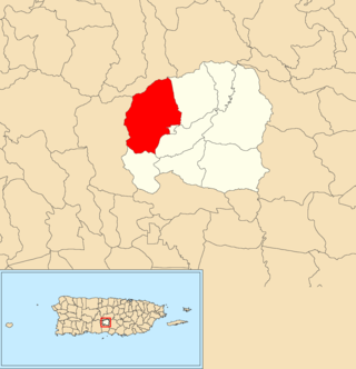
Achiote is a barrio in the municipality of Naranjito, Puerto Rico. Its population in 2010 was 3,919.

<span class="mw-page-title-main">Anones</span> Barrio of Naranjito, Puerto Rico

Anones is a barrio in the municipality of Naranjito, Puerto Rico. Its population in 2010 was 4,976. Anones is located to the South of the urban center of the municipality. There are schools and shops here and it is the most mountainous area of the municipality.

<span class="mw-page-title-main">Cedro Abajo</span> Barrio of Naranjito, Puerto Rico

Cedro Abajo is a barrio in the municipality of Naranjito, Puerto Rico. Its population in 2010 was 4,627.

<span class="mw-page-title-main">Nuevo, Naranjito, Puerto Rico</span> Barrio of Puerto Rico

Nuevo is a barrio in the municipality of Naranjito, Puerto Rico. Its population in 2010 was 4,004.

<span class="mw-page-title-main">Guadiana, Naranjito, Puerto Rico</span> Barrio of Puerto Rico

Guadiana is a barrio in the municipality of Naranjito, Puerto Rico. Its population in 2010 was 3,978.

<span class="mw-page-title-main">Calabazas, Yabucoa, Puerto Rico</span> Barrio of Puerto Rico

Calabazas is a barrio in the municipality of Yabucoa, Puerto Rico. Its population in 2010 was 7,675.

<span class="mw-page-title-main">Marías, Añasco, Puerto Rico</span> Barrio of Puerto Rico

Marías is a barrio in the municipality of Añasco, Puerto Rico. Its population in 2010 was 4,658.

<span class="mw-page-title-main">Río Arriba, Añasco, Puerto Rico</span> Barrio of Puerto Rico

Río Arriba is a barrio in the municipality of Añasco, Puerto Rico. Its population in 2010 was 138.

<span class="mw-page-title-main">Cacao Bajo</span> Barrio of Patillas, Puerto Rico

Cacao Bajo is a barrio in the municipality of Patillas, Puerto Rico. Its population in 2010 was 1,437.

<span class="mw-page-title-main">Quebrada Arriba, Cayey, Puerto Rico</span> Barrio of Puerto Rico

Quebrada Arriba is a barrio in the municipality of Cayey, Puerto Rico. Its population in 2010 was 1,451.

<span class="mw-page-title-main">Quebrada Arriba, Patillas, Puerto Rico</span> Barrio of Puerto Rico

Quebrada Arriba is a barrio in the municipality of Patillas, Puerto Rico. Its population in 2010 was 711.

<span class="mw-page-title-main">Hato Puerco Arriba</span> Barrio of Villalba, Puerto Rico

Hato Puerco is a barrio in the municipality of Villalba, Puerto Rico. Its population in 2010 was 7,728.
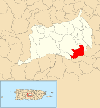
<span class="mw-page-title-main">Aguacate, Yabucoa, Puerto Rico</span> Barrio of Puerto Rico

Aguacate is a barrio in the municipality of Yabucoa, Puerto Rico. Its population in 2010 was 2,828.

<span class="mw-page-title-main">Daguao, Naguabo, Puerto Rico</span> Barrio of Puerto Rico

Daguao is a barrio in the municipality of Naguabo, Puerto Rico. Its population in 2010 was 2,273.

<span class="mw-page-title-main">Mariana, Naguabo, Puerto Rico</span> Barrio of Puerto Rico

Mariana is a barrio in the municipality of Naguabo, Puerto Rico. Its population in 2010 was 2,074.

<span class="mw-page-title-main">Hato Arriba, San Sebastián, Puerto Rico</span> Barrio of Puerto Rico

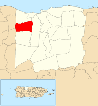
Hato Arriba is a barrio in the municipality of San Sebastián, Puerto Rico. Its population in 2010 was 1,980.

<span class="mw-page-title-main">Cedro, Cayey, Puerto Rico</span> Barrio of Puerto Rico

Cedro is a barrio in the municipality of Cayey, Puerto Rico. Its population in 2010 was 372.

<span class="mw-page-title-main">Sud, Cidra, Puerto Rico</span> Barrio of Puerto Rico

Sud is a barrio in the municipality of Cidra, Puerto Rico. Its population in 2010 was 3,714.

<span class="mw-page-title-main">Río Blanco, Naguabo, Puerto Rico</span> Barrio of Puerto Rico

Río Blanco is a barrio in the municipality of Naguabo, Puerto Rico. Its population in 2010 was 3,412.

<span class="mw-page-title-main">Bauta Arriba</span> Barrio of Orocovis, Puerto Rico

Bauta Arriba is a barrio in the municipality of Orocovis, Puerto Rico. Its population in 2010 was 913.

References

  1. 1 2 "US Gazetteer 2019". US Census. US Government.
  2. U.S. Geological Survey Geographic Names Information System: Cedro Arriba barrio
  3. Picó, Rafael; Buitrago de Santiago, Zayda; Berrios, Hector H. Nueva geografía de Puerto Rico: física, económica, y social, por Rafael Picó. Con la colaboración de Zayda Buitrago de Santiago y Héctor H. Berrios. San Juan Editorial Universitaria, Universidad de Puerto Rico,1969.
  4. Gwillim Law (20 May 2015). Administrative Subdivisions of Countries: A Comprehensive World Reference, 1900 through 1998. McFarland. p. 300. ISBN   978-1-4766-0447-3 . Retrieved 25 December 2018.
  5. Puerto Rico: 2010 Population and Housing Unit Counts.pdf (PDF). U.S. Dept. of Commerce, Economics and Statistics Administration, U.S. Census Bureau. 2010.
  6. "Anuario del comercio, de la industria, de la magistratura y de la administración. 1881". Biblioteca Nacional de España (in Spanish). p. 1614. Retrieved 4 April 2023.
  7. Joseph Prentiss Sanger; Henry Gannett; Walter Francis Willcox (1900). Informe sobre el censo de Puerto Rico, 1899, United States. War Dept. Porto Rico Census Office (in Spanish). Imprenta del gobierno. p.  162.
  8. 1 2 "Plan Territorial (2012)" (PDF). JP PR Gov (in Spanish). Gobierno Municipal de Naranjito -Oficina de Planificación y Ordenación Territorial. p. 43. Archived from the original (PDF) on 2019-06-12. Retrieved 26 June 2019.
  9. "Report of the Census of Porto Rico 1899". War Department Office Director Census of Porto Rico. Archived from the original on July 16, 2017. Retrieved September 21, 2017.
  10. "Table 3-Population of Municipalities: 1930 1920 and 1910" (PDF). United States Census Bureau. Archived (PDF) from the original on August 17, 2017. Retrieved September 21, 2017.
  11. "Table 4-Area and Population of Municipalities Urban and Rural: 1930 to 1950" (PDF). United States Census Bureau. Archived (PDF) from the original on August 30, 2015. Retrieved September 21, 2014.
  12. "Table 2 Population and Housing Units: 1960 to 2000" (PDF). United States Census Bureau. Archived (PDF) from the original on July 24, 2017. Retrieved September 21, 2017.
  13. Puerto Rico: 2010 Population and Housing Unit Counts.pdf (PDF). U.S. Dept. of Commerce Economics and Statistics Administration U.S. Census Bureau. 2010. Archived (PDF) from the original on 2017-02-20. Retrieved 2019-08-02.
  14. "US Census Barrio-Pueblo definition". factfinder.com. US Census. Archived from the original on 13 May 2017. Retrieved 5 January 2019.
  15. "Agencia: Oficina del Coordinador General para el Financiamiento Socioeconómico y la Autogestión (Proposed 2016 Budget)". Puerto Rico Budgets (in Spanish). Retrieved 28 June 2019.
  16. Rivera Quintero, Marcia (2014), El vuelo de la esperanza: Proyecto de las Comunidades Especiales Puerto Rico, 1997-2004 (first ed.), San Juan, Puerto Rico Fundación Sila M. Calderón, ISBN   978-0-9820806-1-0
  17. "Leyes del 2001". Lex Juris Puerto Rico (in Spanish). Retrieved 24 June 2020.
  18. "PRECINTO ELECTORAL NARANJITO 073" (PDF). Comisión Estatal de Elecciones (in Spanish). PR Government. 26 September 2019. Archived (PDF) from the original on 22 July 2020. Retrieved 21 July 2020.